Please register to participate in our discussions with 2 million other members - it's free and quick! Some forums can only be seen by registered members. After you create your account, you'll be able to customize options and access all our 15,000 new posts/day with fewer ads.
The latest model guidance for the Long Range with the ECMWF is certainly catching my attention. Why?
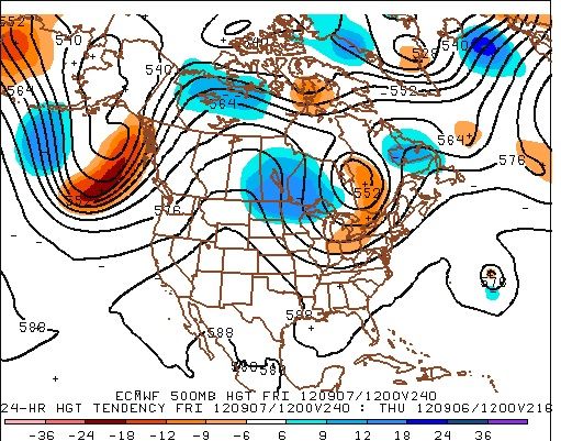
Well, let’s take a look at this pattern. We have a trough around the Aleutian Islands, which is a text book negative EPO pattern. We have a ridge over the Canadian West coast but a disturbance cutting under that ridge! Meanwhile, a tough is digging into the East, but this isn’t any trough. Note the 500 MB low around the Hudson Bay. That upper low is the Polar Vortex which is rather far to the south for this time of the year. This leads to building heights over Greenland and northeastern Canada. This pattern is a text book negative AO/NAO pattern.
Why do I have this interesting you might be wondering.
Well, what I find interesting is that this pattern is a typical pattern seen in cold season El Nino patterns. What really catches my attention is what’s happening around the Aleutian Islands as this deep trough kick starts the whole pattern to the east and supports the negative AO/NAO pattern. Even more interesting is the trough attempting to under cut the ridge over the West. This would suggest an active Sub Tropical jet stream is in play as well.
The pattern continues to evolve towards an El Nino pattern. If you love snow and cold, the development of a trough around the Aleutian Islands is a very good sign.
Farmers Alamanac predicts a "chilly and wet" winter for the SE. Hopefully this prediction will come to pass, but I don't know how accurate the Farmers Almanac is.
Please register to post and access all features of our very popular forum. It is free and quick. Over $68,000 in prizes has already been given out to active posters on our forum. Additional giveaways are planned.
Detailed information about all U.S. cities, counties, and zip codes on our site: City-data.com.

 Please register to participate in our discussions with 2 million other members - it's free and quick! Some forums can only be seen by registered members. After you create your account, you'll be able to customize options and access all our 15,000 new posts/day with fewer ads.