Quote:
Originally Posted by Cambium

July 1, 2013.
Confirmed EF0 in NJ. EF1 in CT. Microburst in Yonkers, NY. Microburst in Agawam, MA
Now they are surveying another area in SW CT to see if it was Straight Line Winds or Tornadic damage. I believe either Greenwich, Ridgefield, Wilton or Danbury or all towns since there were reports of trees down and power outages.
National Weather Service Text Product Display |
Add another Tornado in CT yesterday. What a day. I think we met the average now. lol
National Weather Service Text Product Display
PUBLIC INFORMATION STATEMENT
NATIONAL WEATHER SERVICE NEW YORK NY
254 PM EDT TUE JUL 2 2013
...TORNADO CONFIRMED IN THE TOWNS OF GREENWICH AND STAMFORD IN
FAIRFIELD COUNTY CONNECTICUT...
LOCATION...GREENWICH TO STAMFORD IN FAIRFIELD COUNTY CONNECTICUT
DATE...JULY 1 2013
ESTIMATED TIME...1058 AM TO 1108 AM EDT
MAXIMUM EF-SCALE RATING...EF-0
ESTIMATED MAXIMUM WIND SPEED...80 MPH
MAXIMUM PATH WIDTH...150 YARDS
PATH LENGTH...3.7 MILES
BEGINNING LAT/LON...41.11N / 73.63W
ENDING LAT/LON...41.12N / 73.56W
* FATALITIES...0
* INJURIES...0
* THE INFORMATION IN THIS STATEMENT IS PRELIMINARY AND SUBJECT TO
CHANGE PENDING FINAL REVIEW OF THE EVENT(S) AND PUBLICATION IN
NWS STORM DATA.
...SUMMARY...
THE NATIONAL WEATHER SERVICE IN NEW YORK NY HAS CONFIRMED A
TORNADO IN THE TOWNS OF GREENWICH AND STAMFORD IN FAIRFIELD COUNTY
CONNECTICUT ON JULY 1 2013. THE TORNADO TOUCHED DOWN IN THE TOWN
OF GREENWICH ON NORTH STREET JUST NORTH OF THE MERRITT PARKWAY. IT
CONTINUED EAST-NORTHEAST INTO THE TOWN OF STAMFORD AND LIFTED ON
JANES LANE APPROXIMATELY A HALF MILE WEST OF SCOFIELDTOWN ROAD.
EXTENSIVE TREE DAMAGE WAS OBSERVED ALONG THE TORNADO PATH
STARTING ON TACONIC ROAD AND CONTINUING ONTO SKYRIDGE ROAD. THE
WORST TREE DAMAGE WAS OBSERVED JUST SOUTH OF THE INTERSECTION OF
STAG LANE AND STANWICH ROAD. TREE DAMAGE CONTINUED ON CARRINGTON
DRIVE AND AT THE MEAD HOUSE FARM. THE TORNADO STARTED TO WEAKEN AS
IT MOVED INTO THE TOWN OF STAMFORD JUST SOUTH OF WEB HILLS ROAD
AND LYNAM ROAD. NO VISIBLE STRUCTURAL DAMAGE WAS SEEN DURING THE
SURVEY.
THE NATIONAL WEATHER SERVICE WOULD LIKE TO THANK THE CONNECTICUT
DEPARTMENT OF EMERGENCY SERVICES AND PUBLIC PROTECTION...TOWN OF
GREENWICH PARKS AND TREES DIVISION...AND THE TOWN OF GREENWICH AND
STAMFORD POLICE DEPARTMENTS.

 Please register to participate in our discussions with 2 million other members - it's free and quick! Some forums can only be seen by registered members. After you create your account, you'll be able to customize options and access all our 15,000 new posts/day with fewer ads.


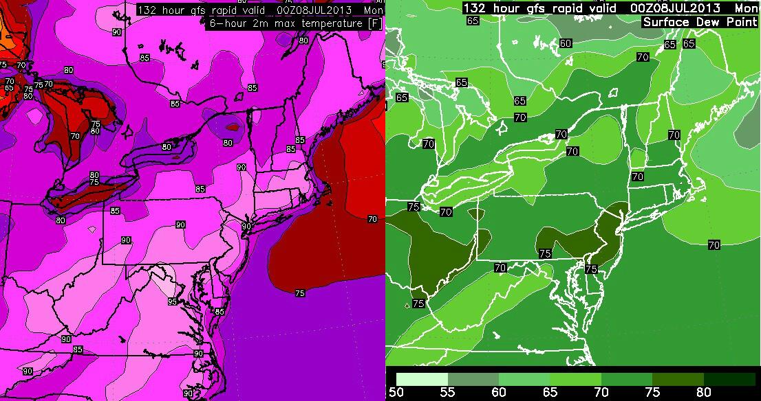
 This weekend & next week could become brutal