Please register to participate in our discussions with 2 million other members - it's free and quick! Some forums can only be seen by registered members. After you create your account, you'll be able to customize options and access all our 15,000 new posts/day with fewer ads.
Ok, so GFS did excellent with these warm temps currently and this weekend back to 10 days before. Lets see how it does with this..
GFS consistantly showing a Tropical system in the Gulf for days now. It continues to hit Florida and southeast with it around the 7th/8th and the latest takes the moisture up the coast.. Euro takes it to New Orleans.
Notice the 1st 2 frames here from the GFS. Thursday evening near Florida, ton of water, then Saturday morning still over Georgia/South Carolina. That means Florida gets soaked for a good 24hrs with Tropical convection.
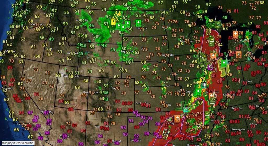
tarzan_taborda, West Coast Temps and Radar. Nasty line coming across in the plains. Lots of reports and warnings in the central U.S. looks nice and cool out west excpt the southwest
Typical to see a Ridge in the East, and Trough in West
Not surprising to see the main areas in the 90s are Baltimore, Philly, NYC, & Hartford metros
Otherwise it's pretty much 80s widespread in the East
The East Coast region as a whole seems to be more prone to April and May heat waves than sites deeper in the interior, even if the interior sites have warmer averages. NYC's record high for May is 99F, compared to 98F for St. Louis, whose average high is 5F warmer than NYC. Nashville's record of 96F is cooler still, and it averages 8F warmer than NYC.
It is weird, though, to see the 90's clustered in the East Coast urban corridor, even in places that don't have much of an urban heat island effect . Perhaps it's a "perfect storm" of having a low enough elevation and a high enough distance from the cooler ocean water. That seems to be the case in the New York City area.
Quote:
Originally Posted by tarzan_taborda
101 F in Jackson, is that right?
Probably not, since even weather stations only a few miles away with similar geography aren't registering anything close to 101F.
NYC will bake in the 90's for one more day before cooling down to the 80's. Meanwhile, there are forecast to be scattered snow showers in the Yellowstone region tonight, with a low of 27F and a brisk wind forecast for Yellowstone Lake. Lows will not rise above 37F for the next 10 days in the Yellowstone area per TWC's forecast. As usual, the Yellowstone region is one of the last outposts of consistently cool weather in the lower 48, and unless there is a freak outbreak of high humidity in the region it should stay cool for the remainder of the summer season.
Of course there is plenty of cool and even cold weather left in Alaska. Barrow is sitting at 32F with snow in the vicinity, and won't rise above 40F for at least the next 10 days.
The East Coast region as a whole seems to be more prone to April and May heat waves than sites deeper in the interior, even if the interior sites have warmer averages. NYC's record high for May is 99F, compared to 98F for St. Louis, whose average high is 5F warmer than NYC. Nashville's record of 96F is cooler still, and it averages 8F warmer than NYC.
It is weird, though, to see the 90's clustered in the East Coast urban corridor, even in places that don't have much of an urban heat island effect . Perhaps it's a "perfect storm" of having a low enough elevation and a high enough distance from the cooler ocean water. That seems to be the case in the New York City area.
Interesting idea that we're more prone to late spring heat waves. Might be right. as the 90s clustered outside of the urban island that's rather common. Hartford, CT up through Western MA recorded the highest temperatures of a late May heatwave a few years back (98°F for Amherst, MA) among the hottest temperatures in the entire country that day. Western Upstate NY does appear less heatwave prone than interior New England for whatever reason. Newark, NJ hit 93°F, NYC Central Park 90°F, Chicopee, MA (nearest official weather station to my home) 91°F. Currently 84°F in both Newark and Central Park, 86°F at LaGuardia Airport in NYC and 67°F Chicopee. I'm in NYC at the moment and I'm finding unpleasant without A/C, back home, I'd be comfortable. Will be nice to be back home...
Interestingly, even colder is another site in NYC — JFK Airport at 64°F. A light breeze from the south from the nearby Atlantic has caused a quick cooldown.
Too hot for you? Think Ice Bergs & take a look at this one spotted yesterday 5/29 in Twillingate Newfoundland. They actually have boat tours for this. http://icebergquest.com/
KMEM (Memphis Int'l) so far has gone all May without reaching 90F, highest temperature is 89F (yesterday). There is a chance of reaching 90 tomorrow - forecasts are about 88F or 89F. If it dosen't happen, then it will at least be another week before there's another chance.
Want to post this here to show those who arent familiar with a rain shaft. This is a perect picture to show it. From Nahant, MA June 8, 2012. Photographer said its a "hail shaft" which is possible too if hail actually was falling at the time.
Basically you have clouds over head from a storm but an area where the rain is falling. In this case over that island there. You can also see the rain shaft to the left more as well where its raining. But notice a few breaks in between.
Next time its raining over you, think about how it looks from a distance or up above. This also should help realize that it can easily rain above you and not in a nearby town.
Even with the high of 89° yesterday which was 17 above normal, Bridgeport, BDR monthly temp average is 58.8° which is -0.2 below normal. Today will change that and go into above normal.
Windsor Locks, BDL monthly temp departure went from -0.1 yesterday to now above normal at 0.4 for the month.
What ashame that the last 2 or 3 days alone changes the whole perspective of the month when we look back at the departures. Instead of showing we were below normal for 29 days worth, the maps will show above normal now and all we'll think about is how "May" was above normal
It's something I always think about when looking at stats and maps regarding departures but we have no choice I guess. Just keep this in mind next time you look at them. Was there a few days at the end that changed us into below or above normal for the month?
Please register to post and access all features of our very popular forum. It is free and quick. Over $68,000 in prizes has already been given out to active posters on our forum. Additional giveaways are planned.
Detailed information about all U.S. cities, counties, and zip codes on our site: City-data.com.

 Please register to participate in our discussions with 2 million other members - it's free and quick! Some forums can only be seen by registered members. After you create your account, you'll be able to customize options and access all our 15,000 new posts/day with fewer ads.


")
 . Perhaps it's a "perfect storm" of having a low enough elevation and a high enough distance from the cooler ocean water. That seems to be the case in the New York City area.

