Please register to participate in our discussions with 2 million other members - it's free and quick! Some forums can only be seen by registered members. After you create your account, you'll be able to customize options and access all our 15,000 new posts/day with fewer ads.
On the other side, it's harder to get extreme heat centered over the northeast.
? Hmm, I think the Bermuda high or Ridge gets centered over us many times. We can look at maps that show this. The heat ridge is so much easier to center over the East than a trough. Maybe the Atlantic ridge has something to do with this preventing the trough to just park itself over us?
I guess another way to see this is to look at the actual departures. Isnt it strange how the warmer departures are always higher and longer lasting than the cold departures?
But take a look at July 15th. We rarely get a trough to do this.
? The Bermuda high or Ridge gets centered over us many times. We can look at maps that show this. The heat ridge is so much easier to center over the East than a trough. Maybe the Atlantic ridge has something to do with this preventing the trough to just park itself over us?
I guess another way to see this is to look at the actual departures. Isnt it strange how the warmer departures are always higher and longer lasting than the cold departures?
But take a look at July 15th. We rarely get a trough to do this.
True, the ridge got centered over us. But what I meant is the east seems not get the center of any intense heat wave. We got near record breaking heat this July. But take a look at it:
compare to last July
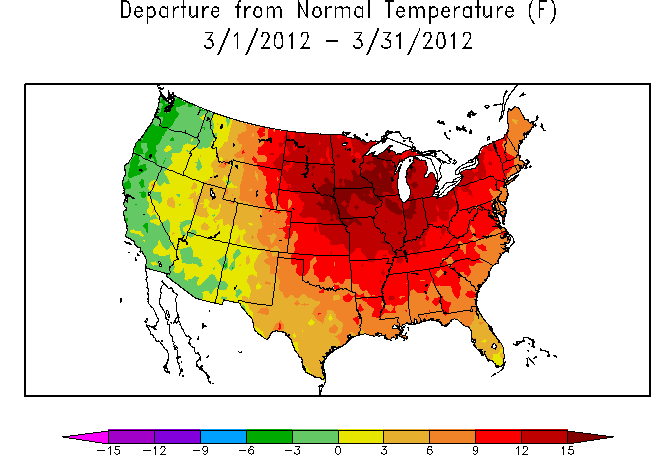
or March:
perhaps you could find an alternative example with extreme heat or cool concentrated along the coast, but my point is that extreme cold or heat tends to "pool" in the interior.
Getting a ridge parked over the east coast, creates stably hot weather, but not as extreme departure inland. If you look at July 2009, the coldest was again in the midwest, not the east coast.
True, the ridge got centered over us. But what I meant is the east seems not get the center of any intense heat wave. We got near record breaking heat this July. But take a look at it:
compare to last July
or March:
perhaps you could find an alternative example with extreme heat or cool concentrated along the coast, but my point is that extreme cold or heat tends to "pool" in the interior.
Getting a ridge parked over the east coast, creates stably hot weather, but not as extreme departure inland. If you look at July 2009, the coldest was again in the midwest, not the east coast.
Interesting... not sure if 30 days worth of data is what I was searching for though. Troughs and ridges move on a daily basis so I was wondering if and when we got a trough to center over us on any given day. Also, I wasnt talking about extreme cold. Just that trough and a ridge weather it gives us seasonable temps, above normal, or below normal... Let me see if I can find a trough example for us.
(obviously a trough centered over us in the summer isnt going to bring extreme cold, so I was just curious more about the setupt than extreme temps)
perhaps you could find an alternative example with extreme heat or cool concentrated along the coast, but my point is that extreme cold or heat tends to "pool" in the interior.
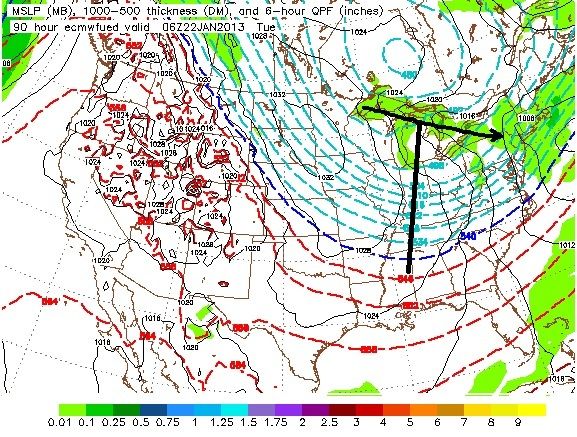
Using this time frame because its when I remember it got cold so maybe the trough was centered over us. I can't recall other times just yet, I'll have to keep searching.
It's Euro for Jan 22nd timeframe. Here its centered over the Tennessee valley. It did shift east BUT it flattened out, wasnt as deep, and was very short lived.
Maybe our latitude and the "speed" is one factor. The Atlantic is another?
This isnt the best example for us but maybe showing the point that it can be centered anywhere in the country easily...I'll keep looking.
Summer is over here in Buxton by far. No 20°C in the forecast (which is only slightly above average anyway), mid-high teens crap, overcast every day, no storms on the horizon. Truly the worst rubbish you can get in "summer", reminiscent of the worst of any of the previous few summers.
Sickening and distressing. Oh well. I'll just wait for next summer patiently while everyone else enjoys the 10 months of cold grot to follow.
I got a reply back from Steve D regarding my question.
"It's a multiple of factors from the 500 MB wave length amplification to the influence of the ridge over the western Atlantic. I think right now the western Atlantic ridge is the primary threat to keeping the trough from digging and dominating the eastern United States.
Frankly, the natural thermal gradient between the Atlantic Ocean and North America would typically keep the East coast on the eastern side of a trough. So that is another factor in preventing a trough axis to remain sustained over New England and the Mid Atlantic."
Summer is over. The sea temps are dropping and day length is declining by 4 minutes everyday. I don't expect many 20c temps now and thank god.
Doom and horrible weather is upon us soon!
Please register to post and access all features of our very popular forum. It is free and quick. Over $68,000 in prizes has already been given out to active posters on our forum. Additional giveaways are planned.
Detailed information about all U.S. cities, counties, and zip codes on our site: City-data.com.

 Please register to participate in our discussions with 2 million other members - it's free and quick! Some forums can only be seen by registered members. After you create your account, you'll be able to customize options and access all our 15,000 new posts/day with fewer ads.