Please register to participate in our discussions with 2 million other members - it's free and quick! Some forums can only be seen by registered members. After you create your account, you'll be able to customize options and access all our 15,000 new posts/day with fewer ads.
Weatherfan should be pleased - GFS Shows uppers of 20C reaching SE England with 15C+ over most of England and even southern Scotland, with temperatures reaching 31C. One of the hottest charts I have seen since 2006.
Really? Don't believe that will verify! That'll be the day! Knowing our luck it will all get shunted east and into Finland or somewhere.
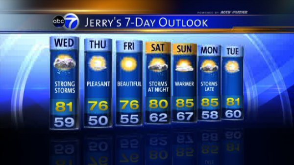
452 PM EDT TUE JUN 11 2013 RATHER CHILLY PATTERN EXPECTED FOR MOST OF THIS WEEK. POTENT MID- LEVEL SHORTWAVE SHOULD AMPLIFY A MID-LEVEL TROUGH OVER NEW ENGLAND LATE THIS WEEK. THIS IN TURN SHOULD STEER A LOW PRESSURE SOUTH OF OUR REGION THURSDAY NIGHT INTO FRIDAY. CANADIAN AND ECMWF SOLUTIONS ARE SLOWER AND TRACK FARTHER SOUTH THAN THE REST OF THE GUIDANCE WHICH IS FAIRLY WELL CLUSTERED. LEANED MORE TOWARD THE GFS-LED CONSENSUS FOR NOW WITH THIS STORM THIS SYSTEM LOOKS MORE LIKE AN EARLY WINTER STORM ALOFT RATHER THAN A LOW MORE TYPICAL OF JUNE
359 PM EDT TUE JUN 11 2013
THURSDAY INTO FRIDAY...MODELS ARE IN FAIRLY GOOD AGREEMENT TRACKING A DEEPENING LOW PRESSURE SYSTEM EAST NORTHEAST FROM THE OHIO VALLEY THURSDAY MORNING THROUGH PENNSYLVANIA THURSDAY AND OFF THE MID ATLANTIC COAST THURSDAY NIGHT
.LONG TERM /FRIDAY NIGHT THROUGH TUESDAY/...
A LARGE RIDGE OF ARCTIC HIGH PRESSURE WILL BE SETTLING OVER THE MID ATLANTIC AND NORTHEAST DURING THIS TIME. THE HIGH WILL GRADUALLY FALL APART...BEING DISPLACED BY BOTH A WEAK SURFACE LOW OVER THE MID-ATLANTIC...AND A COLD FRONT APPROACHING FROM THE UPPER GREAT LAKES REGION
408 PM EDT TUE JUN 11 2013
MAIN CONCERN DURING THIS TIME PERIOD CONTINUES TO BE THE THU-FRI TIME PERIOD WITH AN ANOMALOUSLY INTENSE LOW PRESSURE SYSTEM AFFECTING THE AREA. MODELS ARE CONVERGING ON THE STRENGTH AND TIMING OF LOW PRESSURE AS IT APPROACHES THE EAST COAST FROM THE OHIO VALLEY ON THU...AND THEN INTENSIFIES AS IT TRACKS SOUTH OF THE AREA
THU NIGHT/EARLY FRI
HARD TO IGNORE THE GOOD MODEL AGREEMENT ON RAPID INTENSIFICATION OF LOW PRESSURE AS IT APPROACHES THE EAST COAST...DUE TO PHASING OF THE UPPER MIDWEST SHORTWAVE AND A STRONGER NORTHERN STREAM SHORTWAVE
Current evening temps are in the 100s in parts of Colorado and Kansas which is about 25-30 degrees above normal. Let the Heat Ridge begin. Sorry Central folks, this is what I was hoping to see.
Meanwhile dewpoints are nice and low in the 30s and 40s.
28 at O'Hare and 29C at Midway here in Chicago today. The lakeshore was at 26C..... Wednesday will reach around 27C with the threat of severe thunderstorms.... Between 24-29C the rest of the week...
Normal rainfall amount in NYC June 1st to June 11th is 1.76". They have 7.96"!
Normal rainfall amount in Bridgeport, CT is 1.57", they have 6.81"
Normal rainfall amount in Islip Long Island, NY is 1.80" they have 6.72"
Bridgeport,CT(BDR) needs .44” to have the 3rd wettest June on record.
They need 4.72" to have the 2nd most wettest June.
The wettest June on record was in 1972 where there was 24 days of precip.
28 at O'Hare and 29C at Midway here in Chicago today. The lakeshore was at 26C..... Wednesday will reach around 27C with the threat of severe thunderstorms.... Between 24-29C the rest of the week...
Yes, today looks warm in much of the Midwest.
In fact, most of the mainland will see 80's and 90's today as the heat from the southern plains moves eastward. That solar angle is really kicking now:
Its already at the east of the uk anyway. Always for them se ones. Always. It would be great to have a hot summer that doesnt affect them!
It's been totally removed from the latest outputs anyway so not happening anywhere now, and it is replaced with pathetic Atlantic dirge as USUAL. NOTHGIN interesting ever happens here in summer any more. Of course loads of deep north easterlies and snow in winter but no heatwaves in summer EVER. Why the fudge not? What is so hard about managing a heat plume or something one in about EIGHT YEARS maybe when we so easily get frigid cold every winter? We used to get heat plumes much more frequently.
Our average high cracks 80°F today, the forecast is 80°F as well.
Please register to post and access all features of our very popular forum. It is free and quick. Over $68,000 in prizes has already been given out to active posters on our forum. Additional giveaways are planned.
Detailed information about all U.S. cities, counties, and zip codes on our site: City-data.com.

 Please register to participate in our discussions with 2 million other members - it's free and quick! Some forums can only be seen by registered members. After you create your account, you'll be able to customize options and access all our 15,000 new posts/day with fewer ads.

 Really? Don't believe that will verify! That'll be the day! Knowing our luck it will all get shunted east and into Finland or somewhere.