Please register to participate in our discussions with 2 million other members - it's free and quick! Some forums can only be seen by registered members. After you create your account, you'll be able to customize options and access all our 15,000 new posts/day with fewer ads.
In Southern florida I don't think so somehow. Even if the uppers where to get cold enough it still probably wouldn't snow because the sea temperatures are too warm and nowhere is inland enough.
I mean 25c sea temperatures and you think it can snow. No!
We occasionally have problems with 5c sea temperatures and getting snow.
I mean 25c sea temperatures and you think it can snow. No!
It sure can snow with 25C sea temperatures, depending on how cold the original cold air mass is and how far away you are from the coast. It would take an extremely cold airmass, colder than what you'd need for it to snow in Ireland but it "could" happen. In a situation like that, Miami Beach's weather will be quite different from Lake Okeechobee. Also in a situation like that it's likely that the ocean (at least by the beach) wouldn't remain at 25C for long, given contact with cold air of such intensity.
Of course, since snow is so rare in South Florida the "snow with 25C SSTs" bit is rarely tested. It should be noted, though, that flakes did occur as far south as Homestead, Florida in January 1977. It's not a stretch to say that accumulations would also be possible under particular circumstances. During the last glacial period snow probably did occasionally fall in South Florida (whereas Orlando had a climate similar to a desertified Atlanta, so it likely did see snow annually), so it would be advisable to root for that.
It should also be noted that some of the recent GFS runs have consistently showed a very potent cold air outbreak in the United States. Is it likely to snow that far south? No. But some extreme cold and snow could be coming to some American locales.
you will see snow very close to you this winter. Save this post but lets not go off topic now.
Northern Florida and Georgia is close. Nobody is talking about neighborhoods especially when it comes to a 3 month prediction. This is Off topic folks.
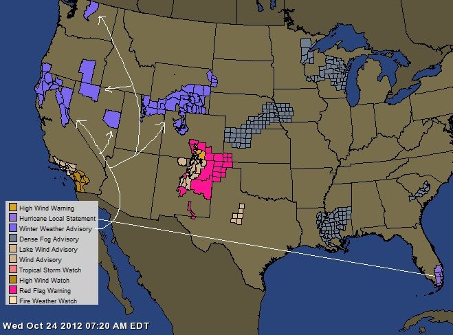
Special Weather Statement for the West
132 PM PDT FRI OCT 19 2012
...MAJOR CHANGE IN THE WEATHER PATTERN COMING
Winter Storm Watch for California Counties of Alpine, Amador, Butte, Calaveras, El Dorado, Lassen, Nevada, Placer, Plumas, Shasta, Sierra, Tehama, Yuba
Winter Storm Watch for Nevada Counties of Carson City, Douglas, Washoe
Winter Storm Watch for Washington counties of Clallam, Grays, Harbor, Jefferson,
King, Lewis, Mason, Pierce, Skagit, Snohomish, Whatcom
THE NATIONAL WEATHER SERVICE IN SACRAMENTO,CA HAS ISSUED A WINTER
STORM WATCH ABOVE 5500 FEET...WHICH IS IN EFFECT FROM SUNDAY
EVENING THROUGH LATE MONDAY NIGHT.
* SNOW ACCUMULATIONS: 6 TO 12 INCHES POSSIBLE.
* ELEVATION: ABOVE 5500 FEET.
* TIMING: STARTING LATE SUNDAY EVENING CONTINUING INTO TUESDAY
MORNING. HEAVIEST SNOW LIKELY LATE SUNDAY NIGHT INTO MONDAY
MORNING.
---------------------------------
THE NATIONAL WEATHER SERVICE IN RENO,NV HAS ISSUED A WINTER STORM
WATCH...WHICH IS IN EFFECT FROM MONDAY MORNING THROUGH LATE
MONDAY NIGHT.
* TIMING: EARLY MONDAY MORNING THROUGH LATE MONDAY NIGHT.
* SNOW ACCUMULATIONS: UP TO ONE FOOT POSSIBLE ALONG THE SIERRA
CREST ABOVE 7000 FEET...UP TO SIX INCHES BELOW 7000 FEET
------------------------
THE NATIONAL WEATHER SERVICE IN SEATTLE,WA HAS ISSUED A WINTER STORM
WATCH...WHICH IS IN EFFECT FROM THIS EVENING THROUGH SATURDAY
AFTERNOON FOR THE OLYMPICS...NORTH AND CENTRAL CASCADES OF WESTERN
WASHINGTON ABOVE 3000 FEET.
* TIMING...LATE THIS EVENING THROUGH SATURDAY. HEAVIEST SNOWFALL
IS LIKELY LATE TONIGHT AND SATURDAY MORNING.
* SNOW ACCUMULATIONS...4 TO 8 INCHES. HEAVIEST AMOUNTS OCCUR NEAR
STEVENS PASS DUE TO ENHANCEMENT FROM THE CONVERGENCE ZONE.
* SNOW LEVEL...FALLING TO 4500 FEET LATE THIS EVENING...THEN DOWN
TO 3000 FEET BY EARLY SATURDAY MORNING
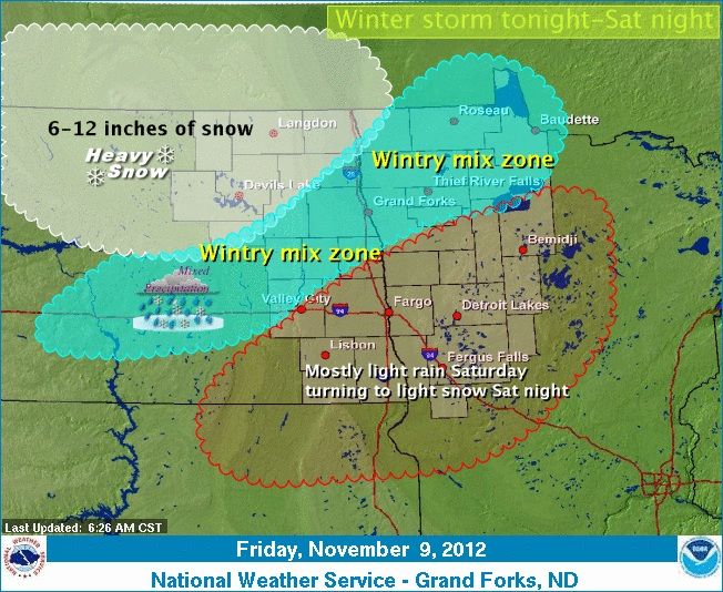
the national weather service in great falls has cancelled the
winter weather advisory below 4500 feet and replaced it with a
winter storm warning. A winter storm warning remains in effect until
noon mdt tuesday for elevations above 4500 feet.
A winter storm warning is in effect from 3 pm this afternoon to
noon mdt tuesday. The winter weather advisory is no longer in effect.
* timing: Widespread snow will develop over the mountains of the
rocky mountain front by late this afternoon. Snow will be heavy
at times. Snow will diminish tuesday morning.
* snow accumulations: total amounts of 8 to 12 inches are likely with
isolated amounts of 16 inches in the mountains.
* winds and visibility: Northeast to northwest winds of 10 to 20
mph will cause areas of drifting snow with reduced visibilities.
* other impacts: Travel through mountain passes will become
difficult with snow covered roads. Hunters and other outdoor
enthusiasts should be prepared for winter conditions.
So basically snow is extremely rare in southern Florida.
Exactly. Very rare. That means by definition that it does happen perhaps once or twice per century, dependent on climatic changes (such as the LIA when Florida snow was not as rare)
...BLIZZARD WARNING REMAINS IN EFFECT UNTIL 11 AM MST SATURDAY...
A BLIZZARD WARNING REMAINS IN EFFECT UNTIL 11 AM MST SATURDAY.
* TIMING: SNOW WILL BE HEAVY AT TIMES TONIGHT THROUGH FRIDAY
WITHSNOW EXPECTED TO DIMINISH LATE SATURDAY MORNING. EAST
WINDS WILL INTENSIFY THIS EVENING...CREATING BLIZZARD
CONDITIONS.
* SNOW ACCUMULATIONS: TOTAL SNOW ACCUMULATIONS THROUGH SATURDAY
MORNING OF 8 TO 12 INCHES ARE EXPECTED AT LOWER ELEVATIONS...
WITH10 TO 20 INCHES EXPECTED IN THE MOUNTAINS.
Please register to post and access all features of our very popular forum. It is free and quick. Over $68,000 in prizes has already been given out to active posters on our forum. Additional giveaways are planned.
Detailed information about all U.S. cities, counties, and zip codes on our site: City-data.com.

 Please register to participate in our discussions with 2 million other members - it's free and quick! Some forums can only be seen by registered members. After you create your account, you'll be able to customize options and access all our 15,000 new posts/day with fewer ads.


") This is Off topic folks.
This is Off topic folks.