Please register to participate in our discussions with 2 million other members - it's free and quick! Some forums can only be seen by registered members. After you create your account, you'll be able to customize options and access all our 15,000 new posts/day with fewer ads.
Euro this afternoon continues the Big Storm idea, GFS does not. GFS tends to lose things in mid range, I call that the mid range crisis.
Euro prints out the Long Island Express Hurricane from 1938. Pretty much almost exact.
If I still see it there tonight, my confidence goes up on something big happening. If all models lose it, then I hit the reset button.
Fascinating. It still appears that something big is afoot in the early cold/snow department. Not necessarily a big East Coast storm, but something big. There seems to be huge cold and snow afoot everywhere. New Zealand, the West, the East, Europe - it's amazing to see.
Quote:
Originally Posted by Cambium
Like I've been talking about for weeks it seems and some gave me hard time for. LOL! Gotta trust the models...and your gut.
Exactly. Just like Snowtober in 2011, consistency is key, and if you read it correctly, model accuracy from two weeks out can be relatively impressive.
Quote:
Originally Posted by Cambium
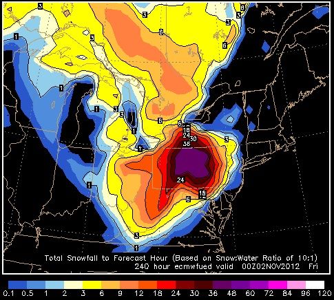
If 9-12" of snow in October happens, its concerning... If 48-60" of snow happens with 1 storm, its destruction. How ridiculas is this run by the Euro last night????
So the Euro takes the Hurricane from Carribean, rides up the Gulf Stream jst off the coast, becomes a 950mb Low, makes an East turn into NYC, stalls out over PA, Cold air filters into it. Snow totals on the right.
GFS 00z and 6z lose the storm.
#1. I have never heard of those amounts of snow happening historically with 1 storm in October.
#2. I have never seen this result with a model before
#3. I am still not buying the big storm senario
#4. If todays and tomorrows model runs continue to show it, I will.
I just have to say WOW to that . I don't care if it's even close to reality - it's jaw-dropping just to see any model run have those amounts of snow at any time of year, let alone before Halloween. If that occurred it would probably be the most extreme weather event ever recorded in the Northeast. It would make the October Blizzard last year seem like a flurry.
While the scenario described, with a hurricane coming up, running into cold air, and dumping huge amounts of snow, could happen, it probably won't happen since no other runs have shown such extreme numbers. The general scenario, though, of tropical moisture coming up and producing snow somewhere in the East, does appear to have some support. I'd also like to point out that the late February 2010 storm was described as a "Snowicane". This scenario is a real Snowicane.
It should also be noted that this is similar to several thought experiments I had, with an upslope flow-type mountain range that was high and cold enough for snow, but situated in a hurricane-prone area. I figured huge snowstorms would result from the hurricanes that came in, and this provides an almost-real-life example.
About the output itself, 4-5 feet of snow before Halloween is incredible, extreme, and dare I say awesome. If that occurred it would make everything that's happened in the last few years look like nothing, and would spark talk of "if it does this in October, what will it do in January?", even though that is likely the most moisture you could possibly get, and thus the greatest potential snow in your current climate regime.
While the scenario described, with a hurricane coming up, running into cold air, and dumping huge amounts of snow, could happen, it probably won't happen since no other runs have shown such extreme numbers. The general scenario, though, of tropical moisture coming up and producing snow somewhere in the East, does appear to have some support. I'd also like to point out that the late February 2010 storm was described as a "Snowicane". This scenario is a real Snowicane.
My guess is that computer errors combined to predict two unlikely events (cold air and tropical moisture) happening at once, to predict something nearly unheard of. Interesting as a scenario, though.
Euro continues to slam into the NorthEast... this time gives 3 feet+ of snow to most of PA. insane. Tropical Storm wind gusts to the NorthEast and Flooding of course. 950mb low outside LongIsland before turning west into land
I suggest you read you're local NWS discussion, they are mentioning the potential now. Still 6 days away.
My guess is that computer errors combined to predict two unlikely events (cold air and tropical moisture) happening at once, to predict something nearly unheard of.
As Cambium has posted, there's much more consistency than what would happen with a computer error. Every storm has its extreme model runs (one showing feet, the other showing nothing), but it's the magnitude of the extremity here that is incredible.
Quote:
Interesting as a scenario, though.
Indeed. I've always thought that hypothetically the most extreme snow totals would come if hurricanes could impact and have their moisture changed to snow. Orographic enhancement would help, too. Hurricane Mitch dumped 16.85 inches of rain at its peak; that could make 169 inches of the white stuff.
Yes. GFS shifted closer to coast but still OTS. GFS is the only one to show OTS. I will re-evaluate later on. It's all about that trough out west. Thats going to make or break it.
If models continue to show this on Thursday it will be the most talked about this for the next 4 days and if it happens as suggested, it will be a 100yr event.
It looks similar, only this year it's showing colder air and a stronger storm. If they do get a Snowtober repeat, mark me down as the first to post about of the possibility .
If there was 2-5 feet of snow on Halloween, there would be the aforementioned "what will happen in winter if this can happen in October" crowd, but some other people might think another warm winter is upcoming. In that case it would be really funny if the same cold and stormy pattern promptly locked in until the end of March. It would also be cruel to the warm weather fans, but haven't coldies in the Northeast gone through enough cruelty over the years?
Please register to post and access all features of our very popular forum. It is free and quick. Over $68,000 in prizes has already been given out to active posters on our forum. Additional giveaways are planned.
Detailed information about all U.S. cities, counties, and zip codes on our site: City-data.com.

 Please register to participate in our discussions with 2 million other members - it's free and quick! Some forums can only be seen by registered members. After you create your account, you'll be able to customize options and access all our 15,000 new posts/day with fewer ads.


 .
.
