Please register to participate in our discussions with 2 million other members - it's free and quick! Some forums can only be seen by registered members. After you create your account, you'll be able to customize options and access all our 15,000 new posts/day with fewer ads.
Well, this is the UK we have sea around us so it is hard for the snow to stick really before the end of november because the soil is too warm.
I'd think by the current temps of your area that snow would be rare at low levels in october where you live. Obviously last years storm was rare.
October's storm was unheard of. Some places around me got nearly 1 foot of snow while to the west one spot in the hills got 30 inches.
I do remember at least several times of snow falling not sticking, even in Long Island. Last October, we got a very minor snowfall right before the storm, stayed on the ground in some spots for an hour or two. Some inland spots of Northeast, at least in the hills, maybe get 1-2 feet of snow next week.
YES but someone mentioned 80f in PA the other day. If conditions are like that every year then I'd sat it would be very hard to see snow falling in October.
I don't think -9c uppers is a common occurrence in October. Now, don't be silly.
I didn't mention a thing about -9C "uppers". Air frost is normal enough here in October. There isn't going to be any snow here this time around and it is just like 20th Oct 2010 no worse.
YES but someone mentioned 80f in PA the other day. If conditions are like that every year then I'd sat it would be very hard to see snow falling in October.
It's not 80F all the time in Pennsylvania. Most of the time it's somewhat cooler than 80F. It's a matter of continental vs. oceanic geography and weather patterns.
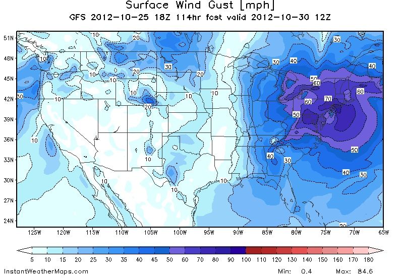
GFS wind gust predictions on October 30. Copying from Cambium's post on another thread because this is impressive enough that it deserves a post:
It looks to be (maybe) a historic storm.
I saw your question in the other CT thread to me about the clouds: I think you most certainly WILL see all of those cloud patterns in the coming days above central Massachuttes:
You should see cirrus over riders late on Fri…then those tropical “hot towers “ (I love those cloud formations, I first saw them in St. Thomas in the USVI) will start to appear by Sun. Look for the them in the southeast sky, moving in a west to northwest direction. You’ll also notice the increase in dew points and humidity as at least some of that air mass surrounding Sandy will be very tropical. I remember when past tropical cyclones (Irene, Bob, ..etc.) got closer and closer you could just feel the heat and moisture rising. It was pretty cool to experience these outer effects. If I were you I would take a trip down to the Rhode Island coast or at least the Lighthouse near Chatham to see the waves (and watch the surfers - lol). If Sandy is as intense as they think it will be when it gets off Long Island/Mid Atlantic - folks on the East Coast above North Carolina might not get a chance like this again for a long time.
Interesting but looking at the forecast for New Haven, CT, I don't see highs above 60°F from Sunday-Tuesday. So non-tropical dewpoints. Unless the forecast isn't reflecting the storm, which is quite possible.
Interesting but looking at the forecast for New Haven, CT, I don't see highs above 60°F from Sunday-Tuesday. So non-tropical dewpoints. Unless the forecast isn't reflecting the storm, which is quite possible.
Yes, often the NWS will not reflect what a tropical cyclone will do to the local weather until we are 24 to 36 hrs away.
As far as temps/dew points/and the sense of increasing humidty…trust me you’ll feel it if Sandy stikes the East Coast within 200 miles of you (that would be between say Boston to Cape May). I’ve been through enough tropical systems in Florida and even here in southern CT to know that feeling well – the air gets so sticky and humid it feels like you’re in the Amazon – lol. It's not really so much that the surface temps get so high (although typically they are at least 70 F ).
It is late in the season, and there will be some cool air/dry mixing in esp north of Rhode Island…but I think (if Sandy strikes close enough and stays a tropical system) you’ll feel the sensation of that tropical air big time. You know, in all the tropical storms I’ve been through (11 in all), it’s not the wind, the rain, the flooding…etc it’s that sensation of that deep wet tropical air that I always thought was the oddest sensation.
Still who knows, Sandy is looking more like it will affect at least some part of the East Coast…but it could still weaken or turn out to sea. So we just wait I guess…
Please register to post and access all features of our very popular forum. It is free and quick. Over $68,000 in prizes has already been given out to active posters on our forum. Additional giveaways are planned.
Detailed information about all U.S. cities, counties, and zip codes on our site: City-data.com.

 Please register to participate in our discussions with 2 million other members - it's free and quick! Some forums can only be seen by registered members. After you create your account, you'll be able to customize options and access all our 15,000 new posts/day with fewer ads.