Please register to participate in our discussions with 2 million other members - it's free and quick! Some forums can only be seen by registered members. After you create your account, you'll be able to customize options and access all our 15,000 new posts/day with fewer ads.
No tropical storm here but still fairly wet: the month will end with close to 150% of average rainfall after either 23 or 24 wet days, and rain is forecast for the first five days of November after that. Eight of the past ten days have also been 100% overcast.
It's crazy how the weather can vary so much over a relatively short distance.
52mm here for the month which is probably below average, and 112 hours of sunshine.
112 hours... the dodgy unofficial total for here is 47.5 but considering Heathrow is on 76.7 I suspect the official Hampstead running total is around 60-65, with no more than five more predicted for the last three days. It's probably one of the lowest in the country - Tiree is the highest I could find on 116.1 hours, which shows how topsy-turvy it has been.
112 hours... the dodgy unofficial total for here is 47.5 but considering Heathrow is on 76.7 I suspect the official Hampstead running total is around 60-65, with no more than five more predicted for the last three days. It's probably one of the lowest in the country - Tiree is the highest I could find on 116.1 hours, which shows how topsy-turvy it has been.
We're getting a really low sunshine stretch here, too. Since Tuesday noon, we've had a few hours of sunshine at most (mainly late Friday afternoon). I don't see any sun in the forecast till Saturday.
NWS information statements making emotional pleas about the impending storm. I've never seen that in a weather bulletin before.
PUBLIC INFORMATION STATEMENT
NATIONAL WEATHER SERVICE MOUNT HOLLY NJ
241 PM EDT SUN OCT 28 2012
...AN EXTREMELY DANGEROUS STORM TO IMPACT THE AREA...
SANDY IS EXPECTED TO SLAM INTO THE NEW JERSEY COAST LATER MONDAY
NIGHT, BRINGING VERY HEAVY RAIN AND DAMAGING WINDS TO THE REGION.
THE STORM IS A LARGE ONE, THEREFORE DO NOT FOCUS ON THE EXACT CENTER
OF THE STORM AS ALL AREAS WILL HAVE SIGNIFICANT IMPACTS.
THIS HAS THE POTENTIAL TO BE AN HISTORIC STORM, WITH WIDESPREAD WIND
DAMAGE AND POWER OUTAGES, INLAND AND COASTAL FLOODING, AND MASSIVE
BEACH EROSION. THE COMBINATION OF THE HEAVY RAIN AND PROLONGED WIND
WILL CREATE THE POTENTIAL FOR LONG LASTING POWER OUTAGES AND SERIOUS
FLOODING.
PREPARATIONS SHOULD BE WRAPPING UP AS CONDITIONS ARE EXPECTED TO
WORSEN TONIGHT AND ESPECIALLY ON MONDAY.
SOME IMPORTANT NOTES...
1. IF YOU ARE BEING ASKED TO EVACUATE A COASTAL LOCATION BY STATE
AND LOCAL OFFICIALS, PLEASE DO SO.
2. IF YOU ARE RELUCTANT TO EVACUATE, AND YOU KNOW SOMEONE WHO RODE
OUT THE `62 STORM ON THE BARRIER ISLANDS, ASK THEM IF THEY COULD DO
IT AGAIN.
3. IF YOU ARE RELUCTANT, THINK ABOUT YOUR LOVED ONES, THINK ABOUT
THE EMERGENCY RESPONDERS WHO WILL BE UNABLE TO REACH YOU WHEN YOU
MAKE THE PANICKED PHONE CALL TO BE RESCUED, THINK ABOUT THE
RESCUE/RECOVERY TEAMS WHO WILL RESCUE YOU IF YOU ARE INJURED OR
RECOVER YOUR REMAINS IF YOU DO NOT SURVIVE.
4. SANDY IS AN EXTREMELY DANGEROUS STORM. THERE WILL BE MAJOR
PROPERTY DAMAGE, INJURIES ARE PROBABLY UNAVOIDABLE, BUT THE GOAL IS
ZERO FATALITIES.
5. IF YOU THINK THE STORM IS OVER-HYPED AND EXAGGERATED, PLEASE ERR
ON THE SIDE OF CAUTION.
WE WISH EVERYONE IN HARMS WAY ALL THE BEST. STAY SAFE!
$$
NWS MOUNT HOLLY, NJ
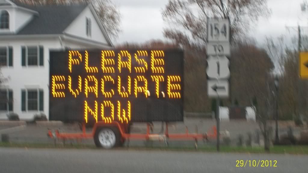
Did a little cruising along Route 1/156 between Madison and Ocean Beach, New London, CT facing Long Island Sound (near Long Island, NY): A LOT of people have boarded up shore facing homes. Many areas were abuzz in activity, some areas in the Lymes and Westbrook seemed to be packing their autos with things from their homes, and perhaps they are not staying? Not sure.
I saw the evacuations in part of New London, East Lyme, and Waterford. As I made my way down 156 in Old Saybrook it was really eerie; There were school buses driving down all the side streets and people appeared to be getting on. NEVER SAW ANYTHING LIKE THIS IN 20 years down here. A bit unnerving. As I turned corner say police and signs directing people away from the coast:
They are expecting locations less than 11 feet above MSL down here to go under water.
It's snowing lightly in central northern Ireland according to the radar.
I guess I was right .
Obviously just a blip on the radar
Quote:
Originally Posted by owenc
Yes noticed that. Bat of a sister put on a pic last night. I knew it was to wind me up.
We did get snow but all of out showers fell when it was above freezing. Now it's frozen solid ice. My deck is awful.
Funny how you are the only person in Northern Ireland to report seeing any snow...
Quote:
Originally Posted by owenc
I guess me and you both need an apology from that boy in Portsmouth!
I said it wouldn't snow in Northern Ireland & it didn't. I originally said only higher ground in Scotland & northern England would see snow, which was correct based on the current GFS runs etc.. BUT when those runs upgraded the chances of snow I mentioned this, adding that eastern parts of England could also see snow, which they did. So no apology needed from me
Oh & I'm not a 'boy'
Quote:
Originally Posted by dunno what to put here
Even coastal England had snow cover! 11cm in parts of north east England.
Yes the Newcastle area got a fair bit...
Anyway down here no snow of course, not even any frost. Low Friday night was 3.3C & Saturday night was 3.5C. Daytimes highs have still been over 10C too (Friday 11.4C, Saturday 10.9C & Sunday 10.8C)Looking much more unsettled next week still, with milder temperatures & plenty of wet & windy weather...
Please register to post and access all features of our very popular forum. It is free and quick. Over $68,000 in prizes has already been given out to active posters on our forum. Additional giveaways are planned.
Detailed information about all U.S. cities, counties, and zip codes on our site: City-data.com.

 Please register to participate in our discussions with 2 million other members - it's free and quick! Some forums can only be seen by registered members. After you create your account, you'll be able to customize options and access all our 15,000 new posts/day with fewer ads.


 the dodgy unofficial total for here is 47.5 but considering Heathrow is on 76.7 I suspect the official Hampstead running total is around 60-65, with no more than five more predicted for the last three days. It's probably one of the lowest in the country - Tiree is the highest I could find on 116.1 hours, which shows how topsy-turvy it has been.
 .
.


