Please register to participate in our discussions with 2 million other members - it's free and quick! Some forums can only be seen by registered members. After you create your account, you'll be able to customize options and access all our 15,000 new posts/day with fewer ads.
We should rename this thread "fall thread for North America".
This site was originally for American city data, so not surprising. It's like complaining that a weather thread on a UK forum talks about the UK weather all the time...
Pretty cool weather today for Mississippi. Low 60s (same as here!), and only 68 in New Orleans. Looks like it's a straight shot down to the coast. Northern winds perhaps? Shreveport is at 78 and Montgomery, AL at 85.
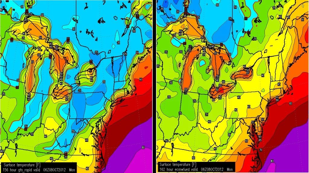
Here guys... You decide. If you were putting a forecast together which would you believe for this exact time frame of October 8th? GFS or Euro? This isnt made up. This is from the latest runs.
GFS showing widespread 20s Euro showing widespread 40s.
This is why you have to respect NWS forecasters. They have to use skill, experience, and a whole bunch of other factors when putting a long range forecast together.
Which would you choose at this point?
I tend to doubt that you would see 20's in early October even in the upper Northeast (Northern NY, VT, NH, ME...etc)....so I would go with a blend, maybe lower 30's to mid 40's north to south.
However, if the GFS is right, and looking at the map...look at the difference in NY between northern NY (25 F) and eastern Long island (60 F). A 45 F difference in less than 250 miles!!!.
In regards to the Northern Plains-Minnesota storm... model data in late this evening...shows the NAM model with a strong low and snow band over northeast North Dakota into Manitoba...while GFS run hardly anything....with any precipitation well to the east with a weaker low. Sigh glad I am not forecasting overnight
Does anyone know about this Typhoon recurve he's talking about?
Looks like there is a definite correlation between a recuring typhoon and weather in NorthAmerica. Some NWS locations mentioned it in their discussion. Here's HPC mentioning it.
It apprently enhances a ridge in the west, hence why the East will get cold with the trough digging down next week.
THIS ENSEMBLE MEAN ALONG WITH THE GEFS/NAEFS MEANS OFFER A LITTLE MORE
MID-UPPER LEVEL TROUGH AMPLITIDE/DIGGING THAN CORRESPONDING
DETERMINISTIC RUNS OVER THE CENTRAL US BY THEN THAT SEEMS
REASONABLE CONSIDERING UPSTREAM RIDGE AMPLITTUDE IS EXPECTED TO
REMAIN ENHANCED WITH APPROACH OF SEVERAL PAC SYSTEMS FORMERLY OF
TROPICAL ORIGIN AS TYPHOONS.
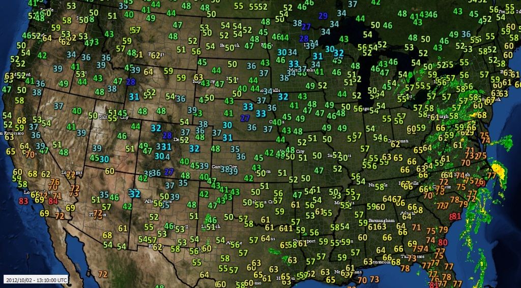
U.S Temps as of 9amEST October 2, 2012. Look how far down the 30s go (0-5C). The coasts all around the U.S stays warm. Southern California continues to melt. Remember, its 6am here with these temps.
I checked Nebraska's normal low temp and its mostly 40s now. So they are below normal in some spots. This is just the beginning too, should be interesting to see how low temps go by end of week..
Please register to post and access all features of our very popular forum. It is free and quick. Over $68,000 in prizes has already been given out to active posters on our forum. Additional giveaways are planned.
Detailed information about all U.S. cities, counties, and zip codes on our site: City-data.com.

 Please register to participate in our discussions with 2 million other members - it's free and quick! Some forums can only be seen by registered members. After you create your account, you'll be able to customize options and access all our 15,000 new posts/day with fewer ads.