Please register to participate in our discussions with 2 million other members - it's free and quick! Some forums can only be seen by registered members. After you create your account, you'll be able to customize options and access all our 15,000 new posts/day with fewer ads.
Atlanta would be considered warm continental under your scheme too. Sure, the name doesn't matter much, but I don't see Memphis and Atlanta being in the same climate as Indianapolis and Columbus. If you want subtropical to mean what you meant, then the warm continental should be 0-7C instead of -3-5C.
I don't know much about vegetation, but generally the former two are definitely associated with the rest of the South. USDA hardiness zone shows them to be in zone 7b, which is standard for the Mid-South. That zone is 3-4 zones warmer than Indianapolis and Columbus. Deep South is 8a or higher.
Hmm. 7b doesn't seem that mild to me. I grew up in Long Island which was 7a and the winters were severe enough to halt all plant growth for at least 4-5 months, so I don't think anything zone 7 deserves to be in my subtropical category. There's always going to be conflicts, but I wanted my humid subtropical climate (or whatever the best name is) to have milder winters, maybe just deep south then.
Hmm. 7b doesn't seem that mild to me. I grew up in Long Island which was 7a and the winters were severe enough to halt all plant growth for at least 4-5 months, so I don't think anything zone 7 deserves to be in my subtropical category. There's always going to be conflicts, but I wanted my humid subtropical climate (or whatever the best name is) to have milder winters, maybe just deep south then.
Looks like my current location is 6a, right on the border with 5b.
That's fine. I just think 0-7C would be a better zone for warm continental than -3-5C. With the 0C isotherm, it separates the climates that get regular snow from those that don't. The lying snow phenomenon and long, snowy winters are more associated with Dfb climates than Dfa anyway.
That's fine. I just think 0-7C would be a better zone for warm continental than -3-5C. With the 0C isotherm, it separates the climates that get regular snow from those that don't. The lying snow phenomenon and long, snowy winters are more associated with Dfb climates than Dfa anyway.
I think -3°C is the better snow isotherm than 0°C. Coming from Long Island (at around 0°C) back to Massachusetts (-4°C) the difference is stark. The former gets snow occasionally most winters, the latter has snow on the ground most winters. Patricius Maximus would strong agree.
Using the 0°C thershold would create a chunk of Dfa climate between my "humid continental" and Dfb (my town is almost on the border between Dfa / Dfb and with the -3°C boundary the Dfa would almost disappear from New England and it would go straight from "humid continental" to Dfb) but would remove the "Cold Oceanic" climate from New England, which is a plus. It's not a great idea to create a climate classification based on one small region of the country. Pluses and minus for both ideas. Don't really want to quibble with a few degrees, the borderline climates will always be arguable.
But going up from Long Island or the mid-Atlantic, there's only one vegetation change going into interior New England, so the intermediate climate Dfa zone isn't really reflected. There's another vegetation change in far Northern New England, but then we're getting super specific.
Thinking of a way to classify the "temperate climates" without cold winters (similar to Koppen C) I'd do a 4 way classification. First division would be those that have no month colder than about 7°C. These would have only occasional frost, able to support a large variety of plant life and not have winters cold enough to truly change usual outdoor activities and habits. They are no tropical because some months are noticeably different from the hottest season and there are some frosts — a tropical climate requires constant heat, the 18°C threshold for every month Koppen uses is about what to me would be summer-like, and is close to the requirements of some tropical plants so I'd Koppen's border.
Then I divide uses Koppen's thershold for hot summers — warmest month > 22°C. This to prevent a climate like this from getting a subtropical designation. Since I've already divided the C climates by winters, there are no issues with grouping the climates with the coldest winters with the rest of the C climates. I keep Koppen's -3°C winter boundary for C climates since that fits closer with the line of winterlong snow.So,
Then the usual dry winter, dry summer subtypes, the "humid subtropical" name obviously changes for the dry summer subtype. For D climates with mean winter temperatures < -3°C I'd use Koppen's classification, though for New England it produces odd results, "warm continental", "cold oceanic", Dfa (maybe not with the -3°C threshold), and Dfb would all occur within 100 miles of each other.
The warm oceanic climates are a mild climate lovers' paradise. My system allows one to pick them out easily, and their plant growth and weather patterns are usually quite different from the hot summer subtypes. In much of the world, the warm oceanic climates have a dry summer, with the southern hemisphere being the biggest exception. Personally, my ideal is a climate straddling the boundary between warm oceanic and humid subtropical.
I like the idea of this system. Warm Oceanic is actual climate category imo, quite distinct from Cold Oceanic climates, as shown by obvious physical differences during the coldest months. Having the label Subtropical, isn't important because these climates have the advantage of being able to successfully grow a large range of temperate plants, as well as subtropical ones. They are more transitional than subtropical climates.
One change I could think of, would be to include a Cool Oceanic group, of winters colder than 7C, but warmer than about 2C that would include a lot of the current Cfb climates such as the PNW, and Western Europe.
Even though I prefer to use Köppen and I love living in the Humid Subtropical climate ...I'd have to choose neither...although I do admire Trewartha's additional letter system.
The reason why I choose neither is that when it comes to the humid subtropical/continental issue both Köppen's "Cfa" and Trewartha's "D" climates are equally as broad, but I find it interesting that a broader "Dfa" classification seems to be less controversial than the current "Cfa" classification, I think this is fueled by the perception of northern Cfa cities being ice boxes, most would probably find it easier to associate NYC with Minneapolis than Tallahassee when NYC is roughly equidistant between the two temperature-wise in January. This is one reason why I don't agree with the notion of slicing "Cfa" in half and incorporating the northern portion with "Dfa", the freeze line/persistent snow line is another reason.
I'd modify Köppen's classification by adding a new climate classification that lies between "C" & "D". The persistent snow line (-3°C) would be used for the northern boundary and Trewartha's 8 (or 9)-months-above-10°C rule would be used for the southern boundary. I have to give it more thought though since this is pretty Eastern U.S.-centric, I don't know how it would work on different continents.
I think -3°C is the better snow isotherm than 0°C. Coming from Long Island (at around 0°C) back to Massachusetts (-4°C) the difference is stark. The former gets snow occasionally most winters, the latter has snow on the ground most winters. Patricius Maximus would strong agree.
But going up from Long Island or the mid-Atlantic, there's only one vegetation change going into interior New England, so the intermediate climate Dfa zone isn't really reflected. There's another vegetation change in far Northern New England, but then we're getting super specific.
That “stark” line you speak of and even the vegetation change is really what has always been the most interesting to me about all this. I guess the debate about what to call a climate zone will go on forever - but where these broad climate lines are (geographically), and where/when the differences in these climate zones can be observed - seems far more important and interesting. In fact, according to both Koppen (the C/D line) and Trewartha (the Dca/Dcb line) your current location in Massachusetts straddles one of these climate change lines:
One of the things I have always enjoyed about living along the East Coast of the USA/Canada – is that one can travel from climates that are near boreal/E (in southeastern Quebec) to climates that are tropical/A (in deep South Florida) by auto and observe interesting changes: In winter - as one travels southward, the change in wardrobe becomes as obvious as the change in vegetation/environment as you reduce your latitude. It can be interesting to try to pick out (and it is not always the same every year) where these broad climate lines/transition zones are. This is another reason I favor the Trewartha system – it seems (roughly) to have accurate placed the broad climate lines in the right spot (based on vegetation):
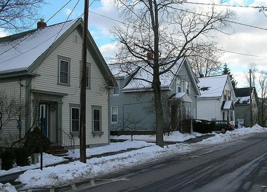
If you start in the Dcb (temperate contential - cool summer/severe winter zone) which runs from Massachusetts into southern Canada , there really seems to be not much difference in the winter look across the region in terms of landscape and plant life: There is frequently a snowcover, nearly all plants are dormant, there are many conifers (needle) trees and shrubs used in landscaping, and few broadleaf evergreens. This is a picture I took some years back in New Hampshire in winter. I think it is pretty typical of the average look of winter anywhere from southern Quebec through Massachusetts:
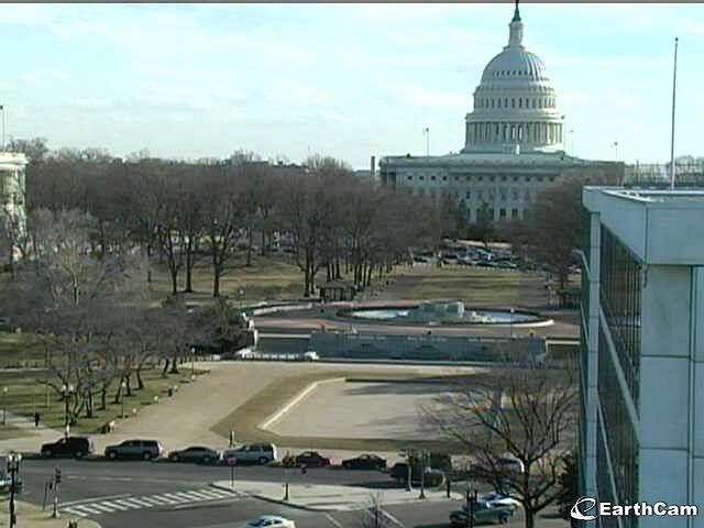
As you cross the Dcb/Dca line (Trewartha separates them by using 22 C/72 F for the warmest month) somewhere in southern Massachusetts/southern NY/PA/Ohio… (see map above)….the winter landscape (again on average) changes in noticeable way: As you move southward from Massachusetts toward southern Connecticut/NYC, there is often little or no snowcover(you are now getting near that 0 C/32 F coldest month line), there are fewer wild confiners in the forests, not all of the vegetation/plant life is dormant, you see more broadleaf evergreens (rhododendron, ilex, boxwood, LLM,…etc). Below is a picture in mid winter near the State Capitol building in Washington DC, there is no snow on the ground, the grass is semi-green. Also, here is a picture I took along Long Island Sound (Connecticut side) showing some of the wild broadleaf evergreens that grow. This seems pretty typical of ground cover from Long island south to southern Virginia:
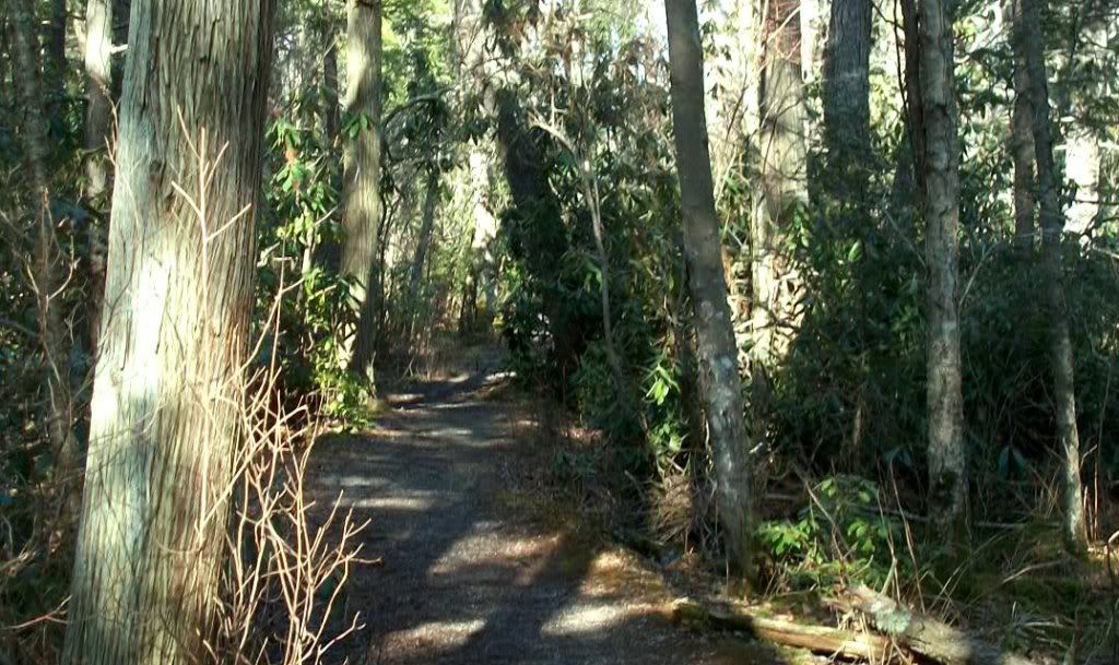
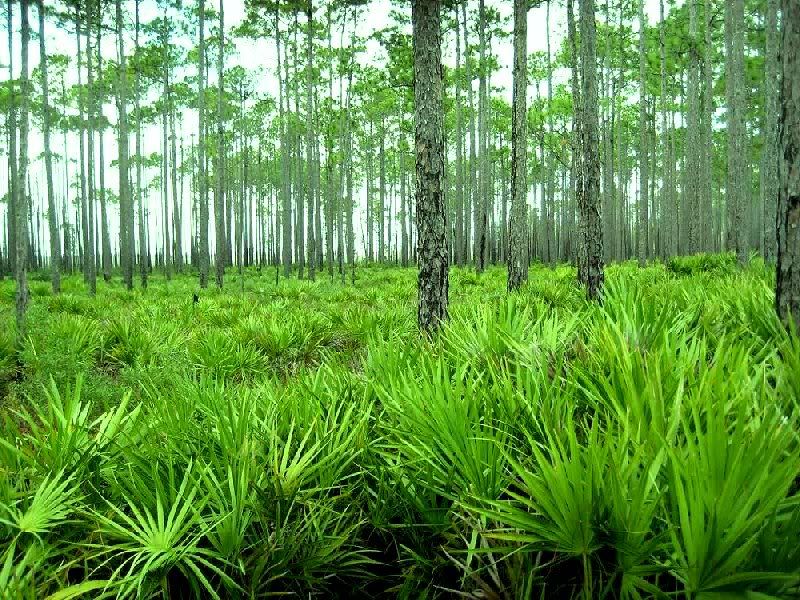
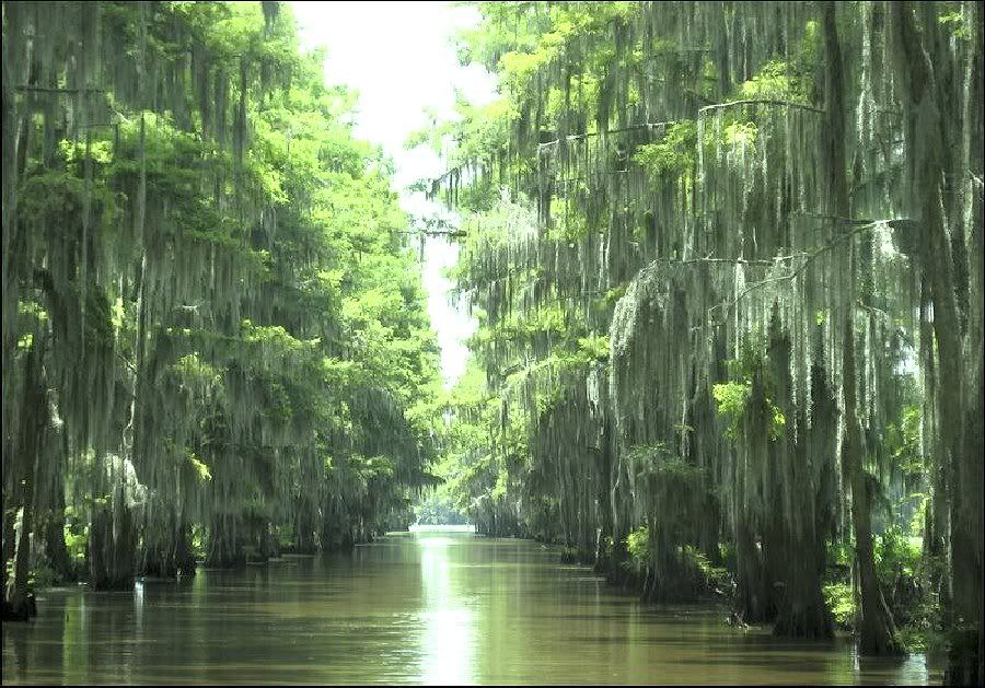
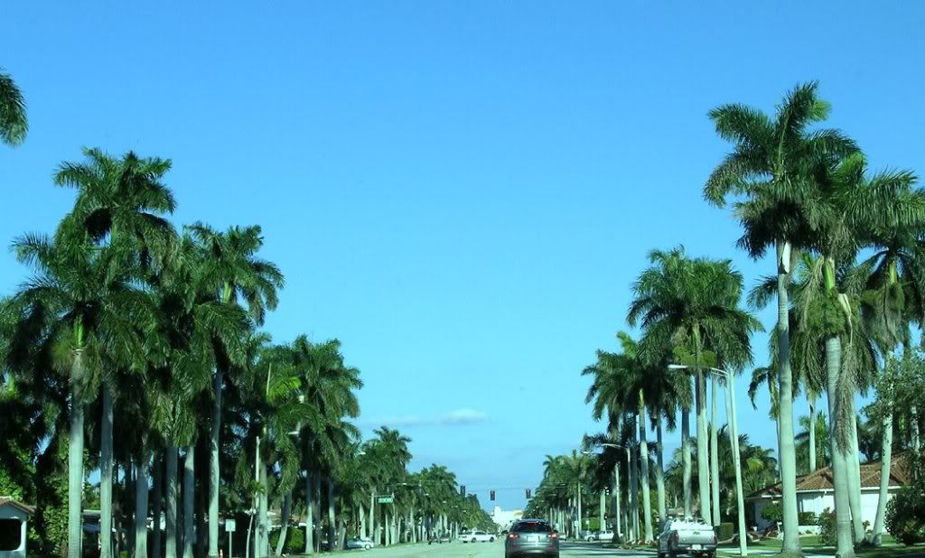
As you cross through central North Carolina and approach the South Carolina state line, you are crossing into Cfa climate (subtropical). Trewartha actually placed the line about 200 miles too far north it seems (in northern NC). As you move southward into south Carolina and Georgia you notice another change in vegetation; The temperate/middle latitude look of winter gives way now to wild palms/saw palmetto along the highway and in the edges of the tidal marshes, the grass (wild as well as cultivated) becomes all green, Spanish moss hangs from the trees (many trees like Magnolia/Live Oak are evergreen), and the land is flatter and almost looks more savanna (at least along the East Coast). Also, different species of animals and reptiles start to appear. By the time you make your way south through northern Florida, the landscape has become nearly all evergreen, the typical vegetation is mostly palms, scrub palms, bald Cyprus in the cannels, …etc:
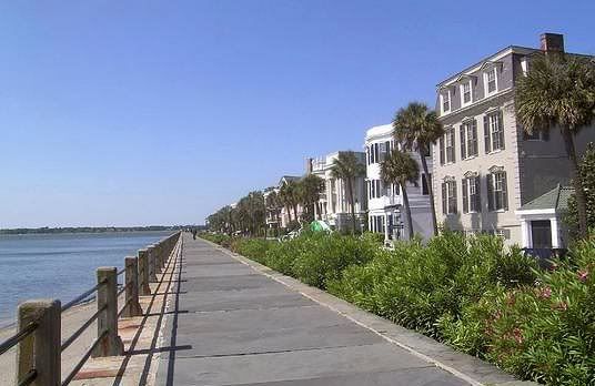
I took these pics in South Carolina off I-95 in February:
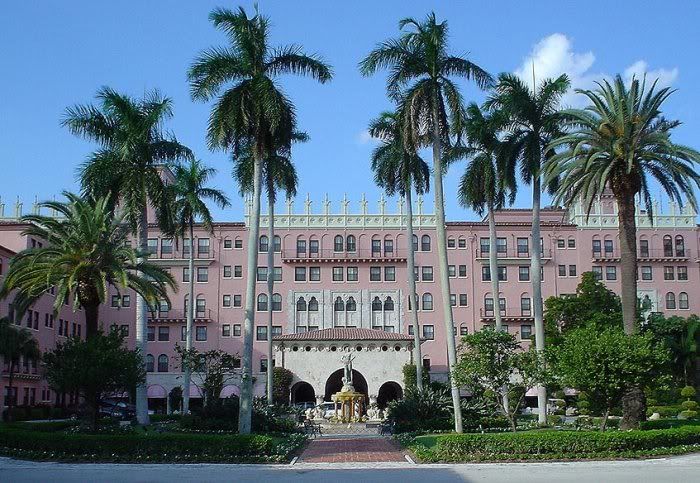
Charleston:
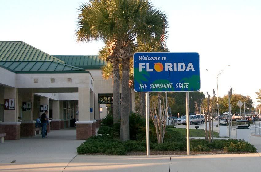
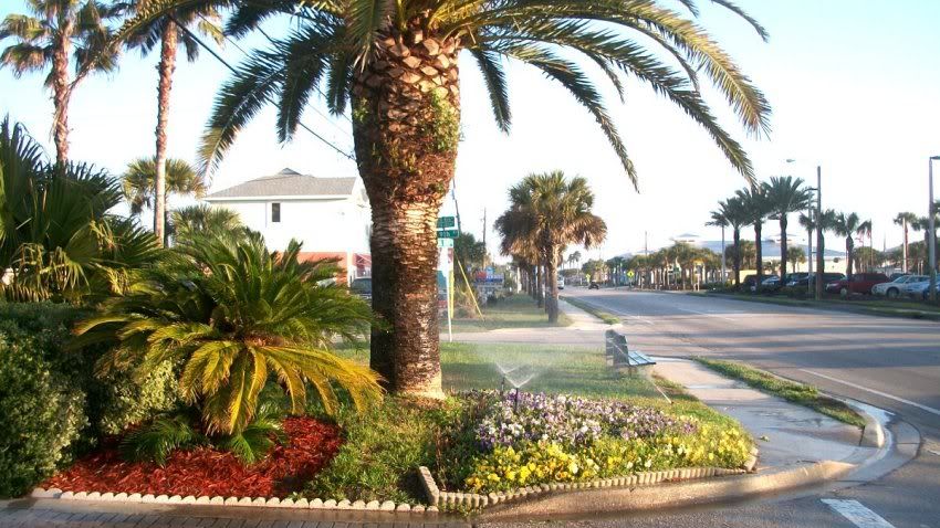
Into North Florida. Notice that both the natural and cultivated landscapes have turned mostly green:
St. Augustine in Feb:
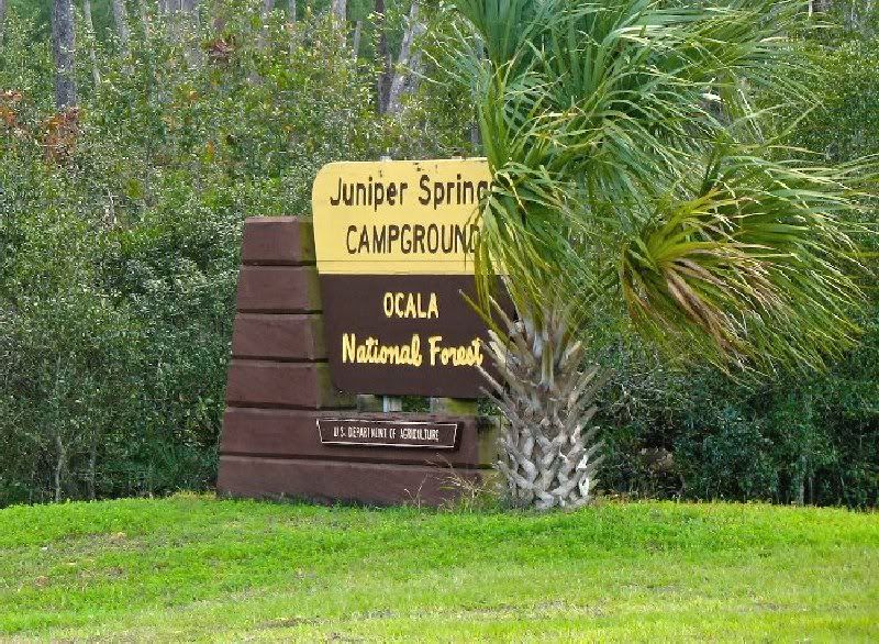
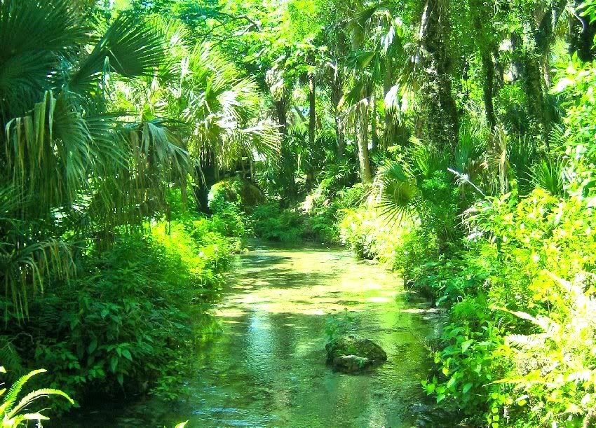
As you cross through south - central Florida, you sense that you are approaching another climate line. Somewhere around Ft. Lauderdale/Jupiter…etc, Trewartha placed is C (subtropical) and A (tropical) boundary. In terms of the local vegetation, you can slowly see this change – the landscape where it is wild becomes mostly savanna/scrub palms, wild palms, broadleaf evergreens, in cultivated areas the palms have become more Royal palms- with coconut, paurotis, queen palms…etc being observed everywhere. The envormanent actually looks wetter and lusher than the subtropical areas from north Florida through South Carolina. You are in a location now that really has an endless summer, with little change in vegetation throughout the year:
So when you look at Trewatha’s map (at least to me), he seems to have done a farily good job at placing his Dfa/Dfb line….his C/D line…and his C/A line along the East Coast.
.
Last edited by wavehunter007; 08-22-2012 at 10:06 AM..
I find it interesting that the PNW in winter resembles most closely your pics of washington dc and long island. I guess that has to do south the fact that winter averages are very similar.
As you cross through central North Carolina and approach the South Carolina state line, you are crossing into Cfa climate (subtropical). Trewartha actually placed the line about 200 miles too far north it seems (in northern NC). As you move southward into south Carolina and Georgia you notice another change in vegetation; The temperate/middle latitude look of winter gives way now to wild palms/saw palmetto along the highway and in the edges of the tidal marshes, the grass (wild as well as cultivated) becomes all green, Spanish moss hangs from the trees (many trees like Magnolia/Live Oak are evergreen), and the land is flatter and almost looks more savanna (at least along the East Coast). Also, different species of animals and reptiles start to appear. By the time you make your way south through northern Florida, the landscape has become nearly all evergreen, the typical vegetation is mostly palms, scrub palms, bald Cyprus in the cannels, …etc:
Good post...
That was the vegetation change I wanted to capture between my "subtropical" and "warm continental" category. Do you think my 7°C threshold is closer to the vegetation transition. Certainly, I'd want those Carolina spots to be in a different climate category than the mid-Atlantic. The one issue is that while Trewartha (or my) classification goes well with the Eastern and Midwestern North America, does it work well with vegetation in other parts of the world? It's easy to draw your line to fit exactly the place you live in, but there's the danger it might non-applicable elsewhere. I think my system does a decent job separating perceptions of different types of winter (or non-winters depending on your perspective) but vegetation-wise are the separation meaningful elsewhere. The southern Hemisphere doesn't have any "Warm Continental", the other big mass of it would be in East Asia, and maybe a few spots in Europe. Would be interesting to check if there's a vegetation change in East Asia around the same boundaries.
Please register to post and access all features of our very popular forum. It is free and quick. Over $68,000 in prizes has already been given out to active posters on our forum. Additional giveaways are planned.
Detailed information about all U.S. cities, counties, and zip codes on our site: City-data.com.

 Please register to participate in our discussions with 2 million other members - it's free and quick! Some forums can only be seen by registered members. After you create your account, you'll be able to customize options and access all our 15,000 new posts/day with fewer ads.


 ...I'd have to choose neither...although I do admire Trewartha's additional letter system.