Please register to participate in our discussions with 2 million other members - it's free and quick! Some forums can only be seen by registered members. After you create your account, you'll be able to customize options and access all our 15,000 new posts/day with fewer ads.
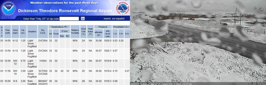
When you enter the site, you will need to click on webcams on the left menu to see the icons, and then you can click on the little camera icons to see pictures.
--Dan
yes, forgot I had that, thanks! Here's how it looks in Dickinson, ND.
During November, it is not uncommon for powerful storms to track northeast across the Great Lakes region. Building arctic air masses across Alaska and Canada surge southeast into the Rockies and Plains States more frequently. At the same time, the still very warm waters of the Gulf of Mexico provide a source of heat and considerable moisture to fuel the development of low pressure systems riding the leading edge of the arctic air masses. These low pressure systems frequently organize in the lee of the central and southern U.S. Rocky Mountains. As the low pressure systems strengthen, they ride the jet stream northeast into the Great Lakes region. The relatively warm waters of the Great Lakes can cause these storms to intensify more than they might otherwise.
Even at the turn of the century 100 years ago, November was documented to be a month that produced strong storms over the Great Lakes region, posing a significant danger to shipping. In a paper published in a 1903 Weather Bureau Bulletin (in the early 1900s,
The November 9-10, 1975, storm caused the sinking of the Edmund Fitzgerald on Lake Superior. The November 9-11, 1998, storm is discussed since it occurred on the same days in November, followed nearly the same track, and was more intense than the ‘75 storm.
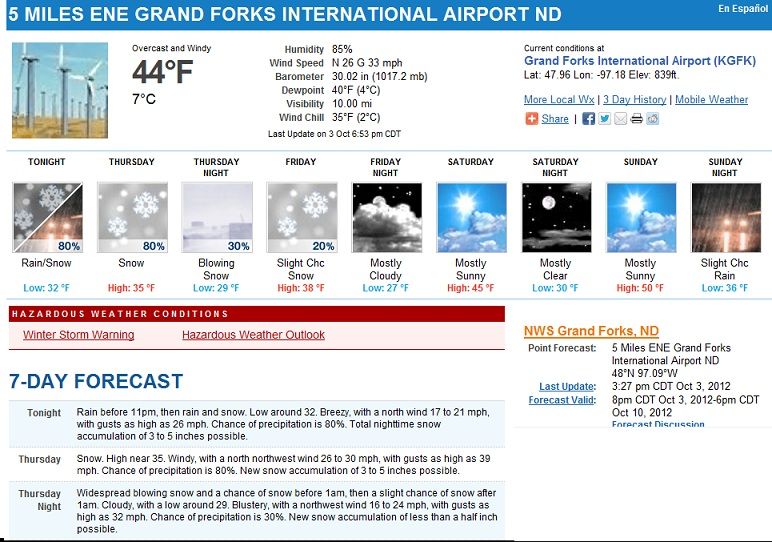
THE POTENTIAL EXISTS FOR 6 TO 10 INCHES IN THE NORTHERN RED RIVER VALLEY AND 10
TO 12 INCHES ACROSS PORTIONS OF NORTHWEST MINNESOTA.
THE NATIONAL WEATHER SERVICE IN GRAND FORKS HAS ISSUED A WINTER
STORM WARNING FOR HEAVY SNOW AND BLOWING SNOW...WHICH IS IN EFFECT
FROM 1 AM THURSDAY TO 10 AM CDT FRIDAY. THE WINTER STORM WATCH IS
NO LONGER IN EFFECT.
* TIMING...RAIN IS EXPECTED TO CHANGE TO SNOW ON THURSDAY
MORNING...AND CONTINUE INTO FRIDAY MORNING. THE SNOW MAY BE
HEAVY AT TIMES.
* WINDS...NORTH WINDS WILL INCREASE ON THURSDAY AND BECOME 20 TO
30 MPH WITH HIGHER GUSTS...CONTINUING INTO EARLY FRIDAY MORNING.
* VISIBILITIES...MAY BE NEAR ZERO WITHIN FALLING AND BLOWING
SNOW. * SNOW ACCUMULATIONS...10 TO 12 INCHES ARE POSSIBLE.
* WIND CHILL VALUES...IN THE MID TO UPPER TEENS.
* OTHER IMPACTS...HEAVY SNOW ON TREE BRANCHES AND POWER LINES MAY CAUSE THEM TO BREAK.
I can't ever remember Dakota or Minnesota getting a foot of snow in early October. I don't have the memory of a 90-year-old veteran observer, but I'm sure it's very rare in those parts to get 10-12 inches this early in the year.
I havent seen a snow total higher than 3.5" yet.. Maybe later as this thing intensifys.
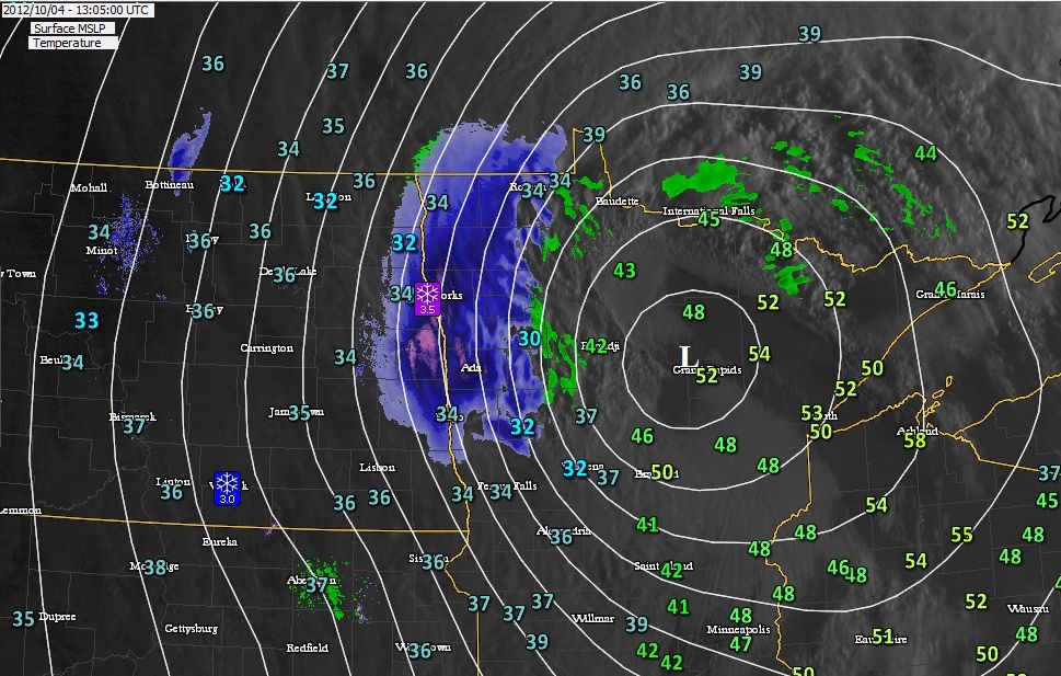
From HPC:
...A RAPIDLY INTENSIFYING STORM IS EXPECTED TO BRING A PERIOD OF
SNOW ALONG WITH STRONG GUSTY WINDS IN NORTHWESTERN MINNESOTA
TODAY...
A LOW PRESSURE CENTER IS INTENSIFYING RAPIDLY AS IT TRAVERSES
NORTHEASTWARD ALONG A FRONTAL BOUNDARY ACROSS MINNESOTA EARLY THIS
THURSDAY MORNING. AS THE INTENSIFYING STORM PULLS IN COLDER AIR
FROM CANADA...RAIN IS EXPECTED TO CHANGE OVER TO SNOW FROM WEST TO
EAST ACROSS NORTHERN MINNESOTA TODAY. IN THE MEAN
TIME...NORTHWEST WINDS WILL ALSO INCREASE SIGNIFICANTLY DURING THE
DAY TODAY AND THEY WILL BECOME VERY GUSTY.
THE STORM IS EXPECTED TO REACH PEAK INTENSITY TONIGHT AS IT MOVES INTO SOUTHWESTERN ONTARIO IN CANADA. ALTHOUGH THE BULK OF THE SNOW ASSOCIATED WITH
THE STORM SHOULD FALL IN CANADA...A PERIOD OF SNOW ALONG WITH
STRONG GUSTY WINDS CAN BE EXPECTED DURING THE DAY TODAY NEAR THE
U.S.-CANADIAN BORDER OF MINNESOTA. THE SNOW IS EXPECTED TO TAPER
OFF TONIGHT AS THE LOW MOVES A BIT FARTHER INTO ONTARIO AND BEGINS
TO WEAKEN. HOWEVER...SOME LIGHT SNOW AND SNOW SHOWERS WILL LINGER
ACROSS NORTHERN MINNESOTA AND LAKE SUPERIOR THROUGH FRIDAY AS THE
LOW WEAKENS TO A SURFACE TROUGH OF LOW PRESSURE
I can't ever remember Dakota or Minnesota getting a foot of snow in early October. I don't have the memory of a 90-year-old veteran observer, but I'm sure it's very rare in those parts to get 10-12 inches this early in the year.
You don't have to go back 90 years ago...it occurred just 7 years ago
From: Vivian Sprynczynatyk
To: undisclosed-recipients:
Sent: Saturday, October 08, 2005 8:26 PM
Subject: ND Blizzard
WEATHER BULLETIN
"Up here in the Northern Plains we just recovered from a Historic --- may I even say a "Weather Event" of "Biblical Proportions" with a historic blizzard of up to 24" inches of snow and winds to 50 MPH that broke trees in half, stranded hundreds of motorist in lethal snow banks, closed all roads, isolated scores of communities and cut power to 10's of thousands.
George Bush did not come....FEMA staged nothing....no one howled for the government...no one even uttered an expletive on TV...nobody demanded $2,000 debit cards.....no one asked for a FEMA Trailer House....no news anchors moved in.
We just melted snow for water, sent out caravans to pluck people out of snow engulfed cars, fired up wood stoves, broke out coal oil lanterns or Aladdin lamps and put on an extra layer of clothes.
Even though a Category "5" blizzard of this scale has never fallen this early...we know it can happen and how to deal with it ourselves. Everybody is fine".
This is not New Jersey or Nevada....this the upper Midwest remember...
Good video of the 2005 Storm here...Notice the very last slide... Grand Forks, ND only got 2". So today could be historic for them. Have to see the final totals.
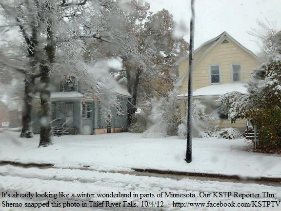
I tell you, I was watching the radar and there looked to be heavy snow bands right over this area but the picture isnt impressive. Either it was taken before it or melting was substantial. Maybe thats why we're not seeing more than 5" totals. I believe this area had 3.5" total so far. Maybe 2 melted.
Please register to post and access all features of our very popular forum. It is free and quick. Over $68,000 in prizes has already been given out to active posters on our forum. Additional giveaways are planned.
Detailed information about all U.S. cities, counties, and zip codes on our site: City-data.com.

 Please register to participate in our discussions with 2 million other members - it's free and quick! Some forums can only be seen by registered members. After you create your account, you'll be able to customize options and access all our 15,000 new posts/day with fewer ads.