Please register to participate in our discussions with 2 million other members - it's free and quick! Some forums can only be seen by registered members. After you create your account, you'll be able to customize options and access all our 15,000 new posts/day with fewer ads.
Just starting my end of year vacation and have my fingers crossed for the upcoming winter events....I will be in Wv,and western md until Jan2nd...I have a feeling the next 2 weeks will be interesting and will finally kick off "winter"!
Temps and Radar across the NorthEast. NWS Boston explains the lack of precip down below and the CAD which didnt work out for parts of CT as its above freezing across the state.
CONTINUED TO ADJUST FORECAST TO ACCOUNT FOR CURRENT
CONDITIONS AS FORECAST CONTINUES TO BE A TAD COOLER. WINDS ARE
MAINLY OUT OF THE NE BUT ARE EXPECTED TO TRANSITIONS MORE TO THE
EAST LATER THIS AFTERNOON. OTHERWISE FORECAST REMAINS ON TRACK FOR
THE NEXT FEW HOURS.
THIS MORNING... TRICKY FORECAST FOR THIS MORNING AS IT APPEARS THERE
IS JUST NOT ENOUGH LIFT AND TO MUCH DRY AIR TO MAINTAIN ANY PRECIP
ACROSS THE AREA. HOWEVER AS THE WINDS TURN MORE EASTERLY...EXPECT
MORE MOISTURE TO MOVE INTO THE REGION TO BEGIN TO MOISTEN UP THE
COLUMN. APPEARS THE BETTER LIFT WILL OCCUR BY THE AFTERNOON HOURSPER LATEST 00Z MODEL GUIDANCE.
TEMPORARIES FOR THIS MORNING ARE WARMER THEN ORIGINALLY THOUGHT...SO THE COLD AIR DAMMING SCENARIO DID NO PAN OUT SO WELL ESP ACROSS CT/AND SOUTHERN MASS. THIS
IMPACTED THE CHANCE FOR WINTRY PRECIP FOR SAID REGIONS EARLY THIS
MORNING. CURRENTLY THINK THAT AS THE COLUMN MOISTENS THERE WILL BE
ISOLATES SNOW SHOWERS ACROSS WESTERN MASS AND IN NH, WHILE CLOSER
TO THE MASS PIKE A WINTRY MIX WILL OCCUR.
KEEP IN MIND THIS WILL BE ISOLATED AS THERE IS NOT ENOUGH SUPPORT IN THE ATMOSPHERE.
The local NWS is talking a little more about next weeks storm. If that cold air can dig a little deeper it sounds like we'll set up for a decent storm system. Keep your fingers crossed.
.
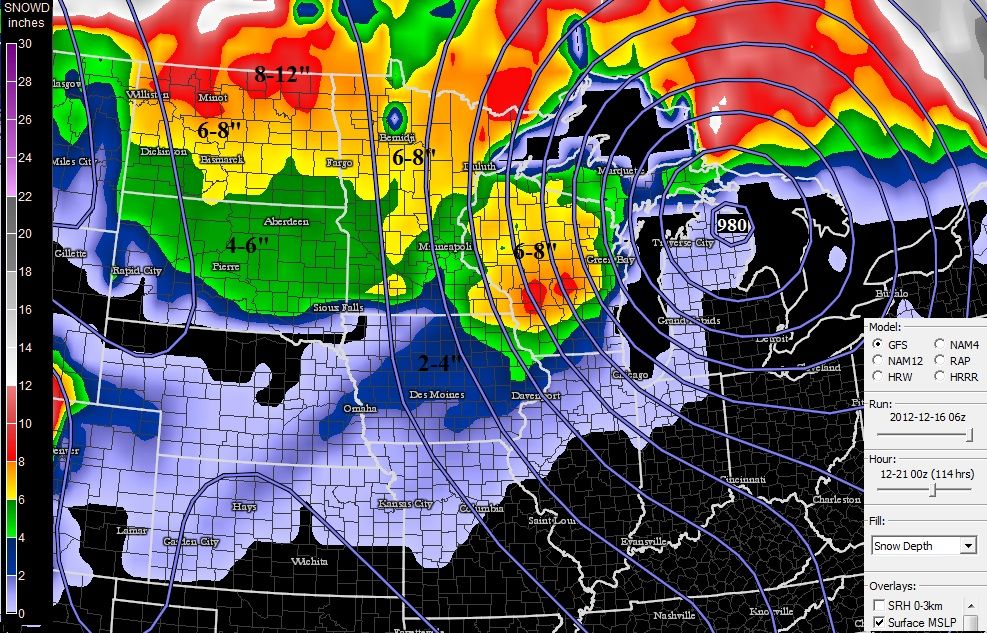
If this next storm track holds there will be a good snowfall over larger area of Mid West in 4 days.
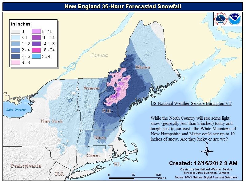
From NWS next 36hrs "While the North Country will see some light snow (generally less than 2 inches) today and tonight,just to our east...the White Mountains of New Hampshire and Maine could see up to 10 inches of snow. Are they lucky or are we?"
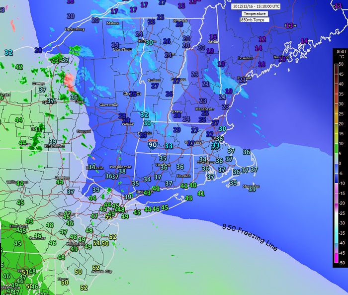
At 10am the 850 feezing line holding firm but surface temps and thickness not condusive for wintry weather south of I-90 even though its only in the 30s in CT the thickness is too warm. North of CT different story holding in the 20s and low 30s.
From a meteo friend of mine.. Explains it very well!
"The low-level cold air damming will be tough to scour out. This was a classic case that cold air was building in at the low-levels at the same time warm air was moving in in the mid-levels. In this case, cold air will always win at the low-levels...at least to start. The problem was for moisture...the cold air was TOO strong and dry and there has been nothing but virga!"
Please register to post and access all features of our very popular forum. It is free and quick. Over $68,000 in prizes has already been given out to active posters on our forum. Additional giveaways are planned.
Detailed information about all U.S. cities, counties, and zip codes on our site: City-data.com.

 Please register to participate in our discussions with 2 million other members - it's free and quick! Some forums can only be seen by registered members. After you create your account, you'll be able to customize options and access all our 15,000 new posts/day with fewer ads.