Please register to participate in our discussions with 2 million other members - it's free and quick! Some forums can only be seen by registered members. After you create your account, you'll be able to customize options and access all our 15,000 new posts/day with fewer ads.
Remember... Upper Level lows is a cold vortex above spinning and spinning. You will always be below normal underneath them. In the winter they provide fridgid air and tons of snows. And to my surprise in late Spring as well.
RECORD EVENT REPORT
NATIONAL WEATHER SERVICE FORT WORTH TX
753 AM CDT FRI MAY 03 2013
...RECORD LOW TEMPERATURE SET AT DALLAS FORT WORTH...
THE LOW TEMPERATURE THIS MORNING AT DALLAS FORT WORTH INTERNATIONAL
AIRPORT WAS 39 DEGREES. THIS BROKE THE OLD RECORD FOR MAY 3RD OF 41
DEGREES SET IN 1954.
RECORD EVENT REPORT
NATIONAL WEATHER SERVICE SHREVEPORT LA
830 AM CDT FRI MAY 3 2013
...DAILY LOW TEMPERATURE RECORD TIED OR BROKEN FOR MAY 3RD...
LOCATION OLD RECORD NEW RECORD YEARS OF DATA
------------------------------------------------------------------
SHREVEPORT LA 47 IN 1911 41 IN 2013 RECORDS SINCE 1874
MONROE LA 47 IN 1960 46 IN 2013 RECORDS SINCE 1930
TYLER TX 42 IN 1967 41 IN 2013 RECORDS SINCE 1896
------------------------------------------------------------------
THE SHREVEPORT RECORD LOW FOR MAY 3RD BREAKS THE ALL TIME RECORD LOW
OF 42 FOR THE MONTH OF MAY. THIS NEW RECORD LOW IS IN JEOPARDY OF
BEING BROKEN AS THE SHREVEPORT LOW FOR MAY 4TH IS FORECAST FOR NEAR
40.
Thanks to PM and a couple others for staying on top of this whole event since last week and beyond.
So all in All the Euro will end up being right with the location of the Upper Low from original solutions before going too far west and north.. It actually did better with the ULL from 7-10 days out then 4-6 days out. The ULL is Currently heading towards the gulf states. GFS was horrible like usual but then it came around like usual.
Looking back at some files I realized the Euro was dead on with the snow locations even into NW Arkansas. Thats prety damn impressive for 5-7 days before...in May
Posted April 28 from Euro. I specifically pointed out Kansas and Des Moines data showing how cold it got and the moisture thats around. But look at the snow totals. Impressive! http://www.city-data.com/forum/29327379-post1316.html
This has to be the coldest day in May I have ever experienced. Temperatures have been steady in the lower 40s for most of the day with moderate to heavy rain which is finally tapering off. The low tonight should be around 37, so there's a good chance we'll break the all time May record low of 38.
Wavehunter has already taken enough flak. It should suffice to say he made a call and it was the wrong one.
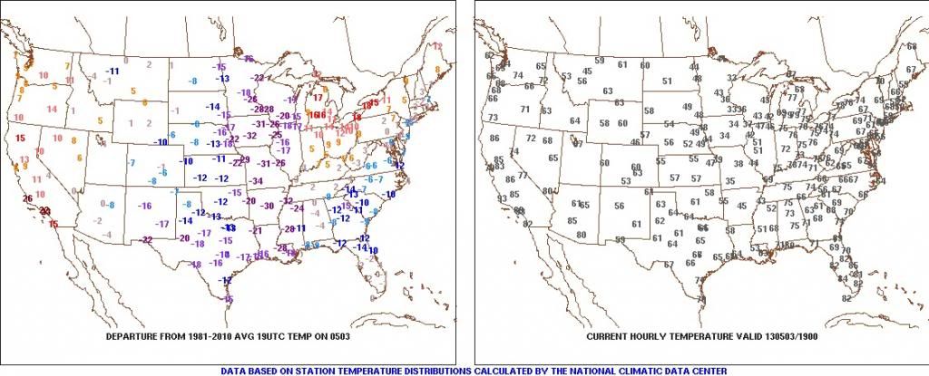
Memphis is currently sitting at 43F which is extraordinary for this late in the year. For some perspective, the record low for this date is 43F, and they've tied it at 4 PM. An average afternoon on May 3 is 78F, so it's currently 35F below normal. Tonight it's forecast to go down to 38F, which will break the daily record of 40F set in 1976, and tie the monthly record of 38F set in 1944.
Please register to post and access all features of our very popular forum. It is free and quick. Over $68,000 in prizes has already been given out to active posters on our forum. Additional giveaways are planned.
Detailed information about all U.S. cities, counties, and zip codes on our site: City-data.com.

 Please register to participate in our discussions with 2 million other members - it's free and quick! Some forums can only be seen by registered members. After you create your account, you'll be able to customize options and access all our 15,000 new posts/day with fewer ads.