Please register to participate in our discussions with 2 million other members - it's free and quick! Some forums can only be seen by registered members. After you create your account, you'll be able to customize options and access all our 15,000 new posts/day with fewer ads.
Current map... Notice the Lightning Icons.. thats Thunderstorms being reported at the climo stations and thundersnow also. Blue Outlines are SPC Heavy Snow discussions. Pink outline is Severe Thunderstorm Watch likely.
Speaking of Spring, this map is a classic Springtime temperature gradient. Specifically, yesterday's highs for the United States, which ranged from a nice and cold 20F in North Dakota to a nice and toasty 96F in South Texas.
Those same locations in Texas that were >90F are now sub-70F, and those same locations in Illinois/Indiana that were >50F yesterday are now staring down the barrel of 8-12 inches of snow . This is what March should look like (-10F monthly departures from normal not withstanding; normal in the U.S. is too hot ).
85MPH in Orlando, FL at 2:40pm. Tornado warning now cancelled but T-Storm warning to the Cape Canaveral coast.
* AT 255 PM EDT...NATIONAL WEATHER SERVICE DOPPLER RADAR INDICATED SEVERE THUNDERSTORMS CAPABLE OF PRODUCING QUARTER SIZE HAIL...AND DAMAGING WINDS IN EXCESS OF 60 MPH. THESE STORMS WERE MOVING THROUGH EAST ORANGE COUNTY TOWARD TITUSVILLE...CAPE CANAVERAL...COCOA...AND ROCKLEDGE...MOVING EAST AT 55 MPH.
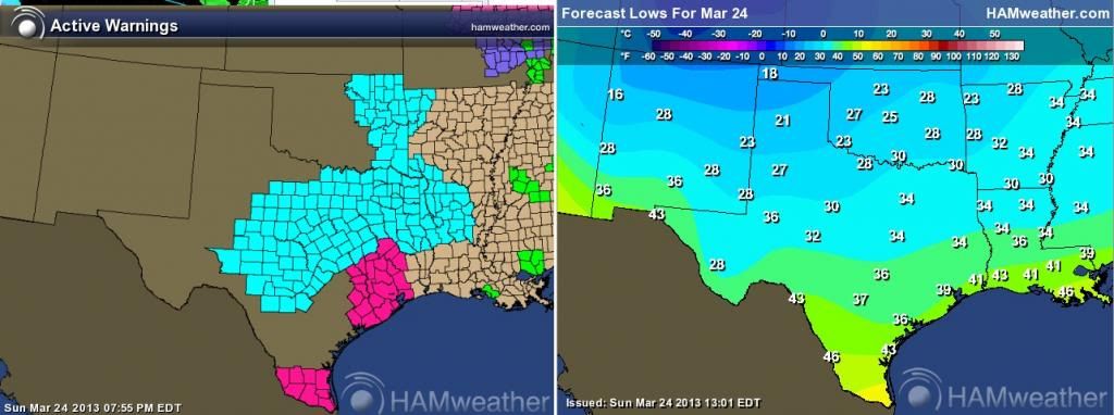
Freeze Warnings in Texas. Normal low are around 50
NATIONAL WEATHER SERVICE FORT WORTH TX
344 PM CDT SUN MAR 24 2013
...FREEZE WARNING IS IN EFFECT FOR ALL OF NORTH AND CENTRAL TEXAS
FROM 2 AM TO 9 AM CDT MONDAY...
.TEMPERATURES WILL FALL TO NEAR OR BELOW FREEZING ACROSS MOST OF
NORTH AND CENTRAL TEXAS TONIGHT. IF YOU HAVE TEMPERATURE-SENSITIVE
PLANTS...YOU WILL NEED TO BRING THEM INDOORS OR COVER THEM WITH
PROTECTIVE MATERIALS.
Where're the Canadians at? There's a lack of Canadian maps in this thread . I don't think there's a Mexican that regularly posts here so, oh well
Please register to post and access all features of our very popular forum. It is free and quick. Over $68,000 in prizes has already been given out to active posters on our forum. Additional giveaways are planned.
Detailed information about all U.S. cities, counties, and zip codes on our site: City-data.com.

 Please register to participate in our discussions with 2 million other members - it's free and quick! Some forums can only be seen by registered members. After you create your account, you'll be able to customize options and access all our 15,000 new posts/day with fewer ads.


 . This is what March should look like (-10F monthly departures from normal not withstanding; normal in the U.S. is too hot
  ).
).