Please register to participate in our discussions with 2 million other members - it's free and quick! Some forums can only be seen by registered members. After you create your account, you'll be able to customize options and access all our 15,000 new posts/day with fewer ads.
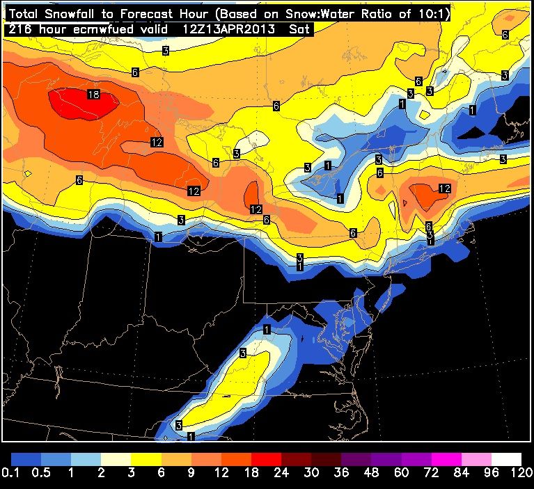
Euro00z shows a major snowstorm in the NorthEast next week.
Surface Map early Saturday morning
The result. Snow totals.
Widespread 6-18" from PA to Maine
Data output for Poughkeepsie, NY and Windsor Locks, CT. notice the 850 temps crash and precip still around.
They also said the same thing for April 4th. Nothing happened. This storm probably won't either, the chances are far too slim in my opinion for this much snow this late in the year.
I think its been showing snow somewhere in the NorthEast for a while, but I also think its the first time its showing that much and that far south. So dont put stock in it unless future runs show it as well.
Here's a look at what it showed days ago for the same time frame (April 12-13)
Notice the 12" snows are further north. Obviously it's always hard to believe in the winter so its even harder to believe for Spring. I wont believe it until I see more consistancy
Notice they mention the GFS trending to Euro but if GFS is right then 70s would be reached. Euro is cooler, GFS is a warmer solution this time. Note they mention the Euro's consistancy. Meaning it hasnt flip flopped like the GFS for this coming week.
Quote:
.LONG TERM /MONDAY NIGHT THROUGH SATURDAY/...
MODELS STILL NOT IN GOOD AGREEMENT ON MUCH BEYOND THIS POINT.
CMC CONTINUES TO SHOW A STRONGER RIDGE BUILDING... AND PUSHING THE
FRONT BACK TO THE NORTH INTO CANADA.
GFS IS SIMILAR... BUT HAS BACKED OFF A BIT ON THE ADVANCING WARM AIR PUTTING THE FRONT
SOMEWHERE ACROSS NORTHERN NEW ENGLAND FOR MUCH OF THE WEEK.
THE ECMWF HAS MAINTAINED ITS CONSISTENT SCENARIO OF KEEPING THE FRONT
SOUTH OF THE REGION... KEEPING NORTHERN NEW ENGLAND IN A COLDER
PATTERN.
GIVEN THE CONSISTENCY OF THE ECMWF... HPC (OR WPC IF YOU
PREFER) PREFERENCE FOR THE ECMWF AND THE SENSE THAT THE GFS IS
TRENDING TOWARD THE ECMWF SOLUTION... HAVE DECIDED TO GO ALMOST
COMPLETELY WITH THE ECMWF SCENARIO FOR THIS FORECAST FROM
WEDNESDAY ONWARD.
HIGH TEMPERATURES IN THE 40S AND 50S ARE EXPECTED THURSDAY AND FRIDAY. HOWEVER... STILL MUST NOTE THAT IF THE GFS SOLUTION PANS OUT TEMPERATURES WELL INTO THE 70S WOULD BE REACHED.
The sun decided to join us at the end of the day after cloudy skies for the past 3 hours or so. Ended up being 60 F, a couple of degrees below the forecast high, but that was because of the aforementioned clouds. Tomorrow the real heat will begin; 72 F! And now Tuesday will be 78!! And now Wednesday and Thursday have decided to join the 70s party as well; 76 and 71 respectively. Then finally some rain late Thursday and on Friday, and it cools down to just 50 on Saturday! Jeez, what a week this will be!
The sun decided to join us at the end of the day after cloudy skies for the past 3 hours or so. Ended up being 60 F, a couple of degrees below the forecast high, but that was because of the aforementioned clouds. Tomorrow the real heat will begin; 72 F! And now Tuesday will be 78!! And now Wednesday and Thursday have decided to join the 70s party as well; 76 and 71 respectively. Then finally some rain late Thursday and on Friday, and it cools down to just 50 on Saturday! Jeez, what a week this will be!
Was watching the temps closely all day.. I couldnt get past low 50s meanwhile saw NJ in 60s and DC in 70s. Needed wood stove today with wind felt like upper 40s.
I know that heat is making its way to me but... maybe not... its going to be interesting to see how far north it goes.
Here's what the GFS18z shows as far as temps on Wednesday and then on Saturday
Orange lines are the 500mb heights. Ridge first then out it goes and in comes the trough and colder air. That front will be sharp and produce some storms along the way.
Please register to post and access all features of our very popular forum. It is free and quick. Over $68,000 in prizes has already been given out to active posters on our forum. Additional giveaways are planned.
Detailed information about all U.S. cities, counties, and zip codes on our site: City-data.com.

 Please register to participate in our discussions with 2 million other members - it's free and quick! Some forums can only be seen by registered members. After you create your account, you'll be able to customize options and access all our 15,000 new posts/day with fewer ads.


 And now Tuesday will be 78!!

