Please register to participate in our discussions with 2 million other members - it's free and quick! Some forums can only be seen by registered members. After you create your account, you'll be able to customize options and access all our 15,000 new posts/day with fewer ads.
That ranking is skewed for a number of reasons. First and foremost, the number of stations around today that were not around 120 years ago, and second, you will never get me to believe that they adequately adjust for UHI not to mention instrument calibration errors.... This is why that satellite measurements are the most accurate imho.
I'm about full for my winter taste buds. This has been an awesome winter.... But if this below average trend goes too far into March or beyond (which I now think it will) you will begin to hear me ***** and moan about the cold as well.
And don't even go there if my summer turns out to be cooler than normal.
My one saving grace in the analogs is that even though this February is now tied for the coolest on record for Chicago with 1979, February 1936 was the second coldest on record, and we all know how that summer turned out.
Actually, George. I heard that the great lakes region has the possibility of a unusually cool cloudy summer this year, with average highs limited to just 76 F in July. So sorry about that .
Actually, George. I heard that the great lakes region has the possibility of a unusually cool cloudy summer this year, with average highs limited to just 76 F in July. So sorry about that .
Are you teasing me!
With all the lake ice this year, the colder than normal Great Lakes water will definitely have an effect on our spring (lake breezes will sting more), but as for summer, the Upper Midwest is more effected by the Lakes than we are here at the southern most end of Lake Michigan. Tom Skilling our local met guru a couple weeks back stated that there are some long range model indicators which point to a warmer than average summer here. In the end, that will depend on how much spring rains we get, and how much soil moisture there is.
Yes, looking forward to colder weather again! I much prefer the deeper arctic cold and clear skies than 32-40F with rain and grey days.
By the way, it never got to -20F or below so far this Winter in Madison. I think the airport has a minor heat island because many other regional locations have recorded lows colder than -25F so far with -33F to -35F being recorded in locations such as Sparta and Black River Falls.
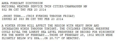
this northbound storm’s projected Friday central pressure of 972mb (which equates 28.70″ of mercury) may well equal the Badger State’s record for its lowest February barometric pressure of 972mb recorded on Feb. 28, 1902 —-112 years ago!
I wonder what the final lowest pressure was in WI from the storm. Looking at SPC loop looks like 974mb might of been the lowest pressure but a station might of recorded 972mb or lower. It's good they used "near" and "projected" in that article. It was projected to be 972 or lower. So I wonder if the 1902 record stands.
Most of the country, including the big Midwestern cities and just about everywhere in the Northeast, has experienced multiple major thaws and rainstorms in this "brutal relentless winter". I'm sorry, but rocketing up to the 40's and 50's every week or two certainly counts as a reprieve from cold and snow. Winter is a season, not an event, and I'm sick and tired of hearing whining and moaning about cold and snow that has been periodic (not relentless) in nature (via the many thaws that interrupted it), and even those periods have not even lasted for the duration of what is supposed to be the winter season. Of course these same whiners don't bat an eye when heat and warmth lasts for 5 months at a stretch. Even in Minneapolis they've experienced 40's on 5 occasions this winter, so even there I wouldn't characterize it as relentless, but I could understand someone there complaining about potent and persistent cold, because it is potent and persistent. Denizens of warmer cities have no such excuse.
Assuming the Accuweather forecast for the rest of the winter is more or less accurate, NYC will have seen 29 days with high temperatures below freezing. Even this bare minimum requirement for being wintry only happened for 32% of the winter. 39 days have reached 40F or higher, comprising 43% of the winter. So even in this "unrelenting cold" temperatures conducive to major thawing, that by any definition is mild in a winter context, have been in place for almost half of the winter - almost half of the winter was well above freezing, and this is the brutal unrelenting cold they're whining about? Give me a break. That's not to say that temperatures haven't been very cold relative to normal this year or that their snowfall hasn't been very impressive - both of those are true, but it just serves to illustrate the point I have always made about just how warm normal actually is in NYC. Of course points further north and further into the interior have experienced colder weather, but the fundamentals remain similar, and the fact is a lot of the whining has emanated from the NYC area and areas with similar climates.
With this in mind, talking about Spring almost seems silly, considering that most of the country has received multiple tastes of Spring already, albeit much less than usual. It's not time for Spring yet, and March by all right should be a slightly milder and much stormier version of midwinter when you begin the transition to Spring*. Let Easter (April 20 this year) be the time when Spring reaches peak bloom; it'll be much more enjoyable that way, and it will be a great pleasure to partake in the monster snows and ongoing cold that characterize the best Marches .
*And by that I don't mean the "every day 70-90F, no frost, bouts of high humidity" type of Spring that media personalities hanker after that is indistinguishable from Summer in both feeling and foliage - I'm talking about the "every day 45-75F, frequent light frost, the last light snow, no humidity, everything in bloom" type of Spring.
Quote:
Originally Posted by nei
Where's Patricius Maximus these days? This must be his winter dream come true.
A winter dream come true for me would be highs averaging in the singles, no thaws of any kind, and at least 150 inches of snow for the season. Very few places in the lower 48 have experienced that this winter; to be sure, a lot more places than usual, but still a tiny fraction of the country as a whole. I have noticed that many cities in the Midwest have experienced a taste of what my ideal winter would be like - if you took the coldest periods of the winter there for a normal cold spell, and combined that with the snowiest periods of the winter for a normal warm spell, it would be perfect.
Quote:
Originally Posted by chicagogeorge
Man look at this cold spell. I tell you this will be the norm at least through March if not for the entire spring.
The current pattern of the Pacific ridge, the Eastern trough, and no blocking/troughing around Greenland has lasted since late November, so about 3 months. That is usually the longest any given pattern lasts, and I find it intriguing that after a one-week interlude the same pattern is returning and will apparently stay in place for at least the next few weeks. It's not unheard of for one cold pattern to change into a different configuration that also produces cold, but almost the same setup? I've never seen that happen.
If it continues through around Easter, that will mean essentially the same pattern will have been in place for 5 months. I myself wouldn't mind if it continued for years, but it's strange .
First... Looking at the actual data from them, check out Tuesday morning.
Euro says Danbury 7°F. GFS says 20°F.
GFS pretty much has it dry for next 1.5 weeks aside from couple snow showers.
Second... Here's the EURO for Wednesday 26th. Prime spot for 5"+ snows for New England.
Prints 0.43" qpf for Danbury at 15:1 ratios that's 5-7" snow.
0.37" for BDL Maybe 20:1 ratios
0.51" for Providence, RI.
0.54" for Islip,NY.
0.44" for Boston,MA.
0.64" for Nantucket,MA
0.45" for NYC
Third... NWS Boston mentions the Euro and the ensemble members trended stronger with the Wednesday storm but there's still some spread & uncertainty.
00Z ECMWF HAS TRENDED STRONGER WITH 989 MB LOW NEAR THE 40N/70W BENCHMARK 18Z WED AND UP TO 0.50 INCH OF QPF OVER SOUTHERN NEW ENGLAND. MEANWHILE THE 00Z GFS OFFERS CYCLOGENESIS FARTHER OFFSHORE WITH AN INVERTED/NORLUN TROUGH EXTENDING NORTHWEST BACK INTO NEW ENGLAND WED. THE 00Z GEFS AND ECENS HAVE TRENDED STRONGER BUT STILL LOTS OF SPREAD AMONG ALL INDIVIDUAL ENSEMBLE MEMBERS. WILL MAINTAIN CHANCE POPS TO ADDRESS FORECAST UNCERTAINTY ESPECIALLY AT THIS TIME RANGE. HOWEVER FORECAST INTUITION/PATTERN RECOGNITION SUGGEST HEDGING TOWARD STRONGER SOLUTIONS GIVEN HIGH AMPLITUDE FLOW PATTERN AND POLAR ORIGINS OF JET ENERGY.
Forth... This is the 850mb temps Wednesday morning during the precip from Euro. No question it would be snow falling only ..
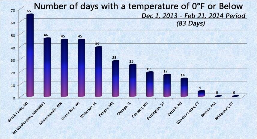
I was looking up our stats here in Grand Forks North Dakota (city location). Since Dec 1st we have had 64 todays (incl today) with a minimum temperature of below zero (F). Current forecast has below zero lows each day til the end of Feb.... so for the 90 day period of meteorological winter (Dec-Feb) we will have 70 days out of 90 with a temperature below zero.
This would be in a tie for third place all time.... 74 days was the max (Dec-Feb) in 1916-17 and 71 in 1977-78 and 70 in 1949-50.
Interestingly enough no record lows have been set for the Grand Forks city location.
For the Dec-Feb 21st period the average temp this winter is 2.06 degrees, which is in 13th place all time.
If you extend out the period to include months from November to April, the max number of days with a temp below zero was 85 in 1977-78.....
WOW! Nice stats there. Meanwhile only twice here of 0 or lower!
You've inspired me to look at others. So here's a graph I made. Impressive you have more than Mt Washington!
Still some snow on the ground here, but really only in shaded spots. This is probably the least amount of snow we've had on the ground since right before the snowstorm on January 21st. Can't say I can complain about that. More than a month of snow on the ground. I actually looked out at the woods this morning with the sun shining bright, almost no snow, and thought it looked weird.
And of course, with such a warmup, like clockwork, out come the stinkbugs. I just killed one in my room this morning. These creatures are the absolute bane of my existence, and I've come to associate their presense with warm spells in winter, spring, and fall. This just intensifies my dislike of warm weather. They are obnoxious, just like a winter thaw, or a strong spring warmup. Hopefully this winter took a big toll on them.
Please register to post and access all features of our very popular forum. It is free and quick. Over $68,000 in prizes has already been given out to active posters on our forum. Additional giveaways are planned.
Detailed information about all U.S. cities, counties, and zip codes on our site: City-data.com.

 Please register to participate in our discussions with 2 million other members - it's free and quick! Some forums can only be seen by registered members. After you create your account, you'll be able to customize options and access all our 15,000 new posts/day with fewer ads.


 .
.


 .
.