Please register to participate in our discussions with 2 million other members - it's free and quick! Some forums can only be seen by registered members. After you create your account, you'll be able to customize options and access all our 15,000 new posts/day with fewer ads.
URGENT - WINTER WEATHER MESSAGE
NATIONAL WEATHER SERVICE GREEN BAY WI
311 PM CST SUN NOV 9 2014
...EARLY SEASON WINTER STORM TAKING AIM ON WISCONSIN...
.A LARGE SWATH OF HEAVY SNOW AND MIXED PRECIPITATION...ALONG WITH GUSTY
WINDS WILL CREATE SIGNIFICANT TRAVEL PROBLEMS ACROSS PORTIONS OF
CENTRAL...MUCH OF NORTHERN AND PORTIONS OF NORTHEAST WISCONSIN
FROM MONDAY MORNING INTO TUESDAY AFTERNOON. A STRONG LOW PRESSURE SYSTEM
WILL APPROACH THE REGION ON MONDAY...THEN MOVE ACROSS THE STATE MONDAY
NIGHT AND TUESDAY AFTERNOON.
STAY TUNED FOR LATER FORECAST UPDATES AS THERE IS STILL SOME
UNCERTAINTY WITH RESPECT TO THE TRACK OF THIS WINTER STORM.
WIZ005-010-011-018-019-030-100515-
/O.CON.KGRB.WS.W.0006.141110T1200Z-141112T0000Z/
VILAS-ONEIDA-FOREST-LINCOLN-LANGLADE-MARATHON-
INCLUDING THE CITIES OF...EAGLE RIVER...RHINELANDER...CRANDON...
TOMAHAWK...ANTIGO...WAUSAU
311 PM CST SUN NOV 9 2014
...WINTER STORM WARNING REMAINS IN EFFECT FROM 6 AM MONDAY TO
6 PM CST TUESDAY...
* SNOW WILL BEGIN MONDAY MORNING AND CONTINUE INTO TUESDAY AFTERNOON. THE
SNOW WILL BE HEAVY AT TIMES FROM MONDAY AFTERNOON INTO TUESDAY
AFTERNOON.
* SNOWFALL ACCUMULATIONS OF 8 TO 16 INCHES ARE LIKELY ACROSS
NORTH-CENTRAL WISCONSIN WITH THE HIGHEST AMOUNTS CLOSER TO THE
UPPER MICHIGAN BORDER. THE SNOW COULD BE MIXED WITH SLEET OR
PERHAPS RAIN FOR A BRIEF PERIOD ESPECIALLY LATE MONDAY AFTERNOON
INTO EARLY MONDAY EVENING ESPECIALLY SOUTH OF HIGHWAY 29.
* TRAVEL WILL BE IMPACTED BY THE HEAVY SNOW AND SOME MIXED
PRECIPITATION. STRONG WINDS WILL CREATE BLOWING AND SOME
DRIFTING OF THE NEW SNOW.
This can't be right Euro's 10 day snow on the ground forecast is insane! This would be impressive in January let alone mid November
Yeah, I'm ignoring that. AccuPro doesn't factor in melting so while the Euro does show show falling in all those locations I have a hard time believing the sticking part for all these locations. That would be SICK.
I'm about to post the Euro sounding for 2 places... Give me a few as it loads.
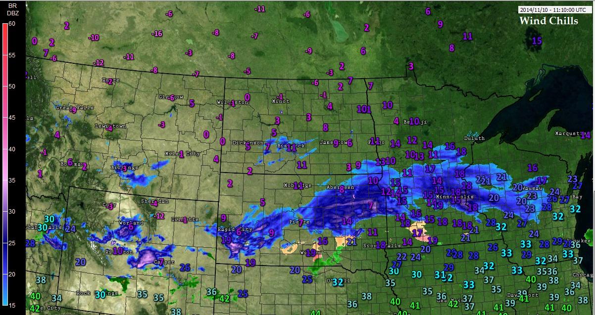
St Paul, MN right now outside where the heavy stuff is falling
Check it out... Just love checking out and learning about this stuff.
Latest Euro00z Soundings for Memphis, TN Sunday 1am & for NYC Monday 1pm.
Temperatures riding the freezing line at about 5000 feet.. but it's below freezing above that level with moisture and below freezing below that level as well.
Except the very surface in NYC showing 1.1C but the layer riding the freezing line is shallow, so this is snow & sleet falling to the surface at these hours based on this Euro run
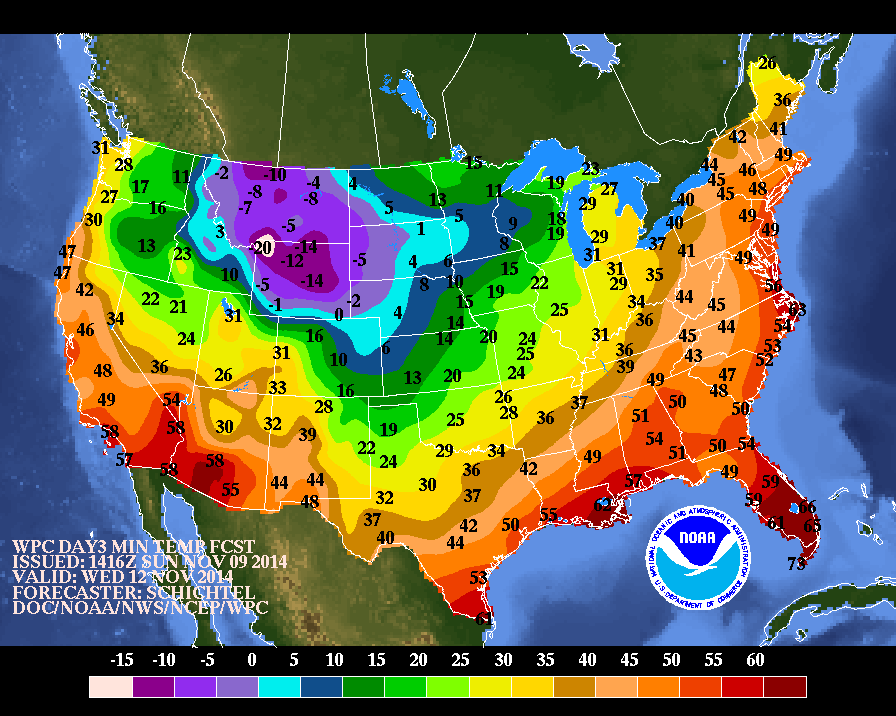
I'm jealous of anyone who lives east of the Rocky Mountains! California isn't going to see much of this cold air, and especially not Southern California. The real irony? I'm going to visit my dad and stepmom in Florida this weekend, and it should be nice there as well - probably in the mid-80s! I have to go through Dallas to get there; I'm just crossing my fingers that I won't need to leave the airport for any reason, because I'm only taking a sweater and a very thin windbreaker!
All of the charts and analysis are fascinating! I love weather (and yes, I'm living in the wrong part of the country!).
Please register to post and access all features of our very popular forum. It is free and quick. Over $68,000 in prizes has already been given out to active posters on our forum. Additional giveaways are planned.
Detailed information about all U.S. cities, counties, and zip codes on our site: City-data.com.

 Please register to participate in our discussions with 2 million other members - it's free and quick! Some forums can only be seen by registered members. After you create your account, you'll be able to customize options and access all our 15,000 new posts/day with fewer ads.


 Euro's 10 day snow on the ground forecast is insane! This would be impressive in January let alone mid November


 California isn't going to see much of this cold air, and especially not Southern California.
  The real irony? I'm going to visit my dad and stepmom in Florida this weekend, and it should be nice there as well - probably in the mid-80s! I have to go through Dallas to get there; I'm just crossing my fingers that I won't need to leave the airport for any reason, because I'm only taking a sweater and a very thin windbreaker!


