Please register to participate in our discussions with 2 million other members - it's free and quick! Some forums can only be seen by registered members. After you create your account, you'll be able to customize options and access all our 15,000 new posts/day with fewer ads.
It's already Thursday here, so when will Thursday start in California?
5.5 hours from now. New drought maps will be released 8:30 eastern time tomorrow (5:30 am in California)
The data cutoff for Drought Monitor maps is Tuesday at 7 a.m. EST. The maps, which are based on analysis of the data, are released each Thursday at 8:30 a.m. Eastern Time.
Full fledge blizzard for the higher up.. 2-3 feet in spots. Hurricane force gusts possible. Theres going to be some awesome back drop views from down below!
...BLIZZARD WARNING REMAINS IN EFFECT FROM 7 AM THURSDAY TO 4 AM
PST FRIDAY ABOVE 6500 FEET...
* IMPACTS:EXTREMELY HAZARDOUS WHITEOUT CONDITIONS. PASSES MAY
CLOSE FOR SEVERAL HOURS.
* SNOW ACCUMULATIONS: 6 TO 13 INCHES WITH 2 FEET OR MORE ALONG THE
CREST.
* TIMING: SNOW WILL BEGIN LATE TONIGHT INTO THURSDAY MORNING AND
CONTINUE LESS HEAVY INTO FRIDAY AFTERNOON. THE PERIOD OF
HEAVIEST SNOW IS EXPECTED THURSDAY AFTERNOON AND THURSDAY NIGHT.
THE STRONGEST WINDS ARE EXPECTED TONIGHT AND THURSDAY.
VISIBLILITES WILL DROP TO NEAR ZERO AT TIMES...ESPECIALLY DURING
THE AFTERNOON.
* SNOW LEVELS: SNOW LEVELS WILL INITIALLY BE ABOVE 6500 FEET
LATE TONIGHT INTO THURSDAY...LOWERING TO 4500 TO 5500 FEET
THURSDAY NIGHT INTO FRIDAY.
* WIND: SOUTHERLY WINDS 25 TO 50 MPH WITH GUSTS TO 80 MPH OR
HIGHER WILL DEVELOP TONIGHT INTO THURSDAY. WINDS DECREASE BY
FRIDAY MORNING.
Looks like we will likely get a good soaking out of this but not likely to get any thunder or lightning here in Orange County.
The Bay Area will be effected far more. My sister's kids' schools are closed tomorrow because of the storm and they live about 30 miles southeast of San Francisco. Before this, I have never heard of schools closed in California due to weather outside of the high elevations that get effected by snow.
"Locally heavy precipitation fell across portions of the state this past week. Amounts ranged from 1-6 inches (liquid equivalent) across a large portion of northern California, and parts of the central and southern coastal areas. Up to 3 inches of precipitation (liquid equivalent) was reported in the southern Sierras. However, snow pack remains well below-normal in many areas due to the relatively mild temperatures associated with these storm systems. In addition, much more precipitation is needed to replenish lost reservoir storage. There are still deficits in the conservation pool of millions of acre-feet in the Shasta and Oroville reservoirs north of Sacramento. Oroville reservoir gained about 100,000 acre-feet of storage in the recent storm, returning to one million acre-feet in storage capacity. The capacity of this reservoir is 3.5 million acre-feet, with a flood reserve space of 750,000 acre-feet. Well to the south, last week’s storm produced several inches of rain for San Luis Obispo, Santa Barbara, Ventura, and Los Angeles Counties. However, this was not enough to generate runoff in natural streams and therefore did not provide any benefit to surface reservoirs. Since the start of the Water Year (October 1), almost all precipitation gauges in the area are still running below normal. No revisions were made to the California drought depiction this week. With the anticipation of another significant precipitation event in the short-term, alterations could be required next week, pending resulting impacts."
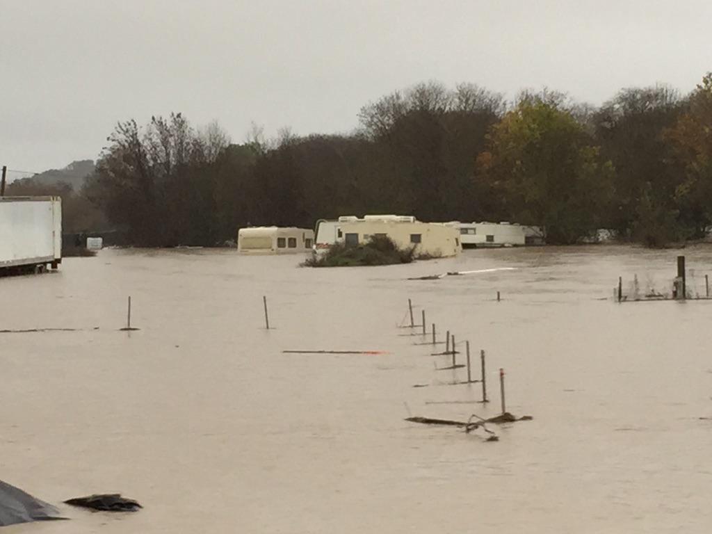
Why did they say "this was not enough to generate runoff in natural streams?" We all saw that video of the LA river rising from this storm.
El Camino in San Bruno . Is this person trying to drive across?
Unfortunately the drains in that area "drain to the Bay". Rain gets captured when it rains up in the "Gold Country" in the foothills outside of Sacramento. Fortunately that area is getting 10" of rain, places like Folsom Lake will capture that. The Bay Area is so close to the sea/ocean that rain just serves to green things up. You want the rain in the Central Valley and the foothills (and snow in higher elevations) of the Sierra to replenish the water supply. The fact that the waterfalls in Yosemite are flowing bodes well. That's where you want the water.
Unfortunately the drains in that area "drain to the Bay". Rain gets captured when it rains up in the "Gold Country" in the foothills outside of Sacramento. Fortunately that area is getting 10" of rain, places like Folsom Lake will capture that. The Bay Area is so close to the sea/ocean that rain just serves to green things up. You want the rain in the Central Valley and the foothills (and snow in higher elevations) of the Sierra to replenish the water supply. The fact that the waterfalls in Yosemite are flowing bodes well. That's where you want the water.
Good info. Thanks.
-------
Current Radar, Temps and MSLP. 106mph wind gust! 80mph in Oregon. Lots of wind reports Hurricane strength and flooding in spots. I'm seeing 4-5" rain total reports.
Please register to post and access all features of our very popular forum. It is free and quick. Over $68,000 in prizes has already been given out to active posters on our forum. Additional giveaways are planned.
Detailed information about all U.S. cities, counties, and zip codes on our site: City-data.com.

 Please register to participate in our discussions with 2 million other members - it's free and quick! Some forums can only be seen by registered members. After you create your account, you'll be able to customize options and access all our 15,000 new posts/day with fewer ads.


 but not likely to get any thunder or lightning
  here in Orange County.


 80mph in Oregon. Lots of wind reports Hurricane strength and flooding in spots. I'm seeing 4-5" rain total reports.