Please register to participate in our discussions with 2 million other members - it's free and quick! Some forums can only be seen by registered members. After you create your account, you'll be able to customize options and access all our 15,000 new posts/day with fewer ads.
I never thought 80F lows would be rare in a place like Louisiana. NYC's warmest ever low was 86F, on 3 different occasions, most recently in 2013. I believe it maxed out at 84F earlier in the month.
They're not nearly as common as they are in the cities and inner suburbs, but some of NYC's outer suburbs and rural areas saw lows at/around 80F with the major heat/humidity event earlier this month.
I too am surprised as even Toronto has had a 27C low.
I guess can not under estimate the power of a strong UHI.
I never thought 80F lows would be rare in a place like Louisiana. NYC's warmest ever low was 86F, on 3 different occasions, most recently in 2013. I believe it maxed out at 84F earlier in the month.
They're not nearly as common as they are in the cities and inner suburbs, but some of NYC's outer suburbs and rural areas saw lows at/around 80F with the major heat/humidity event earlier this month.
Maybe it's also the close proximity to the ocean that makes them more likely around NYC. Parts of Louisiana closer to the coast had lows at 80F or above this summer.
It's 423 miles from me and 9 miles from the center of Paris. I used to live between Orly airport and central Paris and used that station as a reference. It's also a good location to compare to other cities, as most weather stations are from airports.
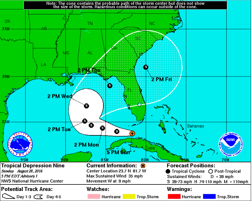
Latest from NWS on the tropical disturbance south of Florida:
Quote:
TROPICAL DEPRESSION NINE DISCUSSION NUMBER 1
NWS NATIONAL HURRICANE CENTER MIAMI FL AL092016
500 PM EDT SUN AUG 28 2016
Data from a NOAA Hurricane Hunter aircraft indicate that the area of
low pressure located in the Florida Straits now has a well-defined
center. Satellite imagery shows a significant increase in the
convective organization today, and as a result the system is now
classified as a tropical cyclone. The initial intensity is set to
30 kt based on the highest believable wind data from the aircraft,
which reported a central pressure of 1009 mb.
The depression will be moving through a marginal environment for
intensification during the next day or so, with vertical shear of
15 to 20 kt. As a result only slow strengthening is expected in
the short term. Later on, the environment may improve a little as
the shear is forecast to decrease somewhat and become
southwesterly, which should allow for a little more strengthening.
However, there are mixed signals in the model guidance, with the
ECMWF now showing the cyclone dissipating in the Gulf, while the
GFS delays development until 4-5 days. Much of the tropical
cyclone guidance is more aggressive. Given this uncertainty, the
NHC intensity forecast is quite conservative and shows the system
peaking at 45 kt, below all the explicit intensity guidance in
consideration of the negative signal from the ECMWF. Needless to
say, the confidence in the intensity forecast is even lower than
usual for this system.
The initial motion estimate is an uncertain 270/09 given the recent
formation of the center. The cyclone will be steered in the short
range by a mid-level ridge centered over the southeastern United
States. This ridge will weaken in 2-3 days, which will cause the
cyclone to slow down and turn northward during this time. Late in
the period a northeastward acceleration is expected ahead of an
approaching mid-latitude trough. There is reasonable agreement in
the track of the cyclone in the global model guidance, although
there is a fair bit of along-track spread late in the period. The
NHC forecast is close to a consensus of the GFS and ECMWF through
day 4 and is a little faster than the GFS and GEFS ensemble mean at
day 5.
Maybe it's also the close proximity to the ocean that makes them more likely around NYC. Parts of Louisiana closer to the coast had lows at 80F or above this summer.
Nope mostly their massive UHI. 80 degree lows on the coast don't become a common summer occurrence till further south on the coast in Virginia. Their location on the coast certainly helps though.
The incomparably huge UHI coupled with the long 15 hour days allow those lows in NYC. That's a long time during which concrete absorbs the heat from the sun, but there's not enough time at night to re-radiate it back into the atmosphere. High humidity also helps but to a lesser extent.
Been below average here. 92 max today and yesterday, and 93 the day before. Sunny humid garbage. Could be worse tho.
Different story in Oymyakon. They had their 4th coldest August low ever! Would pay to be there. - :
Please register to post and access all features of our very popular forum. It is free and quick. Over $68,000 in prizes has already been given out to active posters on our forum. Additional giveaways are planned.
Detailed information about all U.S. cities, counties, and zip codes on our site: City-data.com.

 Please register to participate in our discussions with 2 million other members - it's free and quick! Some forums can only be seen by registered members. After you create your account, you'll be able to customize options and access all our 15,000 new posts/day with fewer ads.