Please register to participate in our discussions with 2 million other members - it's free and quick! Some forums can only be seen by registered members. After you create your account, you'll be able to customize options and access all our 15,000 new posts/day with fewer ads.
Interesting how they shade pretty much the entire US on that tornado map. Once again, careless blobs being drawn to represent "tornado prone" areas.
I think it just shows how extreme the eastern US is, yes a place such as washington is basicly tornado less when compared to eastern US, however when compared to the rest of the world, which many places literally will never even have a tornado form, well then WA does seem a bit tornado-y. that map was just showing where tornadoes have formed generally, without differentiating between low, medium, and high probability.
WA doesn't get those big strong tornadoes like back east, but we do get small weak ones from time to time. Washington Tornadoes
It's a sloppy map, it just shades random chunks of areas on various continents, then calls them tornado prone.
Alabama is certainly square in the bullseye. Add to the mentioned before fact that we have low visibility to the horizon in many locations, and it's particularly dangerous. Some springs, it feels like living in a war zone. After the April of 2011 outbreak, I knew it was bad. I had watched the coverage and knew there were people hurting.
But I had a business trip south to Montgomery planned for the day after. On that trip south on Interstate 65, the true magnitude of the emergency came to light. On that bright sunny day, the lines of military vehicles heading north from Maxwell AFB and points south were unending. I've never seen such a mobilization on US turf. It looked like and invasion. I'm certain some folks from New Orleans and perhaps Oklahoma City can related. Tears filled my eyes.
My college hometown, Tuscaloosa, was particularly hit hard. Link to Al.Com's coverage of the 5th anniversary and the hard work of many to bring the city back on line.
Location: Segovia, central Spain, 1230 m asl, Csb Mediterranean with strong continental influence, 40º43 N
3,094 posts, read 3,575,147 times
Reputation: 1036
Quote:
Originally Posted by nei
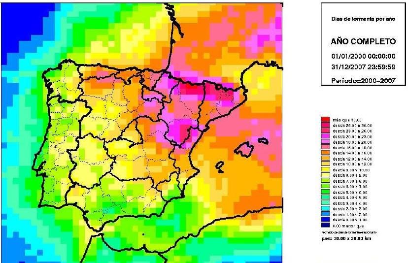
Does it match well with thunderstorm frequency?
No, it doesn't. Coastal Andalusia sometimes experience weak tornadoes that aren't from deep convection within summer months, so such rare tornadoes happen when some strong cold fronts pass through during winter.
Anyway, this is the thunderstorm frequency map, and most of them happen from early May to late September, except in the far south. Highlithed red colour means 30 days with thunderstorm per year (or even a few more), whereas dark blue one means less than 1:
It looks like my area may have been more prone to violent tornadoes in the early 20th century for some reason. The area was struck by several deadly tornadoes around that time. Tornadoes struck Alexandria in both April 1907 and April 1923. There was also a long track EF-4 tornado on April 24, 1908 that first touched down about 12 miles south of Alexandria, went north of Natchez and traveled into Mississippi. The total track was 105 miles long and killed a total of 91 people and injured 400 (this number was likely higher since black people were usually not included at the time). This tornado was part of the 1908 Dixie outbreak. https://en.wikipedia.org/wiki/1908_D...rnado_outbreak
The late 20th century and 21st century so far have been pretty quiet around here but there have been weak tornadoes.
Please register to post and access all features of our very popular forum. It is free and quick. Over $68,000 in prizes has already been given out to active posters on our forum. Additional giveaways are planned.
Detailed information about all U.S. cities, counties, and zip codes on our site: City-data.com.

 Please register to participate in our discussions with 2 million other members - it's free and quick! Some forums can only be seen by registered members. After you create your account, you'll be able to customize options and access all our 15,000 new posts/day with fewer ads.