Please register to participate in our discussions with 2 million other members - it's free and quick! Some forums can only be seen by registered members. After you create your account, you'll be able to customize options and access all our 15,000 new posts/day with fewer ads.
The weather always seems to come up as a subject of concerned interest for new movers, especially hurricanes/tornadoes and ice storm. Being from a coastal area where storm-water can also be a threat, I would ask what kind of issues with flooding can occur here. Obviously you are in the mountains, so it should not be a widespread problem. But how about the unlikely event of a very high tide if the side of a La Palma volcanic mountain slides into the eastern Atlantic? Is the area here elevated enough to remain above the impact of a 300' rise in sea level? What waterways leading out from the area could be pushed up in a major surge that reaches the foothills?
"But how about the unlikely event of a very high tide if the side of a La Palma volcanic mountain slides into the eastern Atlantic? Is the area here elevated enough to remain above the impact of a 300' rise in sea level?"
Hmm. Sounds like a scenario from that movie Deep Impact. Wasn't there a scene where Elijah Wood was dragging his girlfriend/wife up the side of a mountain in North Carolina to avoid the water surge created by a part of the asteroid that broke off from the comet headed toward Earth?
Not to hijack your thread, but I'm also interested in flooding events in the Asheville area and Western North Carolina, but my concerns are more mundane. As in, if you live near a creek or river, how far up or back from this body of water should you be situated? (Generally speaking). Living-wise, what sort of situations should you avoid? (For example, I would imagine homes at or near the bottom of a hill or mountain would be susceptible to seepage or water intrusion).
And generally, which areas in and around Asheville tend to be prone to flooding? Best advice for living with the waters of the Western North Carolina area?
without reading the link, my Dad used to talk about the big flood of 1910 or 20 something and he remembers cows dead in trees that had been washed away and left by the floodwaters in trees. But floods of that magnitude are rare which is why they talk of the flood of ____.
more likely is the danger of building on the side or top of a mountain or hill and having the land slide and you and your home sliiiiiide on down the hill with it. Mountains frequently lose their integrity with slow drenching storms like hurricanes that stall. and of course development that erodes the soil base and root structure holding the ground onto the mountain with deep roots.
BTW it doesn't have to be your house that is in a bad place or your ground poorly prepared. It can be your neighbor up the hill that slides down and collides.
Most of the natives would not build on top or side of a mountain or by a creek; but would build somewhere in a cove nestled at the foot of a mountain for protection.
Last edited by theoldnorthstate; 12-09-2012 at 08:55 AM..
I don't think I understand the OP's question in regards to flooding, vis a vis the La Palma situ...
If the OP was trying to make an analogy, it is really a reach: the La Palma situ, is on a volcanically formed island in the Atlantic ocean, and fairly 'recent' in geological time. The mtns of western NC are very, very old and not volcanic in any recent epoch.
A '300 ft sea level rise' would still leave much of western NC above 'sea level', though none of us reading will be around when/if that development occurs, and not sure I would want to be, either. It would make The Road look like a walk in th park...
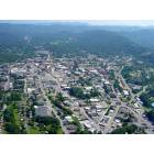
Having lived in/above Waynesville for 11 years, I got to 'experience' Hurricanes Ivan & Francis in 2004: much of downtown Canton, Clyde, Sylva, Dillsboro and parts of Waynesville were flooded, with some sections of those areas completely inundated. But, recovery was mostly complete.
We have terrific storms on our mtn ridge regularly, and water run off and collection is a concern. But, we sited our mtn joint pretty carefully and it hasn't washed away in the decade plus.
Rivulets become creeks, creeks become streams, streams become raging rivers, etc...pretty standard fare anywhere in the US, imo. I prefer higher vs lower...
GL, mD
The majority of biltmore vllage was under water too. Anywhere flat and close to a water source could have a potential for flooding. I think noaa has flood plain maps available. (or some gov source, the insurance companies make darn sure they know where it is )
The La Paloma situation is a current concern. The gap at the top of the volcano is widening, you can walk in it in some places. If it breaks off, the resulting tsunami will hit the USA's East Coast. Most of it will be under hundreds if feet of water.
Not to get into 'a meteorite might hit the planet' debate, but some reading suggests that a massive flank failure of an island based stratovolcano hasn't been recorded in written history...
GOOG'ng the situ, turns up pages of 'what if' and monster tsunami potentiality sites. And, several good scientific based predictions that suggest one need not run to the Clingman's Dome and camp out, while 'waiting'.
I took the OP's La Paloma ref to be more to do with 'flooding' situs in the mtns, whether La Paloma collapses or not, and a resulting monster tsunami as an effect of that.
QC,
If it is, we only have 3 days left to have fun, do what we want to do, etc.
Please register to post and access all features of our very popular forum. It is free and quick. Over $68,000 in prizes has already been given out to active posters on our forum. Additional giveaways are planned.
Detailed information about all U.S. cities, counties, and zip codes on our site: City-data.com.

 Please register to participate in our discussions with 2 million other members - it's free and quick! Some forums can only be seen by registered members. After you create your account, you'll be able to customize options and access all our 15,000 new posts/day with fewer ads.


 )
)