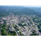
Western North CarolinaThe Mountain Region including Asheville
Please register to participate in our discussions with 2 million other members - it's free and quick! Some forums can only be seen by registered members. After you create your account, you'll be able to customize options and access all our 15,000 new posts/day with fewer ads.
I've read many posts that have had negative remarks about the Asheville traffic. I was there two weeks ago for an interview and was walking around town in the morning from around 8-9:30 and was amazed at the LOW traffic flow. Does traffic just pick up during tourist season or did I visit on an odd day?
It's not really the downtown area that is considered to have bad traffic. No parking, yes, but the traffic does increase significantly from spring on through the fall (which is about the worst time) as people try to visit downtown.
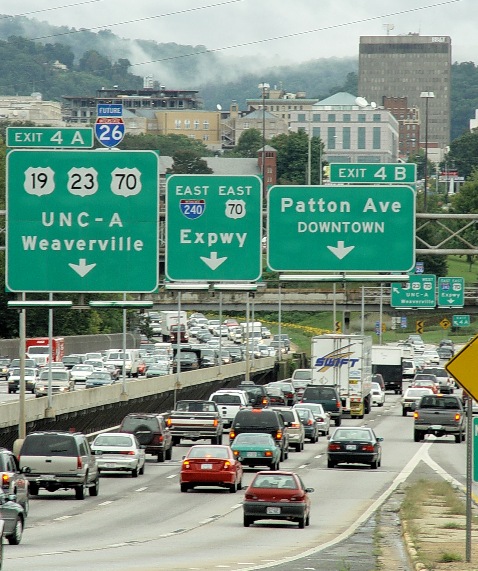
The real problems and complaints come from the major highways that are out-dated and near capacity, if not exceeding it. With the completion of I-26 through Sam's Gap in Madison County into Tennessee, the routing for I-26 through Asheville follows I-240. Most of this section does not meet today's Federal Interstate standards. The Smoky Park Bridge that crosses the French Broad River carries I-240, I-26, Patton Ave., and U.S. 19-23. Highway traffic mixes with local traffic for this crossing. There have been no major improvements to these sections of highways since they were first built.
Here are some figures for the 2005 Annual Average Daily Traffic (AADT) on the Interstates around Asheville. The charts compare the 2000 AADT to the 2005 AADT.
I-40 west of Asheville
I-40 east of Asheville
I-240 (Note the count for traffic across Smoky Park Bridge [103,000] is comparable to I-85 at the Charlotte/Douglas International Airport.)
I-26 north of Asheville
I-26 southeast of Asheville
Plans and some construction are in the works though. West of the "malfunction junction" of I-26/I-40/I-240, NCDOT is widening I-40 to eight lanes to Smoky Park Hwy. (U.S. 19-23). This is the blue section of I-40 on the above figures. Instead of having I-240 west merge on the right of I-40 west and I-26 west merge on the left of I-40 west at nearly the same point, they're adding auxiliary lanes for the on-ramps so that the traffic does not merge at one spot and continues as four lanes in one direction for close to two miles before reducing back to two lanes. This should reduce the back-ups that are common on I-26 west and I-240 west as they merge onto I-40. This project (I-4401) is scheduled for completion in May 2008.
I-4401 Public Hearing Map
Auxiliary Lanes for I-4401
The I-26 Connector (I-2513) is the planned widening of I-240 west of Asheville to eight lanes (Section A) with a new crossing of the French Broad River (Section B) and improvements to the I-26/I-40/I-240 interchange (Section C). Based on the NCDOT 2007-2013 State Transportation Improvement Program (STIP or TIP), funding is available with right-of-way purchase beginning in 2009. How the schedule and funding goes it to be seen. This is an absolutely HUGE project, coming in at $331,885,000 for improvements to 3.5 miles of highway.
Part of a public hearing map for Section A between Brevard and Amboy Roads.
Part of a public hearing map for Section B, Alternative B2 west of the Smoky Park Bridge at the Patton Ave. I-240 west split.
New crossing of the French Broad River
All of the public hearing maps for the I-26 connector are available in Adobe PDF format from this NCDOT website:
Picture I found of the Smoky Park Bridges (I-240, "Future" I-26, Patton Ave., etc.) over the French Broad River.
This photo shows one of the big choke points, imagine you are on Hwy 26, you enter from the far right lane and then have to get to the far left lane in a short distance to merge back onto the new I26 extension. Once across the bridge you are golden, but to cross that bridge thru local traffic when basically trying to stay on the highway is ridiculous. This is one of the reasons that property is a tad more expensive in North Asheville than south.
I remember when there wasn't I-240 cutting across Asheville, there was pretty much just tunnel road, it was amazing and tragic to watch a whole mountain removed to cut a new highway in. Without that cut down town traffic would be much worse than it is now.
What Tony did not mention though is that, in order to take the "tunnel" cut, you have to go through downtown to get to it. You don't get to the tunnel cut from anywhere near this mess.
If you need to get to Asheville to work, from the south or north, you need to keep a case of Rolaids in your car at all times and keep your collision insurance updated. Especially on the way home ... it's wall to wall traffic. Every day morning and night there is an accident on I-26, sometimes fatals, it's 2 lanes each way and is a major truck route. Add the tourists, motor homes, and mountain gawkers, to the mix of commuters and.... it's baaad.
As Cowboy Will said, there are plans to re-work the interchanges ... can just imagine what the detours and traffic will be like then; and at least for two years.
Traffic complaints are almost completely about interstate travel. The local roads are rarely bad.
While the widening of I-40 west of interstate 240 is occurring now, there has been debate and discussion going on for over ten years as to how to best handle the widening/rerouting of I-26/I-240. The DOT wants to widen the whole route to eight lanes, but many locals see that as overkill, and believe it will forever change the look and feel of that part of town.
As Cowboy Will said, there are plans to re-work the interchanges ... can just imagine what the detours and traffic will be like then; and at least for two years.
Two years? That's VERY optimistic. The construction project report for the current widening of I-40 west of the junction shows it began May 30, 2005 and is scheduled for completion July 9, 2008. The original date was May 30, 2008. So over three years to widen less than two miles of relatively flat and straight Interstate with only two bridges to eight lanes.
I don't even want to imagine how long the I-26 connector will take.
I work downtown and live in South Asheville, and Hendersonville Road (turns into Biltmore Ave. near Biltmore) is the best commute into work for me. Traffic can be heavy, and you have to watch for the trains in Biltmore. McDowell is a great alternate (a must if the train is coming through). I sometimes take the Blue Ridge Parkway to 240, which usually isn't bad either. I'd say the worst traffic by far is the Smoky Park Bridge.
Right on Cowboy Will. 3 years is just an "estimate". I don't even want to think about the problems that will entail with people using the shortut streets and all that, and trying to get to I-26 - 19/23 to get out of Dodge.
Please register to post and access all features of our very popular forum. It is free and quick. Over $68,000 in prizes has already been given out to active posters on our forum. Additional giveaways are planned.
Detailed information about all U.S. cities, counties, and zip codes on our site: City-data.com.

 Please register to participate in our discussions with 2 million other members - it's free and quick! Some forums can only be seen by registered members. After you create your account, you'll be able to customize options and access all our 15,000 new posts/day with fewer ads.