Please register to participate in our discussions with 2 million other members - it's free and quick! Some forums can only be seen by registered members. After you create your account, you'll be able to customize options and access all our 15,000 new posts/day with fewer ads.
Well obviously it will be either China, Russia, USA or Canada. Percentage would be a much better comparison.
I bet it's Russia because they are the largest country by far, more than double
the size of Canada, USA, or China. A lot of Siberia is mountainous over 1000m
Surprised Mongolia has not been mentioned yet, it's a relatively large country, mostly well above 1000m
I agree with China having the highest proportion of land over 1000m. From the map, it looks like that a quarter of China's elevation is above 3000m, especially when you factor in Tibet.
Lesotho in southern Africa is the only independent state in the world that sits entirely above 1000 meters in elevation. Its lowest point of 1,400 metres (4,593 ft) is the highest in the world. Over 80% of the country lies above 1,800 metres (5,906 ft).
The entire country is within the Drakensberg mountain range.
The country has 69 mountain ranges, 46,000 glaciers and is aka the Third Pole.
Thanks Smool... Your map illustrates this better than the other maps I was looking at. It does seem like the answer is China, with USA in second, and Mongolia or Canada in third.
Thanks to those that helped and had on-topic answers. Especially thanks to those that READ the question!
No, you can cleary see the Yellow river North, just outside the Green part of the map.
? Yes, you can. You can also clearly see that it's outside the green area that's solely the Yangtze River basin outlined in the map (without the Yellow River) while the borders of China and outside the green area also include Taiwan, Tibet, and Uyghurstan/Xinjiang. What is your point in using the map? It doesn't seem to fall very well into any of what you're saying.
And also, why not address the rest of the points made. Why is the mid 17th century the better demarcation point for borders? You have to understand that most arguments for and against the boundaries of China including these three territories can have similar arguments on either side of the fence for many other countries in the world, but because those countries might not be the largest countries of the world or have the bogeyman reputation that China as a developing country has, would be far less likely to be argued with such vigor or vehemence.
Anyhow, under what's generally recognized as current political borders, the answer is without a doubt China. Maybe there's a side argument for one of the Antarctic claimants as I believe Antarctica has the highest average elevation of all the continents, but territorial clams on it are controversial.
? Yes, you can. You can also clearly see that it's outside the green area that's solely the Yangtze River basin outlined in the map (without the Yellow River) while the borders of China and outside the green area also include Taiwan, Tibet, and Uyghurstan/Xinjiang. What is your point in using the map? It doesn't seem to fall very well into any of what you're saying.
Why do you keep feeding the troll? There's no point of arguing with selective history.
? Yes, you can. You can also clearly see that it's outside the green area that's solely the Yangtze River basin outlined in the map (without the Yellow River) while the borders of China and outside the green area also include Taiwan, Tibet, and Uyghurstan/Xinjiang. What is your point in using the map? It doesn't seem to fall very well into any of what you're saying.
And also, why not address the rest of the points made. Why is the mid 17th century the better demarcation point for borders? You have to understand that most arguments for and against the boundaries of China including these three territories can have similar arguments on either side of the fence for many other countries in the world, but because those countries might not be the largest countries of the world or have the bogeyman reputation that China as a developing country has, would be far less likely to be argued with such vigor or vehemence.
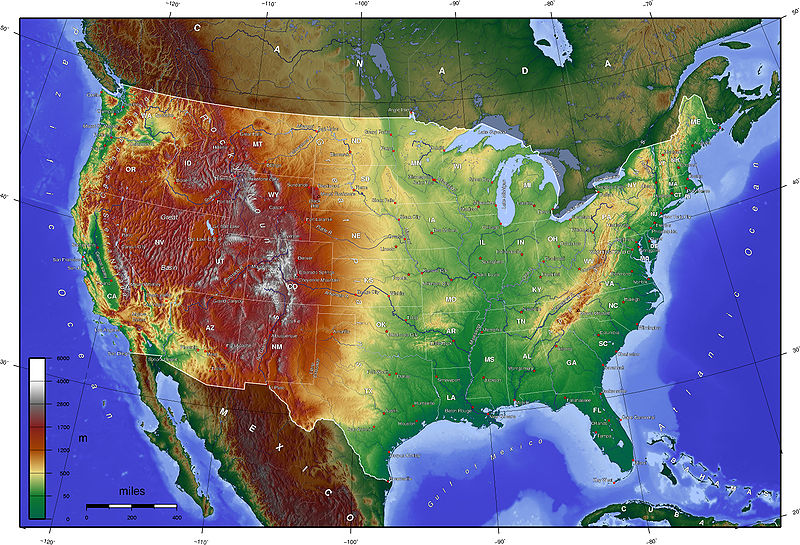
via wikipedia, everything in the red is above 1000 m
Many western states average above 1000 m, great plains and west coast states average just under 1000 m. Average elevation of course doesn't always mean more mountainous. Kansas averages higher than Alaska and Washington...
Please register to post and access all features of our very popular forum. It is free and quick. Over $68,000 in prizes has already been given out to active posters on our forum. Additional giveaways are planned.
Detailed information about all U.S. cities, counties, and zip codes on our site: City-data.com.

 Please register to participate in our discussions with 2 million other members - it's free and quick! Some forums can only be seen by registered members. After you create your account, you'll be able to customize options and access all our 15,000 new posts/day with fewer ads.