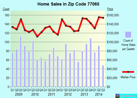
Property valuation of Maxim Drive, Houston, TX: 12915, 12918, 12919, 12922, 12923, 12926, 12927, 12930, 12931, 12934 (tax assessments)
Other nearby streets: Dermott Drive (1)  Dermott Drive (2)
Maxim Drive (1)
Maxim Drive (2)
Maxim Drive (3)
Dermott Drive (2)
Maxim Drive (1)
Maxim Drive (2)
Maxim Drive (3)
Dermott Drive (2)
Maxim Drive (1)
Maxim Drive (2)
Maxim Drive (3)
Listed properties vs overall distribution of properties in Houston, TX:
Advertisements
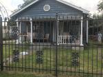
12915 Maxim Drive
Houston, TX 77065
Find on map >>
Owner: DENNIS W MATTIZA
Land value: $29,850
Building value: $81,300
Extra features value: $5,666
Total value for property: $116,816
Assessments for tax year: 2015
Prior land value: $22,388
Prior building value: $82,456
Prior extra features value: $5,666
Prior total value for property: $110,510
Building area: 1,442 square feet
Land size: 10,150 square feet
State classification: Real, Residential, Single-Family
Neighborhood: Tower
Year property was built: 1976
Condition / Desirability / Utility: Average
Exterior wall: Brick / Veneer
Foundation type: Slab
Grade adjustment: C
Heating / AC: Central Heat/AC
Physical condition: Average
12918 Maxim Drive
Houston, TX 77065
Find on map >>
Owner: MARSHALL C JORDAN & MIRANDA JORDAN
Land value: $29,850
Building value: $93,978
Total value for property: $123,828
Assessments for tax year: 2015
Prior land value: $22,388
Prior building value: $100,761
Prior extra features value: $679
Prior total value for property: $123,828
Building area: 1,376 square feet
Land size: 10,150 square feet
State classification: Real, Residential, Single-Family
Neighborhood: Tower
Year property was built: 1976
Condition / Desirability / Utility: Very Good
Cost and design: Extensive
Exterior wall: Brick / Veneer
Foundation type: Slab
Grade adjustment: C
Heating / AC: Central Heat/AC
Physical condition: Very Good
12919 Maxim Drive
Houston, TX 77065
Find on map >>
Owner: RAJESHBHAI R PATEL & NITABEN PATEL
Land value: $29,850
Building value: $101,946
Total value for property: $131,796
Assessments for tax year: 2015
Prior land value: $22,388
Prior building value: $103,161
Prior total value for property: $125,549
Building area: 1,749 square feet
Land size: 10,150 square feet
State classification: Real, Residential, Single-Family
Neighborhood: Tower
Year property was built: 1976
Condition / Desirability / Utility: Average
Exterior wall: Brick / Veneer
Foundation type: Slab
Grade adjustment: C
Heating / AC: Central Heat/AC
Physical condition: Average
12922 Maxim Drive
Houston, TX 77065
Find on map >>
Owner: RICHARD STOGSDILL
Land value: $29,850
Building value: $90,561
Extra features value: $3,182
Total value for property: $123,593
Assessments for tax year: 2015
Prior land value: $22,388
Prior building value: $87,680
Prior extra features value: $99
Prior total value for property: $110,167
Building area: 1,361 square feet
Land size: 10,150 square feet
State classification: Real, Residential, Single-Family
Neighborhood: Tower
Year property was built: 1976
Condition / Desirability / Utility: Average
Exterior wall: Brick / Veneer
Foundation type: Slab
Grade adjustment: C
Heating / AC: Central Heat/AC
Physical condition: Average
12923 Maxim Drive
Houston, TX 77065
Find on map >>
Owner: BRANEN VENTURES LLC
Land value: $29,850
Building value: $77,150
Total value for property: $107,000
Assessments for tax year: 2015
Prior land value: $22,388
Prior building value: $82,012
Prior total value for property: $104,400
Building area: 1,376 square feet
Land size: 10,150 square feet
State classification: Real, Residential, Single-Family
Neighborhood: Tower
Year property was built: 1975
Condition / Desirability / Utility: Average
Exterior wall: Brick / Veneer
Foundation type: Slab
Grade adjustment: C
Heating / AC: Central Heat/AC
Physical condition: Average
12926 Maxim Drive
Houston, TX 77065
Find on map >>
Owner: EDWARD S HAMILTON
Land value: $29,850
Building value: $88,628
Total value for property: $118,478
Assessments for tax year: 2015
Prior land value: $22,388
Prior building value: $89,785
Prior total value for property: $112,173
Building area: 1,420 square feet
Land size: 10,150 square feet
State classification: Real, Residential, Single-Family
Neighborhood: Tower
Year property was built: 1975
Condition / Desirability / Utility: Average
Exterior wall: Brick / Veneer
Foundation type: Slab
Grade adjustment: C
Heating / AC: Central Heat/AC
Physical condition: Average
12927 Maxim Drive
Houston, TX 77065
Find on map >>
Owner: WESLEY R DUGAS & OLIVIA DUGAS
Land value: $29,850
Building value: $89,656
Total value for property: $119,506
Assessments for tax year: 2015
Prior land value: $22,388
Prior building value: $90,737
Prior total value for property: $113,125
Building area: 1,780 square feet
Land size: 10,150 square feet
State classification: Real, Residential, Single-Family
Neighborhood: Tower
Year property was built: 1976
Condition / Desirability / Utility: Fair
Exterior wall: Brick / Veneer
Foundation type: Slab
Grade adjustment: C
Heating / AC: Central Heat/AC
Physical condition: Average
12930 Maxim Drive
Houston, TX 77065
Find on map >>
Owner: LISA G NASTASI
Land value: $29,325
Building value: $104,703
Total value for property: $134,028
Assessments for tax year: 2015
Prior land value: $21,994
Prior building value: $105,931
Prior total value for property: $127,925
Building area: 1,924 square feet
Land size: 9,800 square feet
State classification: Real, Residential, Single-Family
Neighborhood: Tower
Year property was built: 1976
Condition / Desirability / Utility: Average
Exterior wall: Brick / Veneer
Foundation type: Slab
Grade adjustment: C
Heating / AC: Central Heat/AC
Physical condition: Average
12931 Maxim Drive
Houston, TX 77065
Find on map >>
Owner: KENNETH BRIAN COX & BRENDA COX
Land value: $29,850
Building value: $82,396
Total value for property: $112,246
Assessments for tax year: 2015
Prior land value: $22,388
Prior building value: $83,499
Prior total value for property: $105,887
Building area: 1,338 square feet
Land size: 10,150 square feet
State classification: Real, Residential, Single-Family
Neighborhood: Tower
Year property was built: 1975
Condition / Desirability / Utility: Average
Exterior wall: Brick / Veneer
Foundation type: Slab
Grade adjustment: C
Heating / AC: Central Heat/AC
Physical condition: Average
12934 Maxim Drive
Houston, TX 77065
Find on map >>
Owner: MICHAEL P BIANCKINO & LUCILLE BIANCKINO
Land value: $38,775
Building value: $75,225
Total value for property: $114,000
Assessments for tax year: 2015
Prior land value: $29,082
Prior building value: $85,421
Prior extra features value: $284
Prior total value for property: $114,787
Building area: 1,310 square feet
Land size: 16,100 square feet
State classification: Real, Residential, Single-Family
Neighborhood: Tower
Year property was built: 1976
Condition / Desirability / Utility: Average
Exterior wall: Brick / Veneer
Foundation type: Slab
Grade adjustment: C
Heating / AC: Central Heat/AC
Physical condition: Average
Other nearby streets: Dermott Drive (1)
Dermott Drive (2)
Maxim Drive (1)
Maxim Drive (2)
Maxim Drive (3)
Dermott Drive (2)
Maxim Drive (1)
Maxim Drive (2)
Maxim Drive (3)

Recent posts about Houston, Texas on our local forum with over 2,400,000 registered users. Houston is mentioned 165,028 times on our forum:
 | Houston CORE developments thread (707 replies) |
| Houston thoughts from someone who lives in DFW (63 replies) |
| Houston's economic diversity Thread .. (1243 replies) |
| Why I left Houston--why did YOU? (133 replies) |
| Why is Houston so ghetto? (339 replies) |
| Houston economy 101 for newcomers (38 replies) |
Settings
X

Recently Added Photos

Houston, TX

Houston, TX

Houston, TX
Houston, TX

Houston, TX

Houston, TX

Houston, TX

Houston, TX

Houston, TX

Houston, TX

Houston, TX

Houston, TX
Request disassociating your name from street-level assessment address

Recent home sales, price trends, and home value evaluator powered by Onboard Informatics
© 2024 Onboard Informatics. Information is deemed reliable but not guaranteed.
© 2024 Onboard Informatics. Information is deemed reliable but not guaranteed.
Some parts © 2024 Advameg, Inc.
Compilation, repackaging, or reproduction prohibited. Users are forewarned that it is incumbent upon them to verify information with the responsible state agency. Advameg, Inc. does not guarantee the data presented is up-to-date nor does it assume responsibility for updating it. Therefore any names, owners or addresses may have changed. Use of any information published here to contact the persons might be prohibited by the law.