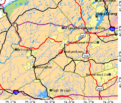
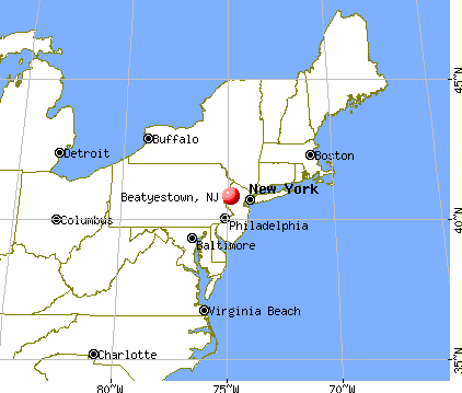
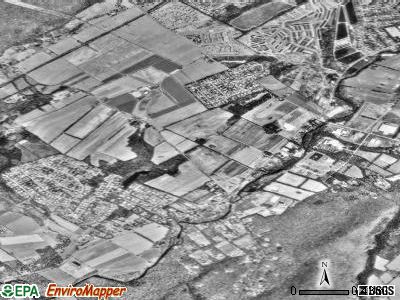
Beatyestown, New Jersey
Submit your own pictures of this place and show them to the world
- OSM Map
- General Map
- Google Map
- MSN Map
| Males: 1,684 | |
| Females: 1,749 |
| Median resident age: | 34.8 years |
| New Jersey median age: | 36.7 years |
Zip codes: 07840.
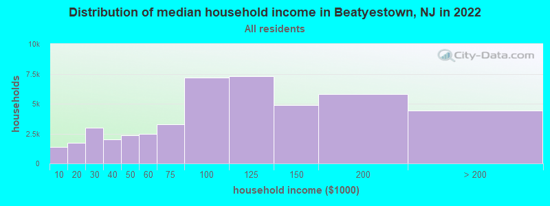
| Beatyestown: | $99,584 |
| NJ: | $96,346 |
Estimated per capita income in 2022: $51,541 (it was $29,345 in 2000)
Beatyestown CDP income, earnings, and wages data
Estimated median house or condo value in 2022: $391,624 (it was $175,000 in 2000)
| Beatyestown: | $391,624 |
| NJ: | $428,900 |
Mean prices in 2022: all housing units: $362,312; detached houses: $388,036; townhouses or other attached units: $251,855; in 2-unit structures: $306,310; in 3-to-4-unit structures: $224,712; in 5-or-more-unit structures: $211,810; mobile homes: $102,069
Detailed information about poverty and poor residents in Beatyestown, NJ
Compare current foreclosures near Beatyestown, NJ:
| Photo | Address | Area | Beds / Baths | Price | Details |
|---|---|---|---|---|---|

|
#1
River Styx Rd
Hopatcong, NJ 07843
|
1,389 sq. feet
|
1 baths 3 beds |
$123,900
|
show details |

|
#2
Stony Brook Rd
Blairstown, NJ 07825
|
2,864 sq. feet
|
2 baths 4 beds |
$588,500
|
show details |

|
#3
Millbrook Rd
Blairstown, NJ 07825
|
1,248 sq. feet
|
1 baths 4 beds |
$260,000
|
show details |

|
#4
Us Highway 46
Columbia, NJ 07832
|
1,012 sq. feet
|
1 baths 2 beds |
$344,900
|
show details |

|
#5
Bucknell Trl
Hopatcong, NJ 07843
|
672 sq. feet
|
1 baths 2 beds |
$279,900
|
show details |

|
#6
Buckley Ave
Oxford, NJ 07863
|
1,872 sq. feet
|
1 baths 3 beds |
$450,000
|
show details |

|
#7
Hill St
Washington, NJ 07882
|
2,418 sq. feet
|
2 baths 5 beds |
$322,500
|
show details |

|
#8
Ironia Rd
Mendham, NJ 07945
|
5,025 sq. feet
|
4 baths 5 beds |
show details | |

|
#9
Slateford Rd
Mount Bethel, PA 18343
|
1,088 sq. feet
|
1 baths 2 beds |
show details | |

|
#10
Washington St # C
Stewartsville, NJ 08886
|
4,364 sq. feet
|
3 baths 8 beds |
show details |
| Photo | Address | Area | Beds / Baths | Price | Details |
|---|---|---|---|---|---|

|
#11
Garden Ct
Succasunna, NJ 07876
|
1,150 sq. feet
|
1 baths 2 beds |
show details | |

|
#12
Axford Ave
Oxford, NJ 07863
|
1,040 sq. feet
|
1 baths 3 beds |
show details | |

|
#13
Ka Ton Nah Trl
Andover, NJ 07821
|
966 sq. feet
|
1 baths 2 beds |
show details | |

|
#14
Stanton Lebanon Rd
Lebanon, NJ 08833
|
2,817 sq. feet
|
3 baths 4 beds |
show details | |

|
#15
Aspen Ct
Stanhope, NJ 07874
|
861 sq. feet
|
1 baths 1 beds |
show details | |

|
#16
Rt 206
Andover, NJ 07821
|
- sq. feet
|
2 baths 4 beds |
show details | |

|
#17
Carlisle Ct
Chester, NJ 07930
|
5,735 sq. feet
|
5 baths 4 beds |
show details | |

|
#18
Kensington Ct
Morristown, NJ 07960
|
4,424 sq. feet
|
6 baths 6 beds |
show details | |

|
#19
Koclas Dr
Netcong, NJ 07857
|
2,050 sq. feet
|
3 baths 5 beds |
show details | |

|
#20
Center St
Clinton, NJ 08809
|
1,824 sq. feet
|
1 baths 2 beds |
show details |
| Photo | Address | Area | Beds / Baths | Price | Details |
|---|---|---|---|---|---|

|
#21
Cliffwood Rd
Chester, NJ 07930
|
3,486 sq. feet
|
2 baths 4 beds |
show details | |

|
#22
Birch Pkwy
Sparta, NJ 07871
|
1,792 sq. feet
|
3 baths 3 beds |
show details | |

|
#23
Sand Shore Rd
Budd Lake, NJ 07828
|
936 sq. feet
|
1 baths 2 beds |
show details | |

|
#24
Rollins Trl
Hopatcong, NJ 07843
|
2,251 sq. feet
|
2 baths 3 beds |
show details | |

|
#25
Stone Hedge Rd
Belvidere, NJ 07823
|
2,596 sq. feet
|
3 baths 4 beds |
show details | |

|
#26
W Baldwin St
Hackettstown, NJ 07840
|
1,778 sq. feet
|
2 baths 3 beds |
show details | |

|
#27
Budd Ave
Budd Lake, NJ 07828
|
816 sq. feet
|
1 baths 2 beds |
show details | |

|
#28
Vivian Plz
Newton, NJ 07860
|
1,776 sq. feet
|
2 baths 3 beds |
show details | |

|
#29
Tamarack Rd
Andover, NJ 07821
|
1,250 sq. feet
|
1 baths 2 beds |
show details | |

|
#30
Tamarack Rd
Belvidere, NJ 07823
|
3,466 sq. feet
|
2 baths 4 beds |
show details |
| Photo | Address | Area | Beds / Baths | Price | Details |
|---|---|---|---|---|---|

|
#31
Hutchins Ln
Randolph, NJ 07869
|
3,731 sq. feet
|
3 baths 4 beds |
show details | |

|
#32
Shores Rd
Brookside, NJ 07926
|
- sq. feet
|
2 baths 4 beds |
show details | |

|
#33
Lois Ln
Bangor, PA 18013
|
1,556 sq. feet
|
2 baths 3 beds |
show details | |

|
#34
Pleasant View Rd
Bangor, PA 18013
|
1,184 sq. feet
|
1 baths 2 beds |
show details | |

|
#35
Potomac St
Mount Bethel, PA 18343
|
2,672 sq. feet
|
2 baths 4 beds |
show details | |

|
#36
Berry Hollow Rd
Bangor, PA 18013
|
1,894 sq. feet
|
2 baths 3 beds |
show details | |

|
#37
Gravel Hill Rd
Bangor, PA 18013
|
1,138 sq. feet
|
1 baths 3 beds |
show details | |

|
#38
Summerfield Dr
Mount Bethel, PA 18343
|
2,656 sq. feet
|
2 baths 4 beds |
show details | |

|
#39
Potomac St
Mount Bethel, PA 18343
|
1,624 sq. feet
|
1 baths 4 beds |
show details | |

|
#40
Red Fox Ln
Mount Bethel, PA 18343
|
3,429 sq. feet
|
3 baths 4 beds |
show details |
| Photo | Address | Area | Beds / Baths | Price | Details |
|---|---|---|---|---|---|

|
#41
Shores Rd
Randolph, NJ 07869
|
3,434 sq. feet
|
- baths - beds |
show details | |

|
#42
Scenic Dr
Newton, NJ 07860
|
1,908 sq. feet
|
- baths - beds |
show details | |

|
#43
State Route 94
Columbia, NJ 07832
|
1,223 sq. feet
|
- baths - beds |
show details | |

|
#44
James Dr
Mount Arlington, NJ 07856
|
3,004 sq. feet
|
- baths - beds |
show details | |

|
#45
Sanatorium Rd
Glen Gardner, NJ 08826
|
846 sq. feet
|
- baths - beds |
show details | |

|
#46
Marsh Hawk # 2
Hackettstown, NJ 07840
|
552 sq. feet
|
1 baths - beds |
show details | |

|
#47
Tulsa Trl
Hopatcong, NJ 07843
|
884 sq. feet
|
- baths - beds |
show details | |

|
#48
Maple Path
Landing, NJ 07850
|
1,204 sq. feet
|
- baths - beds |
show details | |

|
#49
Schindler Ct
Newton, NJ 07860
|
3,877 sq. feet
|
- baths - beds |
show details | |

|
Check over 1 million property listings on Foreclosure.com!
|
browse all offers | |||

- 2,82687.7%White alone
- 2106.5%Hispanic
- 601.9%Asian alone
- 591.8%Two or more races
- 531.6%Black alone
- 140.4%Other race alone
- 10.03%American Indian alone
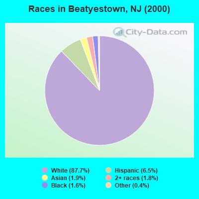
Races in Beatyestown detailed stats: ancestries, foreign born residents, place of birth
 Recent articles from our blog. Our writers, many of them Ph.D. graduates or candidates, create easy-to-read articles on a wide variety of topics.

 | Sussex/Warren/Morris towns "missing" from City Data (2 replies) |
Ancestries: Italian (21.7%), German (21.1%), Irish (16.2%), Polish (8.8%), English (6.8%), United States (5.0%).
Current Local Time: EST time zone
Land area: 3.01 square miles.
Population density: 1,141 people per square mile (low).
245 residents are foreign born (3.9% Latin America, 2.4% Asia, 1.3% Europe).
| This place: | 7.6% |
| New Jersey: | 17.5% |
| Beatyestown CDP: | 2.6% ($4,473) |
| New Jersey: | 2.4% ($4,047) |
Nearest city with pop. 50,000+: Bethlehem, PA  (30.9 miles , pop. 71,329).
Nearest city with pop. 200,000+: Newark, NJ (35.1 miles , pop. 273,546).
Nearest city with pop. 1,000,000+: Manhattan, NY (45.8 miles , pop. 1,537,195).
Nearest cities:
), ), ), ), )Latitude: 40.82 N, Longitude: 74.84 W
Area code commonly used in this area: 908
| Here: | 4.1% |
| New Jersey: | 4.5% |
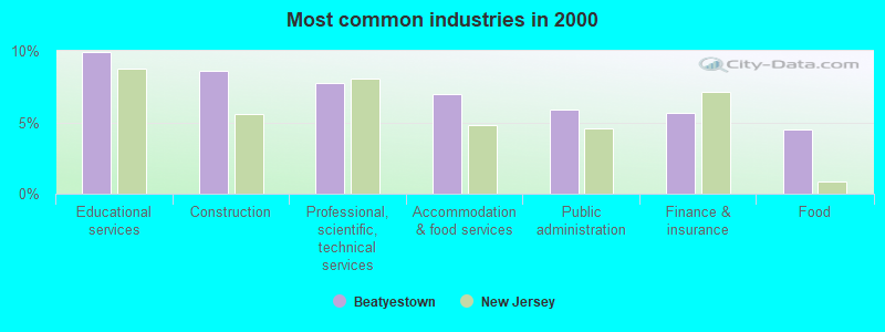
- Educational services (10.0%)
- Construction (8.6%)
- Professional, scientific, technical services (7.8%)
- Accommodation & food services (7.0%)
- Public administration (5.9%)
- Finance & insurance (5.7%)
- Food (4.5%)
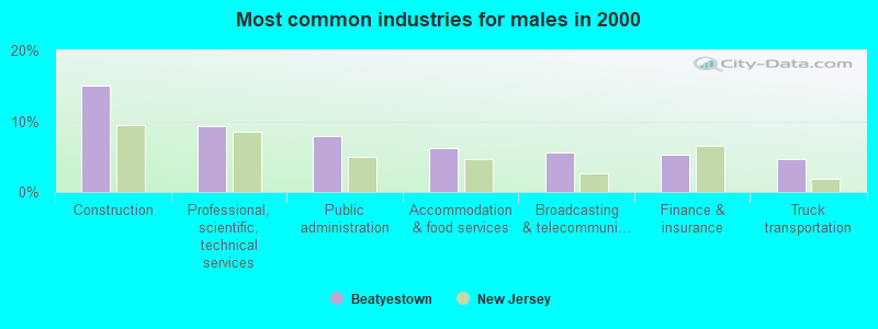
- Construction (15.1%)
- Professional, scientific, technical services (9.3%)
- Public administration (7.9%)
- Accommodation & food services (6.2%)
- Broadcasting & telecommunications (5.6%)
- Finance & insurance (5.2%)
- Truck transportation (4.7%)
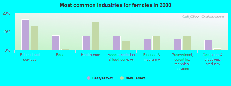
- Educational services (16.6%)
- Food (8.1%)
- Health care (7.7%)
- Accommodation & food services (7.7%)
- Finance & insurance (6.2%)
- Professional, scientific, technical services (6.2%)
- Computer & electronic products (5.7%)
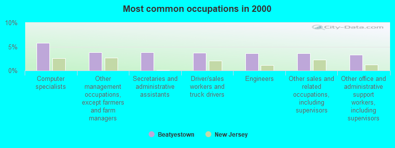
- Computer specialists (5.8%)
- Other management occupations, except farmers and farm managers (3.9%)
- Secretaries and administrative assistants (3.8%)
- Driver/sales workers and truck drivers (3.7%)
- Engineers (3.6%)
- Other sales and related occupations, including supervisors (3.6%)
- Other office and administrative support workers, including supervisors (3.3%)
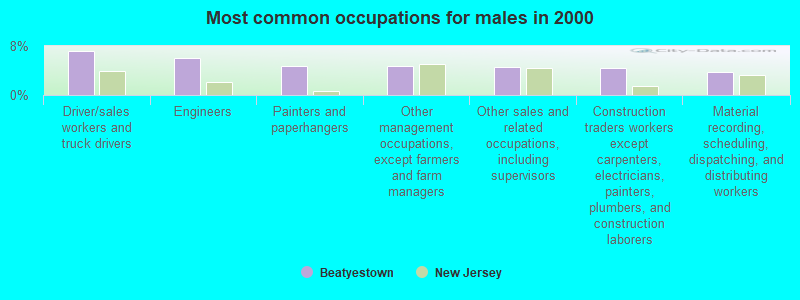
- Driver/sales workers and truck drivers (7.1%)
- Engineers (6.0%)
- Painters and paperhangers (4.8%)
- Other management occupations, except farmers and farm managers (4.8%)
- Other sales and related occupations, including supervisors (4.6%)
- Construction traders workers except carpenters, electricians, painters, plumbers, and construction laborers (4.5%)
- Material recording, scheduling, dispatching, and distributing workers (3.7%)
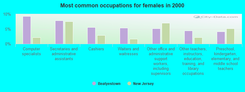
- Computer specialists (9.3%)
- Secretaries and administrative assistants (7.8%)
- Cashiers (5.6%)
- Waiters and waitresses (5.3%)
- Other office and administrative support workers, including supervisors (5.1%)
- Other teachers, instructors, education, training, and library occupations (4.4%)
- Preschool, kindergarten, elementary, and middle school teachers (4.2%)
Average climate in Beatyestown, New Jersey
Based on data reported by over 4,000 weather stations


(lower is better)
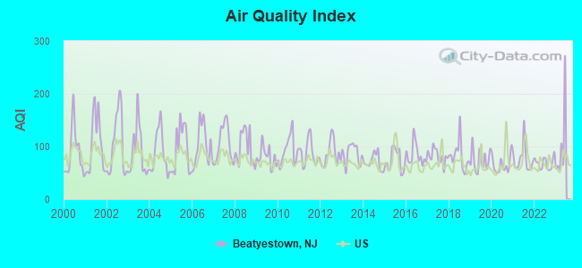
Air Quality Index (AQI) level in 2022 was 68.3. This is about average.
| City: | 68.3 |
| U.S.: | 72.6 |
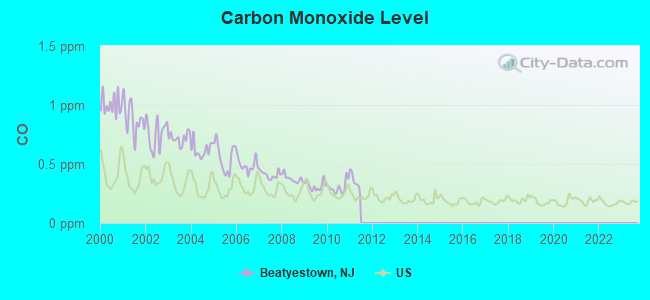
Carbon Monoxide (CO) [ppm] level in 2010 was 0.301. This is about average. Closest monitor was 19.0 miles away from the city center.
| City: | 0.301 |
| U.S.: | 0.251 |
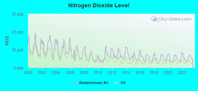
Nitrogen Dioxide (NO2) [ppb] level in 2022 was 5.30. This is about average. Closest monitor was 9.1 miles away from the city center.
| City: | 5.30 |
| U.S.: | 5.11 |
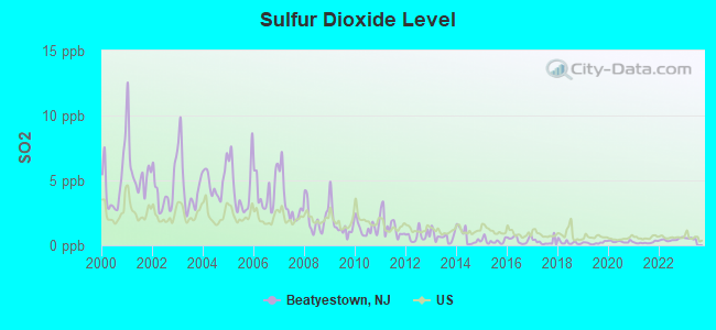
Sulfur Dioxide (SO2) [ppb] level in 2022 was 0.437. This is significantly better than average. Closest monitor was 9.1 miles away from the city center.
| City: | 0.437 |
| U.S.: | 1.515 |
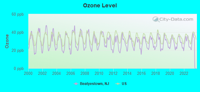
Ozone [ppb] level in 2022 was 28.8. This is about average. Closest monitor was 9.1 miles away from the city center.
| City: | 28.8 |
| U.S.: | 33.3 |
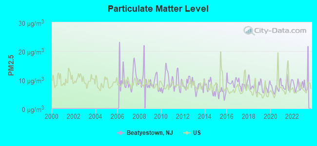
Particulate Matter (PM2.5) [µg/m3] level in 2022 was 8.03. This is about average. Closest monitor was 9.1 miles away from the city center.
| City: | 8.03 |
| U.S.: | 8.11 |
Tornado activity:
Beatyestown-area historical tornado activity is slightly above New Jersey state average. It is 20% smaller than the overall U.S. average.
On 5/28/1973, a category F3 (max. wind speeds 158-206 mph) tornado 6.9 miles away from the Beatyestown place center injured 12 people and caused between $50,000 and $500,000 in damages.
On 5/28/1973, a category F3 tornado 18.1 miles away from the place center caused between $50,000 and $500,000 in damages.
Earthquake activity:
Beatyestown-area historical earthquake activity is significantly above New Jersey state average. It is 67% smaller than the overall U.S. average.On 8/23/2011 at 17:51:04, a magnitude 5.8 (5.8 MW, Depth: 3.7 mi, Class: Moderate, Intensity: VI - VII) earthquake occurred 260.4 miles away from Beatyestown center
On 1/16/1994 at 01:49:16, a magnitude 4.6 (4.6 MB, 4.6 LG, Depth: 3.1 mi, Class: Light, Intensity: IV - V) earthquake occurred 71.2 miles away from the city center
On 10/7/1983 at 10:18:46, a magnitude 5.3 (5.1 MB, 5.3 LG, 5.1 ML) earthquake occurred 218.2 miles away from the city center
On 4/20/2002 at 10:50:47, a magnitude 5.3 (5.3 ML, Depth: 3.0 mi) earthquake occurred 262.0 miles away from Beatyestown center
On 4/20/2002 at 10:50:47, a magnitude 5.2 (5.2 MB, 4.2 MS, 5.2 MW, 5.0 MW) earthquake occurred 260.0 miles away from the city center
On 1/16/1994 at 00:42:43, a magnitude 4.2 (4.2 MB, 4.0 LG, Depth: 3.1 mi) earthquake occurred 69.9 miles away from the city center
Magnitude types: regional Lg-wave magnitude (LG), body-wave magnitude (MB), local magnitude (ML), surface-wave magnitude (MS), moment magnitude (MW)
Natural disasters:
The number of natural disasters in Warren County (22) is greater than the US average (15).Major Disasters (Presidential) Declared: 13
Emergencies Declared: 9
Causes of natural disasters: Hurricanes: 6, Floods: 4, Storms: 4, Blizzards: 2, Snowstorms: 2, Water Shortages: 2, Heavy Rain: 1, Tropical Depression: 1, Tropical Storm: 1, Winter Storm: 1, Other: 3 (Note: some incidents may be assigned to more than one category).
Hospitals and medical centers near Beatyestown:
- HEATH VILLAGE (Nursing Home, about 2 miles away; HACKETTSTOWN, NJ)
- HACKETTSTOWN REGIONAL MEDICAL CENTER Acute Care Hospitals (about 4 miles away; HACKETTSTOWN, NJ)
- DAVITA HACKETTSTOWN DC (Dialysis Facility, about 4 miles away; HACKETTSTOWN, NJ)
- HOUSE OF THE GOOD SHEPHERD (Nursing Home, about 4 miles away; HACKETTSTOWN, NJ)
- WARREN HAVEN (Nursing Home, about 6 miles away; OXFORD, NJ)
- LITTLE BROOK NURSING AND CONVALESCENT HOME (Nursing Home, about 6 miles away; CALIFON, NJ)
- WARREN COUNTY PUBLIC HEALTH NURSING AGENCY (Home Health Center, about 9 miles away; WASHINGTON, NJ)
Colleges/universities with over 2000 students nearest to Beatyestown:
- Centenary College (about 3 miles; Hackettstown, NJ; Full-time enrollment: 2,271)
- County College of Morris (about 15 miles; Randolph, NJ; FT enrollment: 6,427)
- Raritan Valley Community College (about 17 miles; Branchburg, NJ; FT enrollment: 5,735)
- Sussex County Community College (about 18 miles; Newton, NJ; FT enrollment: 2,402)
- Lafayette College (about 21 miles; Easton, PA; FT enrollment: 2,562)
- East Stroudsburg University of Pennsylvania (about 22 miles; East Stroudsburg, PA; FT enrollment: 6,195)
- Fairleigh Dickinson University-College at Florham (about 22 miles; Madison, NJ; FT enrollment: 2,690)
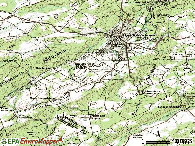
Points of interest:
Notable locations in Beatyestown: Hackettstown Fish Hatchery (A), Donaldson Farms (B), Mansfield Emergency Medical Services (C), Tri - County Volunteer Fire Company (D). Display/hide their locations on the map
Streams, rivers, and creeks: Hances Brook (A). Display/hide its location on the map
Park in Beatyestown: Rockport Game Farm (1). Display/hide its location on the map
| This place: | 2.6 people |
| New Jersey: | 2.7 people |
| This place: | 70.8% |
| Whole state: | 70.7% |
| This place: | 6.6% |
| Whole state: | 4.9% |
Likely homosexual households (counted as self-reported same-sex unmarried-partner households)
- Lesbian couples: 0.5% of all households
- Gay men: 0.0% of all households
| This place: | 2.3% |
| Whole state: | 8.5% |
| This place: | 0.7% |
| Whole state: | 4.2% |
For population 15 years and over in Beatyestown:
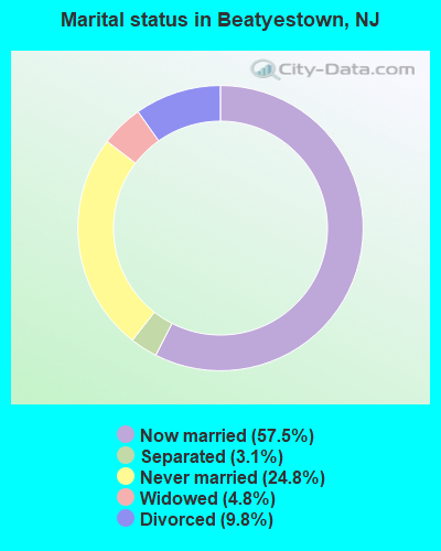
- Never married: 24.8%
- Now married: 57.5%
- Separated: 3.1%
- Widowed: 4.8%
- Divorced: 9.8%
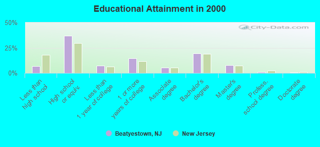
For population 25 years and over in Beatyestown:
- High school or higher: 93.2%
- Bachelor's degree or higher: 29.0%
- Graduate or professional degree: 9.5%
- Unemployed: 2.4%
- Mean travel time to work (commute): 30.7 minutes
| Here: | 9.1 |
| New Jersey average: | 13.1 |
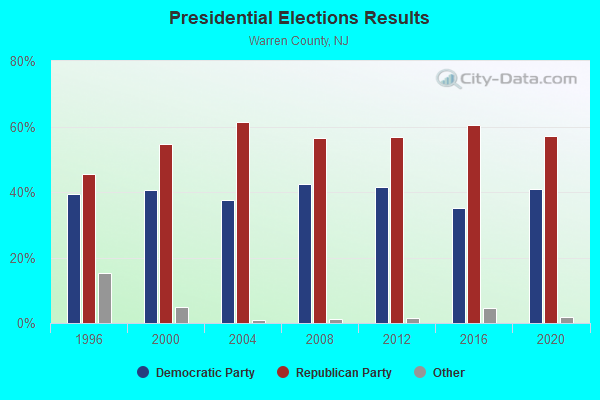
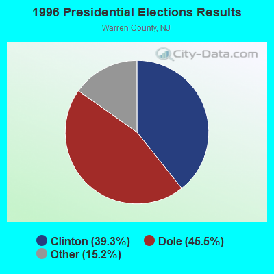
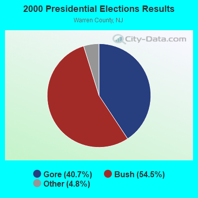
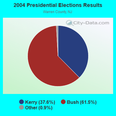
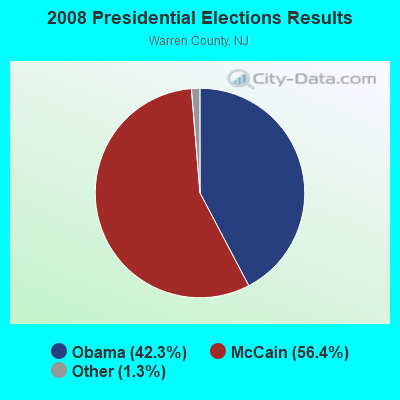
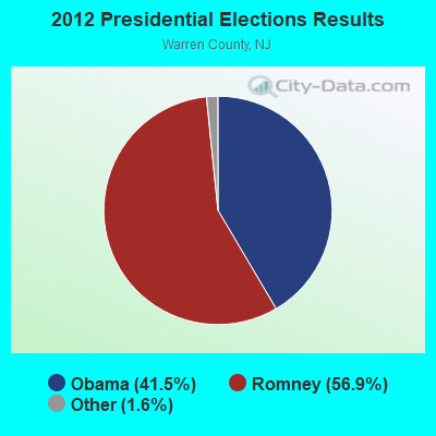
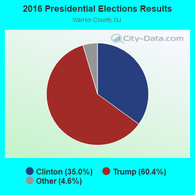
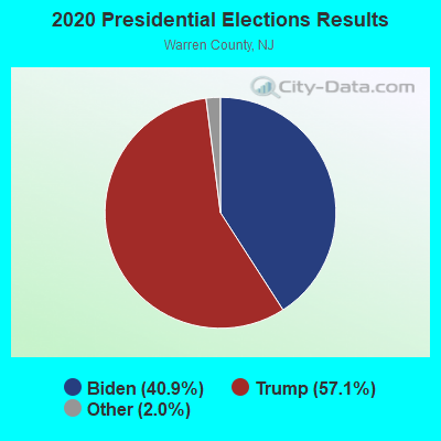
Graphs represent county-level data. Detailed 2008 Election Results
Religion statistics for Beatyestown, NJ (based on Warren County data)
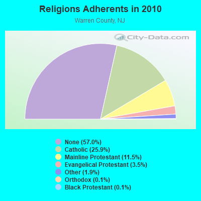
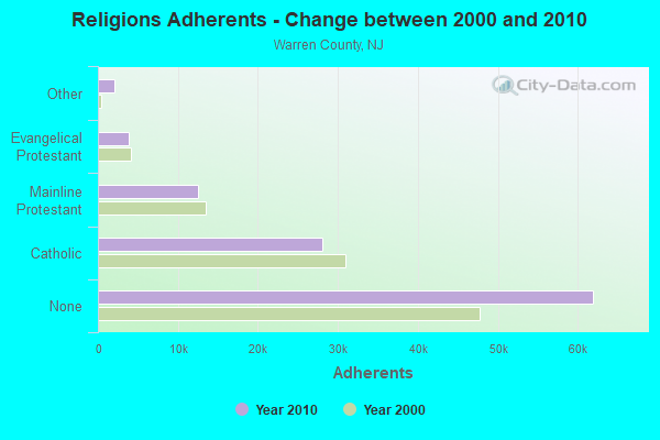
| Religion | Adherents | Congregations |
|---|---|---|
| Catholic | 28,114 | 11 |
| Mainline Protestant | 12,512 | 49 |
| Evangelical Protestant | 3,805 | 32 |
| Other | 2,040 | 10 |
| Orthodox | 150 | 2 |
| Black Protestant | 122 | 1 |
| None | 61,949 | - |
Food Environment Statistics:
| Here: | 2.28 / 10,000 pop. |
| New Jersey: | 2.90 / 10,000 pop. |
| This county: | 1.92 / 10,000 pop. |
| New Jersey: | 1.76 / 10,000 pop. |
| This county: | 1.28 / 10,000 pop. |
| New Jersey: | 0.81 / 10,000 pop. |
| This county: | 6.12 / 10,000 pop. |
| New Jersey: | 7.15 / 10,000 pop. |
| This county: | 8.4% |
| State: | 8.3% |
| Warren County: | 26.9% |
| New Jersey: | 23.3% |
| Warren County: | 14.1% |
| New Jersey: | 18.0% |
Strongest AM radio stations in Beatyestown:
- WRNJ (1510 AM; 2 kW; HACKETTSTOWN, NJ; Owner: WRNJ RADIO, INC.)
- WWJZ (640 AM; 50 kW; MOUNT HOLLY, NJ; Owner: ABC, INC.)
- WMCA (570 AM; 50 kW; NEW YORK, NY; Owner: SALEM MEDIA OF NEW YORK, LLC)
- WOR (710 AM; 50 kW; NEW YORK, NY; Owner: BUCKLEY BROADCASTING CORPORATION)
- WABC (770 AM; 50 kW; NEW YORK, NY; Owner: WABC-AM RADIO, INC.)
- WSNR (620 AM; 20 kW; JERSEY CITY, NJ)
- WINS (1010 AM; 50 kW; NEW YORK, NY; Owner: INFINITY BROADCASTING OPERATIONS, INC.)
- WEPN (1050 AM; 50 kW; NEW YORK, NY; Owner: NEW YORK AM RADIO, LLC)
- WBBR (1130 AM; 50 kW; NEW YORK, NY; Owner: BLOOMBERG COMMUNICATIONS INC.)
- WADO (1280 AM; 50 kW; NEW YORK, NY; Owner: WADO-AM LICENSE CORP.)
- WFAN (660 AM; 50 kW; NEW YORK, NY; Owner: INFINITY BROADCASTING OPERATIONS, INC.)
- WCBS (880 AM; 50 kW; NEW YORK, NY; Owner: INFINITY BROADCASTING OPERATIONS, INC.)
- WLIB (1190 AM; 30 kW; NEW YORK, NY; Owner: ICBC BROADCAST HOLDINGS-NY, INC.)
Strongest FM radio stations in Beatyestown:
- W284AF (104.7 FM; HACKETTSTOWN, NJ; Owner: WRNJ RADIO, INC.)
- W224AS (92.7 FM; WASHINGTON, NJ; Owner: WRNJ RADIO, INC.)
- W245AC (96.9 FM; HARMONY TOWNSHIP, NJ; Owner: MERCER COUNTY COMMUNITY COLLEGE)
- W289AA (105.7 FM; LEBANON TOWNSHIP, NJ; Owner: MERCER COUNTY COMMUNITY COLLEGE)
- WHCY (106.3 FM; BLAIRSTOWN, NJ; Owner: CLEAR CHANNEL BROADCASTING LICENSES, INC.)
- WWPJ (89.5 FM; PEN ARGYL, PA; Owner: MERCER COUNTY COMMUNITY COLLEGE)
- WNNJ-FM (103.7 FM; NEWTON, NJ; Owner: CLEAR CHANNEL BROADCASTING LICENSES, INC.)
- WSBG (93.5 FM; STROUDSBURG, PA; Owner: NASSAU BROADCASTING II, L.L.C.)
- WWYY (107.1 FM; BELVIDERE, NJ; Owner: NASSAU BROADCASTING HOLDINGS, INC.)
- WAWZ (99.1 FM; ZAREPHATH, NJ; Owner: PILLAR OF FIRE)
- WRKS (98.7 FM; NEW YORK, NY; Owner: EMMIS RADIO LICENSE CORP OF NEW YORK)
- WDHA-FM (105.5 FM; DOVER, NJ; Owner: THE SENTINEL PUBLISHING CO.)
- WNEW (102.7 FM; NEW YORK, NY; Owner: INFINITY BROADCASTING OPERATIONS, INC.)
- WNYC-FM (93.9 FM; NEW YORK, NY; Owner: WNYC RADIO)
- WCVH (90.5 FM; FLEMINGTON, NJ; Owner: HUNTERDON CENTRAL H. S. BD. OF EDUC.)
- WPAT-FM (93.1 FM; PATERSON, NJ; Owner: WPAT LICENSING, INC.)
- WLEV (100.7 FM; ALLENTOWN, PA; Owner: CITADEL BROADCASTING COMPANY)
- WSUS (102.3 FM; FRANKLIN, NJ; Owner: CLEAR CHANNEL BROADCASTING LICENSES, INC.)
- WQCD (101.9 FM; NEW YORK, NY; Owner: EMMIS RADIO LICENSE CORPORATION)
- WKTU (103.5 FM; LAKE SUCCESS, NY; Owner: AMFM RADIO LICENSES, LLC)
TV broadcast stations around Beatyestown:
- W49BE (Channel 49; HACKETTSTOWN, NJ; Owner: NEW JERSEY PUBLIC B/CING. AUTHORITY)
- W23AZ (Channel 23; HACKETTSTOWN, NJ; Owner: CENTENARY COLLEGE)
- WNYW (Channel 5; NEW YORK, NY; Owner: FOX TELEVISION STATIONS, INC.)
- WMBC-TV (Channel 63; NEWTON, NJ; Owner: MOUNTAIN BROADCASTING CORPORATION)
- WCBS-TV (Channel 2; NEW YORK, NY; Owner: CBS BROADCASTING INC.)
- WABC-TV (Channel 7; NEW YORK, NY; Owner: AMERICAN BROADCASTING COMPANIES, INC)
- WPIX (Channel 11; NEW YORK, NY; Owner: WPIX, INC.)
- WWOR-TV (Channel 9; SECAUCUS, NJ; Owner: FOX TELEVISION STATIONS, INC.)
- WPXO-LP (Channel 34; EAST ORANGE, NJ; Owner: PAXSON COMMUNICATIONS LPTV, INC.)
- WPXN-TV (Channel 31; NEW YORK, NY; Owner: PAXSON COMMUNICATIONS LICENSE COMPANY, LLC)
- WNBC (Channel 4; NEW YORK, NY; Owner: NATIONAL BROADCASTING COMPANY, INC.)
- WNET (Channel 13; NEWARK, NJ; Owner: EDUCATIONAL BROADCASTING CORPORATION)
- WXTV (Channel 41; PATERSON, NJ; Owner: WXTV LICENSE PARTNERSHIP, G.P.)
- WNJU (Channel 47; LINDEN, NJ; Owner: WNJU LICENSE CORPORATION)
- WFUT (Channel 68; NEWARK, NJ; Owner: UNIVISION NEW YORK LLC)
- W54CZ (Channel 54; MORRISTOWN, NJ; Owner: WLNY-TV, INC.)
- WNYE-TV (Channel 25; NEW YORK, NY; Owner: NEW YORK CITY BOARD OF EDUCATION)
- WXNY-LP (Channel 32; NEW YORK, NY; Owner: ISLAND BROADCASTING COMPANY)
- W55BS (Channel 55; BELVIDERE, NJ; Owner: NEW JERSEY PUBLIC BROADCASTING AUTHORITY)
- WNJT (Channel 52; TRENTON, NJ; Owner: NEW JERSEY PUBLIC BROADCASTING AUTHORITY)
- WKOB-LP (Channel 53; NEW YORK, NY; Owner: WKOB COMMUNICATIONS, INC.)
- WEBR-CA (Channel 17; MANHATTAN, NY; Owner: K LICENSEE INC.)
- WRNN-LP (Channel 57; NYACK, NY; Owner: LP NYACK LIMITED PARTNERSHIP)
- WFME-TV (Channel 66; WEST MILFORD, NJ; Owner: FAMILY STATIONS, INC.)
- WNJB (Channel 58; NEW BRUNSWICK, NJ; Owner: NEW JERSEY PUBLIC BROADCASTING AUTHORITY)
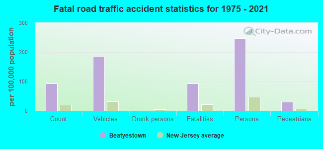
Beatyestown fatal accident list:
Dec 5, 2016 03:35 PM, Sr-57, Lat: 40.823458, Lon: -74.834725, Vehicles: 1, Persons: 1, Pedestrians: 1, Fatalities: 1
May 25, 2005 11:32 PM, Sr-57, Hazen Rd, Lat: 40.806160, Lon: -74.857320, Vehicles: 2, Persons: 2, Fatalities: 1
- National Bridge Inventory (NBI) Statistics
- 2Number of bridges
- 10ft / 3.1mTotal length
- $8,000Total costs
- 19,146Total average daily traffic
- 685Total average daily truck traffic
- 23,135Total future (year 2040) average daily traffic
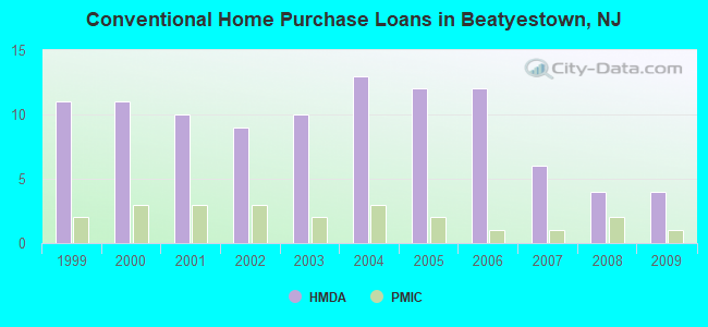
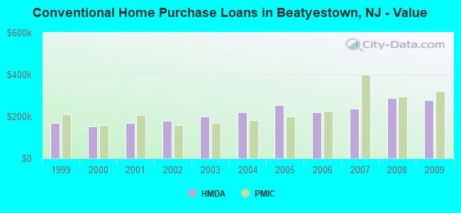
| Home Mortgage Disclosure Act Aggregated Statistics For Year 2009 (Based on 1 partial tract) | ||||||||||
| A) FHA, FSA/RHS & VA Home Purchase Loans | B) Conventional Home Purchase Loans | C) Refinancings | D) Home Improvement Loans | F) Non-occupant Loans on < 5 Family Dwellings (A B C & D) | ||||||
|---|---|---|---|---|---|---|---|---|---|---|
| Number | Average Value | Number | Average Value | Number | Average Value | Number | Average Value | Number | Average Value | |
| LOANS ORIGINATED | 2 | $361,810 | 4 | $278,830 | 16 | $215,959 | 1 | $91,200 | 1 | $135,360 |
| APPLICATIONS APPROVED, NOT ACCEPTED | 0 | $0 | 0 | $0 | 1 | $243,300 | 0 | $0 | 0 | $0 |
| APPLICATIONS DENIED | 0 | $0 | 0 | $0 | 8 | $266,121 | 1 | $70,660 | 0 | $0 |
| APPLICATIONS WITHDRAWN | 0 | $0 | 0 | $0 | 4 | $227,430 | 0 | $0 | 0 | $0 |
| FILES CLOSED FOR INCOMPLETENESS | 0 | $0 | 0 | $0 | 1 | $250,900 | 0 | $0 | 0 | $0 |
Detailed HMDA statistics for the following Tracts: 0315.00
| Private Mortgage Insurance Companies Aggregated Statistics For Year 2009 (Based on 1 partial tract) | ||
| A) Conventional Home Purchase Loans | ||
|---|---|---|
| Number | Average Value | |
| LOANS ORIGINATED | 1 | $321,860 |
| APPLICATIONS APPROVED, NOT ACCEPTED | 1 | $397,860 |
| APPLICATIONS DENIED | 1 | $260,040 |
| APPLICATIONS WITHDRAWN | 0 | $0 |
| FILES CLOSED FOR INCOMPLETENESS | 0 | $0 |
Detailed PMIC statistics for the following Tracts: 0315.00
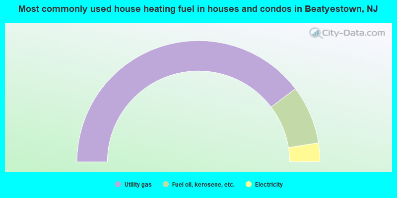
- 79.4%Utility gas
- 15.6%Fuel oil, kerosene, etc.
- 5.0%Electricity
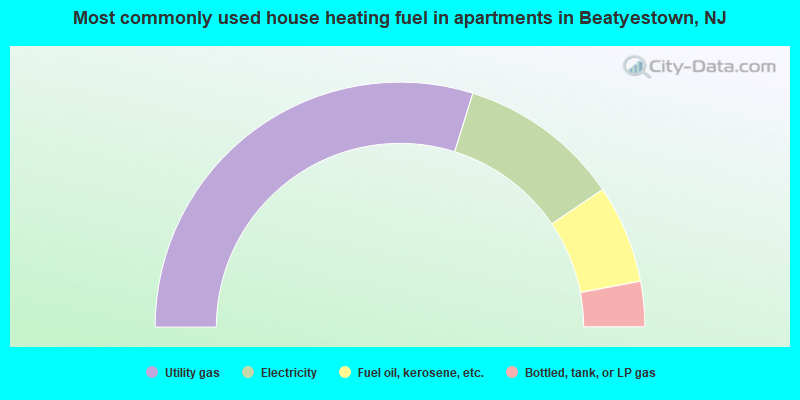
- 59.7%Utility gas
- 21.4%Electricity
- 13.0%Fuel oil, kerosene, etc.
- 6.0%Bottled, tank, or LP gas
Beatyestown compared to New Jersey state average:
- Unemployed percentage significantly below state average.
- Black race population percentage significantly below state average.
- Hispanic race population percentage significantly below state average.
- Median age below state average.
- Foreign-born population percentage significantly below state average.
- Renting percentage significantly below state average.
- Length of stay since moving in significantly above state average.
- Number of rooms per house significantly below state average.
- House age significantly below state average.
Beatyestown on our top lists:
- #29 on the list of "Top 101 cities with the most residents born in Chile (population 500+)"
- #4 on the list of "Top 101 counties with the lowest Ozone (1-hour) air pollution readings in 2012 (ppm)"
- #18 on the list of "Top 101 counties with the largest decrease in the number of births per 1000 residents 2000-2006 to 2007-2013 (pop 50,000+)"
- #32 on the list of "Top 101 counties with the highest percentage of residents that smoked 100+ cigarettes in their lives"
- #43 on the list of "Top 101 counties with the lowest surface withdrawal of fresh water for public supply (pop. 50,000+)"
- #54 on the list of "Top 101 counties with the lowest number of births per 1000 residents 2007-2013"