Hermantown, Minnesota
Submit your own pictures of this city and show them to the world
- OSM Map
- General Map
- Google Map
- MSN Map
Population change since 2000: +36.0%
| Males: 5,139 | |
| Females: 4,987 |
| Median resident age: | 38.0 years |
| Minnesota median age: | 39.0 years |
Zip codes: 55814.
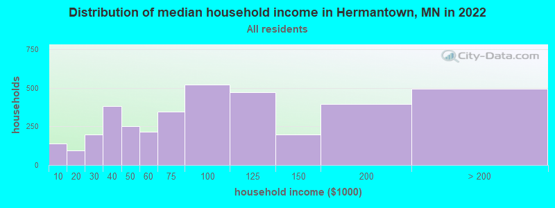
| Hermantown: | $80,552 |
| MN: | $82,338 |
Estimated per capita income in 2022: $46,512 (it was $20,993 in 2000)
Hermantown city income, earnings, and wages data
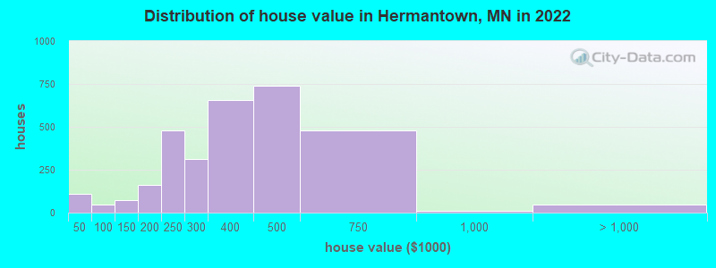
Estimated median house or condo value in 2022: $381,562 (it was $104,700 in 2000)
| Hermantown: | $381,562 |
| MN: | $314,600 |
Mean prices in 2022: all housing units: $385,018; detached houses: $411,542; townhouses or other attached units: $424,499; mobile homes: $47,766
Median gross rent in 2022: $1,225.
(4.7% for White Non-Hispanic residents, 1.9% for Black residents, 92.3% for American Indian residents, 1.5% for two or more races residents)
Detailed information about poverty and poor residents in Hermantown, MN
Compare current foreclosures near Hermantown, MN:
| Photo | Address | Area | Beds / Baths | Price | Details |
|---|---|---|---|---|---|

|
#1
Baxter Ave
Superior, WI 54880
|
- sq. feet
|
1 baths 2 beds |
$57,200
|
show details |

|
#2
Kissell Ave
Duluth, MN 55811
|
852 sq. feet
|
- baths 2 beds |
$129,900
|
show details |

|
#3
105th Ave W
Duluth, MN 55808
|
960 sq. feet
|
1 baths 2 beds |
show details | |

|
#4
S 66th Ave W
Duluth, MN 55807
|
768 sq. feet
|
1 baths 2 beds |
show details | |

|
#5
W 4th St
Duluth, MN 55806
|
1,381 sq. feet
|
1 baths 4 beds |
show details | |

|
#6
W 3rd St
Duluth, MN 55806
|
1,528 sq. feet
|
1 baths 3 beds |
show details | |

|
#7
E 7th St
Duluth, MN 55805
|
1,436 sq. feet
|
1 baths 3 beds |
show details | |

|
#8
W 8th St
Duluth, MN 55807
|
983 sq. feet
|
1 baths 2 beds |
show details | |

|
#9
105th Ave W
Duluth, MN 55808
|
- sq. feet
|
1 baths 4 beds |
show details | |

|
#10
Selmser Ave
Cloquet, MN 55720
|
1,200 sq. feet
|
1 baths 4 beds |
show details |
| Photo | Address | Area | Beds / Baths | Price | Details |
|---|---|---|---|---|---|

|
#11
W Buffalo St
Duluth, MN 55811
|
1,155 sq. feet
|
1 baths 2 beds |
show details | |

|
#12
Highway 194
Saginaw, MN 55779
|
732 sq. feet
|
1 baths 2 beds |
show details | |

|
#13
N 20th St
Superior, WI 54880
|
1,440 sq. feet
|
1 baths 3 beds |
show details | |

|
#14
Chestnut Ave
Carlton, MN 55718
|
1,428 sq. feet
|
2 baths 3 beds |
show details | |

|
#15
Maryland Ave
Superior, WI 54880
|
1,440 sq. feet
|
1 baths 3 beds |
show details | |

|
#16
Wadena St
Duluth, MN 55803
|
1,296 sq. feet
|
1 baths 4 beds |
show details | |

|
#17
S 69th Ave W
Duluth, MN 55807
|
797 sq. feet
|
1 baths 3 beds |
show details | |

|
#18
Greysolon Rd
Duluth, MN 55812
|
660 sq. feet
|
1 baths 2 beds |
show details | |

|
#19
Spear Ave
Duluth, MN 55803
|
814 sq. feet
|
1 baths 4 beds |
show details | |

|
#20
N 11th Ave W
Duluth, MN 55806
|
720 sq. feet
|
2 baths 4 beds |
show details |
| Photo | Address | Area | Beds / Baths | Price | Details |
|---|---|---|---|---|---|

|
#21
Allendale Ave
Duluth, MN 55803
|
788 sq. feet
|
1 baths 2 beds |
show details | |

|
#22
Fern Ave
Duluth, MN 55805
|
1,196 sq. feet
|
1 baths 3 beds |
show details | |

|
#23
Martha St
Duluth, MN 55805
|
1,118 sq. feet
|
1 baths 3 beds |
show details | |

|
#24
99th Ave W # 2
Duluth, MN 55808
|
720 sq. feet
|
1 baths 4 beds |
show details | |

|
#25
Snelling Ave
Duluth, MN 55812
|
936 sq. feet
|
1 baths 2 beds |
show details | |

|
#26
Dodge St
Duluth, MN 55804
|
884 sq. feet
|
1 baths 3 beds |
show details | |

|
#27
W Owatonna St
Duluth, MN 55803
|
1,212 sq. feet
|
1 baths 3 beds |
show details | |

|
#28
Polk St
Duluth, MN 55807
|
572 sq. feet
|
1 baths 2 beds |
show details | |

|
#29
E 11th St
Duluth, MN 55805
|
720 sq. feet
|
1 baths 2 beds |
show details | |

|
#30
E 2nd St
Duluth, MN 55812
|
1,260 sq. feet
|
2 baths 6 beds |
show details |
| Photo | Address | Area | Beds / Baths | Price | Details |
|---|---|---|---|---|---|

|
#31
101st Ave W
Duluth, MN 55808
|
788 sq. feet
|
1 baths 2 beds |
show details | |

|
#32
W 3rd St
Duluth, MN 55806
|
964 sq. feet
|
2 baths 4 beds |
show details | |

|
#33
S 65th Ave W
Duluth, MN 55807
|
1,108 sq. feet
|
1 baths 2 beds |
show details | |

|
#34
97th Ave W
Duluth, MN 55808
|
656 sq. feet
|
1 baths 2 beds |
show details | |

|
#35
Avenue D # D
Cloquet, MN 55720
|
- sq. feet
|
1 baths 2 beds |
show details | |

|
#36
Restormel St
Duluth, MN 55806
|
952 sq. feet
|
1 baths 2 beds |
show details | |

|
#37
W 6th St
Duluth, MN 55807
|
528 sq. feet
|
- baths 3 beds |
show details | |

|
#38
N 39th Ave W
Duluth, MN 55807
|
941 sq. feet
|
1 baths 3 beds |
show details | |

|
#39
Hatinen Rd
Esko, MN 55733
|
- sq. feet
|
2 baths 2 beds |
show details | |

|
#40
Maple Bend Dr
Duluth, MN 55811
|
1,065 sq. feet
|
1 baths 2 beds |
show details |
| Photo | Address | Area | Beds / Baths | Price | Details |
|---|---|---|---|---|---|

|
#41
S 55th Ave E
Duluth, MN 55804
|
552 sq. feet
|
1 baths 2 beds |
show details | |

|
#42
W 4th St
Duluth, MN 55807
|
1,240 sq. feet
|
1 baths 3 beds |
show details | |

|
#43
W 9th St
Duluth, MN 55806
|
864 sq. feet
|
1 baths 3 beds |
show details | |

|
#44
Pizarro St
Duluth, MN 55807
|
1,260 sq. feet
|
1 baths 3 beds |
show details | |

|
#45
W 5th St
Duluth, MN 55807
|
660 sq. feet
|
1 baths 3 beds |
show details | |

|
#46
Ivanhoe St
Duluth, MN 55804
|
960 sq. feet
|
1 baths 2 beds |
show details | |

|
#47
N 66th Ave W
Duluth, MN 55807
|
480 sq. feet
|
1 baths 2 beds |
show details | |

|
#48
Chambersburg Ave
Duluth, MN 55811
|
1,040 sq. feet
|
1 baths 3 beds |
show details | |

|
#49
N 30th Ave W
Duluth, MN 55806
|
702 sq. feet
|
- baths 3 beds |
show details | |

|
Check over 1 million property listings on Foreclosure.com!
|
browse all offers | |||


- 8,82787.4%White alone
- 6366.3%Two or more races
- 2993.0%Black alone
- 2502.5%Hispanic
- 730.7%American Indian alone
- 540.5%Asian alone
- 150.1%Native Hawaiian and Other
Pacific Islander alone - 140.1%Other race alone
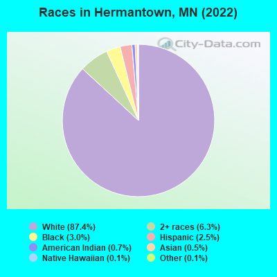
Races in Hermantown detailed stats: ancestries, foreign born residents, place of birth
According to our research of Minnesota and other state lists, there was 1 registered sex offender living in Hermantown, Minnesota as of April 17, 2024.
The ratio of all residents to sex offenders in Hermantown is 9,581 to 1.
The ratio of registered sex offenders to all residents in this city is lower than the state average.
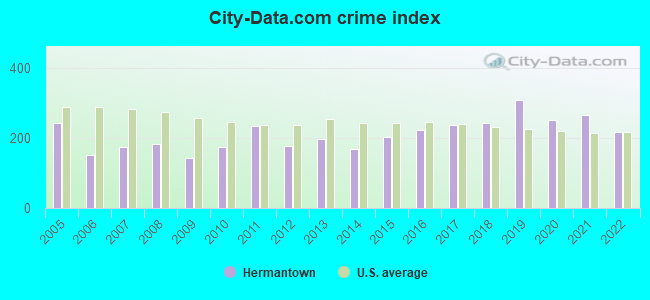
Type |
2009 |
2010 |
2011 |
2012 |
2013 |
2014 |
2015 |
2016 |
2017 |
2018 |
2019 |
2020 |
2021 |
2022 |
|---|---|---|---|---|---|---|---|---|---|---|---|---|---|---|
| Murders (per 100,000) | 0 (0.0) | 0 (0.0) | 0 (0.0) | 0 (0.0) | 0 (0.0) | 0 (0.0) | 0 (0.0) | 0 (0.0) | 0 (0.0) | 0 (0.0) | 0 (0.0) | 0 (0.0) | 0 (0.0) | 0 (0.0) |
| Rapes (per 100,000) | 1 (10.5) | 2 (21.2) | 6 (63.2) | 2 (21.1) | 2 (20.7) | 3 (31.1) | 4 (40.9) | 2 (20.5) | 3 (31.7) | 4 (42.0) | 4 (40.9) | 3 (31.1) | 0 (0.0) | 2 (19.6) |
| Robberies (per 100,000) | 1 (10.5) | 1 (10.6) | 1 (10.5) | 0 (0.0) | 0 (0.0) | 4 (41.5) | 0 (0.0) | 2 (20.5) | 1 (10.6) | 2 (21.0) | 0 (0.0) | 0 (0.0) | 0 (0.0) | 0 (0.0) |
| Assaults (per 100,000) | 2 (21.0) | 6 (63.7) | 10 (105.4) | 1 (10.6) | 2 (20.7) | 3 (31.1) | 1 (10.2) | 4 (41.0) | 7 (74.0) | 4 (42.0) | 5 (51.2) | 9 (93.2) | 11 (115.6) | 17 (166.4) |
| Burglaries (per 100,000) | 25 (262.7) | 33 (350.5) | 56 (590.3) | 46 (485.4) | 56 (579.7) | 28 (290.2) | 42 (429.8) | 40 (409.8) | 49 (518.2) | 47 (493.4) | 25 (255.9) | 38 (393.3) | 33 (346.9) | 40 (391.5) |
| Thefts (per 100,000) | 238 (2,501) | 250 (2,656) | 245 (2,582) | 281 (2,965) | 302 (3,126) | 231 (2,394) | 320 (3,275) | 372 (3,811) | 351 (3,712) | 350 (3,675) | 581 (5,947) | 407 (4,213) | 478 (5,025) | 342 (3,347) |
| Auto thefts (per 100,000) | 12 (126.1) | 11 (116.8) | 17 (179.2) | 5 (52.8) | 14 (144.9) | 11 (114.0) | 9 (92.1) | 13 (133.2) | 12 (126.9) | 15 (157.5) | 12 (122.8) | 13 (134.6) | 20 (210.3) | 9 (88.1) |
| Arson (per 100,000) | 0 (0.0) | 1 (10.6) | 0 (0.0) | 0 (0.0) | 2 (20.7) | 0 (0.0) | 0 (0.0) | 0 (0.0) | 1 (10.6) | 0 (0.0) | 1 (10.2) | 0 (0.0) | 0 (0.0) | 0 (0.0) |
| City-Data.com crime index | 144.3 | 173.0 | 233.8 | 175.8 | 197.9 | 168.7 | 203.2 | 222.5 | 238.3 | 242.4 | 308.6 | 250.3 | 265.2 | 217.3 |
The City-Data.com crime index weighs serious crimes and violent crimes more heavily. Higher means more crime, U.S. average is 246.1. It adjusts for the number of visitors and daily workers commuting into cities.
Crime rate in Hermantown detailed stats: murders, rapes, robberies, assaults, burglaries, thefts, arson
Full-time law enforcement employees in 2021, including police officers: 19 (16 officers - 13 male; 3 female).
| Officers per 1,000 residents here: | 1.68 |
| Minnesota average: | 1.76 |
 Recent articles from our blog. Our writers, many of them Ph.D. graduates or candidates, create easy-to-read articles on a wide variety of topics.

 | Duluth Construction Updates (207 replies) |
| Submerged in Mystery, (12 replies) |
| Why has Duluth become so expensive? (18 replies) |
| Hermantown schools vs Homecroft elem./ Ordean/East schools? (2 replies) |
| Duluth and surrounding cities - input requested (8 replies) |
| Relocation to MN help (6 replies) |
Latest news from Hermantown, MN collected exclusively by city-data.com from local newspapers, TV, and radio stations
Ancestries: German (22.9%), European (10.8%), Norwegian (9.9%), American (6.6%), Swedish (6.5%), Italian (5.6%).
Current Local Time: CST time zone
Elevation: 1365 feet
Land area: 34.3 square miles.
Population density: 295 people per square mile (very low).
183 residents are foreign born
| This city: | 1.8% |
| Minnesota: | 8.5% |
Median real estate property taxes paid for housing units with mortgages in 2022: $5,003 (1.2%)
Median real estate property taxes paid for housing units with no mortgage in 2022: $2,853 (1.1%)
Nearest city with pop. 50,000+: Duluth, MN  (5.2 miles , pop. 86,918).
Nearest city with pop. 200,000+: St. Paul, MN (134.8 miles , pop. 287,151).
Nearest city with pop. 1,000,000+: Chicago, IL (410.0 miles , pop. 2,896,016).
Nearest cities:
), ), ), ), Latitude: 46.80 N, Longitude: 92.22 W
Daytime population change due to commuting: +1,251 (+12.4%)
Workers who live and work in this city: 1,123 (22.9%)

Hermantown, Minnesota accommodation & food services, waste management - Economy and Business Data
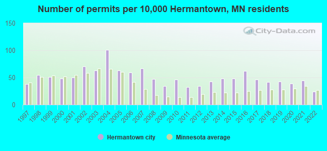
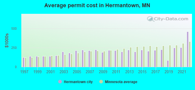
Single-family new house construction building permits:
- 2022: 18 buildings, average cost: $460,400
- 2021: 33 buildings, average cost: $253,300
- 2020: 29 buildings, average cost: $248,600
- 2019: 32 buildings, average cost: $86,800
- 2018: 31 buildings, average cost: $227,200
- 2017: 34 buildings, average cost: $219,900
- 2016: 46 buildings, average cost: $205,500
- 2015: 36 buildings, average cost: $222,300
- 2014: 36 buildings, average cost: $198,400
- 2013: 32 buildings, average cost: $221,400
- 2012: 25 buildings, average cost: $199,800
- 2011: 24 buildings, average cost: $214,500
- 2010: 34 buildings, average cost: $219,700
- 2009: 25 buildings, average cost: $192,100
- 2008: 35 buildings, average cost: $227,900
- 2007: 50 buildings, average cost: $213,500
- 2006: 44 buildings, average cost: $223,600
- 2005: 47 buildings, average cost: $216,000
- 2004: 75 buildings, average cost: $185,300
- 2003: 47 buildings, average cost: $200,400
- 2002: 52 buildings, average cost: $146,700
- 2001: 37 buildings, average cost: $140,200
- 2000: 36 buildings, average cost: $140,300
- 1999: 38 buildings, average cost: $139,900
- 1998: 41 buildings, average cost: $141,200
- 1997: 28 buildings, average cost: $125,800
| Here: | 2.9% |
| Minnesota: | 2.6% |
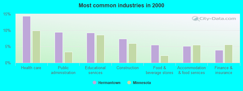
- Health care (14.4%)
- Public administration (9.4%)
- Educational services (9.2%)
- Construction (7.3%)
- Food & beverage stores (5.5%)
- Accommodation & food services (5.1%)
- Finance & insurance (3.9%)
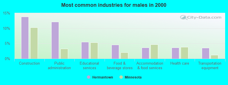
- Construction (13.7%)
- Public administration (12.2%)
- Educational services (5.5%)
- Food & beverage stores (4.5%)
- Accommodation & food services (3.7%)
- Health care (3.6%)
- Transportation equipment (3.5%)
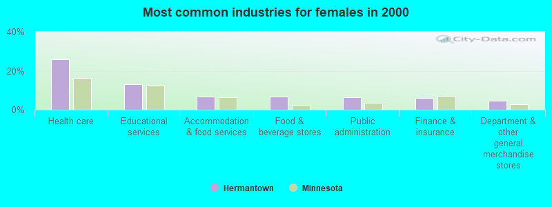
- Health care (25.9%)
- Educational services (13.2%)
- Accommodation & food services (6.7%)
- Food & beverage stores (6.6%)
- Public administration (6.4%)
- Finance & insurance (5.9%)
- Department & other general merchandise stores (4.7%)

- Registered nurses (4.8%)
- Other sales and related occupations, including supervisors (4.4%)
- Other office and administrative support workers, including supervisors (4.1%)
- Retail sales workers, except cashiers (3.7%)
- Material recording, scheduling, dispatching, and distributing workers (3.6%)
- Other management occupations, except farmers and farm managers (3.3%)
- Health technologists and technicians (3.2%)
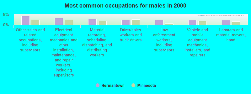
- Other sales and related occupations, including supervisors (6.7%)
- Electrical equipment mechanics and other installation, maintenance, and repair workers, including supervisors (5.3%)
- Material recording, scheduling, dispatching, and distributing workers (4.6%)
- Driver/sales workers and truck drivers (4.0%)
- Law enforcement workers, including supervisors (3.8%)
- Vehicle and mobile equipment mechanics, installers, and repairers (3.6%)
- Laborers and material movers, hand (3.6%)

- Registered nurses (9.9%)
- Other office and administrative support workers, including supervisors (6.6%)
- Retail sales workers, except cashiers (5.3%)
- Health technologists and technicians (5.0%)
- Secretaries and administrative assistants (4.9%)
- Cashiers (4.3%)
- Other management occupations, except farmers and farm managers (3.4%)
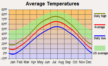
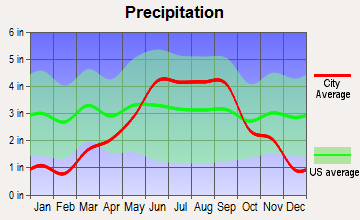
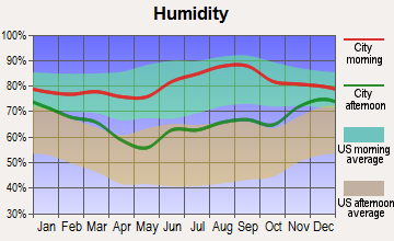
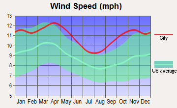
Average climate in Hermantown, Minnesota
Based on data reported by over 4,000 weather stations
|
|

(lower is better)
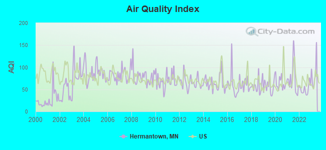
Air Quality Index (AQI) level in 2022 was 50.4. This is significantly better than average.
| City: | 50.4 |
| U.S.: | 72.6 |
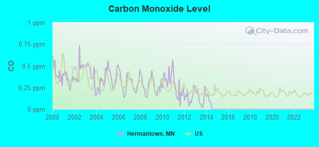
Carbon Monoxide (CO) [ppm] level in 2013 was 0.135. This is significantly better than average. Closest monitor was 5.2 miles away from the city center.
| City: | 0.135 |
| U.S.: | 0.251 |
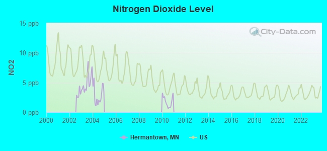
Nitrogen Dioxide (NO2) [ppb] level in 2010 was 1.80. This is significantly better than average. Closest monitor was 2.7 miles away from the city center.
| City: | 1.80 |
| U.S.: | 5.11 |
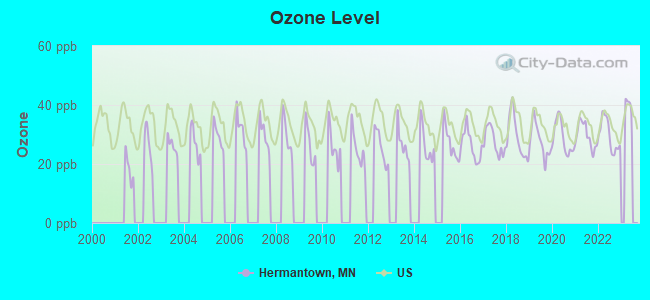
Ozone [ppb] level in 2022 was 29.7. This is about average. Closest monitor was 5.8 miles away from the city center.
| City: | 29.7 |
| U.S.: | 33.3 |
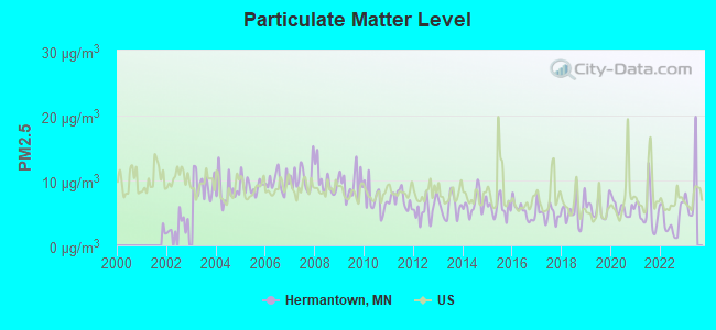
Particulate Matter (PM2.5) [µg/m3] level in 2022 was 3.75. This is significantly better than average. Closest monitor was 4.8 miles away from the city center.
| City: | 3.75 |
| U.S.: | 8.11 |
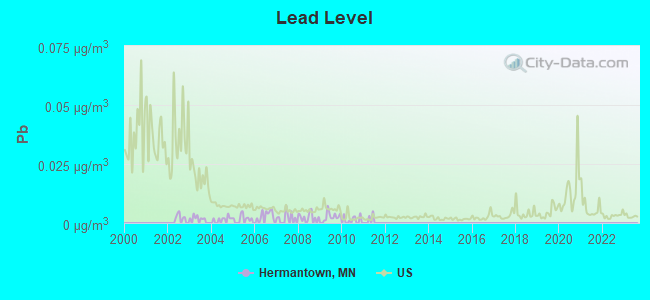
Lead (Pb) [µg/m3] level in 2010 was 0.00117. This is significantly better than average. Closest monitor was 2.7 miles away from the city center.
| City: | 0.00117 |
| U.S.: | 0.00931 |
Tornado activity:
Hermantown-area historical tornado activity is significantly below Minnesota state average. It is 73% smaller than the overall U.S. average.
On 6/11/1966, a category F4 (max. wind speeds 207-260 mph) tornado 28.8 miles away from the Hermantown city center caused between $50,000 and $500,000 in damages.
On 8/6/1969, a category F3 (max. wind speeds 158-206 mph) tornado 17.5 miles away from the city center killed 2 people and injured 3 people and caused between $50,000 and $500,000 in damages.
Earthquake activity:
Hermantown-area historical earthquake activity is significantly above Minnesota state average. It is 64% smaller than the overall U.S. average.On 7/9/1975 at 14:54:15, a magnitude 4.6 (4.6 MB, Class: Light, Intensity: IV - V) earthquake occurred 198.7 miles away from the city center
On 2/7/2020 at 18:30:28, a magnitude 3.3 (3.3 ML, Class: Light, Intensity: II - III) earthquake occurred 52.5 miles away from Hermantown center
On 1/9/2020 at 18:16:48, a magnitude 3.3 (3.3 MB) earthquake occurred 55.9 miles away from the city center
On 6/5/1993 at 01:24:53, a magnitude 4.1 (4.1 LG, Depth: 6.2 mi) earthquake occurred 209.7 miles away from the city center
On 4/8/2020 at 17:14:33, a magnitude 3.3 (3.3 ML) earthquake occurred 56.6 miles away from Hermantown center
On 4/24/2020 at 17:23:43, a magnitude 3.2 (3.2 ML) earthquake occurred 53.4 miles away from the city center
Magnitude types: regional Lg-wave magnitude (LG), body-wave magnitude (MB), local magnitude (ML)
Natural disasters:
The number of natural disasters in St. Louis County (3) is a lot smaller than the US average (15).Causes of natural disasters: Floods: 2, Storms: 2, Tornado: 1, Wind: 1, Other: 1 (Note: some incidents may be assigned to more than one category).
Hospitals and medical centers near Hermantown:
- VIEWCREST HEALTH CENTER (Nursing Home, about 4 miles away; DULUTH, MN)
- MSOCS DULUTH ICFMR GROUP HOME (Hospital, about 4 miles away; DULUTH, MN)
- HEARTHSTONE HOME CARE LLC (Home Health Center, about 5 miles away; DULUTH, MN)
- CHRIS JENSEN HEALTH AND REHABILITATION CENTER (Nursing Home, about 5 miles away; DULUTH, MN)
- ST LOUIS CTY MEDICAL CTR (Nursing Home, about 5 miles away; DULUTH, MN)
- NURSES THAT CARE INC (Home Health Center, about 5 miles away; DULUTH, MN)
- FRESENIUS MEDICAL CARE - SPIRIT VALLEY (Dialysis Facility, about 6 miles away; DULUTH, MN)
Colleges/universities with over 2000 students nearest to Hermantown:
- Lake Superior College (about 4 miles; Duluth, MN; Full-time enrollment: 3,768)
- The College of Saint Scholastica (about 6 miles; Duluth, MN; FT enrollment: 3,762)
- University of Minnesota-Duluth (about 7 miles; Duluth, MN; FT enrollment: 10,612)
- University of Wisconsin-Superior (about 9 miles; Superior, WI; FT enrollment: 2,302)
- Wisconsin Indianhead Technical College (about 75 miles; Shell Lake, WI; FT enrollment: 2,414)
- Central Lakes College-Brainerd (about 100 miles; Brainerd, MN; FT enrollment: 3,371)
- Anoka-Ramsey Community College (about 126 miles; Coon Rapids, MN; FT enrollment: 5,918)
Public high schools in Hermantown:
- HERMANTOWN SENIOR HIGH (Location: 4335 HAWK CIRCLE DR, Grades: 9-12)
- HERMANTOWN ALTERNATIVE LEARNING PRG (Location: 4335 HAWK CIRCLE DR, Grades: 9-12)
Public elementary/middle schools in Hermantown:
- HERMANTOWN ELEMENTARY (Location: 5365 W ARROWHEAD, Grades: KG-3)
- HERMANTOWN MIDDLE (Location: 4289 UGSTAD RD, Grades: 4-8)
Points of interest:
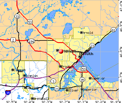
Notable locations in Hermantown: Hermantown Volunteer Fire Department Station 1 (A), Hermantown Police Department (B), Hermantown Volunteer Fire Department Station 2 (C), Hermantown Volunteer Fire Department Station 3 (D). Display/hide their locations on the map
Churches in Hermantown include: Hermantown Community Church (A), Peace in Christ Lutheran Church (B), Trinity Episcopal Church (C), Faith Baptist Church (D), Grace Lutheran Church (E), Salem Church (F), Gethsemane Church (G). Display/hide their locations on the map
Cemeteries: Union Cemetery (1), Sunrise Memorial Cemetery (2), Jewish Cemetery (3), Hermantown Cemetery (4), Bethany Cemetery (5). Display/hide their locations on the map
Lake: Mogie Lake (A). Display/hide its location on the map
Streams, rivers, and creeks: Rocky Run (A). Display/hide its location on the map
Tourist attraction: Commemorative Air Force (Museums; 4931 Airport Road) (1). Display/hide its approximate location on the map
Hotels: Edgetown Motel (5150 Miller Trunk Highway) (1), Airliner Motel (5002 Miller Trunk Highway) (2), Skyline Court Motel (4880 Miller Trunk Highway) (3). Display/hide their approximate locations on the map
| This city: | 2.5 people |
| Minnesota: | 2.5 people |
| This city: | 70.1% |
| Whole state: | 64.6% |
| This city: | 5.8% |
| Whole state: | 6.9% |
Likely homosexual households (counted as self-reported same-sex unmarried-partner households)
- Lesbian couples: 0.2% of all households
- Gay men: 0.2% of all households
People in group quarters in Hermantown in 2010:
- 772 people in federal prisons
- 61 people in group homes intended for adults
- 25 people in nursing facilities/skilled-nursing facilities
- 8 people in group homes for juveniles (non-correctional)
- 3 people in emergency and transitional shelters (with sleeping facilities) for people experiencing homelessness
People in group quarters in Hermantown in 2000:
- 128 people in other noninstitutional group quarters
- 30 people in nursing homes
- 5 people in other group homes
Banks with branches in Hermantown (2011 data):
- North Shore Bank of Commerce: Hermantown Branch at 4810 Miller Trunk Highway, branch established on 1963/06/17. Info updated 2006/11/03: Bank assets: $226.4 mil, Deposits: $210.3 mil, headquarters in Duluth, MN, positive income, Commercial Lending Specialization, 8 total offices, Holding Company: North Shore Financial Corporation
- Republic Bank, Inc.: Hermantown Branch at 5094 Miller Trunk Highway, branch established on 2008/01/15. Info updated 2006/11/03: Bank assets: $314.8 mil, Deposits: $266.4 mil, headquarters in Duluth, MN, positive income, Commercial Lending Specialization, 7 total offices, Holding Company: Republic Bancshares, Inc.
- National Bank of Commerce: Hermantown Branch at 4105 Richard Avenue, branch established on 2004/12/01. Info updated 2008/12/02: Bank assets: $539.6 mil, Deposits: $449.5 mil, headquarters in Superior, WI, positive income, Commercial Lending Specialization, 7 total offices, Holding Company: Natcom Bancshares,inc.
For population 15 years and over in Hermantown:
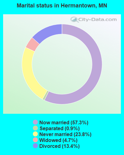
- Never married: 23.8%
- Now married: 57.3%
- Separated: 0.9%
- Widowed: 4.7%
- Divorced: 13.4%
For population 25 years and over in Hermantown:
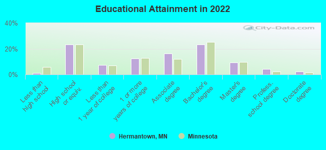
- High school or higher: 98.8%
- Bachelor's degree or higher: 38.9%
- Graduate or professional degree: 15.3%
- Unemployed: 5.2%
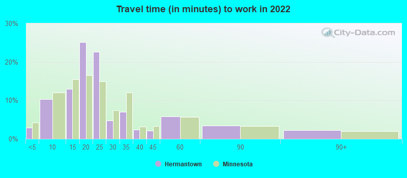
- Mean travel time to work (commute): 16.4 minutes
| Here: | 9.4 |
| Minnesota average: | 10.9 |

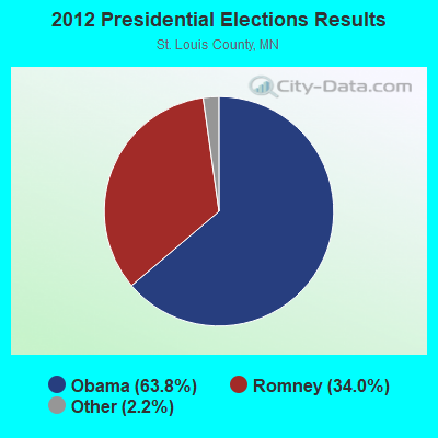


Graphs represent county-level data. Detailed 2008 Election Results
Religion statistics for Hermantown, MN (based on St. Louis County data)
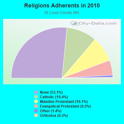
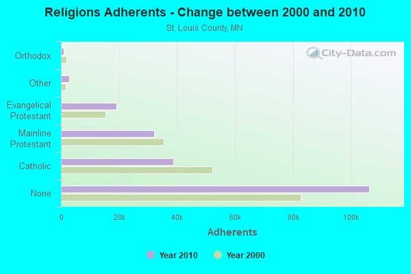
| Religion | Adherents | Congregations |
|---|---|---|
| Catholic | 38,757 | 36 |
| Mainline Protestant | 32,143 | 91 |
| Evangelical Protestant | 19,017 | 118 |
| Other | 2,760 | 20 |
| Orthodox | 976 | 6 |
| Black Protestant | 177 | 1 |
| None | 106,396 | - |
Food Environment Statistics:
| St. Louis County: | 1.99 / 10,000 pop. |
| Minnesota: | 1.83 / 10,000 pop. |
| Here: | 0.10 / 10,000 pop. |
| State: | 0.13 / 10,000 pop. |
| St. Louis County: | 0.10 / 10,000 pop. |
| Minnesota: | 0.49 / 10,000 pop. |
| St. Louis County: | 5.40 / 10,000 pop. |
| State: | 3.90 / 10,000 pop. |
| St. Louis County: | 8.96 / 10,000 pop. |
| State: | 6.98 / 10,000 pop. |
| Here: | 6.7% |
| Minnesota: | 6.5% |
| St. Louis County: | 25.3% |
| State: | 25.9% |
| St. Louis County: | 11.3% |
| State: | 13.0% |
Health and Nutrition:
| Hermantown: | 56.1% |
| Minnesota: | 50.6% |
| This city: | 55.7% |
| State: | 48.4% |
| This city: | 27.7 |
| Minnesota: | 28.5 |
| Hermantown: | 20.1% |
| Minnesota: | 21.0% |
| Here: | 7.8% |
| Minnesota: | 9.8% |
| Hermantown: | 7.0 |
| Minnesota: | 6.8 |
| Hermantown: | 32.5% |
| Minnesota: | 33.5% |
| Here: | 63.0% |
| Minnesota: | 57.7% |
| This city: | 80.6% |
| Minnesota: | 79.3% |
More about Health and Nutrition of Hermantown, MN Residents
| Local government employment and payroll (March 2022) | |||||
| Function | Full-time employees | Monthly full-time payroll | Average yearly full-time wage | Part-time employees | Monthly part-time payroll |
|---|---|---|---|---|---|
| Police Protection - Officers | 16 | $113,473 | $85,105 | 0 | $0 |
| Financial Administration | 4 | $24,768 | $74,304 | 0 | $0 |
| Other Government Administration | 4 | $28,680 | $86,040 | 6 | $3,925 |
| Police - Other | 3 | $14,164 | $56,656 | 0 | $0 |
| Streets and Highways | 3 | $19,686 | $78,744 | 0 | $0 |
| Other and Unallocable | 2 | $12,848 | $77,088 | 1 | $811 |
| Sewerage | 2 | $10,823 | $64,938 | 0 | $0 |
| Water Supply | 2 | $12,541 | $75,246 | 0 | $0 |
| Parks and Recreation | 1 | $5,141 | $61,692 | 0 | $0 |
| Housing and Community Development (Local) | 1 | $9,172 | $110,064 | 0 | $0 |
| Totals for Government | 38 | $251,298 | $79,357 | 7 | $4,736 |
Hermantown government finances - Expenditure in 2017 (per resident):
- Construction - Regular Highways: $2,185,000 ($215.78)
- Current Operations - Police Protection: $2,122,000 ($209.56)
Sewerage: $1,348,000 ($133.12)
Water Utilities: $1,320,000 ($130.36)
Regular Highways: $798,000 ($78.81)
General - Other: $607,000 ($59.94)
Local Fire Protection: $554,000 ($54.71)
Financial Administration: $482,000 ($47.60)
Protective Inspection and Regulation - Other: $135,000 ($13.33)
Parks and Recreation: $113,000 ($11.16)
Central Staff Services: $54,000 ($5.33)
Miscellaneous Commercial Activities - Other: $2,000 ($0.20)
- General - Interest on Debt: $840,000 ($82.95)
- Other Capital Outlay - Regular Highways: $636,000 ($62.81)
General - Other: $279,000 ($27.55)
Solid Waste Management: $75,000 ($7.41)
Police Protection: $63,000 ($6.22)
Sewerage: $55,000 ($5.43)
Parks and Recreation: $45,000 ($4.44)
Water Utilities: $25,000 ($2.47)
Hermantown government finances - Revenue in 2017 (per resident):
- Charges - Sewerage: $1,483,000 ($146.45)
Other: $148,000 ($14.62)
Regular Highways: $136,000 ($13.43)
Parks and Recreation: $10,000 ($0.99)
- Federal Intergovernmental - Other: $2,000 ($0.20)
- Miscellaneous - Special Assessments: $727,000 ($71.80)
Interest Earnings: $94,000 ($9.28)
Fines and Forfeits: $64,000 ($6.32)
General Revenue - Other: $25,000 ($2.47)
- Revenue - Water Utilities: $1,479,000 ($146.06)
- State Intergovernmental - Other: $2,469,000 ($243.83)
General Local Government Support: $164,000 ($16.20)
- Tax - Property: $4,177,000 ($412.50)
General Sales and Gross Receipts: $2,984,000 ($294.69)
Other License: $315,000 ($31.11)
Public Utilities Sales: $38,000 ($3.75)
Hermantown government finances - Debt in 2017 (per resident):
- Long Term Debt - Outstanding Unspecified Public Purpose: $27,965,000 ($2761.70)
Beginning Outstanding - Unspecified Public Purpose: $22,911,000 ($2262.59)
Issue, Unspecified Public Purpose: $8,340,000 ($823.62)
Retired Unspecified Public Purpose: $3,286,000 ($324.51)
Hermantown government finances - Cash and Securities in 2017 (per resident):
- Bond Funds - Cash and Securities: $1,691,000 ($167.00)
- Other Funds - Cash and Securities: $5,587,000 ($551.75)
- Sinking Funds - Cash and Securities: $1,934,000 ($190.99)
| Businesses in Hermantown, MN | ||||
| Name | Count | Name | Count | |
|---|---|---|---|---|
| Chevrolet | 1 | Outback Steakhouse | 1 | |
| Dairy Queen | 1 | Sam's Club | 1 | |
| Decora Cabinetry | 2 | Slumberland | 1 | |
| Hyundai | 1 | Subaru | 1 | |
| Lane Furniture | 1 | Subway | 1 | |
| MasterBrand Cabinets | 3 | U-Haul | 2 | |
| McDonald's | 1 | Volkswagen | 1 | |
| Menards | 1 | Walmart | 1 | |
| Outback | 1 | |||
Strongest AM radio stations in Hermantown:
- WEBC (560 AM; 50 kW; DULUTH, MN)
- KDAL (610 AM; 5 kW; DULUTH, MN; Owner: MIDWEST COMMUNICATIONS, INC.)
- WDSM (710 AM; 10 kW; SUPERIOR, WI; Owner: MIDWEST COMMUNICATIONS, INC.)
- WWJC (850 AM; daytime; 10 kW; DULUTH, MN; Owner: WWJC, INC.)
- KQDS (1490 AM; 1 kW; DULUTH, MN; Owner: RED ROCK RADIO CORP.)
- WGEE (970 AM; 1 kW; SUPERIOR, WI; Owner: MIDWEST COMMUNICATIONS, INC.)
- WKLK (1230 AM; 1 kW; CLOQUET, MN; Owner: QB BROADCASTING, LTD.)
- WNMT (650 AM; 10 kW; NASHWAUK, MN; Owner: MIDWEST RADIO NETWORK, L.L.C.)
- WCCO (830 AM; 50 kW; MINNEAPOLIS, MN; Owner: INFINITY MEDIA CORPORATION)
- WCTS (1030 AM; 50 kW; MAPLEWOOD, MN; Owner: CNTL. BAPT. THEO/AL SEMI MINNEAPOLIS)
- KSTP (1500 AM; 50 kW; ST. PAUL, MN; Owner: KSTP-AM, LLC (DELAWARE))
- KFAN (1130 AM; 50 kW; MINNEAPOLIS, MN; Owner: AMFM RADIO LICENSES, L.L.C.)
- KPRM (870 AM; 25 kW; PARK RAPIDS, MN; Owner: DE LA HUNT BROADCASTING CORP.)
Strongest FM radio stations in Hermantown:
- KBMX (107.7 FM; PROCTOR, MN; Owner: REGENT BROADCASTING OF DULUTH, INC.)
- WWAX (92.1 FM; HERMANTOWN, MN; Owner: RED ROCK RADIO CORP.)
- KUMD-FM (103.3 FM; DULUTH, MN; Owner: REGENTS OF UNIVERSITY OF MINNESOTA)
- KQDS-FM (94.9 FM; DULUTH, MN; Owner: RED ROCK RADIO CORP.)
- KLDJ (101.7 FM; DULUTH, MN; Owner: REGENT BROADCASTING OF DULUTH, INC.)
- WSCN (100.5 FM; CLOQUET, MN; Owner: MINNESOTA PUBLIC RADIO)
- KDAL-FM (95.7 FM; DULUTH, MN; Owner: MIDWEST COMMUNICATIONS, INC.)
- KDNI (90.5 FM; DULUTH, MN; Owner: NORTHWESTERN COLLEGE)
- KKCB (105.1 FM; DULUTH, MN; Owner: REGENT BROADCASTING OF DULUTH, INC.)
- KUWS (91.3 FM; SUPERIOR, WI; Owner: BD. OF REGENTS, UNIV. OF WISC. SYS.)
- KRBR-FM (102.5 FM; SUPERIOR, WI; Owner: MIDWEST COMMUNICATIONS, INC.)
- WSCD-FM (92.9 FM; DULUTH, MN; Owner: MINNESOTA PUBLIC RADIO)
- KTCO (98.9 FM; DULUTH, MN; Owner: MIDWEST COMMUNICATIONS, INC.)
- WNCB (89.5 FM; DULUTH, MN; Owner: REFUGE MEDIA GROUP)
- KDNW (97.3 FM; DULUTH, MN; Owner: NORTHWESTERN COLLEGE)
- W203AL (88.5 FM; DULUTH, MN; Owner: FAMILY STATIONS, INC.)
- WKLK-FM (96.5 FM; CLOQUET, MN; Owner: QB BROADCASTING, LTD.)
- KZIO (104.3 FM; TWO HARBORS, MN; Owner: RED ROCK RADIO CORP.)
- K292EZ (106.3 FM; DULUTH, MN; Owner: RED ROCK RADIO CORP.)
TV broadcast stations around Hermantown:
- WDIO-TV (Channel 10; DULUTH, MN; Owner: WDIO-TV, LLC)
- KDLH (Channel 3; DULUTH, MN; Owner: CHELSEY BROADCASTING COMPANY OF DULUTH, LLC)
- WDSE-TV (Channel 8; DULUTH, MN; Owner: DULUTH-SUPERIOR AREA EDUCATIONAL TV CORPORATION)
- KQDS-TV (Channel 21; DULUTH, MN; Owner: KQDS ACQUISITION CORP.)
- KBJR-TV (Channel 6; SUPERIOR, WI; Owner: KBJR LICENSE, INC.)
- K58CM (Channel 58; DULUTH, MN; Owner: TRINITY BROADCASTING NETWORK)
- KDUL-LP (Channel 60; DULUTH, MN; Owner: DULUTH TV PARTNERS, GP)
- K38DS (Channel 38; DULUTH, MN; Owner: STEVEN R. ZUKERBERG)
- K62EP (Channel 62; DULUTH, MN; Owner: DAN BLECHMAN)
- K64EF (Channel 64; DULUTH, MN; Owner: STEVEN R. ZUKERBERG)
- K68EA (Channel 68; DULUTH, MN; Owner: MS COMMUNICATIONS, LLC)
- KWMN-LP (Channel 56; DULUTH, MN; Owner: DULUTH DATACASTING PARTNERS, G.P.)
- K15DU (Channel 15; DULUTH, MN; Owner: DAN BLECHMAN)
- K66EO (Channel 66; DULUTH, MN; Owner: HAROLD AND/ OR SUE KROGMAN)
- National Bridge Inventory (NBI) Statistics
- 18Number of bridges
- 164ft / 49.9mTotal length
- $1,162,000,000Total costs
- 64,173Total average daily traffic
- 3,091Total average daily truck traffic
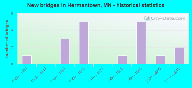
- New bridges - historical statistics
- 11930-1939
- 31950-1959
- 51960-1969
- 11980-1989
- 51990-1999
- 12000-2009
- 22010-2019
FCC Registered Antenna Towers:
42 (See the full list of FCC Registered Antenna Towers in Hermantown)FCC Registered Broadcast Land Mobile Towers:
6- 4301 Menard Drive (Lat: 46.822500 Lon: -92.182778), Call Sign: WQBL741,
Assigned Frequencies: 30.8400 MHz, 154.540 MHz, 33.4000 MHz, 33.1600 MHz, 31.2400 MHz, 468.487 MHz, 468.762 MHz, 468.837 MHz, 469.462 MHz, 469.637 MHz... (+22 more), Grant Date: 11/02/2004, Expiration Date: 11/02/2014, Cancellation Date: 01/03/2015, Certifier: Beth Cotner, Registrant: Dolfen Consulting Group, 95 Willow Lane, Bristol, IL 60512-9711, Phone: (630) 553-5886, Fax: (630) 566-1755, Email:
- 4275 Haines Road (Lat: 46.815833 Lon: -92.174722), Call Sign: WQCM369,
Assigned Frequencies: 467.762 MHz, 457.512 MHz, 467.487 MHz, 462.187 MHz, 462.462 MHz, Grant Date: 04/06/2005, Expiration Date: 04/06/2015, Cancellation Date: 06/06/2015, Certifier: Brian Sword, Registrant: Advanced Wireless Communications, 20809 Kensington Blvd., Lakeville, MN 55044, Phone: (952) 469-5400, Email:
- Lat: 46.812278 Lon: -92.199917, Call Sign: WQJZ501,
Assigned Frequencies: 467.287 MHz, Grant Date: 02/05/2019, Expiration Date: 02/24/2029, Certifier: Glen Leibel, Registrant: Cara Enterprises Inc, Las Vegas, NV 89140-0124, Phone: (702) 838-9728, Fax: (702) 363-4607, Email:
- Lat: 46.812278 Lon: -92.199917, Call Sign: WQLU822,
Assigned Frequencies: 461.912 MHz, Grant Date: 02/21/2020, Expiration Date: 04/29/2030, Certifier: John Buesgens, Registrant: Business Radio Licensing, 30251 Golden Lantern, Suite E # 501, Laguna Niguel, CA 92677, Phone: (949) 348-8510, Fax: (949) 348-8514, Email:
- End Of Oak Ridge Dr, East Of Stebner Rd (Lat: 46.796250 Lon: -92.186750), Type: Bant, Structure height: 5 m, Overall height: 6.1 m, Call Sign: WQND595,
Assigned Frequencies: 461.912 MHz, Grant Date: 12/09/2020, Expiration Date: 12/30/2030, Certifier: John Steltr, Registrant: Business Radio Licensing, 30251 Golden Lantern, Suite E # 501, Laguna Niguel, CA 92677, Phone: (949) 348-8510, Fax: (949) 348-8514, Email:
- Thompson& Lavaque Rd (Lat: 46.771444 Lon: -92.211194), Type: Bant, Structure height: 14 m, Overall height: 15.2 m, Call Sign: WQOU681,
Assigned Frequencies: 461.912 MHz, Grant Date: 11/16/2021, Expiration Date: 02/03/2032, Certifier: Glen Leibel, Registrant: Duluth Superior Communications, 711 Hammond Ave., Superior, WI 54880, Phone: (715) 392-2911, Fax: (715) 392-2995, Email:
FCC Registered Microwave Towers:
8 (See the full list of FCC Registered Microwave Towers in this town)FCC Registered Paging Towers:
3 (See the full list of FCC Registered Paging Towers)FCC Registered Amateur Radio Licenses:
34 (See the full list of FCC Registered Amateur Radio Licenses in Hermantown)FAA Registered Aircraft:
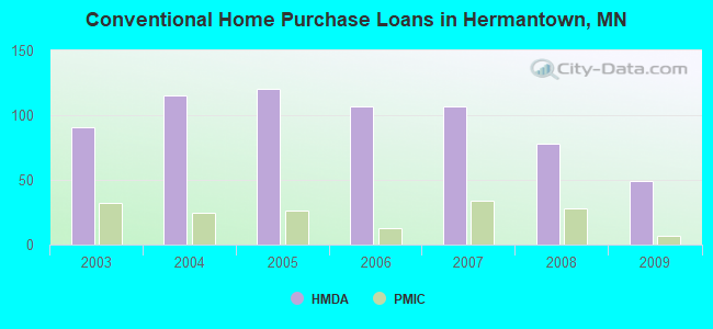
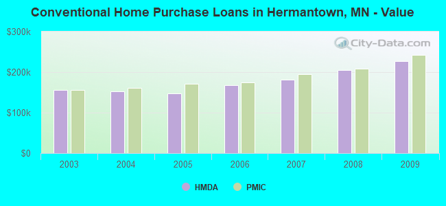
20 (See the full list of FAA Registered Aircraft in Hermantown)| Home Mortgage Disclosure Act Aggregated Statistics For Year 2009 (Based on 2 partial tracts) | ||||||||||||||
| A) FHA, FSA/RHS & VA Home Purchase Loans | B) Conventional Home Purchase Loans | C) Refinancings | D) Home Improvement Loans | E) Loans on Dwellings For 5+ Families | F) Non-occupant Loans on < 5 Family Dwellings (A B C & D) | G) Loans On Manufactured Home Dwelling (A B C & D) | ||||||||
|---|---|---|---|---|---|---|---|---|---|---|---|---|---|---|
| Number | Average Value | Number | Average Value | Number | Average Value | Number | Average Value | Number | Average Value | Number | Average Value | Number | Average Value | |
| LOANS ORIGINATED | 16 | $173,842 | 49 | $226,550 | 269 | $181,501 | 24 | $51,737 | 3 | $895,487 | 8 | $181,180 | 8 | $115,922 |
| APPLICATIONS APPROVED, NOT ACCEPTED | 1 | $115,220 | 6 | $307,090 | 24 | $167,882 | 1 | $126,520 | 0 | $0 | 1 | $93,100 | 0 | $0 |
| APPLICATIONS DENIED | 1 | $203,000 | 2 | $262,865 | 53 | $180,941 | 2 | $33,185 | 0 | $0 | 3 | $146,703 | 4 | $131,332 |
| APPLICATIONS WITHDRAWN | 1 | $251,530 | 6 | $174,205 | 31 | $203,518 | 1 | $148,660 | 0 | $0 | 1 | $152,200 | 2 | $184,500 |
| FILES CLOSED FOR INCOMPLETENESS | 0 | $0 | 2 | $314,140 | 11 | $164,486 | 2 | $81,220 | 0 | $0 | 0 | $0 | 1 | $82,300 |
Detailed HMDA statistics for the following Tracts: 0003.00 , 0103.00
| Private Mortgage Insurance Companies Aggregated Statistics For Year 2009 (Based on 2 partial tracts) | ||||
| A) Conventional Home Purchase Loans | B) Refinancings | |||
|---|---|---|---|---|
| Number | Average Value | Number | Average Value | |
| LOANS ORIGINATED | 7 | $241,634 | 12 | $238,756 |
| APPLICATIONS APPROVED, NOT ACCEPTED | 1 | $219,460 | 3 | $283,040 |
| APPLICATIONS DENIED | 0 | $0 | 4 | $219,012 |
| APPLICATIONS WITHDRAWN | 0 | $0 | 0 | $0 |
| FILES CLOSED FOR INCOMPLETENESS | 0 | $0 | 0 | $0 |
Detailed PMIC statistics for the following Tracts: 0003.00 , 0103.00
2002 - 2018 National Fire Incident Reporting System (NFIRS) incidents
- Fire incident types reported to NFIRS in Hermantown, MN
- 24543.4%Structure Fires
- 19734.9%Outside Fires
- 10518.6%Mobile Property/Vehicle Fires
- 183.2%Other
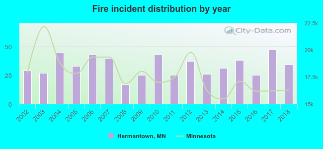 According to the data from the years 2002 - 2018 the average number of fire incidents per year is 33. The highest number of reported fire incidents - 47 took place in 2017, and the least - 17 in 2008. The data has a growing trend.
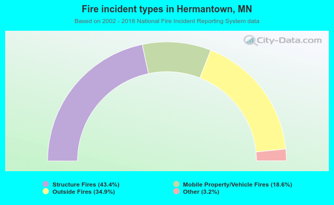 When looking into fire subcategories, the most reports belonged to: Structure Fires (43.4%), and Outside Fires (34.9%).
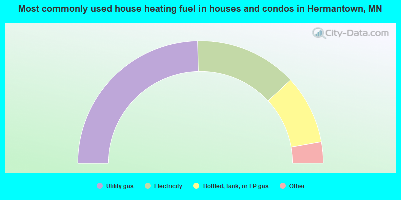
- 49.4%Utility gas
- 26.9%Electricity
- 18.2%Bottled, tank, or LP gas
- 2.8%Wood
- 2.2%Fuel oil, kerosene, etc.
- 0.5%Other fuel
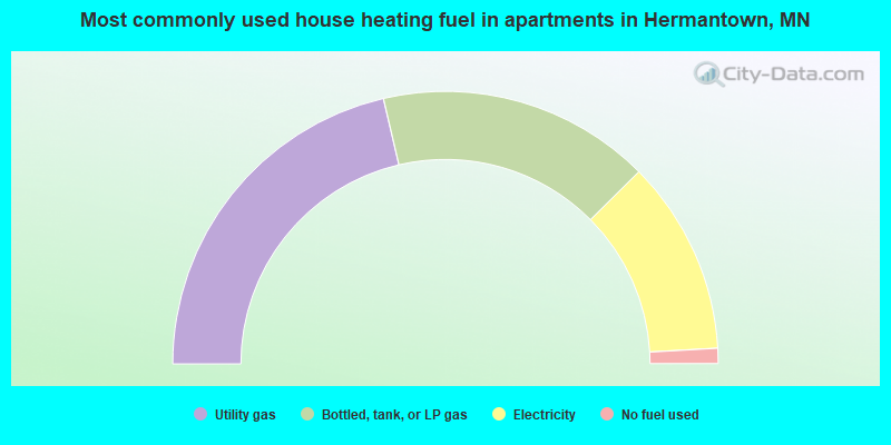
- 42.7%Utility gas
- 32.4%Bottled, tank, or LP gas
- 23.1%Electricity
- 1.8%No fuel used
Hermantown compared to Minnesota state average:
- Unemployed percentage below state average.
- Black race population percentage below state average.
- Hispanic race population percentage below state average.
- Foreign-born population percentage significantly below state average.
- Length of stay since moving in above state average.
- Institutionalized population percentage significantly above state average.

|
|
Total of 46 patent applications in 2008-2024.