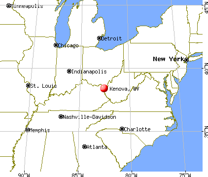
Kenova, West Virginia

Submit your own pictures of this city and show them to the world
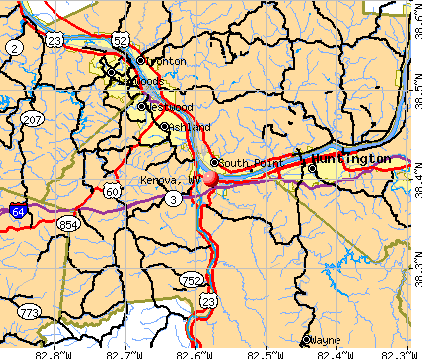
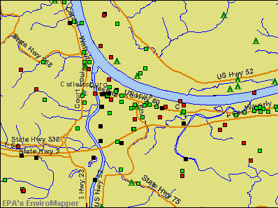
- OSM Map
- General Map
- Google Map
- MSN Map
Population change since 2000: -15.9%
 |
| Males: 1,332 | |
| Females: 1,598 |
| Median resident age: | 50.9 years |
| West Virginia median age: | 42.9 years |
Zip codes: 25530.
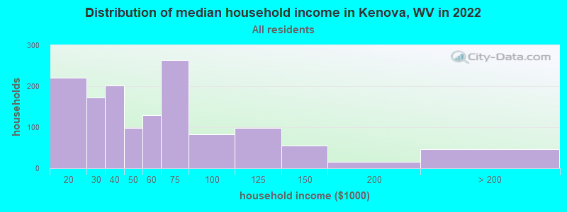
| Kenova: | $49,094 |
| WV: | $54,329 |
Estimated per capita income in 2022: $43,779 (it was $16,485 in 2000)
Kenova city income, earnings, and wages data
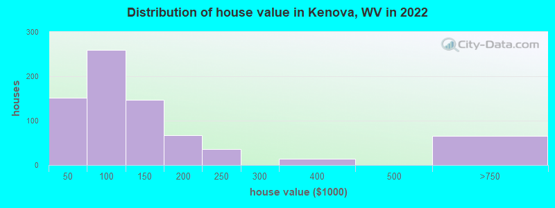
Estimated median house or condo value in 2022: $99,996 (it was $60,700 in 2000)
| Kenova: | $99,996 |
| WV: | $155,100 |
Mean prices in 2022: all housing units: $121,091; detached houses: $143,301; mobile homes: $12,925
Median gross rent in 2022: $769.
(9.0% for White Non-Hispanic residents, 3.5% for Black residents)
Detailed information about poverty and poor residents in Kenova, WV
Compare current foreclosures near Kenova, WV:
| Photo | Address | Area | Beds / Baths | Price | Details |
|---|---|---|---|---|---|

|
#1
Walnut St
Kenova, WV 25530
|
2,063 sq. feet
|
2 baths 4 beds |
$225,000
|
show details |

|
#2
Route 75
Kenova, WV 25530
|
1,580 sq. feet
|
2 baths 3 beds |
$199,900
|
show details |

|
#3
Walnut St
Kenova, WV 25530
|
2,142 sq. feet
|
1 baths 3 beds |
show details | |

|
#4
Oak St
Kenova, WV 25530
|
1,152 sq. feet
|
1 baths 3 beds |
show details | |

|
#5
Maple St
Kenova, WV 25530
|
- sq. feet
|
- baths - beds |
show details | |

|
#6
Hidden Meadows Ln
Kenova, WV 25530
|
- sq. feet
|
- baths - beds |
show details | |

|
#7
Oak St Apt 4
Kenova, WV 25530
|
- sq. feet
|
- baths - beds |
show details | |

|
#8
Jorclay Dr
Kenova, WV 25530
|
- sq. feet
|
- baths - beds |
show details | |

|
#9
Pinto Ln
Kenova, WV 25530
|
- sq. feet
|
- baths - beds |
show details | |

|
#10
Barger Hill Rd
Kenova, WV 25530
|
- sq. feet
|
- baths - beds |
show details |
| Photo | Address | Area | Beds / Baths | Price | Details |
|---|---|---|---|---|---|

|
#11
Jackson Ave
Huntington, WV 25704
|
1,450 sq. feet
|
2 baths 2 beds |
$145,000
|
show details |

|
#12
Twp. Rd 1366
South Point, OH 45680
|
1,144 sq. feet
|
1 baths 2 beds |
$124,900
|
show details |

|
#13
Jefferson Ave
Huntington, WV 25704
|
1,827 sq. feet
|
2 baths 3 beds |
$54,900
|
show details |

|
#14
Township Rd 1007
Chesapeake, OH 45619
|
1,560 sq. feet
|
2 baths 3 beds |
$59,300
|
show details |

|
#15
& 3328 Crane Avenue
Huntington, WV 25705
|
950 sq. feet
|
1 baths 3 beds |
$42,500
|
show details |

|
#16
4th Ave
Huntington, WV 25702
|
1,305 sq. feet
|
2 baths 3 beds |
$37,900
|
show details |

|
#17
Ridge St
Russell, KY 41169
|
- sq. feet
|
1 baths 3 beds |
$44,900
|
show details |

|
#18
Charleston Ave
Huntington, WV 25701
|
1,200 sq. feet
|
2 baths 4 beds |
$27,900
|
show details |

|
#19
Beech St
Huntington, WV 25701
|
1,524 sq. feet
|
1 baths 3 beds |
$9,900
|
show details |

|
#20
Doss Hill Rd
Barboursville, WV 25504
|
1,040 sq. feet
|
1 baths 2 beds |
$23,900
|
show details |
| Photo | Address | Area | Beds / Baths | Price | Details |
|---|---|---|---|---|---|

|
#21
S 5th St
Ironton, OH 45638
|
2,214 sq. feet
|
2 baths 3 beds |
$20,900
|
show details |

|
#22
10th Ave
Huntington, WV 25701
|
2,128 sq. feet
|
2 baths 3 beds |
show details | |

|
#23
S 10th St
Ironton, OH 45638
|
1,662 sq. feet
|
2 baths 4 beds |
show details | |

|
#24
Robin Hood Dr
Ashland, KY 41101
|
2,376 sq. feet
|
2 baths 4 beds |
show details | |

|
#25
Countryside Dr
Ashland, KY 41102
|
1,040 sq. feet
|
1 baths 3 beds |
show details | |

|
#26
Buena Vista Dr
Huntington, WV 25704
|
2,160 sq. feet
|
2 baths 2 beds |
show details | |

|
#27
W Happy Rdg
Ashland, KY 41102
|
800 sq. feet
|
1 baths 3 beds |
show details | |

|
#28
Township Road 301a
Ironton, OH 45638
|
1,363 sq. feet
|
1 baths 3 beds |
show details | |

|
#29
Guyan Ave
Huntington, WV 25702
|
1,904 sq. feet
|
2 baths 4 beds |
show details | |

|
#30
Township Road 1096
Chesapeake, OH 45619
|
1,300 sq. feet
|
2 baths 3 beds |
show details |
| Photo | Address | Area | Beds / Baths | Price | Details |
|---|---|---|---|---|---|

|
#31
Johnson Ave
Ashland, KY 41102
|
1,950 sq. feet
|
2 baths 3 beds |
show details | |

|
#32
Wildwood Dr
Ashland, KY 41102
|
912 sq. feet
|
2 baths 3 beds |
show details | |

|
#33
Central Ave
Ashland, KY 41101
|
2 sq. feet
|
1 baths 3 beds |
show details | |

|
#34
Skyline Dr
Ashland, KY 41102
|
1,376 sq. feet
|
2 baths 3 beds |
show details | |

|
#35
State Route 5
Ashland, KY 41102
|
1,791 sq. feet
|
2 baths 2 beds |
show details | |

|
#36
Richardson Rd
Ashland, KY 41101
|
2,560 sq. feet
|
2 baths 4 beds |
show details | |

|
#37
Township Road 1110
Proctorville, OH 45669
|
1,120 sq. feet
|
2 baths 3 beds |
show details | |

|
#38
State Route 141
Kitts Hill, OH 45645
|
1,396 sq. feet
|
1 baths 2 beds |
show details | |

|
#39
Township Rd 1365
Proctorville, OH 45669
|
2,296 sq. feet
|
2 baths 3 beds |
show details | |

|
#40
Nickel Plate Dr
Huntington, WV 25705
|
- sq. feet
|
4 baths 3 beds |
show details |
| Photo | Address | Area | Beds / Baths | Price | Details |
|---|---|---|---|---|---|

|
#41
Doss Hill Rd
Barboursville, WV 25504
|
2,046 sq. feet
|
1 baths 2 beds |
show details | |

|
#42
County Road 1
South Point, OH 45680
|
1,152 sq. feet
|
1 baths 3 beds |
show details | |

|
#43
State Route 775
Scottown, OH 45678
|
1,056 sq. feet
|
2 baths 3 beds |
show details | |

|
#44
5th Ave
Huntington, WV 25701
|
4,334 sq. feet
|
3 baths 6 beds |
show details | |

|
#45
Camelot Dr
Huntington, WV 25701
|
2,600 sq. feet
|
2 baths 3 beds |
show details | |

|
#46
8th Street Rd
Huntington, WV 25701
|
1,279 sq. feet
|
1 baths 3 beds |
show details | |

|
#47
N 3rd St
Ironton, OH 45638
|
960 sq. feet
|
1 baths 2 beds |
show details | |

|
#48
Township Road 1157
Proctorville, OH 45669
|
1,284 sq. feet
|
1 baths 3 beds |
show details | |

|
#49
Wilson Ct
Huntington, WV 25701
|
1,248 sq. feet
|
1 baths 3 beds |
show details | |

|
Check over 1 million property listings on Foreclosure.com!
|
browse all offers | |||


- 2,69790.2%White alone
- 2117.1%Two or more races
- 832.8%Black alone
- 110.4%Hispanic
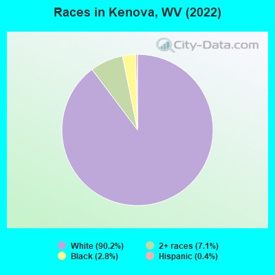
Races in Kenova detailed stats: ancestries, foreign born residents, place of birth
According to our research of West Virginia and other state lists, there were 13 registered sex offenders living in Kenova, West Virginia as of April 25, 2024.
The ratio of all residents to sex offenders in Kenova is 237 to 1.
Type |
2009 |
2010 |
2011 |
2012 |
2013 |
2014 |
2015 |
2016 |
2017 |
2018 |
2019 |
2020 |
2021 |
2022 |
|---|---|---|---|---|---|---|---|---|---|---|---|---|---|---|
| Murders (per 100,000) | 0 (0.0) | 0 (0.0) | 0 (0.0) | 0 (0.0) | 0 (0.0) | 0 (0.0) | 0 (0.0) | 0 (0.0) | 0 (0.0) | 0 (0.0) | 0 (0.0) | 0 (0.0) | 0 (0.0) | 0 (0.0) |
| Rapes (per 100,000) | 1 (30.8) | 0 (0.0) | 0 (0.0) | 0 (0.0) | 2 (64.1) | 2 (64.5) | 2 (65.2) | 1 (32.7) | 0 (0.0) | 5 (167.8) | 1 (33.2) | 0 (0.0) | 0 (0.0) | 0 (0.0) |
| Robberies (per 100,000) | 4 (123.3) | 5 (155.5) | 0 (0.0) | 1 (31.4) | 2 (64.1) | 1 (32.2) | 3 (97.8) | 1 (32.7) | 2 (66.0) | 2 (67.1) | 0 (0.0) | 0 (0.0) | 0 (0.0) | 0 (0.0) |
| Assaults (per 100,000) | 4 (123.3) | 6 (186.6) | 3 (93.2) | 9 (282.3) | 3 (96.2) | 3 (96.7) | 3 (97.8) | 0 (0.0) | 4 (132.1) | 0 (0.0) | 0 (0.0) | 0 (0.0) | 0 (0.0) | 0 (0.0) |
| Burglaries (per 100,000) | 48 (1,479) | 30 (932.8) | 21 (652.2) | 38 (1,192) | 9 (288.6) | 8 (257.8) | 5 (163.0) | 6 (196.2) | 5 (165.1) | 5 (167.8) | 2 (66.4) | 5 (170.6) | 3 (103.0) | 3 (102.0) |
| Thefts (per 100,000) | 146 (4,499) | 113 (3,514) | 89 (2,764) | 127 (3,984) | 81 (2,597) | 100 (3,223) | 97 (3,162) | 85 (2,780) | 80 (2,641) | 28 (939.9) | 33 (1,096) | 18 (614.1) | 22 (755.0) | 18 (612.2) |
| Auto thefts (per 100,000) | 4 (123.3) | 8 (248.8) | 8 (248.4) | 6 (188.2) | 3 (96.2) | 4 (128.9) | 6 (195.6) | 5 (163.5) | 7 (231.1) | 5 (167.8) | 9 (299.0) | 2 (68.2) | 5 (171.6) | 7 (238.1) |
| Arson (per 100,000) | 0 (0.0) | 2 (62.2) | 0 (0.0) | 1 (31.4) | 1 (32.1) | 0 (0.0) | 1 (32.6) | 1 (32.7) | 3 (99.0) | 0 (0.0) | 0 (0.0) | 2 (68.2) | 0 (0.0) | 0 (0.0) |
| City-Data.com crime index | 379.7 | 309.7 | 194.7 | 323.7 | 221.5 | 237.8 | 254.6 | 174.0 | 181.9 | 217.2 | 99.0 | 42.0 | 51.1 | 50.7 |
The City-Data.com crime index weighs serious crimes and violent crimes more heavily. Higher means more crime, U.S. average is 246.1. It adjusts for the number of visitors and daily workers commuting into cities.
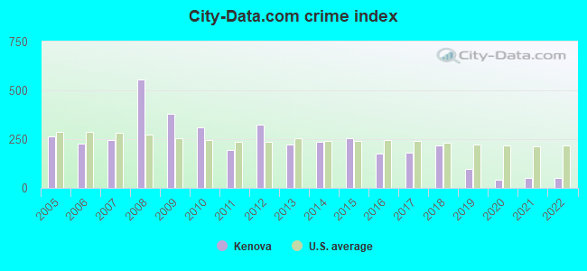
Crime rate in Kenova detailed stats: murders, rapes, robberies, assaults, burglaries, thefts, arson
Full-time law enforcement employees in 2021, including police officers: 14 (10 officers - 10 male; 0 female).
| Officers per 1,000 residents here: | 3.43 |
| West Virginia average: | 1.95 |
 Recent articles from our blog. Our writers, many of them Ph.D. graduates or candidates, create easy-to-read articles on a wide variety of topics.

 | The north/south dividing line in West Virginia? (170 replies) |
| Almost 100 years of neglecting our biggest asset: THE RIVERFRONT (22 replies) |
| Tanyard Station/The Crossing (701 replies) |
| Tiers of WV towns (5 replies) |
| Huntington continues to seek ways to improve (981 replies) |
| I-64 Expansion (58 replies) |
Latest news from Kenova, WV collected exclusively by city-data.com from local newspapers, TV, and radio stations
Ancestries: English (32.5%), American (16.3%), German (8.8%), Scotch-Irish (5.9%), Welsh (5.9%), Irish (5.3%).
Current Local Time: EST time zone
Elevation: 561 feet
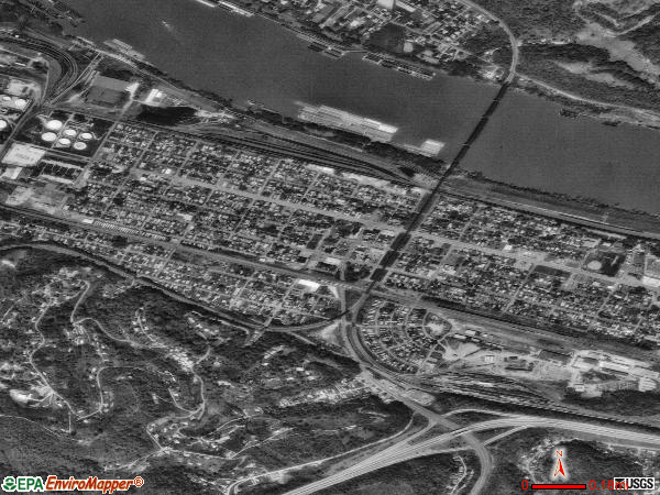
Land area: 1.21 square miles.
Population density: 2,428 people per square mile (low).
13 residents are foreign born
| This city: | 0.4% |
| West Virginia: | 1.6% |
Median real estate property taxes paid for housing units with mortgages in 2022: $667 (0.6%)
Median real estate property taxes paid for housing units with no mortgage in 2022: $538 (0.6%)
Nearest city with pop. 50,000+: Huntington, WV  (7.9 miles , pop. 51,475).
Nearest city with pop. 200,000+: Fayette, KY (107.2 miles , pop. 260,512).
Nearest city with pop. 1,000,000+: Chicago, IL (359.6 miles , pop. 2,896,016).
Nearest cities:
), ), ), )Latitude: 38.40 N, Longitude: 82.58 W
Area code commonly used in this area: 606
Kenova, West Virginia accommodation & food services, waste management - Economy and Business Data
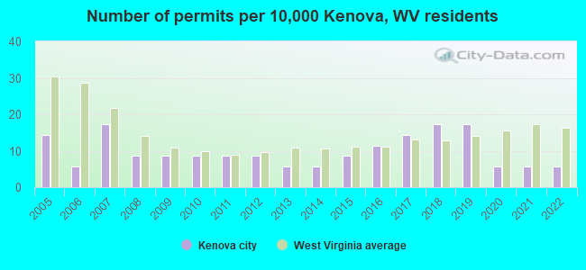
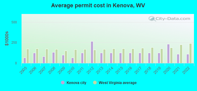
Single-family new house construction building permits:
- 2022: 2 buildings, average cost: $110,000
- 2021: 2 buildings, average cost: $110,000
- 2020: 2 buildings, average cost: $233,100
- 2019: 6 buildings, average cost: $125,000
- 2018: 6 buildings, average cost: $125,000
- 2017: 5 buildings, average cost: $125,000
- 2016: 4 buildings, average cost: $125,000
- 2015: 3 buildings, average cost: $125,000
- 2014: 2 buildings, average cost: $125,000
- 2013: 2 buildings, average cost: $125,000
- 2012: 3 buildings, average cost: $266,700
- 2011: 3 buildings, average cost: $125,000
- 2010: 3 buildings, average cost: $66,700
- 2009: 3 buildings, average cost: $100,000
- 2008: 3 buildings, average cost: $133,300
- 2007: 6 buildings, average cost: $81,700
- 2006: 2 buildings, average cost: $125,000
- 2005: 5 buildings, average cost: $67,600
| Here: | 4.1% |
| West Virginia: | 4.0% |
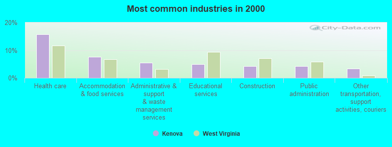
- Health care (15.8%)
- Accommodation & food services (7.7%)
- Administrative & support & waste management services (5.6%)
- Educational services (5.0%)
- Construction (4.2%)
- Public administration (4.2%)
- Other transportation, support activities, couriers (3.4%)
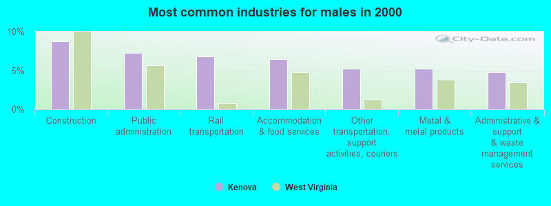
- Construction (8.8%)
- Public administration (7.3%)
- Rail transportation (6.8%)
- Accommodation & food services (6.5%)
- Other transportation, support activities, couriers (5.2%)
- Metal & metal products (5.2%)
- Administrative & support & waste management services (4.8%)
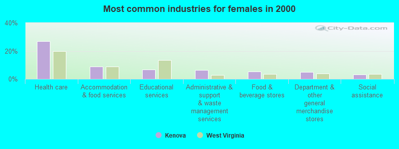
- Health care (27.1%)
- Accommodation & food services (8.8%)
- Educational services (6.7%)
- Administrative & support & waste management services (6.3%)
- Food & beverage stores (5.4%)
- Department & other general merchandise stores (5.0%)
- Social assistance (3.2%)
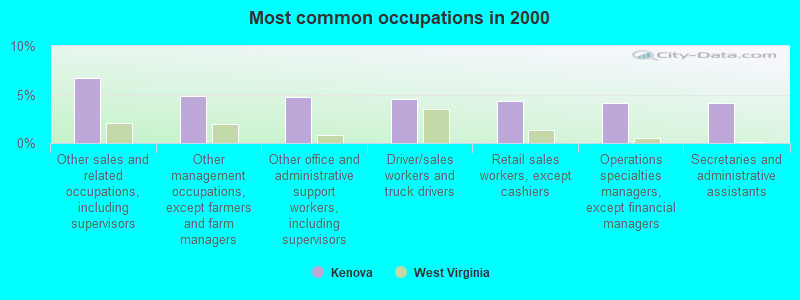
- Other sales and related occupations, including supervisors (6.7%)
- Other management occupations, except farmers and farm managers (4.8%)
- Other office and administrative support workers, including supervisors (4.8%)
- Driver/sales workers and truck drivers (4.5%)
- Retail sales workers, except cashiers (4.3%)
- Operations specialties managers, except financial managers (4.1%)
- Secretaries and administrative assistants (4.1%)
- Driver/sales workers and truck drivers (9.6%)
- Electrical equipment mechanics and other installation, maintenance, and repair workers, including supervisors (6.8%)
- Operations specialties managers, except financial managers (5.7%)
- Other sales and related occupations, including supervisors (5.6%)
- Building and grounds cleaning and maintenance occupations (5.6%)
- Laborers and material movers, hand (5.2%)
- Metal workers and plastic workers (4.6%)
- Secretaries and administrative assistants (7.8%)
- Other sales and related occupations, including supervisors (7.7%)
- Retail sales workers, except cashiers (6.3%)
- Registered nurses (6.1%)
- Other management occupations, except farmers and farm managers (5.3%)
- Other office and administrative support workers, including supervisors (5.3%)
- Health technologists and technicians (4.6%)
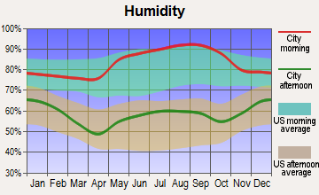
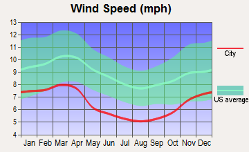
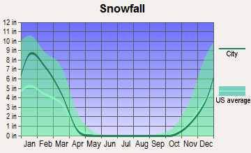
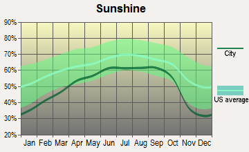
Average climate in Kenova, West Virginia
Based on data reported by over 4,000 weather stations

|
|

(lower is better)

Air Quality Index (AQI) level in 2023 was 86.3. This is about average.
| City: | 86.3 |
| U.S.: | 72.6 |
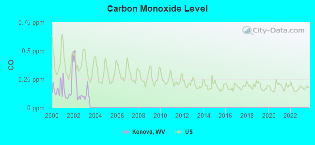
Carbon Monoxide (CO) [ppm] level in 2002 was 0.180. This is better than average. Closest monitor was 2.0 miles away from the city center.
| City: | 0.180 |
| U.S.: | 0.251 |
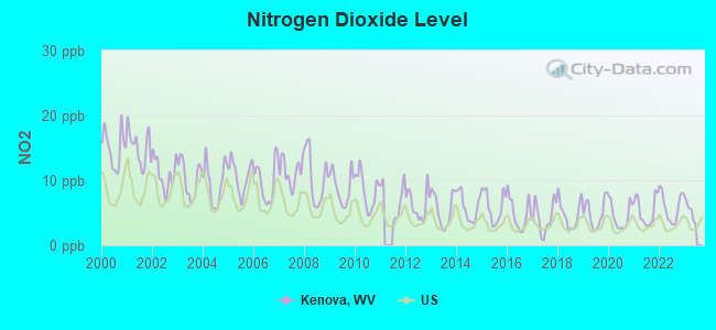
Nitrogen Dioxide (NO2) [ppb] level in 2022 was 5.87. This is about average. Closest monitor was 1.5 miles away from the city center.
| City: | 5.87 |
| U.S.: | 5.11 |
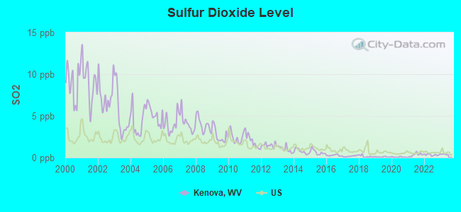
Sulfur Dioxide (SO2) [ppb] level in 2023 was 0.303. This is significantly better than average. Closest monitor was 0.6 miles away from the city center.
| City: | 0.303 |
| U.S.: | 1.515 |
Ozone [ppb] level in 2022 was 26.0. This is better than average. Closest monitor was 3.6 miles away from the city center.
| City: | 26.0 |
| U.S.: | 33.3 |
Particulate Matter (PM2.5) [µg/m3] level in 2023 was 9.96. This is worse than average. Closest monitor was 5.3 miles away from the city center.
| City: | 9.96 |
| U.S.: | 8.11 |
Tornado activity:
Kenova-area historical tornado activity is slightly above West Virginia state average. It is 55% smaller than the overall U.S. average.
On 4/23/1968, a category F5 (max. wind speeds 261-318 mph) tornado 24.0 miles away from the Kenova city center killed 7 people and injured 93 people and caused between $500,000 and $5,000,000 in damages.
On 4/8/1965, a category F3 (max. wind speeds 158-206 mph) tornado 4.4 miles away from the city center injured 3 people and caused between $50,000 and $500,000 in damages.
Earthquake activity:
Kenova-area historical earthquake activity is significantly above West Virginia state average. It is 12% greater than the overall U.S. average.On 7/27/1980 at 18:52:21, a magnitude 5.2 (5.1 MB, 4.7 MS, 5.0 UK, 5.2 UK, Class: Moderate, Intensity: VI - VII) earthquake occurred 75.3 miles away from the city center
On 8/23/2011 at 17:51:04, a magnitude 5.8 (5.8 MW, Depth: 3.7 mi) earthquake occurred 254.7 miles away from the city center
On 8/9/2020 at 12:07:37, a magnitude 5.1 (5.1 MW, Depth: 4.7 mi) earthquake occurred 156.1 miles away from the city center
On 9/7/1988 at 02:28:09, a magnitude 4.6 (4.5 MB, 4.6 LG, Class: Light, Intensity: IV - V) earthquake occurred 72.8 miles away from the city center
On 9/25/1998 at 19:52:52, a magnitude 5.2 (4.8 MB, 4.3 MS, 5.2 LG, 4.5 MW, Depth: 3.1 mi) earthquake occurred 243.1 miles away from the city center
On 4/18/2008 at 09:36:59, a magnitude 5.4 (5.1 MB, 4.8 MS, 5.4 MW, 5.2 MW) earthquake occurred 287.6 miles away from Kenova center
Magnitude types: regional Lg-wave magnitude (LG), body-wave magnitude (MB), surface-wave magnitude (MS), moment magnitude (MW)
Natural disasters:
The number of natural disasters in Wayne County (27) is a lot greater than the US average (15).Major Disasters (Presidential) Declared: 21
Emergencies Declared: 4
Causes of natural disasters: Floods: 18, Storms: 17, Landslides: 10, Mudslides: 6, Winter Storms: 3, Hurricanes: 2, Blizzard: 1, Fire: 1, Snowfall: 1, Tornado: 1, Wind: 1, Other: 1 (Note: some incidents may be assigned to more than one category).
Hospitals and medical centers in Kenova:
Other hospitals and medical centers near Kenova:
- HEARTLAND OF RIVERVIEW (Nursing Home, about 2 miles away; SOUTH POINT, OH)
- PULLEY NURSING HOME (Nursing Home, about 2 miles away; SOUTH POINT, OH)
- QUALITY CARE NURSING SERVICES (Home Health Center, about 2 miles away; SOUTH POINT, OH)
- RIVER'S BEND HEALTH CARE LLC (Nursing Home, about 3 miles away; SOUTH POINT, OH)
- SUNRISE NURSG AND REHABILITATION CTR INC (Nursing Home, about 4 miles away; ASHLAND, KY)
- HUNTINGTON VA MEDICAL CENTER (Hospital, Acute Care - Veterans Administration, about 4 miles away; HUNTINGTON, WV)
- COVENANT HOME HEALTH CARE SERVICES (Home Health Center, about 4 miles away; SOUTH POINT, OH)
Amtrak stations near Kenova:
- 7 miles: ASHLAND (99 15TH ST.) . Services: fully wheelchair accessible, enclosed waiting area, public restrooms, public payphones, vending machines, free short-term parking, free long-term parking, call for taxi service, public transit connection.
- 8 miles: HUNTINGTON (8TH AVE. & 10TH ST.) . Services: ticket office, fully wheelchair accessible, enclosed waiting area, public restrooms, public payphones, free short-term parking, free long-term parking, call for taxi service.
Colleges/universities with over 2000 students nearest to Kenova:
- Ashland Community and Technical College (about 7 miles; Ashland, KY; Full-time enrollment: 2,482)
- Marshall University (about 9 miles; Huntington, WV; FT enrollment: 11,450)
- Shawnee State University (about 33 miles; Portsmouth, OH; FT enrollment: 4,160)
- West Virginia State University (about 44 miles; Institute, WV; FT enrollment: 2,133)
- Morehead State University (about 49 miles; Morehead, KY; FT enrollment: 7,523)
- Big Sandy Community and Technical College (about 51 miles; Prestonsburg, KY; FT enrollment: 2,660)
- Maysville Community and Technical College (about 69 miles; Maysville, KY; FT enrollment: 2,969)
Public elementary/middle school in Kenova:
- KENNA ELEMENTARY SCHOOL (Students: 367, Location: 650 RT 21, Grades: PK-5)
User-submitted facts and corrections:
- The area code for Kenova, WV is 304. This area code is used in all parts of WV.
Points of interest:
Notable locations in Kenova: Jordans Landing (A), Ceredo-Kenova Memorial Public Library (B), Kenova Volunteer Fire Department Station 1 (C). Display/hide their locations on the map
Churches in Kenova include: Pentecostal Church of God (A), Kenova United Methodist Church (B), Kenova Presbyterian Church (C), First Baptist Church of Kenova (D), Church of God (E), Church of Christ (F), Bethlehem United Baptist Church (G). Display/hide their locations on the map
River: Big Sandy River (A). Display/hide its location on the map
Hotel: Hollywood Motel (901 Poplar Street).
Birthplace of: Michael W. Smith - (born 1957), singer.
Drinking water stations with addresses in Kenova and their reported violations in the past:
KENOVA MUNICIPAL WATER (Population served: 9,254, Surface water):Past health violations:Past monitoring violations:
- MCL, Monthly (TCR) - In JUL-2010, Contaminant: Coliform. Follow-up actions: St Compliance achieved (AUG-01-2010), St Public Notif requested (AUG-24-2010), St Formal NOV issued (AUG-24-2010), St Public Notif received (SEP-01-2010)
- MCL, Average - Between JUL-2006 and SEP-2006, Contaminant: Total Haloacetic Acids (HAA5). Follow-up actions: St Public Notif requested (DEC-07-2006), St Formal NOV issued (DEC-07-2006), St Compliance achieved (DEC-26-2006), St Public Notif received (NOV-19-2012)
- Monitoring and Reporting (DBP) - Between JUL-2011 and SEP-2011, Contaminant: TTHM. Follow-up actions: St Public Notif requested (NOV-02-2011), St Formal NOV issued (NOV-02-2011), St Compliance achieved (FEB-06-2012), St Public Notif received (NOV-26-2012)
- Monitoring and Reporting (DBP) - Between JUL-2011 and SEP-2011, Contaminant: Total Haloacetic Acids (HAA5). Follow-up actions: St Public Notif requested (NOV-02-2011), St Formal NOV issued (NOV-02-2011), St Compliance achieved (FEB-06-2012), St Public Notif received (NOV-26-2012)
- Monitoring and Reporting (DBP) - Between JAN-2009 and MAR-2009, Contaminant: CARBON, TOTAL. Follow-up actions: St Formal NOV issued (MAY-08-2009), St Compliance achieved (JUL-14-2009)
- Monitoring of Treatment (SWTR-Filter) - In APR-2007. Follow-up actions: St Compliance achieved (MAY-01-2007), St Public Notif requested (MAY-18-2007), St Formal NOV issued (MAY-18-2007), St Public Notif received (FEB-22-2013)
- Monitoring and Reporting (DBP) - Between JAN-2006 and MAR-2006, Contaminant: TTHM. Follow-up actions: St Compliance achieved (APR-30-2006), St Public Notif requested (MAY-04-2006), St Formal NOV issued (MAY-04-2006), St Public Notif received (NOV-19-2012)
- 26 regular monitoring violations
- 2 other older monitoring violations
| This city: | 2.2 people |
| West Virginia: | 2.4 people |
| This city: | 60.2% |
| Whole state: | 65.8% |
| This city: | 6.5% |
| Whole state: | 6.6% |
Likely homosexual households (counted as self-reported same-sex unmarried-partner households)
- Lesbian couples: 0.4% of all households
- Gay men: 0.2% of all households
4 people in group homes intended for adults in 2010
8 people in homes for the mentally retarded in 2000
3 people in other noninstitutional group quarters in 2000
Banks with branches in Kenova (2011 data):
- United Bank: Kenova Branch at 511 14th Street, branch established on 1910/12/31. Info updated 2007/09/20: Bank assets: $3,625.4 mil, Deposits: $3,023.8 mil, headquarters in Parkersburg, WV, positive income, Commercial Lending Specialization, 56 total offices, Holding Company: United Bankshares, Inc.
- Fifth Third Bank: Kenova Banking Center Branch at 1008 Oak Street, branch established on 2004/05/17. Info updated 2009/10/05: Bank assets: $114,540.4 mil, Deposits: $89,689.1 mil, headquarters in Cincinnati, OH, positive income, Commercial Lending Specialization, 1378 total offices, Holding Company: Fifth Third Bancorp
For population 15 years and over in Kenova:
- Never married: 31.4%
- Now married: 45.9%
- Separated: 0.0%
- Widowed: 5.5%
- Divorced: 17.2%
For population 25 years and over in Kenova:
- High school or higher: 92.0%
- Bachelor's degree or higher: 15.6%
- Graduate or professional degree: 5.5%
- Unemployed: 6.3%
- Mean travel time to work (commute): 15.1 minutes
| Here: | 9.0 |
| West Virginia average: | 11.1 |
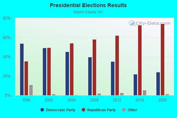
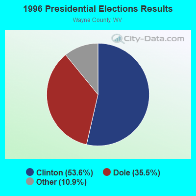
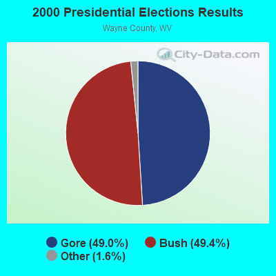
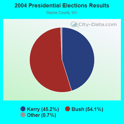
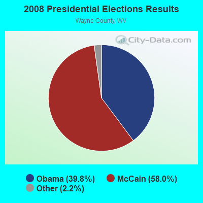
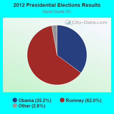


Graphs represent county-level data. Detailed 2008 Election Results
Religion statistics for Kenova, WV (based on Wayne County data)
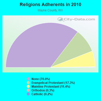
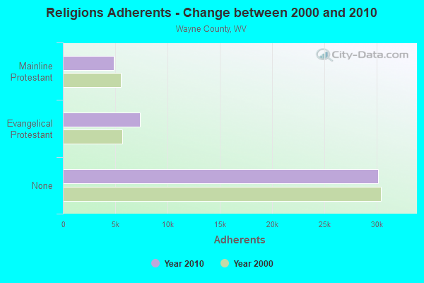
| Religion | Adherents | Congregations |
|---|---|---|
| Evangelical Protestant | 7,338 | 55 |
| Mainline Protestant | 4,840 | 27 |
| Orthodox | 115 | 3 |
| Catholic | 89 | 1 |
| Other | 2 | - |
| None | 30,097 | - |
Food Environment Statistics:
| Here: | 2.18 / 10,000 pop. |
| West Virginia: | 2.41 / 10,000 pop. |
| Wayne County: | 0.24 / 10,000 pop. |
| West Virginia: | 0.28 / 10,000 pop. |
| Wayne County: | 0.24 / 10,000 pop. |
| West Virginia: | 1.09 / 10,000 pop. |
| This county: | 6.07 / 10,000 pop. |
| West Virginia: | 5.38 / 10,000 pop. |
| Here: | 3.88 / 10,000 pop. |
| West Virginia: | 6.22 / 10,000 pop. |
| Here: | 11.7% |
| West Virginia: | 12.2% |
| Wayne County: | 35.7% |
| State: | 31.1% |
| Wayne County: | 12.1% |
| West Virginia: | 13.1% |
Health and Nutrition:
| Here: | 57.9% |
| West Virginia: | 51.8% |
| Here: | 58.3% |
| State: | 49.7% |
| Kenova: | 27.7 |
| State: | 28.6 |
| Here: | 20.3% |
| West Virginia: | 20.4% |
| Here: | 7.2% |
| State: | 9.7% |
| Kenova: | 7.1 |
| West Virginia: | 6.9 |
| Here: | 33.9% |
| West Virginia: | 34.8% |
| Kenova: | 64.0% |
| State: | 58.4% |
| This city: | 80.1% |
| State: | 78.6% |
More about Health and Nutrition of Kenova, WV Residents
| Local government employment and payroll (March 2022) | |||||
| Function | Full-time employees | Monthly full-time payroll | Average yearly full-time wage | Part-time employees | Monthly part-time payroll |
|---|---|---|---|---|---|
| Other and Unallocable | 0 | $0 | 0 | $0 | |
| Totals for Government | 0 | $0 | 0 | $0 | |
Kenova government finances - Expenditure in 2021 (per resident):
- Current Operations - Water Utilities: $1,542,000 ($526.28)
Police Protection: $1,030,000 ($351.54)
Sewerage: $673,000 ($229.69)
Regular Highways: $571,000 ($194.88)
Central Staff Services: $554,000 ($189.08)
Parks and Recreation: $336,000 ($114.68)
Solid Waste Management: $323,000 ($110.24)
Public Welfare - Other: $41,000 ($13.99)
- General - Interest on Debt: $78,000 ($26.62)
- Other Capital Outlay - General - Other: $100,000 ($34.13)
Parks and Recreation: $28,000 ($9.56)
Water Utilities: $19,000 ($6.48)
- Water Utilities - Interest on Debt: $779,000 ($265.87)
Kenova government finances - Revenue in 2021 (per resident):
- Charges - Sewerage: $1,019,000 ($347.78)
Solid Waste Management: $542,000 ($184.98)
Parks and Recreation: $154,000 ($52.56)
- Miscellaneous - Fines and Forfeits: $183,000 ($62.46)
General Revenue - Other: $48,000 ($16.38)
Interest Earnings: $1,000 ($0.34)
- Revenue - Water Utilities: $2,557,000 ($872.70)
- State Intergovernmental - Other: $42,000 ($14.33)
General Local Government Support: $14,000 ($4.78)
- Tax - Occupation and Business License - Other: $658,000 ($224.57)
Property: $533,000 ($181.91)
Public Utilities Sales: $361,000 ($123.21)
Alcoholic Beverage Sales: $60,000 ($20.48)
Other: $42,000 ($14.33)
Other License: $30,000 ($10.24)
Other Selective Sales: $5,000 ($1.71)
Kenova government finances - Debt in 2021 (per resident):
- Long Term Debt - Beginning Outstanding - Unspecified Public Purpose: $14,750,000 ($5034.13)
Outstanding Unspecified Public Purpose: $13,778,000 ($4702.39)
Retired Unspecified Public Purpose: $972,000 ($331.74)
Kenova government finances - Cash and Securities in 2021 (per resident):
- Bond Funds - Cash and Securities: $256,000 ($87.37)
- Other Funds - Cash and Securities: $1,139,000 ($388.74)
| Businesses in Kenova, WV | ||||
| Name | Count | Name | Count | |
|---|---|---|---|---|
| Advance Auto Parts | 1 | H&R Block | 1 | |
| Burger King | 1 | La-Z-Boy | 1 | |
| Curves | 1 | McDonald's | 1 | |
Strongest AM radio stations in Kenova:
- WTCR (1420 AM; 5 kW; KENOVA, WV; Owner: CAPSTAR TX LIMITED PARTNERSHIP)
- WRVC (930 AM; 5 kW; HUNTINGTON, WV; Owner: FIFTH AVENUE BROADCASTING COMPANY, INC.)
- WVHU (800 AM; 5 kW; HUNTINGTON, WV; Owner: CAPSTAR TX LIMITED PARTNERSHIP)
- WHRD (1470 AM; 5 kW; HUNTINGTON, WV; Owner: CONCORD MEDIA GROUP, INC.)
- WCMI (1340 AM; 1 kW; ASHLAND, KY; Owner: FIFTH AVENUE BROADCASTING CO., INC)
- WOKT (1040 AM; daytime; 2 kW; CANNONSBURG, KY; Owner: BIG RIVER RADIO, INC.-KY)
- WTVN (610 AM; 50 kW; COLUMBUS, OH; Owner: CITICASTERS LICENSES, L.P.)
- WLGC (1520 AM; daytime; 5 kW; GREENUP, KY; Owner: GREENUP COUNTY BROADCASTING, INC.)
- WGOH (1370 AM; 5 kW; GRAYSON, KY; Owner: CARTER COUNTY BROADCASTING CO., INC.)
- WIRO (1230 AM; 1 kW; IRONTON, OH; Owner: CAPSTAR TX LIMITED PARTNERSHIP)
- WBGS (1030 AM; daytime; 10 kW; POINT PLEASANT, WV; Owner: BIG RIVER RADIO, INC.)
- WLW (700 AM; 50 kW; CINCINNATI, OH; Owner: JACOR BROADCASTING CORPORATION)
- WZZW (1600 AM; 5 kW; MILTON, WV; Owner: CAPSTAR TX LIMITED PARTNERSHIP)
Strongest FM radio stations in Kenova:
- WRYV-FM1 (101.5 FM; HUNTINGTON, WV; Owner: LEGEND COMMUNICATIONS OF OHIO, LLC)
- WDGG (93.7 FM; ASHLAND, KY; Owner: FIFTH AVENUE B/CASTING COMPANY, INC.)
- WRVC-FM (92.7 FM; CATLETTSBURG, KY; Owner: FIFTH AVENUE BROADCASTING CO., INC)
- WKEE-FM (100.5 FM; HUNTINGTON, WV; Owner: CAPSTAR TX LIMITED PARTNERSHIP)
- WBKS (107.1 FM; IRONTON, OH; Owner: CAPSTAR TX LIMITED PARTNERSHIP)
- WBVB (97.1 FM; COAL GROVE, OH; Owner: CAPSTAR TX LIMITED PARTNERSHIP)
- WTCR-FM (103.3 FM; HUNTINGTON, WV; Owner: CAPSTAR TX LIMITED PARTNERSHIP)
- WOUL-FM (89.1 FM; IRONTON, OH; Owner: OHIO UNIVERSITY)
- WVWV (89.9 FM; HUNTINGTON, WV; Owner: WEST VIRGINIA EDUCATIONAL BROADCASTING AUTHORITY)
- WAMX (106.3 FM; MILTON, WV; Owner: CAPSTAR TX LIMITED PARTNERSHIP)
- WMEJ (91.9 FM; PROCTORVILLE, OH; Owner: MARANATHA BROADCASTING INC.)
- WPAY-FM (104.1 FM; PORTSMOUTH, OH; Owner: RADIO STATIONS WPAY/WPFB, INC.)
- WKLC-FM (105.1 FM; ST. ALBANS, WV; Owner: WKLC, INC.)
- W216AT (91.1 FM; ASHLAND, KY; Owner: AMERICAN FAMILY ASSOCIATION)
- WEMM (107.9 FM; HUNTINGTON, WV; Owner: MORTENSON BROADCASTING CO. OF WEST VIRGINIA, LLC)
- WOSP (91.5 FM; PORTSMOUTH, OH; Owner: THE OHIO STATE UNIVERSITY)
- WZAQ (92.3 FM; LOUISA, KY; Owner: LOUISA COMMUNICATIONS, INC.)
- WLGC-FM (105.7 FM; GREENUP, KY; Owner: GREENUP COUNTY BROADCASTING, INC.)
- WOHP (88.3 FM; PORTSMOUTH, OH; Owner: THE CEDARVILLE UNIVERSITY)
- WUGO (102.3 FM; GRAYSON, KY; Owner: CARTER COUNTY BROADCASTING CO., INC.)
TV broadcast stations around Kenova:
- W49BN (Channel 49; HUNTINGTON, WV; Owner: PAXSON COMMUNCATIONS LPTV, INC.)
- W05CB (Channel 5; BURLINGTON, OH; Owner: VEARL R. PENNINGTON)
- WKAS (Channel 25; ASHLAND, KY; Owner: KENTUCKY AUTHORITY FOR EDUCATIONAL TV)
- WPBY-TV (Channel 33; HUNTINGTON, WV; Owner: WEST VIRGINIA EDUCATIONAL BROADCASTING AUTHORITY)
- W14CU (Channel 14; HUNTINGTON, WV; Owner: VENTANA TELEVISION, INC.)
- WSAZ-TV (Channel 3; HUNTINGTON, WV; Owner: EMMIS TELEVISION LICENSE CORPORATION)
- WTSF (Channel 61; ASHLAND, KY; Owner: TRI STATE FAMILY BROADCASTING, INC.)
- WOWK-TV (Channel 13; HUNTINGTON, WV; Owner: WEST VIRGINIA MEDIA HOLDINGS, LLC)
- WVAH-TV (Channel 11; CHARLESTON, WV; Owner: WVAH LICENSEE, LLC)
- WCHS-TV (Channel 8; CHARLESTON, WV; Owner: WCHS LICENSEE, LLC)
- W55AT (Channel 55; HUNTINGTON, WV; Owner: CHANNEL AMERICA LPTV LIC. SUBSIDIARY)
- W36CR (Channel 36; HUNTINGTON, WV; Owner: NATIONAL MINORITY T.V., INC.)
- WPBO (Channel 42; PORTSMOUTH, OH; Owner: THE OHIO STATE UNIVERSITY)
- WHCP (Channel 30; PORTSMOUTH, OH; Owner: TELEVISION PROPERTIES, INC.)
- WLPX-TV (Channel 29; CHARLESTON, WV; Owner: PAXSON CHARLESTON LICENSE, INC.)
- National Bridge Inventory (NBI) Statistics
- 13Number of bridges
- 374ft / 114mTotal length
- $2,000,000Total costs
- 85,554Total average daily traffic
- 11,815Total average daily truck traffic
- New bridges - historical statistics
- 21900-1909
- 11910-1919
- 11920-1929
- 21930-1939
- 21960-1969
- 11980-1989
- 41990-1999
FCC Registered Antenna Towers:
41 (See the full list of FCC Registered Antenna Towers in Kenova)FCC Registered Private Land Mobile Towers:
2 (See the full list of FCC Registered Private Land Mobile Towers in Kenova, WV)FCC Registered Broadcast Land Mobile Towers:
18 (See the full list of FCC Registered Broadcast Land Mobile Towers)FCC Registered Microwave Towers:
4- CATLETTSBURG, 1352 Barger Hill Road (Lat: 38.391250 Lon: -82.588833), Type: Ltower, Structure height: 54.9 m, Overall height: 56.1 m, Call Sign: WMV925,
Assigned Frequencies: 10775.0 MHz, 10895.0 MHz, Grant Date: 01/12/2021, Expiration Date: 02/01/2031, Certifier: Carol L Tacker, Registrant: At&t Services, Inc., 208 S Akard St, 20f, Dallas, TX 75202, Phone: (855) 699-7073, Email:
- STATION, 250 Ft Sw Of Int 23rd And Beech Sts (Lat: 38.406444 Lon: -82.590139), Overall height: 24.4 m, Call Sign: WNEO805,
Assigned Frequencies: 2193.60 MHz, Grant Date: 08/16/2001, Expiration Date: 08/15/2011, Cancellation Date: 03/14/2007, Certifier: Susan P Casale, Registrant: Keller And Heckman LLP, 1001 G Street Nw Suite 500 West, Washington, DC 20001, Phone: (202) 434-4130, Fax: (202) 434-4646, Email:
- 68561, 1371 Grandview Gardens (Wv02119-A) (Lat: 38.391833 Lon: -82.590028), Type: Ltower, Structure height: 54.9 m, Overall height: 57.9 m, Call Sign: WQYR445,
Assigned Frequencies: 10815.0 MHz, 10855.0 MHz, 11095.0 MHz, 10815.0 MHz, 10855.0 MHz, 11095.0 MHz, 10815.0 MHz, 10855.0 MHz, 11095.0 MHz, 10815.0 MHz... (+17 more), Grant Date: 12/20/2016, Expiration Date: 12/20/2026, Certifier: Steve Sharkey, Registrant: T-Mobile Usa, Inc., 12920 Se 38th Street, Bellevue, WA 98006, Phone: (425) 383-8401, Email:
- 68595, 280 Malcolm Lane (Lat: 38.348778 Lon: -82.502611), Type: Mtower, Structure height: 42.7 m, Overall height: 44.2 m, Call Sign: WQYW735,
Assigned Frequencies: 10775.0 MHz, 10775.0 MHz, 10775.0 MHz, 10775.0 MHz, 10775.0 MHz, 10775.0 MHz, 10775.0 MHz, 10775.0 MHz, 10775.0 MHz, Grant Date: 02/14/2017, Expiration Date: 02/14/2027, Certifier: Steve Sharkey, Registrant: T-Mobile Usa, Inc., 12920 Se 38th Street, Bellevue, WA 98006, Phone: (425) 383-8401, Email:
FCC Registered Maritime Coast & Aviation Ground Towers:
3- Beach St Between 22nd & 23rd Sts (Lat: 38.404250 Lon: -82.575444), Type: Building, Overall height: 8 m, Call Sign: WBK,
Assigned Frequencies: 4.12640 MHz, 6.23140 MHz, 8.29540 MHz, 12.3604 MHz, 8.29840 MHz, Grant Date: 02/10/2004, Expiration Date: 04/19/2014, Cancellation Date: 02/06/2014, Certifier: Susan P Casale, Registrant: Keller And Heckman LLP, 1001 G Street Nw Suite 500 West, Washington, DC 20001, Phone: (202) 434-4100, Fax: (202) 434-4646, Email:
- 17th & River Sts (Lat: 38.404806 Lon: -82.535444), Type: Building, Overall height: 14 m, Call Sign: WHV895,
Assigned Frequencies: 156.450 MHz, 156.500 MHz, 156.600 MHz, 156.800 MHz, Grant Date: 06/08/2005, Expiration Date: 08/17/2015, Cancellation Date: 09/07/2012, Certifier: Susan P Casale, Registrant: Keller And Heckman LP, 1001 G Street Nw, Suite 500 West, Washington, DC 20001, Phone: (202) 434-4100, Fax: (202) 434-4646, Email:
- 3026 Big Sandy Rd (Lat: 38.318417 Lon: -82.569056), Type: Building, Overall height: 5 m, Call Sign: WQZ371,
Assigned Frequencies: 156.450 MHz, 156.800 MHz, 156.975 MHz, Grant Date: 01/11/1994, Expiration Date: 03/10/1999, Cancellation Date: 05/06/2001, Registrant: Pen Coal Corporation, Box 458 3026 Big Sandy Rd, Kenova, WV 25530
FCC Registered Amateur Radio Licenses:
28 (See the full list of FCC Registered Amateur Radio Licenses in Kenova)FAA Registered Aircraft:
3- Aircraft: PIPER PA-28R-180 (Category: Land, Seats: 4, Weight: Up to 12,499 Pounds, Speed: 107 mph), Engine: LYCOMING I0360 SER (180 HP) (Reciprocating)
N-Number: 3914T, N3914T, N-3914T, Serial Number: 28R-30961, Airworthiness Date: 09/12/1968, Certificate Issue Date: 01/22/2019
Registrant (Individual): Lee Bias, 1510 Oak St, Kenova, WV 25530
Deregistered: Cancel Date: 09/26/2018 - Aircraft: ADKINS GORDON L RV4 (Category: Land, Seats: 2, Weight: Up to 12,499 Pounds), Engine: LYCOMING 0-320 SERIES (180 HP) (Reciprocating)
N-Number: 567GA, N567GA, N-567GA, Serial Number: 3668, Year manufactured: 2004, Airworthiness Date: 02/04/2005, Certificate Issue Date: 07/16/2004
Registrant (Individual): Gordon L Adkins, 2151 Route 75, Kenova, WV 25530 - Aircraft: AEROSTAR INTERNATIONAL INC S-49A (Category: Sea, Weight: Up to 12,499 Pounds), Engine: None
N-Number: 5243N, N5243N, N-5243N, Serial Number: S49A-3215, Year manufactured: 2000, Airworthiness Date: 01/04/2000, Certificate Issue Date: 12/22/2010
Registrant (Individual): Donald Wayne Jr Cone, 2783 Route 75, Kenova, WV 25530
| Home Mortgage Disclosure Act Aggregated Statistics For Year 2009 (Based on 1 partial tract) | ||||||||||||
| A) FHA, FSA/RHS & VA Home Purchase Loans | B) Conventional Home Purchase Loans | C) Refinancings | D) Home Improvement Loans | E) Loans on Dwellings For 5+ Families | F) Non-occupant Loans on < 5 Family Dwellings (A B C & D) | |||||||
|---|---|---|---|---|---|---|---|---|---|---|---|---|
| Number | Average Value | Number | Average Value | Number | Average Value | Number | Average Value | Number | Average Value | Number | Average Value | |
| LOANS ORIGINATED | 9 | $93,384 | 8 | $64,596 | 20 | $82,817 | 4 | $58,550 | 1 | $401,080 | 5 | $51,838 |
| APPLICATIONS APPROVED, NOT ACCEPTED | 1 | $91,100 | 0 | $0 | 2 | $122,945 | 0 | $0 | 0 | $0 | 0 | $0 |
| APPLICATIONS DENIED | 2 | $73,565 | 2 | $66,110 | 12 | $87,808 | 4 | $36,178 | 0 | $0 | 0 | $0 |
| APPLICATIONS WITHDRAWN | 2 | $97,750 | 1 | $35,880 | 4 | $73,565 | 0 | $0 | 0 | $0 | 0 | $0 |
| FILES CLOSED FOR INCOMPLETENESS | 0 | $0 | 0 | $0 | 1 | $132,220 | 0 | $0 | 0 | $0 | 0 | $0 |
Detailed HMDA statistics for the following Tracts: 0203.00
| Private Mortgage Insurance Companies Aggregated Statistics For Year 2009 (Based on 1 partial tract) | ||||
| A) Conventional Home Purchase Loans | B) Refinancings | |||
|---|---|---|---|---|
| Number | Average Value | Number | Average Value | |
| LOANS ORIGINATED | 1 | $76,990 | 0 | $0 |
| APPLICATIONS APPROVED, NOT ACCEPTED | 1 | $41,120 | 0 | $0 |
| APPLICATIONS DENIED | 0 | $0 | 1 | $48,370 |
| APPLICATIONS WITHDRAWN | 0 | $0 | 0 | $0 |
| FILES CLOSED FOR INCOMPLETENESS | 0 | $0 | 0 | $0 |
Detailed PMIC statistics for the following Tracts: 0203.00
2002 - 2018 National Fire Incident Reporting System (NFIRS) incidents
- Fire incident types reported to NFIRS in Kenova, WV
- 21849.9%Structure Fires
- 10423.8%Outside Fires
- 7416.9%Mobile Property/Vehicle Fires
- 419.4%Other
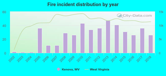 Based on the data from the years 2002 - 2018 the average number of fires per year is 26. The highest number of reported fires - 47 took place in 2013, and the least - 1 in 2003. The data has a growing trend.
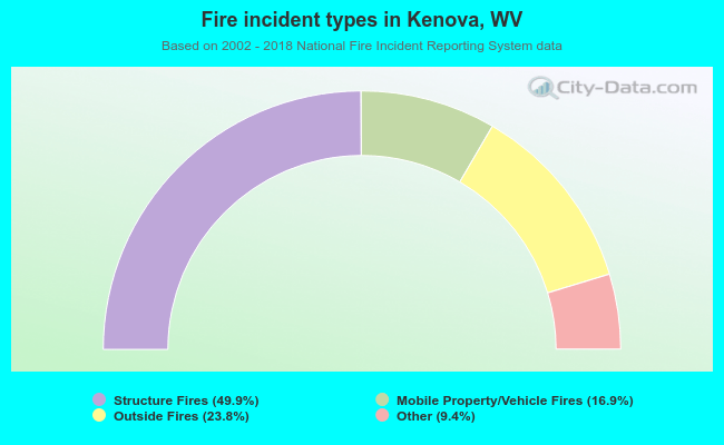 When looking into fire subcategories, the most reports belonged to: Structure Fires (49.9%), and Outside Fires (23.8%).
| Most common first names in Kenova, WV among deceased individuals | ||
| Name | Count | Lived (average) |
|---|---|---|
| James | 69 | 71.9 years |
| William | 66 | 73.4 years |
| John | 64 | 71.1 years |
| Mary | 55 | 77.8 years |
| Charles | 43 | 73.3 years |
| Robert | 26 | 68.2 years |
| George | 26 | 73.6 years |
| Frank | 21 | 75.1 years |
| Ruth | 20 | 74.0 years |
| Roy | 18 | 72.2 years |
| Most common last names in Kenova, WV among deceased individuals | ||
| Last name | Count | Lived (average) |
|---|---|---|
| Adkins | 40 | 71.3 years |
| Smith | 40 | 78.1 years |
| Ferguson | 36 | 76.2 years |
| Wilson | 29 | 78.2 years |
| Moore | 24 | 77.2 years |
| Caldwell | 23 | 73.7 years |
| Thompson | 23 | 73.2 years |
| Maynard | 22 | 73.6 years |
| Perry | 20 | 84.1 years |
| Dean | 19 | 76.8 years |
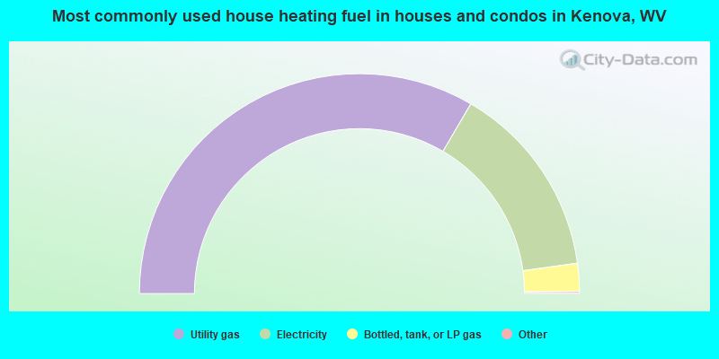
- 67.1%Utility gas
- 28.8%Electricity
- 4.1%Bottled, tank, or LP gas
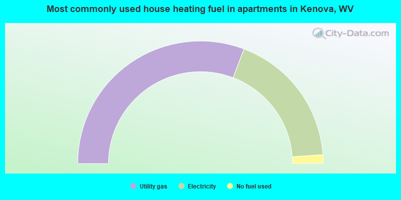
- 61.6%Utility gas
- 36.2%Electricity
- 2.3%No fuel used
Kenova compared to West Virginia state average:
- Median house value below state average.
- Unemployed percentage below state average.
- Hispanic race population percentage significantly below state average.
- Foreign-born population percentage significantly below state average.
- Number of college students below state average.