Memphis, Mississippi
Submit your own pictures of this village and show them to the world
- OSM Map
- General Map
- Google Map
- MSN Map

| Males: 54 | |
| Females: 65 |
| Median resident age: | 31.5 years |
| Mississippi median age: | 33.8 years |
Zip code: 38641
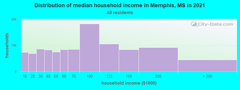
| Memphis: | $123,038 |
| MS: | $52,719 |
Estimated per capita income in 2022: $52,396 (it was $30,289 in 2000)
Estimated median house or condo value in 2022: $362,511 (it was $141,700 in 2000)
| Memphis: | $362,511 |
| MS: | $162,500 |
Mean prices in 2022: all housing units: $244,795; detached houses: $254,587; townhouses or other attached units: $140,050; in 3-to-4-unit structures: $183,520; in 5-or-more-unit structures: $378,927; mobile homes: $76,102


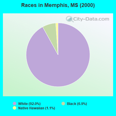
- 8092.0%White alone
- 66.9%Black alone
- 11.1%Native Hawaiian and Other
Pacific Islander alone
 Recent articles from our blog. Our writers, many of them Ph.D. graduates or candidates, create easy-to-read articles on a wide variety of topics.

 | All these states complaining about Californians moving there..... (116 replies) |
| June travel in Mississippi? (55 replies) |
| Move to Mississippi or Tennessee? (13 replies) |
| Jackson MS vs Memphis TN for Black Professional (11 replies) |
| Top 10 Counties By GDP 2021 (15 replies) |
| Stops to make (New Orleans to Memphis) (14 replies) |
Latest news from Memphis, MS collected exclusively by city-data.com from local newspapers, TV, and radio stations
Ancestries: United States (10.3%), English (5.7%), German (1.1%), Irish (1.1%).
Current Local Time: CST time zone
Elevation: 220 feet
Land area: 4.31 square miles.
Population density: 28 people per square mile (very low).

| Memphis village: | 0.2% ($275) |
| Mississippi: | 0.7% ($425) |
Nearest city with pop. 50,000+: Memphis, TN  (16.4 miles , pop. 650,100).
Nearest city with pop. 1,000,000+: Dallas, TX (409.0 miles , pop. 1,188,580).
Nearest cities:
), ), ), )Latitude: 34.93 N, Longitude: 90.14 W
Area code: 662

| Here: | 2.3% |
| Mississippi: | 2.6% |
Average climate in Memphis, Mississippi
Based on data reported by over 4,000 weather stations


(lower is better)
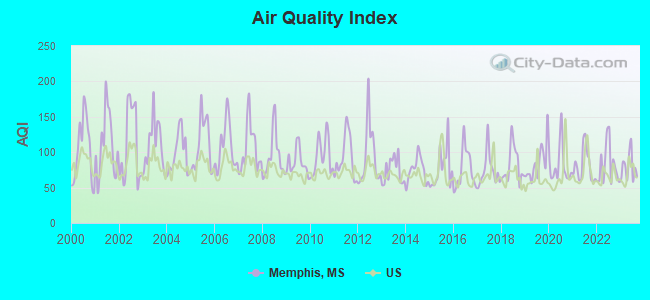
Air Quality Index (AQI) level in 2023 was 78.9. This is about average.
| City: | 78.9 |
| U.S.: | 72.6 |
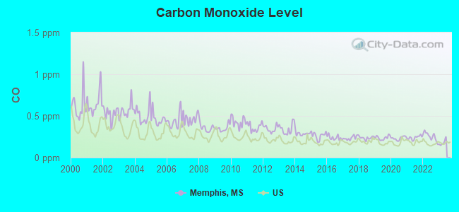
Carbon Monoxide (CO) [ppm] level in 2022 was 0.254. This is about average. Closest monitor was 10.9 miles away from the city center.
| City: | 0.254 |
| U.S.: | 0.251 |
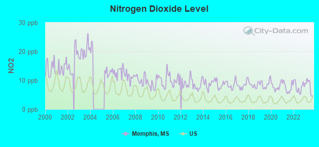
Nitrogen Dioxide (NO2) [ppb] level in 2023 was 7.96. This is significantly worse than average. Closest monitor was 8.6 miles away from the city center.
| City: | 7.96 |
| U.S.: | 5.11 |
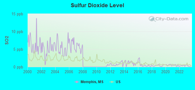
Sulfur Dioxide (SO2) [ppb] level in 2022 was 0.365. This is significantly better than average. Closest monitor was 8.6 miles away from the city center.
| City: | 0.365 |
| U.S.: | 1.515 |
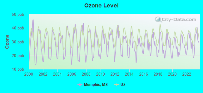
Ozone [ppb] level in 2023 was 31.9. This is about average. Closest monitor was 11.3 miles away from the city center.
| City: | 31.9 |
| U.S.: | 33.3 |
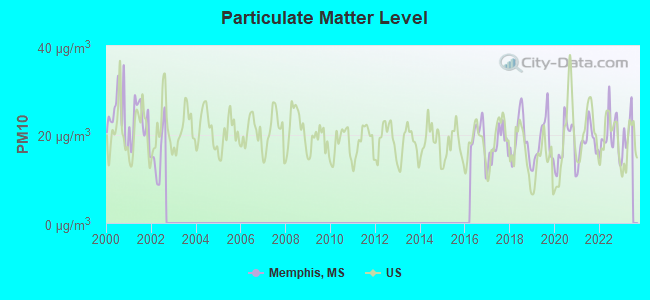
Particulate Matter (PM10) [µg/m3] level in 2022 was 19.6. This is about average. Closest monitor was 15.5 miles away from the city center.
| City: | 19.6 |
| U.S.: | 19.2 |
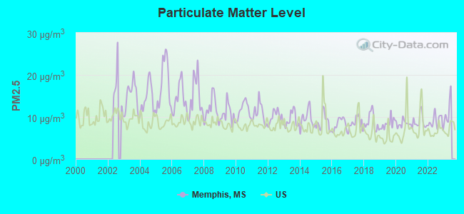
Particulate Matter (PM2.5) [µg/m3] level in 2022 was 8.96. This is about average. Closest monitor was 11.3 miles away from the city center.
| City: | 8.96 |
| U.S.: | 8.11 |
Tornado activity:
Memphis-area historical tornado activity is near Mississippi state average. It is 90% greater than the overall U.S. average.
On 3/21/1952, a category F4 (max. wind speeds 207-260 mph) tornado 26.4 miles away from the Memphis village center killed 16 people and injured 74 people and caused between $50,000 and $500,000 in damages.
On 4/24/1970, a category F3 (max. wind speeds 158-206 mph) tornado 6.4 miles away from the village center injured 18 people and caused between $500,000 and $5,000,000 in damages.
Earthquake activity:
Memphis-area historical earthquake activity is significantly above Mississippi state average. It is 372% greater than the overall U.S. average.On 3/25/1976 at 00:41:20, a magnitude 5.0 (4.9 MB, 5.0 LG, Class: Moderate, Intensity: VI - VII) earthquake occurred 50.3 miles away from the city center
On 5/4/1991 at 01:18:54, a magnitude 5.0 (4.4 MB, 4.6 LG, 5.0 LG, Depth: 3.1 mi) earthquake occurred 114.7 miles away from the city center
On 4/27/1989 at 16:47:49, a magnitude 4.7 (4.6 MB, 4.7 LG, 4.3 LG, Class: Light, Intensity: IV - V) earthquake occurred 77.6 miles away from Memphis center
On 3/25/1976 at 01:00:11, a magnitude 4.5 (4.1 MB, 4.5 LG) earthquake occurred 51.0 miles away from Memphis center
On 9/26/1990 at 13:18:51, a magnitude 5.0 (4.7 MB, 4.8 LG, 5.0 LG, Depth: 7.7 mi) earthquake occurred 158.7 miles away from the city center
On 5/4/2001 at 06:42:12, a magnitude 4.7 (4.2 MB, 4.7 LG, 4.5 LG) earthquake occurred 117.8 miles away from Memphis center
Magnitude types: regional Lg-wave magnitude (LG), body-wave magnitude (MB)
Natural disasters:
The number of natural disasters in DeSoto County (9) is smaller than the US average (15).Major Disasters (Presidential) Declared: 5
Emergencies Declared: 2
Causes of natural disasters: Floods: 5, Storms: 4, Tornadoes: 4, Freezes: 2, Winds: 2, Drought: 1, Heavy Rain: 1, Winter Storm: 1, Other: 1 (Note: some incidents may be assigned to more than one category).
Hospitals and medical centers near Memphis:
- LANDMARK OF DESOTO (Nursing Home, about 6 miles away; HORN LAKE, MS)
- GENESIS HOSPICE CARE, INC HORN LAKE (Hospital, about 8 miles away; HORN LAKE, MS)
- GOLDEN LIVINGCENTER - SOUTHAVEN (Nursing Home, about 8 miles away; SOUTHAVEN, MS)
- SOUTHAVEN HEALTH CARE CENTER (Nursing Home, about 8 miles away; SOUTHAVEN, MS)
- RCG SOUTHAVEN (Dialysis Facility, about 9 miles away; SOUTHAVEN, MS)
- BAPTIST PROGRESSIVE CARE CTR (Nursing Home, about 9 miles away; SOUTHAVEN, MS)
- DESOTO HEALTHCARE CENTER (Nursing Home, about 9 miles away; SOUTHAVEN, MS)
Amtrak station near Memphis:
- 16 miles: MEMPHIS (545 S. MAIN ST.) . Services: ticket office, partially wheelchair accessible, enclosed waiting area, public restrooms, public payphones, vending machines, free short-term parking, free long-term parking, call for car rental service, call for taxi service, public transit connection.
Colleges/universities with over 2000 students nearest to Memphis:
- Southwest Tennessee Community College (about 16 miles; Memphis, TN; Full-time enrollment: 8,043)
- University of Memphis (about 16 miles; Memphis, TN; FT enrollment: 17,427)
- Rhodes College (about 18 miles; Memphis, TN; FT enrollment: 2,052)
- Northwest Mississippi Community College (about 24 miles; Senatobia, MS; FT enrollment: 6,607)
- University of Mississippi (about 52 miles; University, MS; FT enrollment: 17,642)
- Coahoma Community College (about 53 miles; Clarksdale, MS; FT enrollment: 2,284)
- Arkansas State University-Main Campus (about 71 miles; Jonesboro, AR; FT enrollment: 12,323)
Points of interest:
Churches in Memphis include: Mount Zion Church (A), Chanels Chapel (B). Display/hide their locations on the map
| This village: | 3.2 people |
| Mississippi: | 2.6 people |
| This village: | 92.6% |
| Whole state: | 71.9% |
| This village: | 7.4% |
| Whole state: | 4.5% |
Likely homosexual households (counted as self-reported same-sex unmarried-partner households)
- Lesbian couples: 3.7% of all households
- Gay men: 0.0% of all households
For population 15 years and over in Memphis:
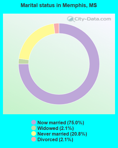
- Never married: 20.8%
- Now married: 75.0%
- Separated: 0.0%
- Widowed: 2.1%
- Divorced: 2.1%
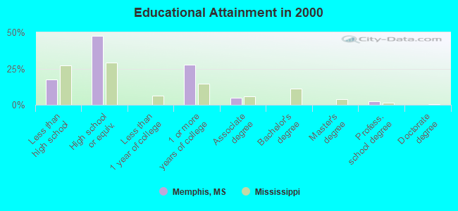
For population 25 years and over in Memphis:
- High school or higher: 82.5%
- Bachelor's degree or higher: 2.5%
- Graduate or professional degree: 2.5%
- Mean travel time to work (commute): 43.2 minutes
| Here: | 13.9 |
| Mississippi average: | 13.5 |
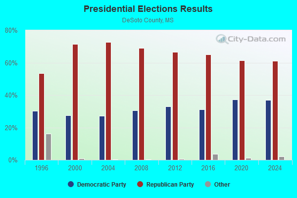

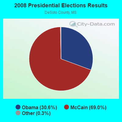

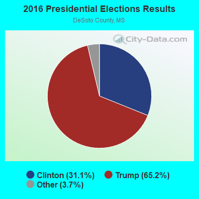
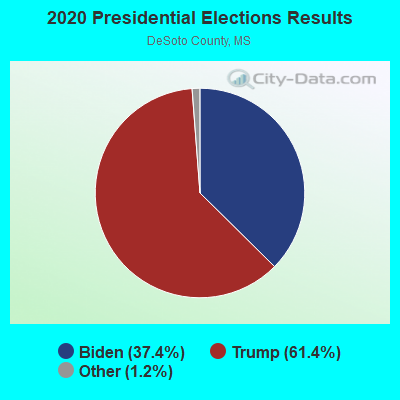
Graphs represent county-level data. Detailed 2008 Election Results
Religion statistics for Memphis, MS (based on DeSoto County data)
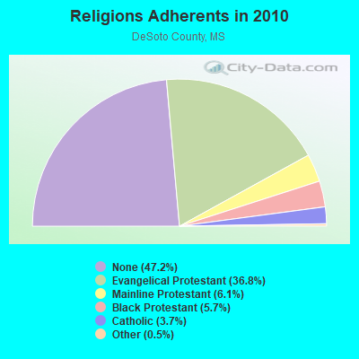
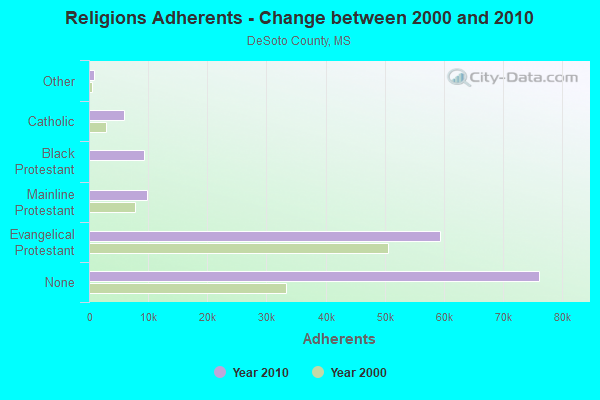
| Religion | Adherents | Congregations |
|---|---|---|
| Evangelical Protestant | 59,275 | 124 |
| Mainline Protestant | 9,807 | 26 |
| Black Protestant | 9,269 | 24 |
| Catholic | 5,928 | 3 |
| Other | 827 | 3 |
| None | 76,146 | - |
Food Environment Statistics:
| Here: | 1.07 / 10,000 pop. |
| State: | 2.08 / 10,000 pop. |
| DeSoto County: | 0.27 / 10,000 pop. |
| Mississippi: | 0.24 / 10,000 pop. |
| DeSoto County: | 0.40 / 10,000 pop. |
| Mississippi: | 0.80 / 10,000 pop. |
| Here: | 3.89 / 10,000 pop. |
| Mississippi: | 6.36 / 10,000 pop. |
| DeSoto County: | 6.44 / 10,000 pop. |
| Mississippi: | 5.03 / 10,000 pop. |
| DeSoto County: | 10.4% |
| Mississippi: | 12.3% |
| This county: | 31.6% |
| Mississippi: | 33.1% |
| This county: | 18.6% |
| Mississippi: | 14.4% |
| Local government employment and payroll (March 2002) | |||||
| Function | Full-time employees | Monthly full-time payroll | Average yearly full-time wage | Part-time employees | Monthly part-time payroll |
|---|---|---|---|---|---|
| Financial Administration | 0 | $0 | 1 | $300 | |
| Other Government Administration | 0 | $0 | 6 | $40 | |
| Police Protection - Officers | 0 | $0 | 1 | $100 | |
| Other and Unallocable | 0 | $0 | 1 | $50 | |
| Totals for Government | 0 | $0 | 9 | $490 | |
Memphis government finances - Expenditure in 2017 (per resident):
- Current Operations - Police Protection: $337,000 ($2831.93)
Sewerage: $228,000 ($1915.97)
Judicial and Legal Services: $164,000 ($1378.15)
Central Staff Services: $133,000 ($1117.65)
Local Fire Protection: $117,000 ($983.19)
Financial Administration: $107,000 ($899.16)
General - Other: $57,000 ($478.99)
General Public Buildings: $20,000 ($168.07)
- General - Interest on Debt: $3,000 ($25.21)
- Total Salaries and Wages: $344,000 ($2890.76)
Memphis government finances - Revenue in 2017 (per resident):
- Charges - Sewerage: $348,000 ($2924.37)
- Miscellaneous - Fines and Forfeits: $227,000 ($1907.56)
General Revenue - Other: $28,000 ($235.29)
- State Intergovernmental - General Local Government Support: $36,000 ($302.52)
Other: $8,000 ($67.23)
- Tax - Property: $248,000 ($2084.03)
Public Utilities Sales: $24,000 ($201.68)
Occupation and Business License - Other: $1,000 ($8.40)
Memphis government finances - Debt in 2017 (per resident):
- Long Term Debt - Beginning Outstanding - Unspecified Public Purpose: $93,000 ($781.51)
Outstanding Unspecified Public Purpose: $66,000 ($554.62)
Retired Unspecified Public Purpose: $27,000 ($226.89)
Memphis government finances - Cash and Securities in 2002 (per resident):
- Other Funds - Cash and Securities: $786,000 ($6605.04)
Strongest AM radio stations in Memphis:
- WCRV (640 AM; 50 kW; COLLIERVILLE, TN; Owner: BOTT BROADCASTING COMPANY/TENNESSEE)
- WGSF (1030 AM; 50 kW; MEMPHIS, TN; Owner: FLINN BROADCASTING CORPORATION)
- WDIA (1070 AM; 50 kW; MEMPHIS, TN; Owner: CLEAR CHANNEL BROADCASTING LICENSES, INC.)
- WBBP (1480 AM; 5 kW; MEMPHIS, TN)
- WMQM (1600 AM; 50 kW; LAKELAND, TN; Owner: WMQM, INC.)
- WJCE (680 AM; 10 kW; MEMPHIS, TN; Owner: ENTERCOM MEMPHIS LICENSE, LLC)
- KWAM (990 AM; 10 kW; MEMPHIS, TN; Owner: CONCORD MEDIA GROUP, INC.)
- WREC (600 AM; 5 kW; MEMPHIS, TN; Owner: CLEAR CHANNEL BROADCASTING LICENSES, INC.)
- WHBQ (560 AM; 5 kW; MEMPHIS, TN; Owner: FLINN BROADCASTING CORPORATION)
- WPLX (1170 AM; 10 kW; GERMANTOWN, TN; Owner: EDUCATIONAL MEDIA FOUNDATION)
- WMC (790 AM; 5 kW; MEMPHIS, TN; Owner: INFINITY RADIO OPERATIONS INC.)
- WSAO (1140 AM; daytime; 5 kW; SENATOBIA, MS; Owner: JESSE C. ROSS AND ERNESTINE A. ROSS)
- WAVN (1240 AM; 1 kW; SOUTHAVEN, MS; Owner: ARLINGTON BROADCASTING COMPANY)
Strongest FM radio stations in Memphis:
- WSRR-FM (98.1 FM; MILLINGTON, TN; Owner: KOOL BROADCASTING, INC.)
- KJMS (101.1 FM; MEMPHIS, TN; Owner: CLEAR CHANNEL BROADCASTING LICENSES, INC.)
- WMC-FM (99.7 FM; MEMPHIS, TN; Owner: INFINITY RADIO OPERATIONS INC.)
- WGKX (105.9 FM; MEMPHIS, TN; Owner: KIX BROADCASTING, INC.)
- WRVR-FM (104.5 FM; MEMPHIS, TN; Owner: ENTERCOM MEMPHIS LICENSE, LLC)
- WVIM-FM (95.3 FM; COLDWATER, MS; Owner: DESOTO COUNTY B/CING. CO.)
- KXHT (107.1 FM; MARION, AR; Owner: FLINN BROADCASTING CORPORATION)
- WMBZ (94.1 FM; GERMANTOWN, TN; Owner: ENTERCOM MEMPHIS LICENSE, LLC)
- WYPL (89.3 FM; MEMPHIS, TN; Owner: MEMPHIS/SHELBY COUNTY PUBLIC LIBRARY & INFO CNTR.)
- WYYL (96.1 FM; TUNICA, MS; Owner: FLINN BROADCASTING CORPORATION)
- WEGR (102.7 FM; MEMPHIS, TN; Owner: CLEAR CHANNEL BROADCASTING LICENSES, INC.)
- WHRK (97.1 FM; MEMPHIS, TN; Owner: CLEAR CHANNEL BROADCASTING LICENSES, INC.)
- WKNO-FM (91.1 FM; MEMPHIS, TN; Owner: MID-SOUTH PUBLIC COMMUNICATIONS FOUNDATION)
- WHAL-FM (95.7 FM; OLIVE BRANCH, MS; Owner: CLEAR CHANNEL BROADCASTING LICENSES, INC.)
- WUMR (91.7 FM; MEMPHIS, TN; Owner: THE UNIVERSITY OF MEMPHIS)
- WKNA (88.9 FM; SENATOBIA, MS; Owner: MID-SOUTH PUBLIC COMMUNICATIONS FOUNDATION)
- WQOX (88.5 FM; MEMPHIS, TN; Owner: MEMPHIS CITY SCHOOLS)
- WKVF (94.9 FM; BYHALIA, MS; Owner: EDUCATIONAL MEDIA FOUNDATION)
- WEVL (89.9 FM; MEMPHIS, TN; Owner: SOUTHERN COMMUNICATION VOLUNTEERS, INC.)
- WMPS (107.5 FM; GERMANTOWN, TN; Owner: FLINN BROADCASTING CORPORATION)
TV broadcast stations around Memphis:
- WREG-TV (Channel 3; MEMPHIS, TN; Owner: NEW YORK TIMES MANAGEMENT SERVICES)
- WMC-TV (Channel 5; MEMPHIS, TN; Owner: RAYCOM AMERICA, INC.)
- WHBQ-TV (Channel 13; MEMPHIS, TN; Owner: FOX TELEVISION STATIONS, INC.)
- WKNO (Channel 10; MEMPHIS, TN; Owner: MID-SOUTH PUBLIC COMMUNICATIONS FOUNDATION)
- WPXX-TV (Channel 50; MEMPHIS, TN; Owner: FLINN BROADCASTING CORPORATION)
- WBXP-CA (Channel 44; MEMPHIS, TN; Owner: THE BOX WORLDWIDE LLC)
- WLMT (Channel 30; MEMPHIS, TN; Owner: CLEAR CHANNEL BROADCASTING LICENSES, INC.)
- WPTY-TV (Channel 24; MEMPHIS, TN; Owner: CLEAR CHANNEL BROADCASTING LICENSES, INC.)
- W42BY (Channel 42; MEMPHIS, TN; Owner: THREE ANGELS BROADCASTING NETWORK, INC,)
- W67CV (Channel 67; MEMPHIS, TN; Owner: GEORGE S. FLINN, JR.)
- W57CG (Channel 57; MEMPHIS, TN; Owner: GEORGE S. FLINN, JR.)
- WBUY (Channel 40; HOLLY SPRINGS, MS; Owner: TRINITY BROADCASTING NETWORK)
- WMAV-TV (Channel 18; OXFORD, MS; Owner: MISSISSIPPI AUTHORITY FOR EDUCATIONAL TELEVISION)
- WJRJ-LP (Channel 59; MEMPHIS, TN; Owner: WORD OF GOD FELLOWSHIP, INC.)
- W61BP (Channel 61; MEMPHIS, TN; Owner: JIMMY BOYD)
Memphis fatal accident list:
- National Bridge Inventory (NBI) Statistics
- 6Number of bridges
- 36ft / 10.6mTotal length
- 21,700Total average daily traffic
- 2,006Total average daily truck traffic
- 25,050Total future (year 2038) average daily traffic
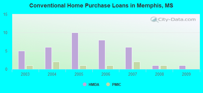
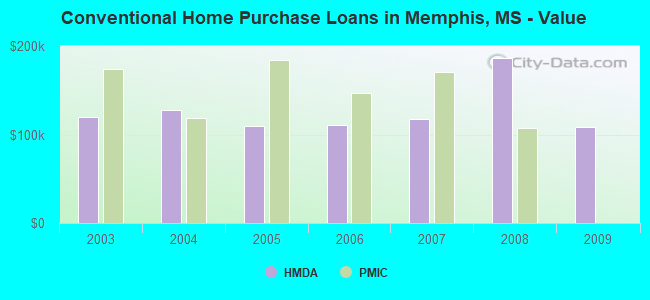
| Home Mortgage Disclosure Act Aggregated Statistics For Year 2009 (Based on 1 partial tract) | ||||||||
| A) FHA, FSA/RHS & VA Home Purchase Loans | B) Conventional Home Purchase Loans | C) Refinancings | F) Non-occupant Loans on < 5 Family Dwellings (A B C & D) | |||||
|---|---|---|---|---|---|---|---|---|
| Number | Average Value | Number | Average Value | Number | Average Value | Number | Average Value | |
| LOANS ORIGINATED | 3 | $140,597 | 1 | $108,500 | 4 | $152,905 | 1 | $58,780 |
| APPLICATIONS APPROVED, NOT ACCEPTED | 0 | $0 | 0 | $0 | 0 | $0 | 0 | $0 |
| APPLICATIONS DENIED | 0 | $0 | 0 | $0 | 3 | $145,823 | 0 | $0 |
| APPLICATIONS WITHDRAWN | 0 | $0 | 0 | $0 | 2 | $135,485 | 0 | $0 |
| FILES CLOSED FOR INCOMPLETENESS | 0 | $0 | 0 | $0 | 0 | $0 | 0 | $0 |
Detailed HMDA statistics for the following Tracts: 0701.00
| Private Mortgage Insurance Companies Aggregated Statistics For Year 2008 (Based on 1 partial tract) | ||||
| A) Conventional Home Purchase Loans | B) Refinancings | |||
|---|---|---|---|---|
| Number | Average Value | Number | Average Value | |
| LOANS ORIGINATED | 1 | $107,290 | 1 | $89,460 |
| APPLICATIONS APPROVED, NOT ACCEPTED | 0 | $0 | 0 | $0 |
| APPLICATIONS DENIED | 0 | $0 | 0 | $0 |
| APPLICATIONS WITHDRAWN | 0 | $0 | 0 | $0 |
| FILES CLOSED FOR INCOMPLETENESS | 0 | $0 | 0 | $0 |
Detailed PMIC statistics for the following Tracts: 0701.00
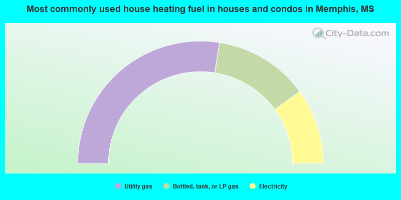
- 55.0%Utility gas
- 25.0%Bottled, tank, or LP gas
- 20.0%Electricity
Memphis compared to Mississippi state average:
- Median household income significantly above state average.
- Median house value above state average.
- Unemployed percentage significantly below state average.
- Black race population percentage significantly below state average.
- Hispanic race population percentage significantly below state average.
- Foreign-born population percentage significantly below state average.
- Renting percentage significantly below state average.
- Length of stay since moving in significantly above state average.
- Number of rooms per house significantly below state average.
- House age significantly below state average.
- Percentage of population with a bachelor's degree or higher significantly below state average.
Memphis on our top lists:
- #21 on the list of "Top 101 larger cities with the lowest real estate taxes percentage (population 50,000+)"
- #28 on the list of "Top 101 counties with the lowest percentage of residents that exercised in the past month"
- #48 on the list of "Top 101 counties with the lowest percentage of residents that visited a dentist within the past year"
- #58 on the list of "Top 101 counties with the lowest percentage of residents relocating from foreign countries between 2010 and 2011"
- #60 on the list of "Top 101 counties with the largest decrease in the number of births per 1000 residents 2000-2006 to 2007-2013 (pop 50,000+)"
- #64 on the list of "Top 101 counties with the largest number of people moving in compared to moving out (pop. 50,000+)"