Millburn, New Jersey
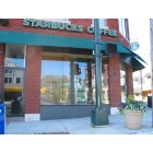
Millburn: Downtown

Millburn: Downtown
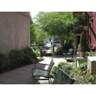
Millburn: Courtyard

Millburn: Cherry Blossom Spring in Taylor Park

Millburn: Town Hall
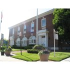
Millburn: Twon Hall
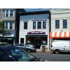
Millburn: 329 Millburn Ave.
- add
your
Submit your own pictures of this place and show them to the world
- OSM Map
- General Map
- Google Map
- MSN Map

| Males: 9,303 | |
| Females: 9,884 |
| Median resident age: | 39.2 years |
| New Jersey median age: | 36.7 years |
Zip codes: 07078.
| Millburn: | over $200,000 |
| NJ: | $96,346 |
Estimated per capita income in 2022: $145,193 (it was $76,796 in 2000)
Millburn CDP income, earnings, and wages data
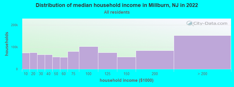
Estimated median house or condo value in 2022: over $1,000,000 (it was $529,600 in 2000)
| Millburn: | over $1,000,000 |
| NJ: | $428,900 |
Mean prices in 2022: all housing units: $574,104; detached houses: $657,086; townhouses or other attached units: $439,629; in 2-unit structures: $368,927; in 3-to-4-unit structures: $409,981; in 5-or-more-unit structures: $367,645; mobile homes: $225,735
Detailed information about poverty and poor residents in Millburn, NJ


Compare current foreclosures near Millburn, NJ:
| Photo | Address | Area | Beds / Baths | Price | Details |
|---|---|---|---|---|---|

|
#1
Wyoming Ave
Millburn, NJ 07041
|
1,991 sq. feet
|
- baths - beds |
show details | |

|
#2
Rippling Brook Dr
Millburn, NJ 07041
|
- sq. feet
|
- baths - beds |
show details | |

|
#3
Claire Dr
Warren, NJ 07059
|
3,001 sq. feet
|
2 baths 3 beds |
$806,000
|
show details |

|
#4
Ricky Dr
Basking Ridge, NJ 07920
|
1,853 sq. feet
|
2 baths 3 beds |
$509,600
|
show details |

|
#5
Russell St # G
Staten Island, NY 10308
|
642 sq. feet
|
1 baths 1 beds |
$185,000
|
show details |

|
#6
Applegate Ave
Elizabeth, NJ 07202
|
808 sq. feet
|
1 baths 2 beds |
$355,000
|
show details |

|
#7
S Orange Ave
Newark, NJ 07103
|
989 sq. feet
|
1 baths 2 beds |
$289,900
|
show details |

|
#8
Washington St Apt 2
Hoboken, NJ 07030
|
1,036 sq. feet
|
1 baths 2 beds |
$409,900
|
show details |

|
#9
Huntington Rd
Union, NJ 07083
|
1,532 sq. feet
|
2 baths 3 beds |
$539,900
|
show details |

|
#10
Summer St Apt 5e
Passaic, NJ 07055
|
1,125 sq. feet
|
1 baths 2 beds |
$345,000
|
show details |
| Photo | Address | Area | Beds / Baths | Price | Details |
|---|---|---|---|---|---|

|
#11
S Beverwyck Rd
Parsippany, NJ 07054
|
895 sq. feet
|
1 baths 3 beds |
$306,800
|
show details |

|
#12
Bloomfield Ave
Caldwell, NJ 07006
|
1,216 sq. feet
|
2 baths 2 beds |
$400,000
|
show details |

|
#13
Main St # 1
Millburn, NJ 07041
|
- sq. feet
|
- baths - beds |
show details | |

|
#14
New Ln Apt 6l
Staten Island, NY 10305
|
- sq. feet
|
1 baths 1 beds |
$284,900
|
show details |

|
#15
Willow Rd W
Staten Island, NY 10314
|
- sq. feet
|
1 baths 3 beds |
$546,000
|
show details |

|
#16
Cook Ave
Middlesex, NJ 08846
|
- sq. feet
|
1 baths 3 beds |
$244,900
|
show details |

|
#17
Station Ave
Staten Island, NY 10309
|
- sq. feet
|
1 baths 3 beds |
$679,900
|
show details |

|
#18
E Woodbridge Ave
Avenel, NJ 07001
|
- sq. feet
|
3 baths 4 beds |
$452,400
|
show details |

|
#19
Glannon Rd
Livingston, NJ 07039
|
- sq. feet
|
1 baths 3 beds |
$535,600
|
show details |

|
#20
Clove Rd Apt 6e
Staten Island, NY 10301
|
950 sq. feet
|
1 baths 1 beds |
show details |
| Photo | Address | Area | Beds / Baths | Price | Details |
|---|---|---|---|---|---|

|
#21
19th Ave
Irvington, NJ 07111
|
2,412 sq. feet
|
2 baths 6 beds |
show details | |

|
#22
Desota Ave
Woodbridge, NJ 07095
|
1,150 sq. feet
|
1 baths 3 beds |
show details | |

|
#23
Benziger Ave
Staten Island, NY 10301
|
1,350 sq. feet
|
2 baths 3 beds |
show details | |

|
#24
Luisser St
Clifton, NJ 07012
|
1,464 sq. feet
|
1 baths 3 beds |
show details | |

|
#25
New St
East Orange, NJ 07017
|
2,212 sq. feet
|
2 baths 5 beds |
show details | |

|
#26
Harmon Cove Tower # 3
Secaucus, NJ 07094
|
3,210 sq. feet
|
4 baths 4 beds |
show details | |

|
#27
Scotland Rd
South Orange, NJ 07079
|
5,320 sq. feet
|
4 baths 7 beds |
show details | |

|
#28
Clinton Ave
Clifton, NJ 07011
|
1,408 sq. feet
|
2 baths 4 beds |
show details | |

|
#29
Grand Pl
Kearny, NJ 07032
|
2,442 sq. feet
|
1 baths 3 beds |
show details | |

|
#30
Father Capodanno Blvd
Staten Island, NY 10305
|
1,344 sq. feet
|
2 baths 4 beds |
show details |
| Photo | Address | Area | Beds / Baths | Price | Details |
|---|---|---|---|---|---|

|
#31
Lord Ave
Bayonne, NJ 07002
|
1,230 sq. feet
|
2 baths 3 beds |
show details | |

|
#32
Burnet Ave
Union, NJ 07083
|
1 sq. feet
|
2 baths 4 beds |
show details | |

|
#33
Lincoln Ave Apt 6j
Staten Island, NY 10306
|
1,137 sq. feet
|
2 baths 3 beds |
show details | |

|
#34
Maple Ave
Wallington, NJ 07057
|
2,374 sq. feet
|
2 baths 4 beds |
show details | |

|
#35
Colgate Dr
Newark, NJ 07103
|
1,479 sq. feet
|
3 baths 2 beds |
show details | |

|
#36
Dey St
Montclair, NJ 07042
|
1,472 sq. feet
|
3 baths 4 beds |
show details | |

|
#37
Shores Rd
Brookside, NJ 07926
|
- sq. feet
|
2 baths 4 beds |
show details | |

|
#38
E 4th St
Bayonne, NJ 07002
|
2,168 sq. feet
|
3 baths 5 beds |
show details | |

|
#39
Waverly Dr W
Edison, NJ 08817
|
1,947 sq. feet
|
2 baths 4 beds |
show details | |

|
#40
Rhode Island Ave
East Orange, NJ 07018
|
3,698 sq. feet
|
2 baths 8 beds |
show details |
| Photo | Address | Area | Beds / Baths | Price | Details |
|---|---|---|---|---|---|

|
#41
N 18th St
Newark, NJ 07107
|
- sq. feet
|
3 baths 7 beds |
show details | |

|
#42
Barnett St
Rahway, NJ 07065
|
1,317 sq. feet
|
1 baths 3 beds |
show details | |

|
#43
Marine Ave
Brooklyn, NY 11209
|
1,116 sq. feet
|
1 baths 3 beds |
show details | |

|
#44
55th St
West New York, NJ 07093
|
1,580 sq. feet
|
3 baths 5 beds |
show details | |

|
#45
Sherman Ave
Paterson, NJ 07502
|
2,288 sq. feet
|
2 baths 5 beds |
show details | |

|
#46
Prince St
Staten Island, NY 10304
|
1,176 sq. feet
|
1 baths 3 beds |
show details | |

|
#47
Saint Pauls Ave
Staten Island, NY 10301
|
2,350 sq. feet
|
2 baths 6 beds |
show details | |

|
#48
293 Morris Ave
Newark, NJ 07103
|
3,386 sq. feet
|
6 baths 9 beds |
show details | |

|
#49
Ralph Rd
West Orange, NJ 07052
|
1,329 sq. feet
|
2 baths 3 beds |
show details | |

|
Check over 1 million property listings on Foreclosure.com!
|
browse all offers | |||

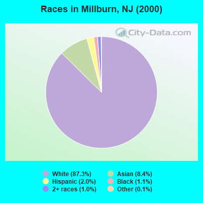
- 17,26287.3%White alone
- 1,6588.4%Asian alone
- 4042.0%Hispanic
- 2121.1%Black alone
- 1891.0%Two or more races
- 270.1%Other race alone
- 70.04%American Indian alone
- 60.03%Native Hawaiian and Other
Pacific Islander alone
Races in Millburn detailed stats: ancestries, foreign born residents, place of birth
According to our research of New Jersey and other state lists, there was 1 registered sex offender living in Millburn, New Jersey as of April 19, 2024.
The ratio of all residents to sex offenders in Millburn is 19,187 to 1.
The ratio of registered sex offenders to all residents in this city is much lower than the state average.
Type |
2009 |
2010 |
2011 |
2012 |
2013 |
2014 |
2015 |
2016 |
2017 |
2018 |
2019 |
2020 |
2021 |
2022 |
|---|---|---|---|---|---|---|---|---|---|---|---|---|---|---|
| Murders (per 100,000) | 0 (0.0) | 0 (0.0) | 0 (0.0) | 0 (0.0) | 1 (5.0) | 0 (0.0) | 0 (0.0) | 0 (0.0) | 0 (0.0) | 0 (0.0) | 0 (0.0) | 0 (0.0) | 0 (0.0) | 0 (0.0) |
| Rapes (per 100,000) | 0 (0.0) | 0 (0.0) | 0 (0.0) | 0 (0.0) | 0 (0.0) | 0 (0.0) | 1 (4.9) | 0 (0.0) | 0 (0.0) | 0 (0.0) | 0 (0.0) | 0 (0.0) | 0 (0.0) | 0 (0.0) |
| Robberies (per 100,000) | 6 (32.6) | 12 (59.6) | 10 (49.5) | 2 (9.9) | 7 (34.7) | 7 (34.5) | 5 (24.5) | 6 (29.5) | 7 (34.3) | 8 (39.5) | 5 (24.9) | 2 (10.0) | 3 (14.3) | 4 (17.8) |
| Assaults (per 100,000) | 16 (86.9) | 8 (39.7) | 12 (59.4) | 6 (29.6) | 1 (5.0) | 2 (9.9) | 3 (14.7) | 1 (4.9) | 0 (0.0) | 0 (0.0) | 1 (5.0) | 0 (0.0) | 0 (0.0) | 0 (0.0) |
| Burglaries (per 100,000) | 66 (358.3) | 55 (273.0) | 60 (296.8) | 66 (325.5) | 36 (178.4) | 31 (153.0) | 35 (171.2) | 17 (83.7) | 31 (151.8) | 27 (133.3) | 23 (114.5) | 25 (124.7) | 28 (133.7) | 23 (102.6) |
| Thefts (per 100,000) | 434 (2,356) | 437 (2,169) | 635 (3,141) | 485 (2,392) | 416 (2,062) | 304 (1,500) | 330 (1,614) | 311 (1,531) | 391 (1,915) | 325 (1,605) | 374 (1,862) | 241 (1,202) | 377 (1,800) | 487 (2,172) |
| Auto thefts (per 100,000) | 10 (54.3) | 12 (59.6) | 26 (128.6) | 15 (74.0) | 21 (104.1) | 9 (44.4) | 9 (44.0) | 19 (93.5) | 16 (78.4) | 17 (84.0) | 37 (184.2) | 40 (199.5) | 38 (181.4) | 40 (178.4) |
| Arson (per 100,000) | 1 (5.4) | 2 (9.9) | 1 (4.9) | 1 (4.9) | 0 (0.0) | 2 (9.9) | 0 (0.0) | 0 (0.0) | 0 (0.0) | 0 (0.0) | 0 (0.0) | 1 (5.0) | 0 (0.0) | 0 (0.0) |
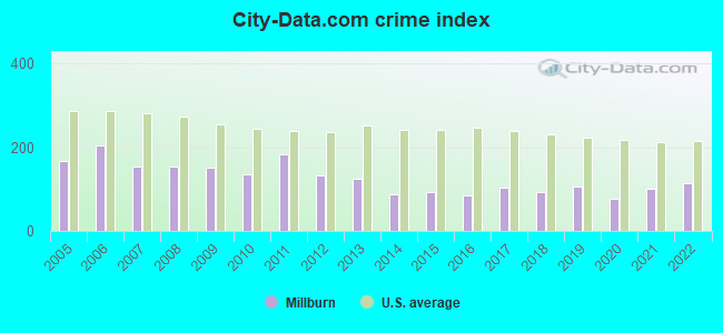
| City-Data.com crime index | 150.8 | 136.4 | 183.4 | 133.2 | 124.6 | 86.6 | 94.3 | 84.4 | 103.8 | 92.1 | 105.7 | 75.7 | 100.1 | 113.7 |
The City-Data.com crime index weighs serious crimes and violent crimes more heavily. Higher means more crime, U.S. average is 246.1. It adjusts for the number of visitors and daily workers commuting into cities.
Crime rate in Millburn detailed stats: murders, rapes, robberies, assaults, burglaries, thefts, arson
Full-time law enforcement employees in 2021, including police officers: 64 (58 officers - 56 male; 2 female).
| Officers per 1,000 residents here: | 2.77 |
| New Jersey average: | 5.53 |
 Recent articles from our blog. Our writers, many of them Ph.D. graduates or candidates, create easy-to-read articles on a wide variety of topics.

 | Curious about Change in Demographic in Millburn Short Hills (43 replies) |
| Millburn and Short Hills (10 replies) |
| Millburn vs Tenafly (34 replies) |
| School culture in Millburn and Short hills (200 replies) |
| Millburn fire code (4 replies) |
| Millburn - communities near Deerfield Elementary vs Wyoming School (7 replies) |
Latest news from Millburn, NJ collected exclusively by city-data.com from local newspapers, TV, and radio stations
Ancestries: Italian (13.5%), Irish (12.2%), Russian (11.7%), German (11.5%), English (6.8%), United States (6.6%).
Current Local Time: EST time zone
Land area: 9.38 square miles.
Population density: 2,045 people per square mile (low).
2,899 residents are foreign born (6.3% Asia, 5.4% Europe, 1.9% Latin America).
| This place: | 14.7% |
| New Jersey: | 17.5% |
| Millburn CDP: | 1.7% ($8,973) |
| New Jersey: | 2.4% ($4,047) |
Nearest city with pop. 50,000+: Union, NJ  (3.6 miles , pop. 54,405).
Nearest city with pop. 200,000+: Newark, NJ (7.1 miles , pop. 273,546).
Nearest city with pop. 1,000,000+: Manhattan, NY (18.3 miles , pop. 1,537,195).
Nearest cities:
), ), )Latitude: 40.73 N, Longitude: 74.32 W
Daytime population change due to commuting: +5,994 (+30.3%)
Workers who live and work in this place: 1,705 (19.6%)
Area codes: 973, 862
Millburn, New Jersey accommodation & food services, waste management - Economy and Business Data
| Here: | 5.6% |
| New Jersey: | 4.5% |
- Finance & insurance (18.0%)
- Professional, scientific, technical services (17.8%)
- Health care (10.5%)
- Educational services (7.7%)
- Real estate & rental & leasing (3.6%)
- Construction (2.6%)
- Chemicals (2.3%)
- Finance & insurance (22.1%)
- Professional, scientific, technical services (17.7%)
- Health care (8.1%)
- Educational services (4.4%)
- Construction (3.7%)
- Real estate & rental & leasing (3.3%)
- Administrative & support & waste management services (2.6%)
- Professional, scientific, technical services (17.8%)
- Health care (13.8%)
- Educational services (12.5%)
- Finance & insurance (12.0%)
- Real estate & rental & leasing (3.9%)
- Religious, grantmaking, civic, professional, similar organizations (3.4%)
- Social assistance (3.4%)
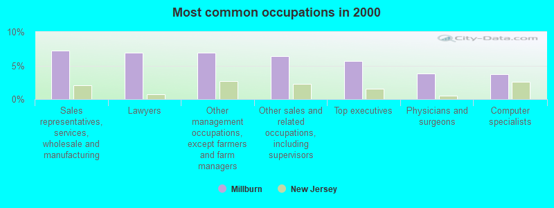
- Sales representatives, services, wholesale and manufacturing (7.3%)
- Lawyers (6.9%)
- Other management occupations, except farmers and farm managers (6.9%)
- Other sales and related occupations, including supervisors (6.4%)
- Top executives (5.7%)
- Physicians and surgeons (3.8%)
- Computer specialists (3.8%)
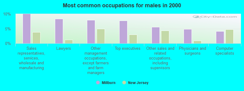
- Sales representatives, services, wholesale and manufacturing (10.0%)
- Lawyers (8.4%)
- Other management occupations, except farmers and farm managers (7.9%)
- Top executives (7.7%)
- Other sales and related occupations, including supervisors (5.5%)
- Physicians and surgeons (4.9%)
- Computer specialists (4.1%)
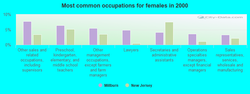
- Other sales and related occupations, including supervisors (7.7%)
- Preschool, kindergarten, elementary, and middle school teachers (6.4%)
- Other management occupations, except farmers and farm managers (5.4%)
- Lawyers (4.9%)
- Secretaries and administrative assistants (4.2%)
- Operations specialties managers, except financial managers (3.6%)
- Sales representatives, services, wholesale and manufacturing (3.3%)
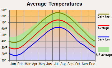
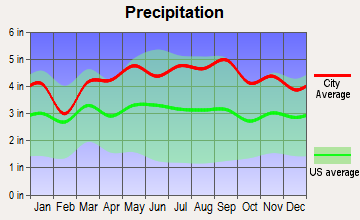
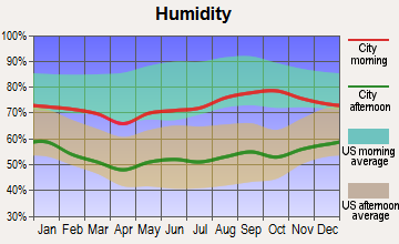
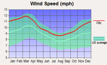
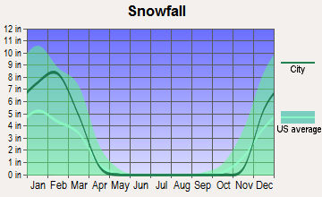
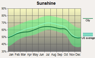
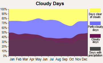
Average climate in Millburn, New Jersey
Based on data reported by over 4,000 weather stations
|
|

(lower is better)
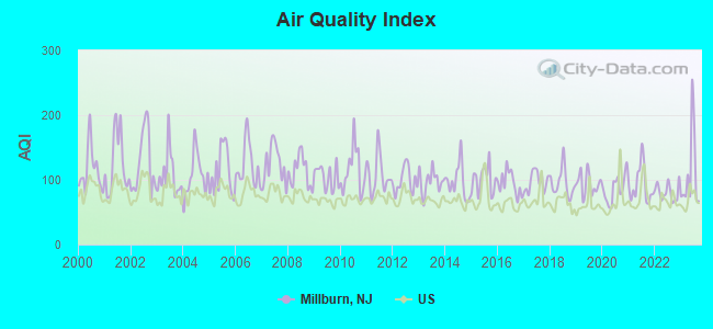
Air Quality Index (AQI) level in 2023 was 109. This is significantly worse than average.
| City: | 109 |
| U.S.: | 73 |
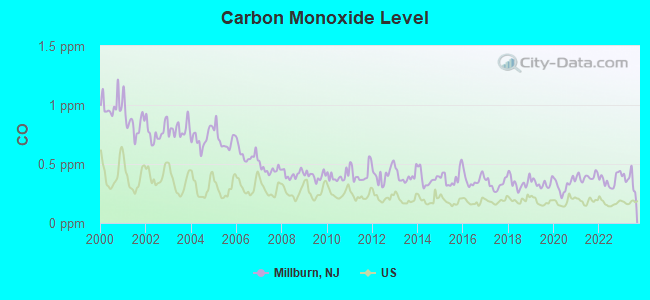
Carbon Monoxide (CO) [ppm] level in 2023 was 0.368. This is significantly worse than average. Closest monitor was 6.5 miles away from the city center.
| City: | 0.368 |
| U.S.: | 0.251 |
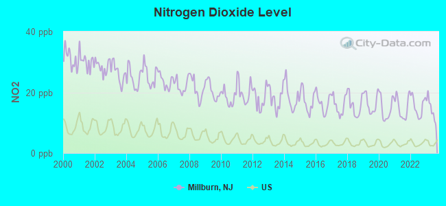
Nitrogen Dioxide (NO2) [ppb] level in 2023 was 14.5. This is significantly worse than average. Closest monitor was 6.7 miles away from the city center.
| City: | 14.5 |
| U.S.: | 5.1 |
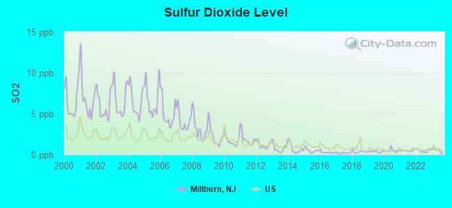
Sulfur Dioxide (SO2) [ppb] level in 2023 was 0.601. This is significantly better than average. Closest monitor was 5.9 miles away from the city center.
| City: | 0.601 |
| U.S.: | 1.515 |
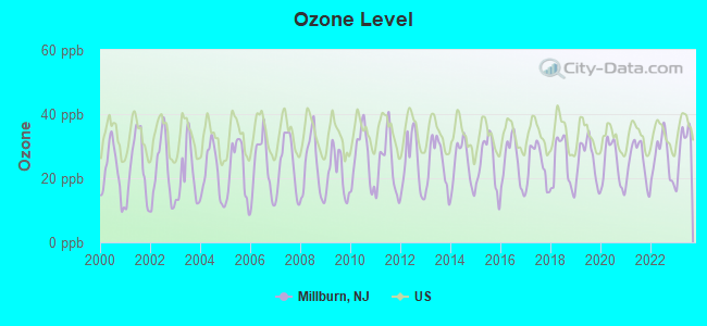
Ozone [ppb] level in 2023 was 30.0. This is about average. Closest monitor was 6.5 miles away from the city center.
| City: | 30.0 |
| U.S.: | 33.3 |
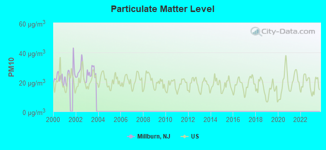
Particulate Matter (PM10) [µg/m3] level in 2003 was 26.9. This is worse than average. Closest monitor was 6.7 miles away from the city center.
| City: | 26.9 |
| U.S.: | 19.2 |
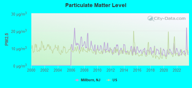
Particulate Matter (PM2.5) [µg/m3] level in 2023 was 9.25. This is about average. Closest monitor was 5.6 miles away from the city center.
| City: | 9.25 |
| U.S.: | 8.11 |
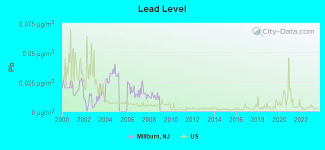
Lead (Pb) [µg/m3] level in 2008 was 0.0125. This is worse than average. Closest monitor was 7.6 miles away from the city center.
| City: | 0.0125 |
| U.S.: | 0.0093 |
Tornado activity:
Millburn-area historical tornado activity is near New Jersey state average. It is 32% smaller than the overall U.S. average.
On 5/28/1973, a category F3 (max. wind speeds 158-206 mph) tornado 10.5 miles away from the Millburn place center caused between $50,000 and $500,000 in damages.
On 5/28/1973, a category F3 tornado 22.4 miles away from the place center injured 12 people and caused between $50,000 and $500,000 in damages.
Earthquake activity:
Millburn-area historical earthquake activity is significantly above New Jersey state average. It is 68% smaller than the overall U.S. average.On 8/23/2011 at 17:51:04, a magnitude 5.8 (5.8 MW, Depth: 3.7 mi, Class: Moderate, Intensity: VI - VII) earthquake occurred 274.9 miles away from Millburn center
On 10/7/1983 at 10:18:46, a magnitude 5.3 (5.1 MB, 5.3 LG, 5.1 ML) earthquake occurred 222.7 miles away from the city center
On 1/16/1994 at 01:49:16, a magnitude 4.6 (4.6 MB, 4.6 LG, Depth: 3.1 mi, Class: Light, Intensity: IV - V) earthquake occurred 94.5 miles away from the city center
On 4/20/2002 at 10:50:47, a magnitude 5.3 (5.3 ML, Depth: 3.0 mi) earthquake occurred 263.3 miles away from Millburn center
On 4/20/2002 at 10:50:47, a magnitude 5.2 (5.2 MB, 4.2 MS, 5.2 MW, 5.0 MW) earthquake occurred 261.4 miles away from the city center
On 1/16/1994 at 00:42:43, a magnitude 4.2 (4.2 MB, 4.0 LG, Depth: 3.1 mi) earthquake occurred 93.0 miles away from the city center
Magnitude types: regional Lg-wave magnitude (LG), body-wave magnitude (MB), local magnitude (ML), surface-wave magnitude (MS), moment magnitude (MW)
Natural disasters:
The number of natural disasters in Essex County (30) is a lot greater than the US average (15).Major Disasters (Presidential) Declared: 19
Emergencies Declared: 10
Causes of natural disasters: Floods: 8, Hurricanes: 7, Storms: 7, Heavy Rains: 4, Snowstorms: 4, Winter Storms: 3, Blizzards: 2, Water Shortages: 2, Power Outage: 1, Tornado: 1, Tropical Storm: 1, Wind: 1, Other: 3 (Note: some incidents may be assigned to more than one category).

Hospitals and medical centers in Millburn:
Other hospitals and medical centers near Millburn:
- SOUTH MOUNTAIN HC (Nursing Home, about 2 miles away; VAUXHALL, NJ)
- SAINT BARNABAS MEDICAL CENTER Acute Care Hospitals (about 3 miles away; LIVINGSTON, NJ)
- SUMMIT OAKS HOSPITAL (Hospital, about 3 miles away; SUMMIT, NJ)
- NORTHFIELD MANOR NH (Nursing Home, about 3 miles away; WEST ORANGE, NJ)
- STRATFORD MANOR REHABILITATION AND CARE CENTER (Nursing Home, about 3 miles away; WEST ORANGE, NJ)
- CARE ONE AT LIVINGSTON (Nursing Home, about 3 miles away; LIVINGSTON, NJ)
- FMC HILLSIDE DIALYSIS CTR (Dialysis Facility, about 4 miles away; UNION, NJ)
Amtrak stations near Millburn:
- 7 miles: NEWARK INTERNATIONAL AIRPORT (NEWARK, ) . Services: ticket office, enclosed waiting area, public restrooms, public payphones.
- 9 miles: NEWARK (RAYMOND PLAZA WEST) . Services: ticket office, fully wheelchair accessible, enclosed waiting area, public restrooms, public payphones, snack bar, ATM, paid short-term parking, paid long-term parking, call for car rental service, taxi stand, intercity bus service, public transit connection.
- 12 miles: METROPARK (ISELIN, 100 MIDDLESEX-ESSEX TPK.) . Services: ticket office, fully wheelchair accessible, enclosed waiting area, public restrooms, public payphones, paid short-term parking, call for car rental service, taxi stand, public transit connection.
Colleges/universities with over 2000 students nearest to Millburn:
- Seton Hall University (about 4 miles; South Orange, NJ; Full-time enrollment: 7,742)
- Union County College (about 5 miles; Cranford, NJ; FT enrollment: 9,148)
- Drew University (about 6 miles; Madison, NJ; FT enrollment: 2,272)
- Kean University (about 6 miles; Union, NJ; FT enrollment: 12,648)
- Fairleigh Dickinson University-College at Florham (about 7 miles; Madison, NJ; FT enrollment: 2,690)
- University of Medicine and Dentistry of New Jersey (about 7 miles; Newark, NJ; FT enrollment: 3,210)
- Essex County College (about 8 miles; Newark, NJ; FT enrollment: 9,595)
Public high schools in Millburn:
- MILLBURN HIGH SCHOOL (Students: 1,064, Location: 462 MILLBURN AVE, Grades: 9-12)
- MILLBURN REGIONAL DAY SCHOOL (Location: 70 SPRING STREET, Grades: PK-12)
Public elementary/middle schools in Millburn:
- SOUTH MOUNTAIN SCHOOL (Students: 549, Location: 2 SOUTHERN SLOPE DRIVE, Grades: PK-5)
- WYOMING SCHOOL (Students: 318, Location: 55 MYRTLE AVE, Grades: KG-5)
- MILLBURN MIDDLE SCHOOL (Location: 25 OLD SHORT HILLS RD, Grades: 6-8)
User-submitted facts and corrections:
- Hometown of: Anne Hathaway, actress
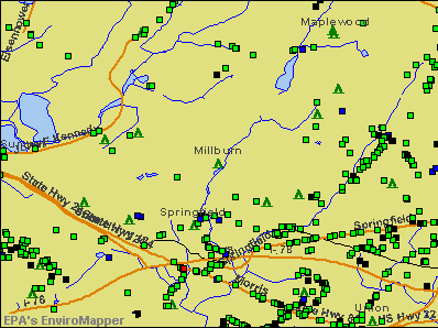
Points of interest:
Notable locations in Millburn: Millburn Station (A), Washington Rock Outlook (B), Short Hills Station (C), East Orange Golf Course (D), Millburn First Aid Squad (E), Millburn Township Fire Department Station 2 (F), Millburn Township Fire Department Headquarters (G). Display/hide their locations on the map
Shopping Center: Short Hills Mall Shopping Center (1). Display/hide its location on the map
Churches in Millburn include: Congregation B'nai Israel (A), First Baptist Church of Millburn (B), Mount Zion African Methodist Episcopal Church (C), Saint Stephen's Episcopal Church (D), Wyoming Presbyterian Church (E), Christ Church in Short Hills (F), The Church of Jesus Christ of Latter Day Saints (G), Saint Rose of Lima Church (H). Display/hide their locations on the map
Cemetery: Saint Stephens Cemetery (1). Display/hide its location on the map
Lakes and reservoirs: Canoe Brook Reservoir Number 1 (A), Canoe Brook Reservoir Number 2 (B), Diamond Mill Pond (C), Taylor Lake (D), Canoe Brook Reservoir Number One (E), Campbells Pond (F). Display/hide their locations on the map
Streams, rivers, and creeks: East Branch Rahway River (A), Taylor Brook (B), Canoe Brook (C), Slough Brook (D), Maple Brook (E), Beech Brook (F). Display/hide their locations on the map
Parks in Millburn include: White Oak Ridge Park (1), Fox Hill Reserve (2), South Mountain Reservation (3), Briant Park (4), Taylor Park (5), South Mountain Reservation (6). Display/hide their locations on the map
Birthplace of: James C. Fletcher - (1919-1991), 4th and 7th Administrators of NASA.
| This place: | 2.8 people |
| New Jersey: | 2.7 people |
| This place: | 79.9% |
| Whole state: | 70.7% |
| This place: | 2.0% |
| Whole state: | 4.9% |
Likely homosexual households (counted as self-reported same-sex unmarried-partner households)
- Lesbian couples: 0.1% of all households
- Gay men: 0.2% of all households
| This place: | 1.5% |
| Whole state: | 8.5% |
| This place: | 0.7% |
| Whole state: | 4.2% |
3 people in religious group quarters in 2000
Banks with most branches in Millburn (2011 data):
- JPMorgan Chase Bank, National Association: Millburn Banking Center Branch at 279 Millburn Avenue, branch established on 2006/05/03; Millburn Branch at 281 Millburn Avenue, branch established on 1988/10/25. Info updated 2011/11/10: Bank assets: $1,811,678.0 mil, Deposits: $1,190,738.0 mil, headquarters in Columbus, OH, positive income, International Specialization, 5577 total offices, Holding Company: Jpmorgan Chase & Co.
- Hudson City Savings Bank: Main Street Branch at 62-64 Main Street, branch established on 1974/12/21. Info updated 2012/01/09: Bank assets: $45,373.6 mil, Deposits: $25,645.6 mil, headquarters in Paramus, NJ, negative income in the last year, Mortgage Lending Specialization, 135 total offices
- Sovereign Bank, National Association: Millburn Banking Center Branch at 225 Millburn Avenue, branch established on 1977/06/27. Info updated 2012/01/31: Bank assets: $78,146.9 mil, Deposits: $48,042.9 mil, headquarters in Wilmington, DE, positive income, Commercial Lending Specialization, 718 total offices, Holding Company: Banco Santander, S.A.
- Wells Fargo Bank, National Association: Millburn at 397 Millburn Ave, branch established on 1974/12/07. Info updated 2011/04/05: Bank assets: $1,161,490.0 mil, Deposits: $905,653.0 mil, headquarters in Sioux Falls, SD, positive income, 6395 total offices, Holding Company: Wells Fargo & Company
- Bank of America, National Association: Millburn Avenue Branch at 290 Millburn Avenue, branch established on 1988/06/18. Info updated 2009/11/18: Bank assets: $1,451,969.3 mil, Deposits: $1,077,176.8 mil, headquarters in Charlotte, NC, positive income, 5782 total offices, Holding Company: Bank Of America Corporation
- Capital One, National Association: Millburn Branch at 45 Essex Street, branch established on 1994/05/16. Info updated 2011/07/01: Bank assets: $133,477.8 mil, Deposits: $97,063.7 mil, headquarters in Mclean, VA, positive income, 984 total offices, Holding Company: Capital One Financial Corporation
- PNC Bank, National Association: Millburn Branch at 170 Essex Street, branch established on 1960/02/27. Info updated 2012/03/20: Bank assets: $263,309.6 mil, Deposits: $197,343.0 mil, headquarters in Wilmington, DE, positive income, Commercial Lending Specialization, 3085 total offices, Holding Company: Pnc Financial Services Group, Inc., The
- Investors Bank: Millburn Branch at 249 Millburn Avenue, branch established on 2004/06/01. Info updated 2012/02/27: Bank assets: $10,674.9 mil, Deposits: $7,419.7 mil, headquarters in Short Hills, NJ, positive income, Commercial Lending Specialization, 86 total offices, Holding Company: Investors Bancorp, Mhc
- Valley National Bank: Millburn Branch at 181 Millburn Avenue, branch established on 1999/11/01. Info updated 2012/01/10: Bank assets: $14,186.7 mil, Deposits: $9,715.7 mil, headquarters in Wayne, NJ, positive income, Commercial Lending Specialization, 219 total offices, Holding Company: Valley National Bancorp
For population 15 years and over in Millburn:
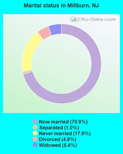
- Never married: 17.9%
- Now married: 70.9%
- Separated: 1.0%
- Widowed: 5.4%
- Divorced: 4.9%
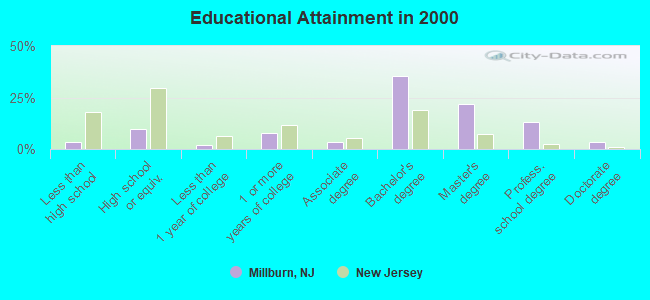
For population 25 years and over in Millburn:
- High school or higher: 96.6%
- Bachelor's degree or higher: 74.0%
- Graduate or professional degree: 38.4%
- Unemployed: 1.8%
- Mean travel time to work (commute): 35.8 minutes
| Here: | 9.4 |
| New Jersey average: | 13.1 |
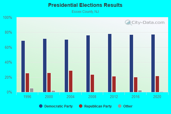
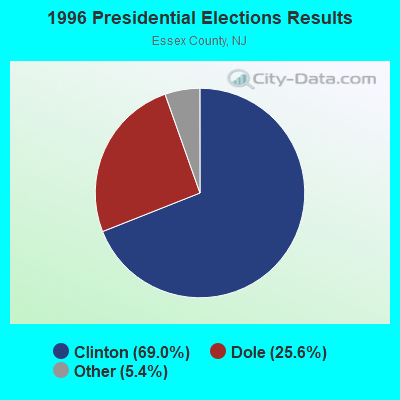

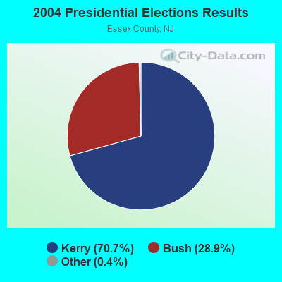
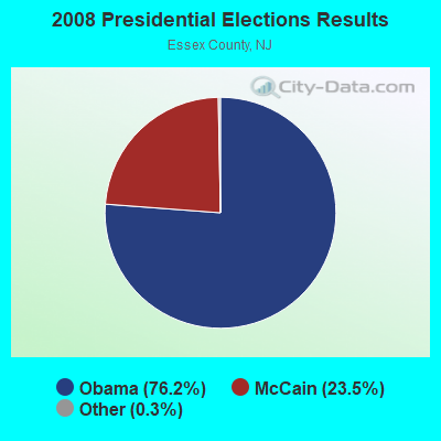
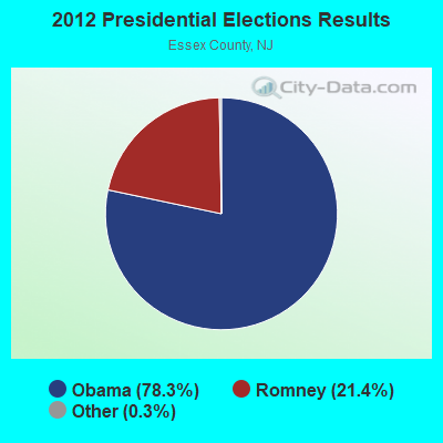
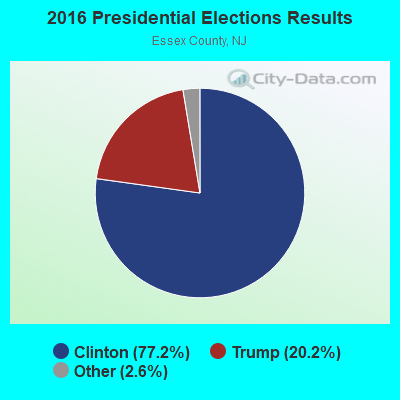
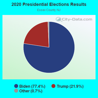
Graphs represent county-level data. Detailed 2008 Election Results
Religion statistics for Millburn, NJ (based on Essex County data)
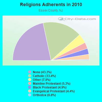
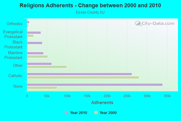
| Religion | Adherents | Congregations |
|---|---|---|
| Catholic | 261,966 | 65 |
| Other | 61,850 | 81 |
| Mainline Protestant | 41,339 | 171 |
| Black Protestant | 38,687 | 88 |
| Evangelical Protestant | 34,666 | 191 |
| Orthodox | 6,188 | 12 |
| None | 339,273 | - |
Food Environment Statistics:
| Essex County: | 3.95 / 10,000 pop. |
| New Jersey: | 2.90 / 10,000 pop. |
| This county: | 1.54 / 10,000 pop. |
| State: | 1.76 / 10,000 pop. |
| Essex County: | 0.39 / 10,000 pop. |
| State: | 0.81 / 10,000 pop. |
| This county: | 6.00 / 10,000 pop. |
| New Jersey: | 7.15 / 10,000 pop. |
| Essex County: | 9.4% |
| New Jersey: | 8.3% |
| This county: | 25.3% |
| New Jersey: | 23.3% |
| Essex County: | 16.5% |
| State: | 18.0% |
6.52% of this county's 2021 resident taxpayers lived in other counties in 2020 ($103,528 average adjusted gross income)
| Here: | 6.52% |
| New Jersey average: | 6.70% |
0.01% of residents moved from foreign countries ($16 average AGI)
Essex County: 0.01% New Jersey average: 0.01%
Top counties from which taxpayers relocated into this county between 2020 and 2021:
| from Hudson County, NJ | |
| from Union County, NJ | |
| from Kings County, NY |
7.76% of this county's 2020 resident taxpayers moved to other counties in 2021 ($101,736 average adjusted gross income)
| Here: | 7.76% |
| New Jersey average: | 7.02% |
0.02% of residents moved to foreign countries ($107 average AGI)
Essex County: 0.02% New Jersey average: 0.02%
Top counties to which taxpayers relocated from this county between 2020 and 2021:
| to Union County, NJ | |
| to Morris County, NJ | |
| to Hudson County, NJ |
| Businesses in Millburn, NJ | ||||
| Name | Count | Name | Count | |
|---|---|---|---|---|
| CVS | 1 | Nike | 1 | |
| Dunkin Donuts | 1 | PetSmart | 1 | |
| FedEx | 5 | SAS Shoes | 1 | |
| Harmon Face Values | 1 | Starbucks | 1 | |
| Jones New York | 1 | True Value | 1 | |
| New Balance | 1 | UPS | 9 | |
Strongest AM radio stations in Millburn:
- WMCA (570 AM; 50 kW; NEW YORK, NY; Owner: SALEM MEDIA OF NEW YORK, LLC)
- WOR (710 AM; 50 kW; NEW YORK, NY; Owner: BUCKLEY BROADCASTING CORPORATION)
- WINS (1010 AM; 50 kW; NEW YORK, NY; Owner: INFINITY BROADCASTING OPERATIONS, INC.)
- WEPN (1050 AM; 50 kW; NEW YORK, NY; Owner: NEW YORK AM RADIO, LLC)
- WABC (770 AM; 50 kW; NEW YORK, NY; Owner: WABC-AM RADIO, INC.)
- WADO (1280 AM; 50 kW; NEW YORK, NY; Owner: WADO-AM LICENSE CORP.)
- WBBR (1130 AM; 50 kW; NEW YORK, NY; Owner: BLOOMBERG COMMUNICATIONS INC.)
- WNSW (1430 AM; 5 kW; NEWARK, NJ; Owner: MULTICULTURAL RADIO BROADCASTING INC)
- WLIB (1190 AM; 30 kW; NEW YORK, NY; Owner: ICBC BROADCAST HOLDINGS-NY, INC.)
- WSNR (620 AM; 20 kW; JERSEY CITY, NJ)
- WJDM (1530 AM; 10 kW; ELIZABETH, NJ; Owner: RADIO UNICA OF NEW YORK LICENSE CORP)
- WNYC (820 AM; 10 kW; NEW YORK, NY; Owner: WNYC RADIO)
- WFAN (660 AM; 50 kW; NEW YORK, NY; Owner: INFINITY BROADCASTING OPERATIONS, INC.)
Strongest FM radio stations in Millburn:
- WRKS (98.7 FM; NEW YORK, NY; Owner: EMMIS RADIO LICENSE CORP OF NEW YORK)
- WFME (94.7 FM; NEWARK, NJ; Owner: FAMILY STATIONS, INC.)
- WFMU (91.1 FM; EAST ORANGE, NJ; Owner: AURICLE COMMUNICATIONS)
- WSOU (89.5 FM; SOUTH ORANGE, NJ; Owner: SETON HALL UNIVERSITY)
- WNEW (102.7 FM; NEW YORK, NY; Owner: INFINITY BROADCASTING OPERATIONS, INC.)
- WNYC-FM (93.9 FM; NEW YORK, NY; Owner: WNYC RADIO)
- WPAT-FM (93.1 FM; PATERSON, NJ; Owner: WPAT LICENSING, INC.)
- WQCD (101.9 FM; NEW YORK, NY; Owner: EMMIS RADIO LICENSE CORPORATION)
- WKTU (103.5 FM; LAKE SUCCESS, NY; Owner: AMFM RADIO LICENSES, LLC)
- WCAA (105.9 FM; NEWARK, NJ; Owner: WADO-AM LICENSE CORP. ("WADO"))
- WBAI (99.5 FM; NEW YORK, NY; Owner: PACIFICA FOUNDATION, INC.)
- WBLS (107.5 FM; NEW YORK, NY; Owner: ICBC BROADCAST HOLDINGS-NY, INC.)
- WLTW (106.7 FM; NEW YORK, NY; Owner: AMFM NEW YORK LICENSES, LLC)
- WQXR-FM (96.3 FM; NEW YORK, NY; Owner: THE NEW YORK TIMES ELECTRONIC MEDIA COMPANY)
- WSKQ-FM (97.9 FM; NEW YORK, NY; Owner: WSKQ LICENSING, INC.)
- WXRK (92.3 FM; NEW YORK, NY; Owner: INFINITY BROADCASTING OPERATIONS, INC.)
- WAXQ (104.3 FM; NEW YORK, NY; Owner: AMFM NEW YORK LICENSES, LLC)
- WHTZ (100.3 FM; NEWARK, NJ; Owner: AMFM RADIO LICENSES, L.L.C.)
- WWPR-FM (105.1 FM; NEW YORK, NY; Owner: AMFM RADIO LICENSES, L.L.C.)
- WQHT (97.1 FM; NEW YORK, NY; Owner: EMMIS LICENSE CORPORATION OF NEW YORK)
TV broadcast stations around Millburn:
- WPXO-LP (Channel 34; EAST ORANGE, NJ; Owner: PAXSON COMMUNICATIONS LPTV, INC.)
- WCBS-TV (Channel 2; NEW YORK, NY; Owner: CBS BROADCASTING INC.)
- WNYW (Channel 5; NEW YORK, NY; Owner: FOX TELEVISION STATIONS, INC.)
- WABC-TV (Channel 7; NEW YORK, NY; Owner: AMERICAN BROADCASTING COMPANIES, INC)
- WPIX (Channel 11; NEW YORK, NY; Owner: WPIX, INC.)
- WWOR-TV (Channel 9; SECAUCUS, NJ; Owner: FOX TELEVISION STATIONS, INC.)
- WPXN-TV (Channel 31; NEW YORK, NY; Owner: PAXSON COMMUNICATIONS LICENSE COMPANY, LLC)
- WNBC (Channel 4; NEW YORK, NY; Owner: NATIONAL BROADCASTING COMPANY, INC.)
- WNET (Channel 13; NEWARK, NJ; Owner: EDUCATIONAL BROADCASTING CORPORATION)
- WXTV (Channel 41; PATERSON, NJ; Owner: WXTV LICENSE PARTNERSHIP, G.P.)
- WNJU (Channel 47; LINDEN, NJ; Owner: WNJU LICENSE CORPORATION)
- WFUT (Channel 68; NEWARK, NJ; Owner: UNIVISION NEW YORK LLC)
- WNYE-TV (Channel 25; NEW YORK, NY; Owner: NEW YORK CITY BOARD OF EDUCATION)
- WXNY-LP (Channel 32; NEW YORK, NY; Owner: ISLAND BROADCASTING COMPANY)
- WKOB-LP (Channel 53; NEW YORK, NY; Owner: WKOB COMMUNICATIONS, INC.)
- WEBR-CA (Channel 17; MANHATTAN, NY; Owner: K LICENSEE INC.)
- WRNN-LP (Channel 57; NYACK, NY; Owner: LP NYACK LIMITED PARTNERSHIP)
- WLBX-LP (Channel 22; CRANFORD, NJ; Owner: RENARD COMMUNICATIONS CORP.)
- W60AI (Channel 60; NEW YORK, NY; Owner: VENTANA TELEVISION, INC.)
- W54CZ (Channel 54; MORRISTOWN, NJ; Owner: WLNY-TV, INC.)
- WNXY-LP (Channel 26; NEW YORK, NY; Owner: ISLAND BROADCASTING COMPANY)
- WNJB (Channel 58; NEW BRUNSWICK, NJ; Owner: NEW JERSEY PUBLIC BROADCASTING AUTHORITY)
- W33BS (Channel 33; DARIEN, CT; Owner: CT&T BROADCASTING, INC.)
- WNYN-LP (Channel 39; NEW YORK, NY; Owner: ISLAND BROADCASTING COMPANY)
- WNYX-LP (Channel 35; NEW YORK, NY; Owner: ISLAND BROADCASTING COMPANY)
- National Bridge Inventory (NBI) Statistics
- 26Number of bridges
- 154ft / 47.0mTotal length
- $13,770,000Total costs
- 1,037,099Total average daily traffic
- 49,236Total average daily truck traffic
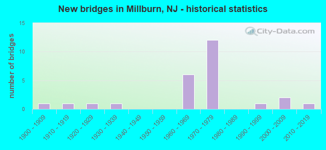
- New bridges - historical statistics
- 11900-1909
- 11910-1919
- 11920-1929
- 11930-1939
- 61960-1969
- 121970-1979
- 11990-1999
- 22000-2009
- 12010-2019
FCC Registered Broadcast Land Mobile Towers:
6- Hartshorne & High View Dr (Lat: 40.733444 Lon: -74.349583), Call Sign: KNDJ509, Licensee ID: L00100941,
Assigned Frequencies: 155.295 MHz, Grant Date: 06/05/2003, Expiration Date: 04/07/2013, Cancellation Date: 05/05/2011, Registrant: Millburn Short Hills Volunteer First Aid Squad Inc, Millburn, NJ 07041, Phone: (973) 564-7005
- Kennedy Pky (Lat: 40.792611 Lon: -74.306250), Call Sign: WFU911, Licensee ID: L00083803,
Assigned Frequencies: 469.825 MHz, Grant Date: 08/31/2004, Expiration Date: 09/08/2014, Cancellation Date: 07/15/2014, Registrant: Mall At Short Hills, Rt 124 & Jfk Pky, Short Hills, NJ 07078, Phone: (201) 376-7350
- Lat: 40.719944 Lon: -74.314194, Call Sign: WQDK417,
Assigned Frequencies: 152.990 MHz, 153.170 MHz, 153.282 MHz, 153.290 MHz, 153.327 MHz, 153.432 MHz, 154.482 MHz, 159.952 MHz, 159.990 MHz, 160.095 MHz, Grant Date: 07/09/2015, Expiration Date: 09/16/2025, Certifier: Tony Gorelov, Registrant: Triangle Communications, LLC, 2362 Waldheim Avenue, Scotch Plains, NJ 07076, Phone: (908) 518-0911, Fax: (908) 518-0915, Email:
- Lat: 40.718056 Lon: -74.307222, Call Sign: WQNC798,
Assigned Frequencies: 462.237 MHz, 467.237 MHz, 462.312 MHz, 467.312 MHz, 467.437 MHz, Grant Date: 12/21/2010, Expiration Date: 12/21/2020, Cancellation Date: 02/20/2021, Certifier: Walter Brocious, Registrant: Advanced Wireless Communication, 20809 Kensington Blvd, Lakeville, MN 55044-8353, Phone: (952) 469-0226, Fax: (952) 469-0170, Email:
- ShopRite #298, 220 Main St (Lat: 40.718056 Lon: -74.307500), Call Sign: WRPJ257,
Assigned Frequencies: 462.237 MHz, 467.237 MHz, 462.312 MHz, 467.312 MHz, 467.437 MHz, Grant Date: 02/10/2022, Expiration Date: 02/10/2032, Certifier: Walter Broscius, Registrant: Advanced Wireless Communications, 20809 Kensington Blvd, Lakeville, MN 55044, Phone: (952) 469-5400, Fax: (952) 469-0170, Email:
- Lat: 40.717500 Lon: -74.305028, Call Sign: WRYZ296,
Assigned Frequencies: 451.412 MHz, 451.437 MHz, 451.537 MHz, 451.587 MHz, 451.637 MHz, 452.787 MHz, 456.387 MHz, 456.412 MHz, 456.437 MHz, 456.537 MHz... (+4 more), Grant Date: 10/05/2023, Expiration Date: 10/05/2033, Certifier: Fabian Desouza, Registrant: Augusta Communications, 113 Cherry Street, Augusta, GA 30907, Phone: (706) 855-0404, Fax: (706) 855-2878, Email:
FCC Registered Microwave Towers:
1- NY54XC387, 132 Spring Street (Lat: 40.722861 Lon: -74.310389), Type: Building, Structure height: 32 m, Call Sign: WQQV313,
Assigned Frequencies: 23125.0 MHz, 23125.0 MHz, 23125.0 MHz, 23125.0 MHz, Grant Date: 03/08/2013, Expiration Date: 03/08/2023, Cancellation Date: 06/10/2014, Certifier: Kyle B Entz, Registrant: Sprint Nextel Corporation, 12502 Sunrise Valley Drive, Reston, VA 20196, Phone: (703) 433-4000, Fax: (703) 433-4483
FCC Registered Amateur Radio Licenses:
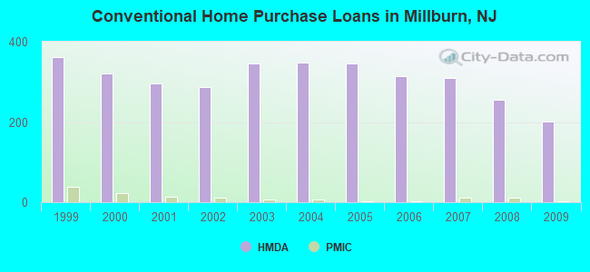
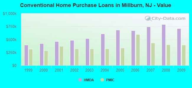
15 (See the full list of FCC Registered Amateur Radio Licenses in Millburn)| Home Mortgage Disclosure Act Aggregated Statistics For Year 2009 (Based on 4 full tracts) | ||||||||||||
| A) FHA, FSA/RHS & VA Home Purchase Loans | B) Conventional Home Purchase Loans | C) Refinancings | D) Home Improvement Loans | E) Loans on Dwellings For 5+ Families | F) Non-occupant Loans on < 5 Family Dwellings (A B C & D) | |||||||
|---|---|---|---|---|---|---|---|---|---|---|---|---|
| Number | Average Value | Number | Average Value | Number | Average Value | Number | Average Value | Number | Average Value | Number | Average Value | |
| LOANS ORIGINATED | 6 | $448,833 | 202 | $710,926 | 847 | $507,959 | 19 | $393,316 | 1 | $1,900,000 | 10 | $293,900 |
| APPLICATIONS APPROVED, NOT ACCEPTED | 0 | $0 | 24 | $893,208 | 51 | $526,412 | 1 | $356,000 | 0 | $0 | 3 | $1,025,000 |
| APPLICATIONS DENIED | 3 | $446,333 | 31 | $637,839 | 162 | $630,840 | 4 | $202,250 | 0 | $0 | 7 | $471,857 |
| APPLICATIONS WITHDRAWN | 1 | $229,000 | 29 | $697,931 | 116 | $464,767 | 4 | $525,500 | 0 | $0 | 1 | $417,000 |
| FILES CLOSED FOR INCOMPLETENESS | 2 | $619,500 | 9 | $580,444 | 43 | $488,395 | 0 | $0 | 0 | $0 | 2 | $410,000 |
Detailed HMDA statistics for the following Tracts: 0200.00 , 0201.00, 0202.00, 0203.00
| Private Mortgage Insurance Companies Aggregated Statistics For Year 2009 (Based on 2 full tracts) | ||||
| A) Conventional Home Purchase Loans | B) Refinancings | |||
|---|---|---|---|---|
| Number | Average Value | Number | Average Value | |
| LOANS ORIGINATED | 2 | $393,000 | 0 | $0 |
| APPLICATIONS APPROVED, NOT ACCEPTED | 2 | $493,000 | 1 | $420,000 |
| APPLICATIONS DENIED | 0 | $0 | 0 | $0 |
| APPLICATIONS WITHDRAWN | 0 | $0 | 0 | $0 |
| FILES CLOSED FOR INCOMPLETENESS | 0 | $0 | 0 | $0 |
Detailed PMIC statistics for the following Tracts: 0200.00 , 0201.00, 0202.00, 0203.00
2003 - 2018 National Fire Incident Reporting System (NFIRS) incidents
- Fire incident types reported to NFIRS in Millburn, NJ
- 40269.8%Structure Fires
- 11119.3%Outside Fires
- 549.4%Mobile Property/Vehicle Fires
- 91.6%Other
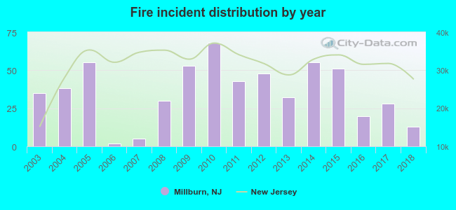 Based on the data from the years 2003 - 2018 the average number of fires per year is 36. The highest number of reported fire incidents - 68 took place in 2010, and the least - 2 in 2006. The data has a decreasing trend.
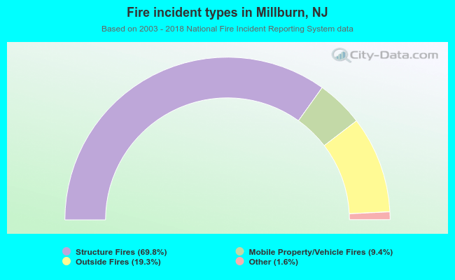 When looking into fire subcategories, the most reports belonged to: Structure Fires (69.8%), and Outside Fires (19.3%).
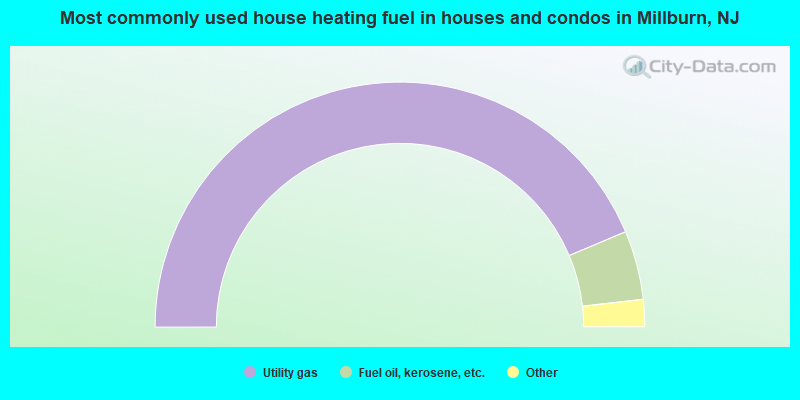
- 87.3%Utility gas
- 9.1%Fuel oil, kerosene, etc.
- 3.0%Electricity
- 0.6%Bottled, tank, or LP gas

- 75.0%Utility gas
- 13.2%Fuel oil, kerosene, etc.
- 7.9%Electricity
- 2.2%Bottled, tank, or LP gas
- 1.7%No fuel used
Millburn compared to New Jersey state average:
- Median household income above state average.
- Median house value significantly above state average.
- Unemployed percentage significantly below state average.
- Black race population percentage significantly below state average.
- Hispanic race population percentage significantly below state average.
- Foreign-born population percentage below state average.
- Renting percentage significantly below state average.
- Length of stay since moving in significantly above state average.
- Number of rooms per house significantly below state average.
- House age significantly below state average.
- Percentage of population with a bachelor's degree or higher significantly above state average.
Millburn on our top lists:
- #2 on the list of "Top 101 cities with largest percentage of males in occupations: lawyers (population 5,000+)"
- #4 on the list of "Top 101 cities with largest percentage of females in occupations: lawyers (population 5,000+)"
- #4 on the list of "Top 101 cities with the most people taking railroad to work (population 5,000+)"
- #6 on the list of "Top 101 cities with largest percentage of females in occupations: operations specialties managers except financial managers (population 5,000+)"
- #7 on the list of "Top 101 cities with largest percentage of males in occupations: sales representatives, services, wholesale and manufacturing (population 5,000+)"
- #8 on the list of "Top 101 cities with largest percentage of males in occupations: financial managers (population 5,000+)"
- #14 on the list of "Top 101 cities with largest percentage of females in occupations: physicians and surgeons (population 5,000+)"
- #25 on the list of "Top 101 cities with largest percentage of males in industries: finance and insurance (population 5,000+)"
- #51 on the list of "Top 101 cities with largest percentage of females in industries: paper and paper products merchant wholesalers (population 5,000+)"
- #54 on the list of "Top 101 cities with largest percentage of males in industries: apparel, fabrics, and notions merchant wholesalers (population 5,000+)"
- #56 on the list of "Top 101 cities with largest percentage of females in industries: jewelry, luggage, and leather goods stores (population 5,000+)"
- #59 on the list of "Top 100 cities with highest median household income (pop. 5,000+)"
- #60 on the list of "Top 101 cities with largest percentage of males in industries: health care (population 5,000+)"
- #64 on the list of "Top 100 cities with highest median house value (pop. 5,000+)"
- #67 on the list of "Top 101 cities with largest percentage of females in industries: religious, grantmaking, civic, professional, and similar organizations (population 5,000+)"
- #78 on the list of "Top 101 cities with largest percentage of females in industries: professional, scientific, and technical services (population 5,000+)"
- #83 on the list of "Top 101 cities with largest percentage of females in industries: alcoholic beverages merchant wholesalers (population 5,000+)"
- #84 on the list of "Top 101 cities with largest percentage of females in industries: apparel, fabrics, and notions merchant wholesalers (population 5,000+)"
- #93 on the list of "Top 101 cities with largest percentage of females in industries: chemicals (population 5,000+)"
- #93 on the list of "Top 101 cities with largest percentage of females in industries: publishing, and motion picture and sound recording industries (population 5,000+)"
- #2 (07078) on the list of "Top 101 zip codes with the largest percentage of taxpayers reporting taxable interest in 2012 (pop 5,000+)"
- #3 (07078) on the list of "Top 101 zip codes with the highest average reported salary/wage in 2012 (pop 5,000+)"
- #4 (07078) on the list of "Top 101 zip codes with the largest percentage of taxpayers using charity contributions deductions in 2012 (pop 5,000+)"
- #4 (07078) on the list of "Top 101 zip codes with the largest percentage of taxpayers reporting net capital gain/loss in 2012 (pop 5,000+)"
- #9 (07078) on the list of "Top 101 zip codes with the highest 2012 average Adjusted Gross Income (AGI) for individuals (pop 5,000+)"
- #10 (07078) on the list of "Top 101 zip codes with the highest 2012 average taxable interest for individuals (pop 5,000+)"
- #12 (07078) on the list of "Top 101 zip codes with the highest 2012 average reported profit/loss from business (pop 5,000+)"
- #86 (07078) on the list of "Top 101 zip codes with the largest percentage of Russian first ancestries"
- #7 on the list of "Top 101 counties with the highest Nitrogen Dioxide air pollution readings in 2012 (ppm)"
- #9 on the list of "Top 101 counties with the lowest percentage of residents that keep firearms around their homes"
- #19 on the list of "Top 101 counties with the most Black Protestant adherents"
- #20 on the list of "Top 101 counties with highest percentage of residents voting for Obama (Democrat) in the 2012 Presidential Election (pop. 50,000+)"
- #23 on the list of "Top 101 counties with the most Black Protestant congregations (pop. 50,000+)"

|
|
Total of 303 patent applications in 2008-2024.