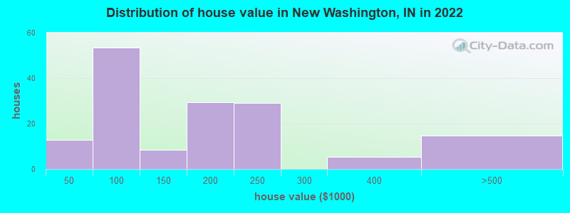
Estimated median house or condo value in 2022: $121,567 (it was $72,700 in 2000)
New Washington:
$121,567
IN:
$208,700
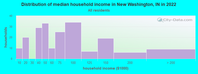
Mean prices in 2022:all housing units: $143,295; detached houses: $143,001March 2022 cost of living index in New Washington: 81.8 (low, U.S. average is 100)
Latest news from New Washington, IN collected exclusively by city-data.com from local newspapers, TV, and radio stations
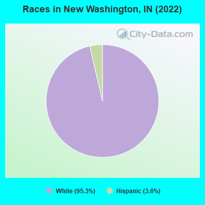
Ancestries: American (26.7%), English (15.9%), Italian (15.4%), European (5.6%), Scotch-Irish (5.1%), German (4.1%).
Current Local Time: EST time zone
Elevation: 721 feet
Land area: 5.22 square miles.
Population density: 108 people per square mile (very low).
Median real estate property taxes paid for housing units with mortgages in 2022: $1,215 (0.6%) Median real estate property taxes paid for housing units with no mortgage in 2022: $389 (0.4%)
Nearest city with pop. 50,000+: Louisville, KY (25.7 miles , pop. 256,231).
Nearest city with pop. 1,000,000+: Chicago, IL (253.3 miles , pop. 2,896,016).
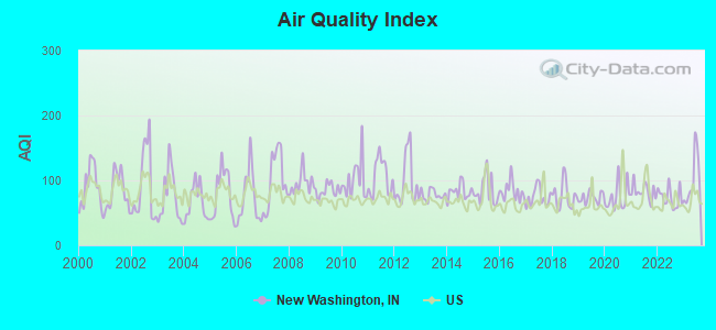
Air Quality Index (AQI) level in 2023 was 101. This is worse than average.
City:
101
U.S.:
73
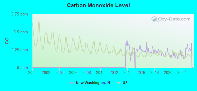
Carbon Monoxide (CO) [ppm] level in 2022 was 0.203. This is better than average.Closest monitor was 23.7 miles away from the city center.
City:
0.203
U.S.:
0.251
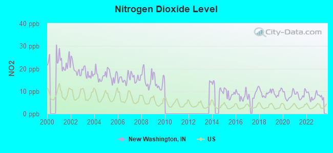
Nitrogen Dioxide (NO2) [ppb] level in 2022 was 7.88. This is significantly worse than average.Closest monitor was 10.6 miles away from the city center.
City:
7.88
U.S.:
5.11
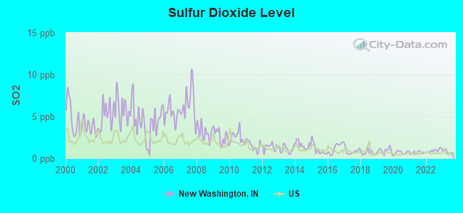
Sulfur Dioxide (SO2) [ppb] level in 2023 was 0.755. This is significantly better than average.Closest monitor was 6.9 miles away from the city center.
City:
0.755
U.S.:
1.515
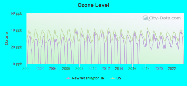
Ozone [ppb] level in 2023 was 32.1. This is about average.Closest monitor was 13.4 miles away from the city center.
City:
32.1
U.S.:
33.3
Particulate Matter (PM10) [µg/m3] level in 2022 was 16.9. This is about average.Closest monitor was 15.2 miles away from the city center.
City:
16.9
U.S.:
19.2
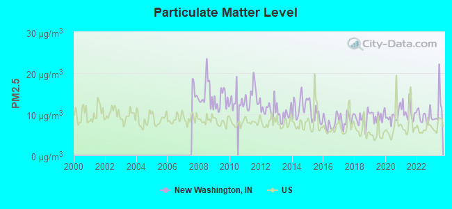
Particulate Matter (PM2.5) [µg/m3] level in 2023 was 11.2. This is worse than average.Closest monitor was 13.4 miles away from the city center.
City:
11.2
U.S.:
8.1
Tornado activity:
New Washington-area historical tornado activity is near Indiana state average. It is 78% greater than the overall U.S. average.
On 4/3/1974, a category F5 (max. wind speeds 261-318 mph) tornado 9.8 miles away from the New Washington place center killed 6 peopleand injured 86 peopleand causedbetween $50,000,000 and $500,000,000 in damages.
On 4/3/1974, a category F4 (max. wind speeds 207-260 mph) tornado 11.3 miles away from the place center killed 11 peopleand injured 190 peopleand causedbetween $50,000,000 and $500,000,000 in damages.
Earthquake activity:
New Washington-area historical earthquake activity is significantly above Indiana state average. It is 96% greater than the overall U.S. average.
On 4/18/2008 at 09:36:59, a magnitude 5.4 (5.1 MB, 4.8 MS, 5.4 MW, 5.2 MW, Class: Moderate, Intensity: VI - VII) earthquake occurred 127.1 miles away from the city center On 7/27/1980 at 18:52:21, a magnitude 5.2 (5.1 MB, 4.7 MS, 5.0 UK, 5.2 UK) earthquake occurred 90.1 miles away from New Washington center On 4/18/2008 at 09:36:59, a magnitude 5.2 (5.2 MW, Depth: 8.9 mi) earthquake occurred 127.1 miles away from the city center On 6/10/1987 at 23:48:54, a magnitude 5.1 (4.9 MB, 4.4 MS, 4.6 MS, 5.1 LG) earthquake occurred 127.8 miles away from the city center On 6/18/2002 at 17:37:15, a magnitude 5.0 (4.3 MB, 4.6 MW, 5.0 LG) earthquake occurred 127.9 miles away from New Washington center On 4/18/2008 at 15:14:16, a magnitude 4.8 (4.5 MB, 4.8 MW, 4.6 MW, Class: Light, Intensity: IV - V) earthquake occurred 124.9 miles away from New Washington center Magnitude types: regional Lg-wave magnitude (LG), body-wave magnitude (MB), surface-wave magnitude (MS), moment magnitude (MW)
Natural disasters:
The number of natural disasters in Clark County (17) is near the US average (15). Major Disasters (Presidential) Declared: 13 Emergencies Declared: 2
Causes of natural disasters: Floods: 9, Storms: 9, Tornadoes: 6, Winds: 2, Winter Storms: 2, Blizzard: 1, Flash Flood: 1, Hurricane: 1, Snow: 1, Other: 1 (Note: some incidents may be assigned to more than one category).
Hospitals and medical centers near New Washington:
MEDICAL CENTER HOME HEALTH CAR (Home Health Center, about 10 miles away; CHARLESTOWN, IN)
SAINT CATHERINE REGIONAL HOSPITAL Acute Care Hospitals (about 10 miles away; CHARLESTOWN, IN)
COMMUNITY SKILLED CARE (Nursing Home, about 10 miles away; CHARLESTOWN, IN)
HANOVER NURSING CENTER (Nursing Home, about 11 miles away; HANOVER, IN)
THORNTON TERRACE HEALTH CAMPUS (Nursing Home, about 12 miles away; HANOVER, IN)
SIGNATURE HEALTHCARE OF TRIMBLE COUNTY (Nursing Home, about 13 miles away; BEDFORD, KY)
LONGWORTH VILLA (Nursing Home, about 13 miles away; CHARLESTOWN, IN)
Notable locations in New Washington: New Washington Fire Department (A), New Washington Volunteer Fire Department (B). Display/hide their locations on the map
Clark County has a predicted average indoor radon screening level greater than 4 pCi/L (pico curies per liter) - Highest Potential
Average household size:
This place:
2.4 people
Indiana:
2.5 people
Percentage of family households:
This place:
68.1%
Whole state:
66.9%
Percentage of households with unmarried partners:
This place:
7.1%
Whole state:
6.9%
Likely homosexual households (counted as self-reported same-sex unmarried-partner households)
Lesbian couples: 1.3% of all households
Gay men: 0.0% of all households
5 people in other noninstitutional group quarters in 2000
Banks with branches in New Washington (2011 data):
The New Washington State Bank: at 402 E Main Street, branch established on 1908/03/08. Info updated 2006/11/03: Bank assets: $226.7 mil, Deposits: $199.5 mil, local headquarters, positive income, Commercial Lending Specialization, 8 total offices, Holding Company: New Independent Bancshares, Inc.
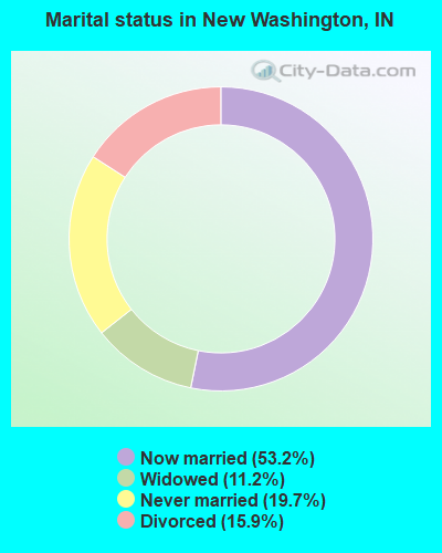
For population 15 years and over in New Washington:
Never married: 19.7%
Now married: 53.2%
Separated: 0.0%
Widowed: 11.2%
Divorced: 15.9%
For population 25 years and over in New Washington:
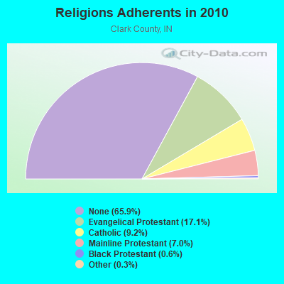
Religion statistics for New Washington, IN (based on Clark County data)
Religion
Adherents
Congregations
Evangelical Protestant
18,804
76
Catholic
10,150
8
Mainline Protestant
7,663
46
Black Protestant
661
4
Other
340
2
None
72,614
-
Source: Clifford Grammich, Kirk Hadaway, Richard Houseal, Dale E.Jones, Alexei Krindatch, Richie Stanley and Richard H.Taylor. 2012. 2010 U.S.Religion Census: Religious Congregations & Membership Study. Association of Statisticians of American Religious Bodies. Jones, Dale E., et al. 2002. Congregations and Membership in the United States 2000. Nashville, TN: Glenmary Research Center. Graphs represent county-level data
New Washington Tower, Lat: 38.563778 Lon: -85.537556, Type: Tank, Structure height: 41.1 m, Overall height: 42.3 m, Call Sign: WQIC977, Licensee ID: L01198668, Assigned Frequencies: 3650.00 MHz, Grant Date: 01/08/2008, Expiration Date: 01/08/2018, Cancellation Date: 03/10/2018, Certifier: Gerard E Dupont Iii, Registrant: Avolutia, LLC Dba Shelby Broadband, 148 Citizens Blvd, Simpsonville, KY 40067, Phone: (502) 722-9292, Fax: (866) 467-9048, Email:
New Washington Tower, Lat: 38.563778 Lon: -85.537556, Type: Tank, Structure height: 41.1 m, Overall height: 42.3 m, Call Sign: WQIC977, Licensee ID: L01198668, Assigned Frequencies: 3650.00 MHz, Grant Date: 01/08/2008, Expiration Date: 01/08/2018, Cancellation Date: 03/10/2018, Certifier: Gerard E Dupont Iii, Registrant: Avolutia, LLC Dba Shelby Broadband, 148 Citizens Blvd, Simpsonville, KY 40067, Phone: (502) 722-9292, Fax: (866) 467-9048, Email:
New Washington Tower, Lat: 38.563778 Lon: -85.537556, Type: Tank, Structure height: 41.1 m, Overall height: 42.3 m, Call Sign: WQIC977, Licensee ID: L01198668, Assigned Frequencies: 3650.00 MHz, Grant Date: 01/08/2008, Expiration Date: 01/08/2018, Cancellation Date: 03/10/2018, Certifier: Gerard E Dupont Iii, Registrant: Avolutia, LLC Dba Shelby Broadband, 148 Citizens Blvd, Simpsonville, KY 40067, Phone: (502) 722-9292, Fax: (866) 467-9048, Email:
New Washington Tower, Lat: 38.563778 Lon: -85.537556, Type: Tank, Structure height: 41.1 m, Overall height: 42.3 m, Call Sign: WQIC977, Licensee ID: L01198668, Assigned Frequencies: 3650.00 MHz, Grant Date: 01/08/2008, Expiration Date: 01/08/2018, Cancellation Date: 03/10/2018, Certifier: Gerard E Dupont Iii, Registrant: Avolutia, LLC Dba Shelby Broadband, 148 Citizens Blvd, Simpsonville, KY 40067, Phone: (502) 722-9292, Fax: (866) 467-9048, Email:
9LV0135A, 7529 New Washington - Bethlehem Rd. (022829 / New Washington) (Lat: 38.564417 Lon: -85.532361), Type: Ltower, Structure height: 75.9 m, Overall height: 78.3 m, Call Sign: WQVJ202, Assigned Frequencies: 11265.0 MHz, 11265.0 MHz, 11265.0 MHz, 11265.0 MHz, 11265.0 MHz, 11265.0 MHz, 11265.0 MHz, 11265.0 MHz, Grant Date: 02/27/2015, Expiration Date: 02/27/2025, Cancellation Date: 02/12/2024, Certifier: David Werblow, Registrant: T-Mobile License LLC, 12920 Se 38th St, Bellevue, WA 98006, Phone: (425) 383-8401, Fax: (425) 383-4040, Email:
New Washington Water, 400 E 1st St (Lat: 38.563778 Lon: -85.537556), Type: Tank, Structure height: 30.5 m, Call Sign: WRDY309, Assigned Frequencies: 11405.0 MHz, 11405.0 MHz, 11405.0 MHz, 11405.0 MHz, 11405.0 MHz, 11405.0 MHz, 11405.0 MHz, 11405.0 MHz, Grant Date: 08/19/2019, Expiration Date: 08/19/2029, Certifier: Timothy W Carpenter, Registrant: Intelpath, Hinsdale, IL 60522, Phone: (312) 841-9188, Email:
FCC Registered Amateur Radio Licenses:
2
Call Sign: N4SQB, Licensee ID: L00152794, Grant Date: 07/08/2021, Expiration Date: 09/17/2031, Registrant: Robert T Weller, 5406 Bethlehem New Washington Rd., New Washington, IN 47162
Call Sign: N6KEC, Licensee ID: L01171691, Grant Date: 05/21/2016, Expiration Date: 07/12/2026, Registrant: Jacqueline J Haycox, 7305 New Washington - Bethlehem Rd., New Washington, IN 47162
FAA Registered Aircraft:
1
Aircraft: PIPER PA-24-180 (Category: Land, Seats: 4, Weight: Up to 12,499 Pounds, Speed: 120 mph), Engine: LYCOMING O&VO-360 SER (180 HP) (Reciprocating) N-Number: 5677P, N5677P, N-5677P, Serial Number: 24-749, Year manufactured: 1959, Airworthiness Date: 02/06/1959, Certificate Issue Date: 03/21/2018 Registrant (Individual): Jonathan P Yeager, 1115 Mcintyre Rd, New Washington, IN 47162
Home Mortgage Disclosure Act Aggregated Statistics For Year 2009 (Based on 1 partial tract)
A) FHA, FSA/RHS & VA Home Purchase Loans
B) Conventional Home Purchase Loans
C) Refinancings
D) Home Improvement Loans
F) Non-occupant Loans on < 5 Family Dwellings (A B C & D)
G) Loans On Manufactured Home Dwelling (A B C & D)
Number
Average Value
Number
Average Value
Number
Average Value
Number
Average Value
Number
Average Value
Number
Average Value
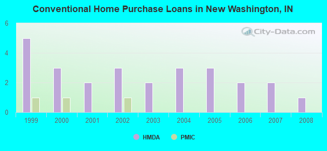
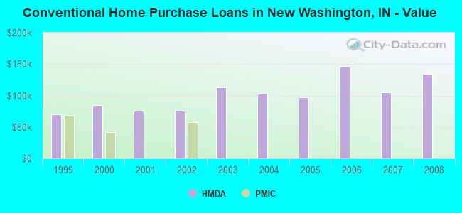
LOANS ORIGINATED
1
$56,630
0
$0
6
$109,250
1
$30,620
1
$39,900
1
$49,890
APPLICATIONS APPROVED, NOT ACCEPTED
0
$0
0
$0
1
$69,760
0
$0
0
$0
0
$0
APPLICATIONS DENIED
0
$0
1
$49,790
2
$142,365
0
$0
0
$0
0
$0
APPLICATIONS WITHDRAWN
0
$0
0
$0
1
$132,230
0
$0
0
$0
0
$0
FILES CLOSED FOR INCOMPLETENESS
0
$0
0
$0
0
$0
0
$0
0
$0
0
$0
Aggregated Statistics For Year 2008 (Based on 1 partial tract)
A) FHA, FSA/RHS & VA Home Purchase Loans
B) Conventional Home Purchase Loans
C) Refinancings
D) Home Improvement Loans
F) Non-occupant Loans on < 5 Family Dwellings (A B C & D)
G) Loans On Manufactured Home Dwelling (A B C & D)
Number
Average Value
Number
Average Value
Number
Average Value
Number
Average Value
Number
Average Value
Number
Average Value
LOANS ORIGINATED
1
$82,240
1
$134,810
4
$100,082
1
$11,860
1
$63,020
1
$54,100
APPLICATIONS APPROVED, NOT ACCEPTED
0
$0
0
$0
0
$0
0
$0
0
$0
0
$0
APPLICATIONS DENIED
0
$0
0
$0
3
$139,697
1
$39,500
0
$0
1
$46,750
APPLICATIONS WITHDRAWN
0
$0
0
$0
1
$65,610
0
$0
0
$0
0
$0
FILES CLOSED FOR INCOMPLETENESS
0
$0
0
$0
0
$0
0
$0
0
$0
0
$0
Aggregated Statistics For Year 2007 (Based on 1 partial tract)
B) Conventional Home Purchase Loans
C) Refinancings
D) Home Improvement Loans
F) Non-occupant Loans on < 5 Family Dwellings (A B C & D)
G) Loans On Manufactured Home Dwelling (A B C & D)
Number
Average Value
Number
Average Value
Number
Average Value
Number
Average Value
Number
Average Value
LOANS ORIGINATED
2
$104,545
5
$121,558
1
$35,790
1
$41,470
1
$99,270
APPLICATIONS APPROVED, NOT ACCEPTED
0
$0
1
$112,500
0
$0
0
$0
0
$0
APPLICATIONS DENIED
1
$86,040
3
$132,140
1
$47,860
0
$0
1
$56,120
APPLICATIONS WITHDRAWN
0
$0
1
$165,990
0
$0
0
$0
0
$0
FILES CLOSED FOR INCOMPLETENESS
0
$0
1
$96,740
0
$0
0
$0
0
$0
Aggregated Statistics For Year 2006 (Based on 1 partial tract)
A) FHA, FSA/RHS & VA Home Purchase Loans
B) Conventional Home Purchase Loans
C) Refinancings
D) Home Improvement Loans
F) Non-occupant Loans on < 5 Family Dwellings (A B C & D)
G) Loans On Manufactured Home Dwelling (A B C & D)
Number
Average Value
Number
Average Value
Number
Average Value
Number
Average Value
Number
Average Value
Number
Average Value
LOANS ORIGINATED
1
$64,850
2
$145,205
5
$91,808
1
$40,360
1
$117,730
2
$55,135
APPLICATIONS APPROVED, NOT ACCEPTED
0
$0
0
$0
1
$71,440
0
$0
0
$0
0
$0
APPLICATIONS DENIED
0
$0
1
$97,800
4
$99,752
0
$0
0
$0
1
$114,580
APPLICATIONS WITHDRAWN
0
$0
0
$0
1
$182,720
0
$0
0
$0
0
$0
FILES CLOSED FOR INCOMPLETENESS
0
$0
0
$0
1
$125,530
0
$0
0
$0
0
$0
Aggregated Statistics For Year 2005 (Based on 1 partial tract)
A) FHA, FSA/RHS & VA Home Purchase Loans
B) Conventional Home Purchase Loans
C) Refinancings
D) Home Improvement Loans
F) Non-occupant Loans on < 5 Family Dwellings (A B C & D)
G) Loans On Manufactured Home Dwelling (A B C & D)
Number
Average Value
Number
Average Value
Number
Average Value
Number
Average Value
Number
Average Value
Number
Average Value
LOANS ORIGINATED
1
$84,310
3
$97,430
6
$94,808
1
$81,830
1
$52,120
2
$79,170
APPLICATIONS APPROVED, NOT ACCEPTED
0
$0
0
$0
1
$144,190
0
$0
0
$0
0
$0
APPLICATIONS DENIED
0
$0
1
$98,310
6
$101,383
1
$40,100
0
$0
2
$69,155
APPLICATIONS WITHDRAWN
0
$0
0
$0
3
$101,063
0
$0
0
$0
1
$51,210
FILES CLOSED FOR INCOMPLETENESS
0
$0
0
$0
2
$99,015
0
$0
0
$0
0
$0
Aggregated Statistics For Year 2004 (Based on 1 partial tract)
A) FHA, FSA/RHS & VA Home Purchase Loans
B) Conventional Home Purchase Loans
C) Refinancings
D) Home Improvement Loans
F) Non-occupant Loans on < 5 Family Dwellings (A B C & D)
G) Loans On Manufactured Home Dwelling (A B C & D)
Number
Average Value
Number
Average Value
Number
Average Value
Number
Average Value
Number
Average Value
Number
Average Value
LOANS ORIGINATED
1
$81,930
3
$102,600
8
$91,741
1
$44,720
1
$99,420
2
$55,770
APPLICATIONS APPROVED, NOT ACCEPTED
0
$0
0
$0
2
$84,465
0
$0
0
$0
1
$45,380
APPLICATIONS DENIED
0
$0
1
$132,880
5
$130,430
1
$41,730
0
$0
1
$91,410
APPLICATIONS WITHDRAWN
0
$0
0
$0
2
$124,065
0
$0
0
$0
0
$0
FILES CLOSED FOR INCOMPLETENESS
0
$0
0
$0
1
$118,380
0
$0
0
$0
0
$0
Aggregated Statistics For Year 2003 (Based on 1 partial tract)
B) Conventional Home Purchase Loans
C) Refinancings
D) Home Improvement Loans
F) Non-occupant Loans on < 5 Family Dwellings (A B C & D)
Number
Average Value
Number
Average Value
Number
Average Value
Number
Average Value
LOANS ORIGINATED
2
$112,630
15
$92,595
1
$39,500
1
$33,010
APPLICATIONS APPROVED, NOT ACCEPTED
0
$0
2
$74,225
0
$0
0
$0
APPLICATIONS DENIED
1
$63,020
5
$99,828
0
$0
0
$0
APPLICATIONS WITHDRAWN
0
$0
3
$90,043
0
$0
0
$0
FILES CLOSED FOR INCOMPLETENESS
0
$0
1
$51,760
0
$0
0
$0
Aggregated Statistics For Year 2002 (Based on 1 partial tract)
B) Conventional Home Purchase Loans
C) Refinancings
D) Home Improvement Loans
F) Non-occupant Loans on < 5 Family Dwellings (A B C & D)
Number
Average Value
Number
Average Value
Number
Average Value
Number
Average Value
LOANS ORIGINATED
3
$76,133
11
$90,574
1
$17,440
1
$78,990
APPLICATIONS APPROVED, NOT ACCEPTED
0
$0
3
$71,403
0
$0
0
$0
APPLICATIONS DENIED
1
$60,990
4
$76,405
0
$0
0
$0
APPLICATIONS WITHDRAWN
0
$0
2
$80,030
0
$0
0
$0
FILES CLOSED FOR INCOMPLETENESS
0
$0
1
$97,950
0
$0
0
$0
Aggregated Statistics For Year 2001 (Based on 1 partial tract)
A) FHA, FSA/RHS & VA Home Purchase Loans
B) Conventional Home Purchase Loans
C) Refinancings
D) Home Improvement Loans
F) Non-occupant Loans on < 5 Family Dwellings (A B C & D)
Number
Average Value
Number
Average Value
Number
Average Value
Number
Average Value
Number
Average Value
LOANS ORIGINATED
1
$60,230
2
$75,570
8
$83,655
2
$20,180
1
$24,390
APPLICATIONS APPROVED, NOT ACCEPTED
0
$0
1
$29,610
1
$91,410
0
$0
0
$0
APPLICATIONS DENIED
0
$0
1
$91,920
4
$74,275
0
$0
0
$0
APPLICATIONS WITHDRAWN
0
$0
0
$0
2
$75,060
0
$0
0
$0
FILES CLOSED FOR INCOMPLETENESS
0
$0
0
$0
1
$48,010
0
$0
0
$0
Aggregated Statistics For Year 2000 (Based on 1 partial tract)
B) Conventional Home Purchase Loans
C) Refinancings
D) Home Improvement Loans
F) Non-occupant Loans on < 5 Family Dwellings (A B C & D)
Number
Average Value
Number
Average Value
Number
Average Value
Number
Average Value
LOANS ORIGINATED
3
$84,483
6
$73,347
2
$12,675
1
$37,520
APPLICATIONS APPROVED, NOT ACCEPTED
1
$36,710
1
$65,350
0
$0
0
$0
APPLICATIONS DENIED
3
$60,267
3
$55,887
1
$29,050
0
$0
APPLICATIONS WITHDRAWN
0
$0
2
$64,340
0
$0
0
$0
FILES CLOSED FOR INCOMPLETENESS
0
$0
0
$0
0
$0
0
$0
Aggregated Statistics For Year 1999 (Based on 1 partial tract)
B) Conventional Home Purchase Loans
C) Refinancings
D) Home Improvement Loans
F) Non-occupant Loans on < 5 Family Dwellings (A B C & D)


 Recent articles from our blog. Our writers, many of them Ph.D. graduates or candidates, create easy-to-read articles on a wide variety of topics.

 (25.7 miles