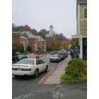
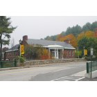
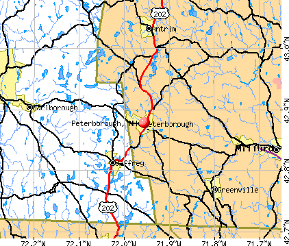
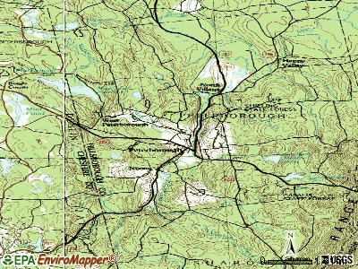
Peterborough, New Hampshire
Submit your own pictures of this place and show them to the world
- OSM Map
- General Map
- Google Map
- MSN Map
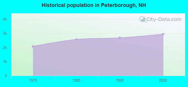
Population change since 2000: +5.4%
| Males: 1,402 | |
| Females: 1,701 |
| Median resident age: | 60.3 years |
| New Hampshire median age: | 43.3 years |
Zip codes: 03458.
| Peterborough: | $85,502 |
| NH: | $89,992 |
Estimated per capita income in 2022: $73,015 (it was $26,091 in 2000)
Peterborough CDP income, earnings, and wages data
Estimated median house or condo value in 2022: $338,744 (it was $120,600 in 2000)
| Peterborough: | $338,744 |
| NH: | $384,700 |
Mean prices in 2022: all housing units: $411,252; detached houses: $441,251; townhouses or other attached units: $283,002; in 2-unit structures: $347,377; in 3-to-4-unit structures: $666,663; in 5-or-more-unit structures: $275,798; mobile homes: $132,093
Median gross rent in 2022: $1,432.
Detailed information about poverty and poor residents in Peterborough, NH


Compare current foreclosures near Peterborough, NH:
| Photo | Address | Area | Beds / Baths | Price | Details |
|---|---|---|---|---|---|

|
#1
Nashua St
Milford, NH 03055
|
2,172 sq. feet
|
2 baths 4 beds |
show details | |

|
#2
Lakeshore Dr
Ashburnham, MA 01430
|
- sq. feet
|
- baths - beds |
$5,000
|
show details |

|
#3
Amherst St
Amherst, NH 03031
|
- sq. feet
|
4 baths 3 beds |
show details | |

|
#4
W Hill Rd
Troy, NH 03465
|
1,664 sq. feet
|
2 baths 3 beds |
show details | |

|
#5
South St
Troy, NH 03465
|
1,476 sq. feet
|
1 baths 3 beds |
show details | |

|
#6
Rindge State Rd
Ashburnham, MA 01430
|
1,260 sq. feet
|
1 baths 3 beds |
show details | |

|
#7
Maple St
Winchendon, MA 01475
|
1,000 sq. feet
|
1 baths 2 beds |
show details | |

|
#8
Rindge State Rd
Ashburnham, MA 01430
|
1,200 sq. feet
|
1 baths 3 beds |
show details | |

|
#9
Noel Dr
Ashburnham, MA 01430
|
960 sq. feet
|
1 baths 3 beds |
show details | |

|
#10
Turnpike Road A/k/a 137 Turpike Road
Ashby, MA Array
|
960 sq. feet
|
1 baths 2 beds |
show details |
| Photo | Address | Area | Beds / Baths | Price | Details |
|---|---|---|---|---|---|

|
#11
Central St
Winchendon, MA 01475
|
1,685 sq. feet
|
1 baths 3 beds |
show details | |

|
#12
South Rd
Swanzey, NH 03446
|
3,841 sq. feet
|
3 baths 3 beds |
show details | |

|
#13
Royalston Rd S
Winchendon, MA 01475
|
1,188 sq. feet
|
2 baths 3 beds |
show details | |

|
#14
West St
Winchendon, MA 01475
|
1,584 sq. feet
|
1 baths 3 beds |
show details | |

|
#15
School St
Winchendon, MA 01475
|
1,518 sq. feet
|
1 baths 3 beds |
show details | |

|
#16
Hale Hill Rd
Swanzey, NH 03446
|
2,976 sq. feet
|
2 baths 3 beds |
show details | |

|
#17
Juniper St
Winchendon, MA 01475
|
1,687 sq. feet
|
1 baths 4 beds |
show details | |

|
#18
Hill St
Winchendon, MA 01475
|
1,549 sq. feet
|
1 baths 3 beds |
show details | |

|
#19
Spruce St
Winchendon, MA 01475
|
1,504 sq. feet
|
1 baths 3 beds |
show details | |

|
#20
Cushing St
Ashburnham, MA 01430
|
1,445 sq. feet
|
1 baths 3 beds |
show details |
| Photo | Address | Area | Beds / Baths | Price | Details |
|---|---|---|---|---|---|

|
#21
Maple St
Winchendon, MA 01475
|
903 sq. feet
|
1 baths 2 beds |
show details | |

|
#22
Cypress Rd
Milford, NH 03055
|
1,929 sq. feet
|
1 baths 3 beds |
show details | |

|
#23
Malderelli Rd
Greenville, NH 03048
|
1,098 sq. feet
|
1 baths 3 beds |
show details | |

|
#24
Old New Ipswich Rd
Rindge, NH 03461
|
1,184 sq. feet
|
2 baths 3 beds |
show details | |

|
#25
Fitzgerald Rd
Rindge, NH 03461
|
3,960 sq. feet
|
3 baths 4 beds |
show details | |

|
#26
Birch Dr
Rindge, NH 03461
|
1,971 sq. feet
|
2 baths 4 beds |
show details | |

|
#27
Sibley Rd
Winchendon, MA 01475
|
1,728 sq. feet
|
2 baths 3 beds |
show details | |

|
#28
Teel Rd
Winchendon, MA 01475
|
1,080 sq. feet
|
1 baths 3 beds |
show details | |

|
#29
Turnpike Rd
Ashby, MA 01431
|
960 sq. feet
|
1 baths 2 beds |
show details | |

|
#30
Lord Brook Rd
Rindge, NH 03461
|
1,920 sq. feet
|
1 baths 3 beds |
show details |
| Photo | Address | Area | Beds / Baths | Price | Details |
|---|---|---|---|---|---|

|
#31
Taggart Cir
Rindge, NH 03461
|
1,488 sq. feet
|
1 baths 3 beds |
show details | |

|
#32
Ash St
Winchendon, MA 01475
|
960 sq. feet
|
1 baths 2 beds |
show details | |

|
#33
Converse Dr
Winchendon, MA 01475
|
2,108 sq. feet
|
1 baths 3 beds |
show details | |

|
#34
Courthouse Rd
Amherst, NH 03031
|
1,391 sq. feet
|
1 baths 3 beds |
show details | |

|
#35
Osgood Rd
Milford, NH 03055
|
1,349 sq. feet
|
1 baths 3 beds |
show details | |

|
#36
Converse Dr
Winchendon, MA 01475
|
2,120 sq. feet
|
3 baths 3 beds |
show details | |

|
#37
Turnpike Rd
Ashby, MA 01431
|
960 sq. feet
|
1 baths 2 beds |
show details | |

|
#38
Marlboro Rd
Keene, NH 03431
|
908 sq. feet
|
1 baths 3 beds |
show details | |

|
#39
Mill St
New Boston, NH 03070
|
- sq. feet
|
3 baths 4 beds |
show details | |

|
#40
Howard St # 2
Keene, NH 03431
|
- sq. feet
|
2 baths 3 beds |
show details |
| Photo | Address | Area | Beds / Baths | Price | Details |
|---|---|---|---|---|---|

|
#41
Curtis Farm Rd
Wilton, NH 03086
|
- sq. feet
|
1 baths 3 beds |
show details | |

|
#42
Washington St
Keene, NH 03431
|
- sq. feet
|
1 baths 3 beds |
show details | |

|
#43
Washington St
Keene, NH 03431
|
- sq. feet
|
1 baths 3 beds |
show details | |

|
#44
Dale St
Wilton, NH 03086
|
- sq. feet
|
2 baths 3 beds |
show details | |

|
#45
Francestown Rd
Bennington, NH 03442
|
- sq. feet
|
1 baths 2 beds |
show details | |

|
#46
Powers St Apt 135
Milford, NH 03055
|
- sq. feet
|
- baths - beds |
show details | |

|
#47
Powers St Apt 119
Milford, NH 03055
|
- sq. feet
|
- baths - beds |
show details | |

|
#48
Fitzwilliam Rd
Winchester, NH 03470
|
- sq. feet
|
- baths - beds |
show details | |

|
#49
Childs Way
Hillsboro, NH 03244
|
- sq. feet
|
- baths - beds |
show details | |

|
Check over 1 million property listings on Foreclosure.com!
|
browse all offers | |||


- 2,00588.4%White alone
- 1717.5%Hispanic
- 311.4%Asian alone
- 120.5%Two or more races
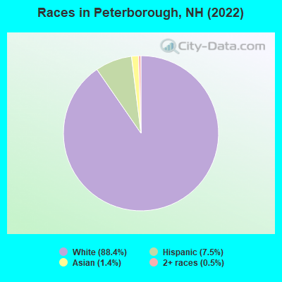
Races in Peterborough detailed stats: ancestries, foreign born residents, place of birth
According to our research of New Hampshire and other state lists, there were 12 registered sex offenders living in Peterborough, New Hampshire as of April 24, 2024.
The ratio of all residents to sex offenders in Peterborough is 253 to 1.
Type |
2009 |
2010 |
2011 |
2012 |
2013 |
2014 |
2015 |
2016 |
2017 |
2018 |
2019 |
2020 |
2021 |
2022 |
|---|---|---|---|---|---|---|---|---|---|---|---|---|---|---|
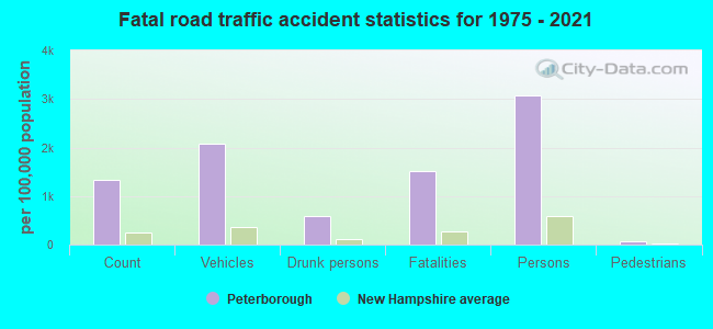
| Murders (per 100,000) | 1 (16.1) | 0 (0.0) | 0 (0.0) | 0 (0.0) | 0 (0.0) | 0 (0.0) | 0 (0.0) | 0 (0.0) | 0 (0.0) | 0 (0.0) | 0 (0.0) | 0 (0.0) | 0 (0.0) | 0 (0.0) |
| Rapes (per 100,000) | 0 (0.0) | 2 (31.8) | 3 (47.7) | 0 (0.0) | 2 (31.3) | 3 (46.6) | 2 (30.7) | 3 (46.4) | 3 (45.7) | 2 (30.6) | 4 (60.0) | 5 (74.2) | 5 (73.6) | 1 (15.4) |
| Robberies (per 100,000) | 1 (16.1) | 2 (31.8) | 0 (0.0) | 0 (0.0) | 1 (15.7) | 0 (0.0) | 0 (0.0) | 0 (0.0) | 1 (15.2) | 0 (0.0) | 1 (15.0) | 0 (0.0) | 0 (0.0) | 1 (15.4) |
| Assaults (per 100,000) | 3 (48.2) | 1 (15.9) | 0 (0.0) | 6 (95.1) | 3 (47.0) | 7 (108.7) | 3 (46.0) | 4 (61.8) | 7 (106.6) | 3 (45.9) | 6 (90.0) | 2 (29.7) | 3 (44.2) | 3 (46.3) |
| Burglaries (per 100,000) | 26 (418.1) | 8 (127.3) | 24 (381.4) | 20 (317.0) | 21 (329.0) | 10 (155.2) | 19 (291.3) | 7 (108.2) | 12 (182.7) | 9 (137.7) | 4 (60.0) | 8 (118.8) | 3 (44.2) | 3 (46.3) |
| Thefts (per 100,000) | 97 (1,560) | 108 (1,719) | 88 (1,399) | 91 (1,442) | 84 (1,316) | 54 (838.2) | 48 (736.0) | 45 (695.6) | 44 (669.9) | 62 (948.6) | 42 (629.8) | 56 (831.4) | 50 (736.2) | 23 (355.0) |
| Auto thefts (per 100,000) | 3 (48.2) | 2 (31.8) | 4 (63.6) | 3 (47.5) | 4 (62.7) | 0 (0.0) | 0 (0.0) | 5 (77.3) | 3 (45.7) | 5 (76.5) | 2 (30.0) | 6 (89.1) | 6 (88.3) | 1 (15.4) |
| Arson (per 100,000) | 1 (16.1) | 0 (0.0) | 0 (0.0) | 2 (31.7) | 4 (62.7) | 0 (0.0) | 0 (0.0) | 1 (15.5) | 0 (0.0) | 0 (0.0) | 0 (0.0) | 0 (0.0) | 0 (0.0) | 1 (15.4) |
| City-Data.com crime index | 142.2 | 118.4 | 125.9 | 102.7 | 119.8 | 103.4 | 83.6 | 91.0 | 105.7 | 87.4 | 102.3 | 114.0 | 107.3 | 44.9 |
The City-Data.com crime index weighs serious crimes and violent crimes more heavily. Higher means more crime, U.S. average is 246.1. It adjusts for the number of visitors and daily workers commuting into cities.
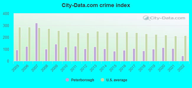
Crime rate in Peterborough detailed stats: murders, rapes, robberies, assaults, burglaries, thefts, arson
Full-time law enforcement employees in 2021, including police officers: 14 (12 officers - 12 male; 0 female).
| Officers per 1,000 residents here: | 1.77 |
| New Hampshire average: | 2.14 |
 Recent articles from our blog. Our writers, many of them Ph.D. graduates or candidates, create easy-to-read articles on a wide variety of topics.

 | Online Thieves Steal $2.3 Million from Peterborough (35 replies) |
| Moving to Peterborough..from Kauai (42 replies) |
| Moving to Peterborough/Tell Me What I Need to Know! (2 replies) |
| Traffic Between Peterborough and Nashua on 101 (1 reply) |
| Considering a move to Peterborough, NH (12 replies) |
| Shed mover - Peterborough area - looking for recommendation (5 replies) |
Latest news from Peterborough, NH collected exclusively by city-data.com from local newspapers, TV, and radio stations
Ancestries: English (26.3%), Irish (23.2%), Italian (12.0%), American (6.5%), French Canadian (3.1%), Dutch (2.6%).
Current Local Time: EST time zone
Incorporated in 1760
Elevation: 723 feet
Land area: 4.74 square miles.
Population density: 655 people per square mile (low).
127 residents are foreign born (4.1% Latin America, 0.8% Asia).
| This place: | 5.6% |
| New Hampshire: | 6.0% |
Median real estate property taxes paid for housing units with mortgages in 2022: $6,759 (2.2%)
Median real estate property taxes paid for housing units with no mortgage in 2022: $8,221 (2.1%)
Nearest city with pop. 50,000+: Nashua, NH  (25.6 miles , pop. 86,605).
Nearest city with pop. 200,000+: Boston, MA (58.5 miles , pop. 589,141).
Nearest city with pop. 1,000,000+: Bronx, NY (171.8 miles , pop. 1,332,650).
Nearest cities:
), ), ), )Latitude: 42.88 N, Longitude: 71.95 W
Daytime population change due to commuting: +1,385 (+61.1%)
Workers who live and work in this place: 504 (37.7%)
Area code: 603
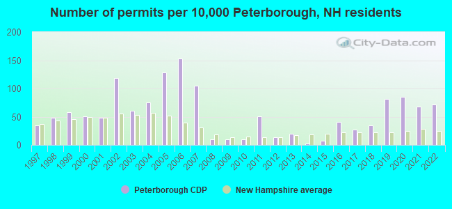
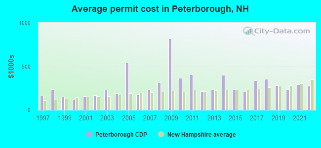
Single-family new house construction building permits:
- 2022: 21 buildings, average cost: $278,600
- 2021: 20 buildings, average cost: $294,800
- 2020: 25 buildings, average cost: $238,200
- 2019: 24 buildings, average cost: $280,500
- 2018: 10 buildings, average cost: $357,000
- 2017: 8 buildings, average cost: $336,900
- 2016: 12 buildings, average cost: $206,500
- 2015: 2 buildings, average cost: $235,000
- 2014: 1 building, cost: $400,000
- 2013: 6 buildings, average cost: $228,800
- 2012: 4 buildings, average cost: $212,500
- 2011: 15 buildings, average cost: $405,300
- 2010: 3 buildings, average cost: $366,700
- 2009: 3 buildings, average cost: $821,000
- 2008: 3 buildings, average cost: $315,000
- 2007: 31 buildings, average cost: $238,400
- 2006: 45 buildings, average cost: $180,300
- 2005: 38 buildings, average cost: $546,700
- 2004: 22 buildings, average cost: $192,300
- 2003: 18 buildings, average cost: $234,300
- 2002: 35 buildings, average cost: $166,800
- 2001: 14 buildings, average cost: $160,900
- 2000: 15 buildings, average cost: $120,500
- 1999: 17 buildings, average cost: $151,800
- 1998: 14 buildings, average cost: $235,600
- 1997: 10 buildings, average cost: $165,000
| Here: | 2.6% |
| New Hampshire: | 2.5% |
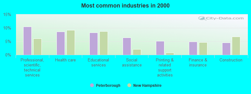
- Professional, scientific, technical services (10.5%)
- Health care (8.6%)
- Educational services (8.3%)
- Social assistance (6.4%)
- Printing & related support activities (5.1%)
- Finance & insurance (4.9%)
- Construction (4.5%)
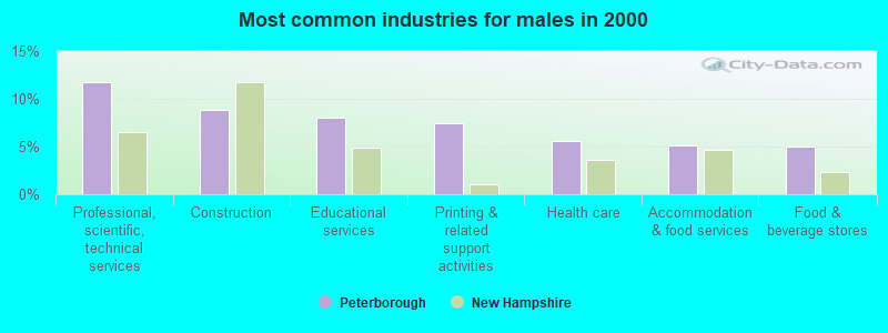
- Professional, scientific, technical services (11.7%)
- Construction (8.9%)
- Educational services (8.0%)
- Printing & related support activities (7.4%)
- Health care (5.6%)
- Accommodation & food services (5.1%)
- Food & beverage stores (5.0%)
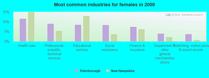
- Health care (11.7%)
- Professional, scientific, technical services (9.2%)
- Educational services (8.6%)
- Social assistance (8.4%)
- Finance & insurance (7.6%)
- Department & other general merchandise stores (4.1%)
- Publishing, motion picture & sound recording industries (3.9%)

- Other management occupations, except farmers and farm managers (7.7%)
- Other production occupations, including supervisors (6.3%)
- Other sales and related occupations, including supervisors (4.7%)
- Retail sales workers, except cashiers (4.7%)
- Other office and administrative support workers, including supervisors (4.6%)
- Preschool, kindergarten, elementary, and middle school teachers (4.4%)
- Material recording, scheduling, dispatching, and distributing workers (3.5%)

- Other management occupations, except farmers and farm managers (9.6%)
- Other production occupations, including supervisors (9.6%)
- Top executives (5.9%)
- Other sales and related occupations, including supervisors (4.7%)
- Retail sales workers, except cashiers (4.1%)
- Computer specialists (3.9%)
- Cooks and food preparation workers (3.4%)
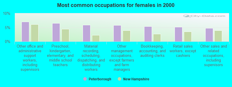
- Other office and administrative support workers, including supervisors (7.0%)
- Preschool, kindergarten, elementary, and middle school teachers (6.5%)
- Material recording, scheduling, dispatching, and distributing workers (5.9%)
- Other management occupations, except farmers and farm managers (5.8%)
- Bookkeeping, accounting, and auditing clerks (5.3%)
- Retail sales workers, except cashiers (5.2%)
- Other sales and related occupations, including supervisors (4.7%)
Average climate in Peterborough, New Hampshire
Based on data reported by over 4,000 weather stations


|
|

(lower is better)
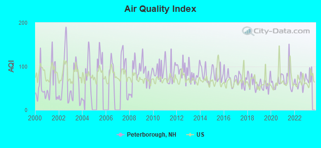
Air Quality Index (AQI) level in 2022 was 64.4. This is about average.
| City: | 64.4 |
| U.S.: | 72.6 |
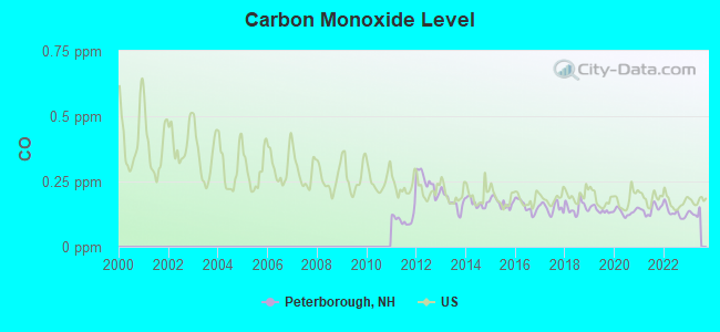
Carbon Monoxide (CO) [ppm] level in 2022 was 0.131. This is significantly better than average. Closest monitor was 3.6 miles away from the city center.
| City: | 0.131 |
| U.S.: | 0.251 |
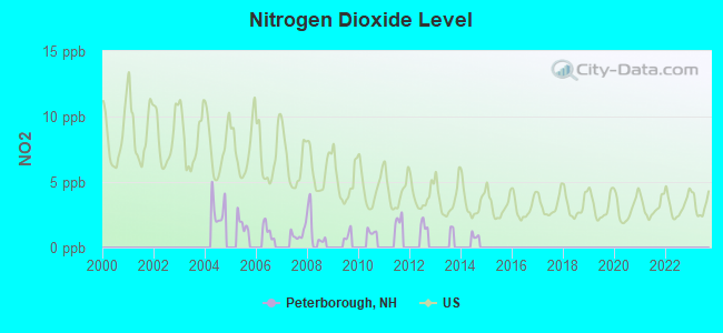
Nitrogen Dioxide (NO2) [ppb] level in 2008 was 1.47. This is significantly better than average. Closest monitor was 4.0 miles away from the city center.
| City: | 1.47 |
| U.S.: | 5.11 |
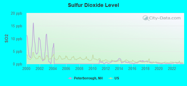
Sulfur Dioxide (SO2) [ppb] level in 2022 was 0.411. This is significantly better than average. Closest monitor was 3.6 miles away from the city center.
| City: | 0.411 |
| U.S.: | 1.515 |
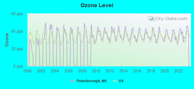
Ozone [ppb] level in 2022 was 36.6. This is about average. Closest monitor was 4.0 miles away from the city center.
| City: | 36.6 |
| U.S.: | 33.3 |
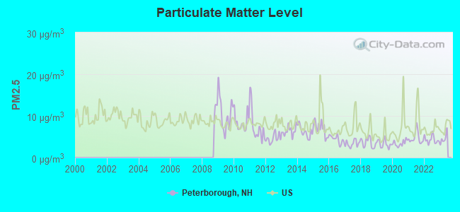
Particulate Matter (PM2.5) [µg/m3] level in 2022 was 4.29. This is significantly better than average. Closest monitor was 4.0 miles away from the city center.
| City: | 4.29 |
| U.S.: | 8.11 |
Tornado activity:
Peterborough-area historical tornado activity is above New Hampshire state average. It is 26% smaller than the overall U.S. average.
On 6/9/1953, a category F4 (max. wind speeds 207-260 mph) tornado 30.3 miles away from the Peterborough place center killed 90 people and injured 1228 people and caused between $50,000,000 and $500,000,000 in damages.
On 6/22/1981, a category F3 (max. wind speeds 158-206 mph) tornado 22.9 miles away from the place center injured 3 people and caused between $5000 and $50,000 in damages.
Earthquake activity:
Peterborough-area historical earthquake activity is significantly above New Hampshire state average. It is 71% smaller than the overall U.S. average.On 10/7/1983 at 10:18:46, a magnitude 5.3 (5.1 MB, 5.3 LG, 5.1 ML, Class: Moderate, Intensity: VI - VII) earthquake occurred 141.1 miles away from Peterborough center
On 4/20/2002 at 10:50:47, a magnitude 5.3 (5.3 ML, Depth: 3.0 mi) earthquake occurred 142.7 miles away from Peterborough center
On 4/20/2002 at 10:50:47, a magnitude 5.2 (5.2 MB, 4.2 MS, 5.2 MW, 5.0 MW) earthquake occurred 142.0 miles away from the city center
On 1/19/1982 at 00:14:42, a magnitude 4.7 (4.5 MB, 4.7 MD, 4.5 LG, Class: Light, Intensity: IV - V) earthquake occurred 46.6 miles away from the city center
On 10/16/2012 at 23:12:25, a magnitude 4.7 (4.7 ML, Depth: 10.0 mi) earthquake occurred 82.2 miles away from the city center
On 10/2/1994 at 11:27:22, a magnitude 3.7 (3.5 LG, 3.7 LG, Depth: 6.2 mi, Class: Light, Intensity: II - III) earthquake occurred 40.2 miles away from the city center
Magnitude types: regional Lg-wave magnitude (LG), body-wave magnitude (MB), duration magnitude (MD), local magnitude (ML), surface-wave magnitude (MS), moment magnitude (MW)
Natural disasters:
The number of natural disasters in Hillsborough County (27) is a lot greater than the US average (15).Major Disasters (Presidential) Declared: 17
Emergencies Declared: 10
Causes of natural disasters: Storms: 13, Floods: 11, Winter Storms: 5, Snowstorms: 4, Hurricanes: 3, Snows: 3, Blizzard: 1, Ice Storm: 1, Snowfall: 1, Wind: 1 (Note: some incidents may be assigned to more than one category).
Hospitals and medical centers in Peterborough:
- MONADNOCK COMMUNITY HOSPITAL (Proprietary, 452 OLD STREET ROAD)
- PHEASANT WOOD CARE AND REHABILIATION CENTER (50 PHEASANT ROAD)
Other hospitals and medical centers near Peterborough:
- GOOD SHEPHERD REHABILITATION AND NURSING CENTER (Nursing Home, about 6 miles away; JAFFREY, NH)
- OPEN ARMS NURSING HOME INC (Nursing Home, about 15 miles away; WINCHENDON, MA)
- NAUKEAG HOSPITAL CORPORATION (Hospital, about 15 miles away; ASHBURNHAM, MA)
- CRESTWOOD CARE AND REHABILITATION CENTER (Nursing Home, about 16 miles away; MILFORD, NH)
- ST JOSEPH HOME AND HOSPICE CARE (Home Health Center, about 16 miles away; MILFORD, NH)
- WACHUSETT MANOR NURSING HOME (Nursing Home, about 16 miles away; GARDNER, MA)
- ELM'S NURSING AND REHAB CENTER (THE) (Nursing Home, about 16 miles away; MILFORD, NH)
Heliports located in Peterborough:
Colleges/universities with over 2000 students nearest to Peterborough:
- Franklin Pierce University (about 9 miles; Rindge, NH; Full-time enrollment: 2,139)
- Keene State College (about 17 miles; Keene, NH; FT enrollment: 5,098)
- Mount Wachusett Community College (about 20 miles; Gardner, MA; FT enrollment: 3,143)
- Fitchburg State University (about 22 miles; Fitchburg, MA; FT enrollment: 5,010)
- Saint Anselm College (about 24 miles; Manchester, NH; FT enrollment: 2,059)
- Mount Washington College (about 26 miles; Manchester, NH; FT enrollment: 2,187)
- Southern New Hampshire University (about 28 miles; Manchester, NH; FT enrollment: 16,552)
Public high school in Peterborough:
- CONVAL REGIONAL HIGH SCHOOL (Students: 1,154, Location: 184 HANCOCK RD., Grades: 9-12)
Public elementary/middle schools in Peterborough:
- SOUTH MEADOW SCHOOL (Students: 520, Location: 108 HANCOCK RD., Grades: 5-8)
- PETERBOROUGH ELEMENTARY SCHOOL (Students: 374, Location: 17 HIGH ST., Grades: PK-4)
Private elementary/middle school in Peterborough:
- THE WELL SCHOOL (Students: 141, Location: 360 MIDDLE HANCOCK RD, Grades: PK-8)
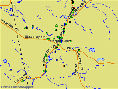
Points of interest:
Notable locations in Peterborough: Monadnock Country Club (A), Peterborough Town Library (B), Peterborough Town Hall (C), Peterborough Historical Society Library (D), Peterborough Historical Society Building (E), Thomas H Eckfeldt Memorial Medical Library (F), Greater Peterborough Chamber of Commerce (G), Peterborough Fire and Rescue (H). Display/hide their locations on the map
Shopping Center: Petersborough Shopping Plaza Shopping Center (1). Display/hide its location on the map
Churches in Peterborough include: Petersborough Unitarian Church (A), First Church of Christ Scientist (B), All Saints Episcopal Church (C). Display/hide their locations on the map
Cemeteries: East Hill Cemetery (1), Pine Hill Cemetery (2), Village Cemetery (3), Saint Peters Cemetery (4). Display/hide their locations on the map
Reservoir: Contoocook River Reservoir (A). Display/hide its location on the map
Streams, rivers, and creeks: Nubanusit Brook (A). Display/hide its location on the map
Park in Peterborough: The Common (1). Display/hide its location on the map
Tourist attraction: Mariposa Museum (26 Main Street).
Hotel: Jack Daniels Motor Inn (80 Concord Street).
Birthplace of: Matt Deis - Musician, Sam Huntington - Child actor, Jeremiah Smith (lawyer) - Federal judge, James Miller (general) - Politician, Moses Warren - Politician.
Drinking water stations with addresses in Peterborough and their reported violations in the past:
PETERBOROUGH WATER WORKS (Address: 1 GROVE ST , Population served: 4,062, Groundwater):Past health violations:Past monitoring violations:
- MCL, Monthly (TCR) - In JUL-2012, Contaminant: Coliform. Follow-up actions: St Public Notif requested (JUL-24-2012), St Violation/Reminder Notice (JUL-24-2012), St Public Notif received (AUG-21-2012), St Compliance achieved (JAN-18-2013)
- MCL, Monthly (TCR) - In OCT-2009, Contaminant: Coliform. Follow-up actions: St Public Notif requested (OCT-22-2009), St Violation/Reminder Notice (OCT-22-2009), St Public Notif received (OCT-30-2009), St Compliance achieved (MAY-25-2010)
- MCL, Monthly (TCR) - In OCT-2007, Contaminant: Coliform. Follow-up actions: St Public Notif requested (OCT-16-2007), St Violation/Reminder Notice (OCT-16-2007), St Public Notif received (DEC-13-2007), St Compliance achieved (MAY-07-2008)
- MCL, Monthly (TCR) - In SEP-2006, Contaminant: Coliform. Follow-up actions: St Public Notif requested (SEP-12-2006), St Violation/Reminder Notice (SEP-12-2006), St Public Notif received (NOV-22-2006), St Compliance achieved (MAR-30-2007)
- MCL, Monthly (TCR) - In DEC-2005, Contaminant: Coliform. Follow-up actions: St Public Notif requested (DEC-23-2005), St Violation/Reminder Notice (DEC-23-2005), St Public Notif received (DEC-29-2005), St Compliance achieved (JUN-30-2006)
- MCL, Acute (TCR) - In AUG-2005, Contaminant: Coliform. Follow-up actions: St Public Notif requested (AUG-11-2005), St Violation/Reminder Notice (AUG-11-2005), St Public Notif received (AUG-23-2005), St Compliance achieved (JUN-30-2006)
- 2 minor monitoring violations
| This place: | 2.1 people |
| New Hampshire: | 2.5 people |
| This place: | 52.0% |
| Whole state: | 66.3% |
| This place: | 6.6% |
| Whole state: | 8.3% |
Likely homosexual households (counted as self-reported same-sex unmarried-partner households)
- Lesbian couples: 0.5% of all households
- Gay men: 0.3% of all households
People in group quarters in Peterborough in 2010:
- 118 people in nursing facilities/skilled-nursing facilities
- 10 people in residential treatment centers for adults
- 7 people in emergency and transitional shelters (with sleeping facilities) for people experiencing homelessness
People in group quarters in Peterborough in 2000:
- 211 people in nursing homes
- 18 people in other nonhousehold living situations
- 4 people in other noninstitutional group quarters
Banks with branches in Peterborough (2011 data):
- People's United Bank: Junction Route 101 & 202 Branch at 100 Grove Street, branch established on 1974/03/04; 35 Main Street Branch at 35 Main Street, branch established on 1859/01/01. Info updated 2012/02/16: Bank assets: $27,319.3 mil, Deposits: $20,835.4 mil, headquarters in Bridgeport, CT, positive income, Commercial Lending Specialization, 374 total offices
- Lake Sunapee Bank, FSB: Peterborough Branch at 2-4 Main Street, branch established on 2005/01/29. Info updated 2011/07/21: Bank assets: $1,040.6 mil, Deposits: $808.6 mil, headquarters in Newport, NH, positive income, Mortgage Lending Specialization, 27 total offices
- Monadnock Community Bank: at 1 Jaffrey Rd, branch established on 1996/05/01. Info updated 2011/07/21: Bank assets: $82.6 mil, Deposits: $48.9 mil, local headquarters, negative income in the last year, Mortgage Lending Specialization, 1 total offices
- TD Bank, National Association: Peterborough Branch at 120 Grove Street, branch established on 1982/01/01. Info updated 2010/10/04: Bank assets: $188,912.6 mil, Deposits: $153,149.8 mil, headquarters in Wilmington, DE, positive income, 1314 total offices, Holding Company: Toronto-Dominion Bank, The
For population 15 years and over in Peterborough:
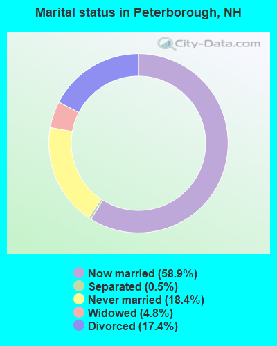
- Never married: 18.4%
- Now married: 58.9%
- Separated: 0.5%
- Widowed: 4.8%
- Divorced: 17.4%
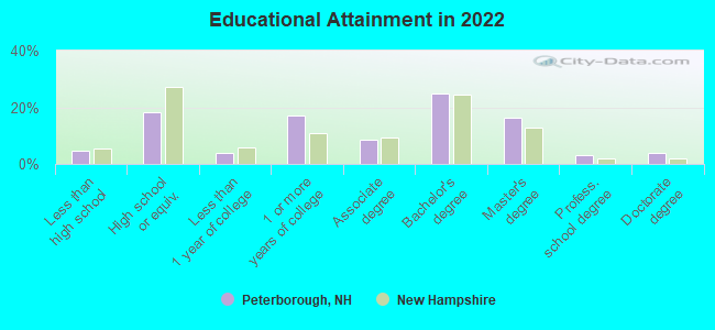
For population 25 years and over in Peterborough:
- High school or higher: 95.6%
- Bachelor's degree or higher: 47.9%
- Graduate or professional degree: 21.8%
- Unemployed: 5.6%
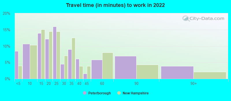
- Mean travel time to work (commute): 19.2 minutes
| Here: | 9.9 |
| New Hampshire average: | 10.3 |


Graphs represent county-level data. Detailed 2008 Election Results
Religion statistics for Peterborough, NH (based on Hillsborough County data)


| Religion | Adherents | Congregations |
|---|---|---|
| Catholic | 124,993 | 40 |
| Evangelical Protestant | 20,588 | 103 |
| Mainline Protestant | 17,794 | 60 |
| Other | 7,365 | 35 |
| Orthodox | 2,990 | 7 |
| Black Protestant | - | 1 |
| None | 226,991 | - |
Food Environment Statistics:
| This county: | 1.82 / 10,000 pop. |
| New Hampshire: | 2.14 / 10,000 pop. |
| This county: | 0.12 / 10,000 pop. |
| New Hampshire: | 0.15 / 10,000 pop. |
| Hillsborough County: | 1.65 / 10,000 pop. |
| New Hampshire: | 1.78 / 10,000 pop. |
| Hillsborough County: | 2.67 / 10,000 pop. |
| New Hampshire: | 4.02 / 10,000 pop. |
| This county: | 8.23 / 10,000 pop. |
| New Hampshire: | 9.70 / 10,000 pop. |
| Here: | 6.9% |
| New Hampshire: | 7.6% |
| This county: | 24.5% |
| New Hampshire: | 24.4% |
| Hillsborough County: | 15.1% |
| New Hampshire: | 15.9% |
Health and Nutrition:
| This city: | 55.2% |
| New Hampshire: | 51.2% |
| Peterborough: | 55.7% |
| New Hampshire: | 49.1% |
| This city: | 28.5 |
| State: | 28.5 |
| Peterborough: | 18.7% |
| State: | 20.9% |
| This city: | 11.4% |
| New Hampshire: | 9.3% |
| Here: | 7.0 |
| New Hampshire: | 6.9 |
| Peterborough: | 40.3% |
| New Hampshire: | 34.3% |
| Peterborough: | 60.2% |
| New Hampshire: | 58.1% |
| Peterborough: | 80.6% |
| New Hampshire: | 79.1% |
More about Health and Nutrition of Peterborough, NH Residents
6.73% of this county's 2021 resident taxpayers lived in other counties in 2020 ($92,767 average adjusted gross income)
| Here: | 6.73% |
| New Hampshire average: | 7.66% |
0.01% of residents moved from foreign countries ($183 average AGI)
Hillsborough County: 0.01% New Hampshire average: 0.01%
Top counties from which taxpayers relocated into this county between 2020 and 2021:
| from Middlesex County, MA | |
| from Rockingham County, NH | |
| from Merrimack County, NH |
6.49% of this county's 2020 resident taxpayers moved to other counties in 2021 ($81,100 average adjusted gross income)
| Here: | 6.49% |
| New Hampshire average: | 6.80% |
0.02% of residents moved to foreign countries ($105 average AGI)
Hillsborough County: 0.02% New Hampshire average: 0.01%
Top counties to which taxpayers relocated from this county between 2020 and 2021:
| to Rockingham County, NH | |
| to Merrimack County, NH | |
| to Middlesex County, MA |
| Businesses in Peterborough, NH | ||||
| Name | Count | Name | Count | |
|---|---|---|---|---|
| CVS | 1 | RadioShack | 1 | |
| Dunkin Donuts | 2 | Rite Aid | 1 | |
| FedEx | 2 | Shaw's | 1 | |
| H&R Block | 1 | U-Haul | 2 | |
| MasterBrand Cabinets | 2 | U.S. Cellular | 1 | |
| New Balance | 8 | UPS | 3 | |
| Nike | 1 | |||
Strongest AM radio stations in Peterborough:
- WRKO (680 AM; 50 kW; BOSTON, MA; Owner: ENTERCOM BOSTON LICENSE, LLC)
- WCRN (830 AM; 50 kW; WORCESTER, MA; Owner: CARTER BROADCASTING CORPORATION)
- WEEI (850 AM; 50 kW; BOSTON, MA; Owner: ENTERCOM BOSTON LICENSE, LLC)
- WNNZ (640 AM; 50 kW; WESTFIELD, MA; Owner: CLEAR CHANNEL BROADCASTING LICENSES, INC.)
- WKOX (1200 AM; 50 kW; FRAMINGHAM, MA; Owner: CAPSTAR TX LIMITED PARTNERSHIP)
- WVNE (760 AM; daytime; 25 kW; LEICESTER, MA; Owner: BLOUNT MASSCOM, INC.)
- WBIX (1060 AM; 40 kW; NATICK, MA; Owner: LANGER BROADCASTING CORPORATION)
- WWZN (1510 AM; 50 kW; BOSTON, MA; Owner: ROSE CITY RADIO CORPORATION)
- WKBK (1290 AM; 5 kW; KEENE, NH; Owner: SAGA COMMUNICATIONS OF NEW ENGLAND, LLC)
- WGIR (610 AM; 5 kW; MANCHESTER, NH; Owner: CAPSTAR TX LIMITED PARTNERSHIP)
- WALE (990 AM; 50 kW; GREENVILLE, RI; Owner: NORTH AMERICAN BROADCASTING CO., INC.)
- WAMG (890 AM; 25 kW; DEDHAM, MA; Owner: MEGA COMMUNICATIONS OF DEDHAM LICENSEE, LLC)
- WBZ (1030 AM; 50 kW; BOSTON, MA; Owner: INFINITY BROADCASTING OPERATIONS, INC.)
Strongest FM radio stations in Peterborough:
- W270AH (101.9 FM; PETERBOROUGH, NH; Owner: SAGA COMMUNICATIONS OF NEW ENGLAND, LLC)
- WFEX (92.1 FM; PETERBOROUGH, NH; Owner: FNX BROADCASTING OF NEW HAMPSHIRE LLC)
- WGIR-FM (101.1 FM; MANCHESTER, NH; Owner: CAPSTAR TX LIMITED PARTNERSHIP)
- WQLL (96.5 FM; BEDFORD, NH; Owner: SAGA COMMUNICATIONS OF NEW ENGLAND, LLC)
- WTPL (107.7 FM; HILLSBORO, NH; Owner: CONCORD BROADCASTING, L.L.C.)
- WLMW (90.7 FM; MANCHESTER, NH; Owner: KNOWLEDGE FOR LIFE)
- WZID (95.7 FM; MANCHESTER, NH; Owner: SAGA COMMUNICATIONS OF NEW ENGLAND, LLC)
- WHDQ (106.1 FM; CLAREMONT, NH; Owner: GREAT NORTHERN RADIO, L.L.C.)
- WKNE (103.7 FM; KEENE, NH; Owner: SAGA COMMUNICATIONS OF NEW ENGLAND, LLC)
- WINQ (97.7 FM; WINCHENDON, MA; Owner: SAGA COMMUNICATIONS OF NEW ENGLAND, LLC)
- WEVN (90.7 FM; KEENE, NH; Owner: NEW HAMPSHIRE PUBLIC RADIO, INC.)
- WVPR (89.5 FM; WINDSOR, VT; Owner: VERMONT PUBLIC RADIO)
- WNNH (99.1 FM; HENNIKER, NH; Owner: TELE-MEDIA COMPANY OF NEW HAMPSHIRE, L.L.C.)
- W293AB (106.5 FM; KEENE, NH; Owner: GREAT NORTHERN RADIO, L.L.C.)
- WEQX (102.7 FM; MANCHESTER, VT; Owner: NORTHSHIRE COMMUNICATIONS, INC.)
- WJAN (95.1 FM; SUNDERLAND, VT; Owner: 6 JOHNSON ROAD LICENSES, INC.)
- WOQL (98.7 FM; WINCHESTER, NH; Owner: SAGA COMMUNICATIONS OF NEW HAMPSHIRE, LLC)
- WJJR (98.1 FM; RUTLAND, VT; Owner: 6 JOHNSON ROAD LICENSES, INC.)
- WZRT (97.1 FM; RUTLAND, VT; Owner: CAPSTAR TX LIMITED PARTNERSHIP)
- WEBK (105.3 FM; KILLINGTON, VT; Owner: 6 JOHNSON ROAD LICENSES, INC.)
TV broadcast stations around Peterborough:
- WUNI (Channel 27; WORCESTER, MA; Owner: ENTRAVISION HOLDINGS, LLC)
- WUTF (Channel 66; MARLBOROUGH, MA; Owner: TELEFUTURA BOSTON LLC)
- WEKW-TV (Channel 52; KEENE, NH; Owner: UNIVERSITY OF NEW HAMPSHIRE)
- WFXZ-CA (Channel 24; BOSTON, MA; Owner: BOSTON BROADCASTING CORP.)
- WNDS (Channel 50; DERRY, NH; Owner: CTV OF DERRY, INC)
- National Bridge Inventory (NBI) Statistics
- 16Number of bridges
- 112ft / 33.6mTotal length
- $50,272,000Total costs
- 50,734Total average daily traffic
- 2,951Total average daily truck traffic
- 75,080Total future (year 2042) average daily traffic
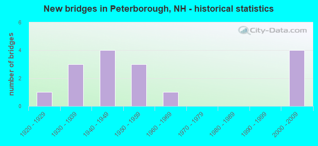
- New bridges - historical statistics
- 11920-1929
- 31930-1939
- 41940-1949
- 31950-1959
- 11960-1969
- 42000-2009
FCC Registered Antenna Towers: 15 (See the full list of FCC Registered Antenna Towers)
FCC Registered Private Land Mobile Towers: 4 (See the full list of FCC Registered Private Land Mobile Towers in Peterborough, NH)
FCC Registered Broadcast Land Mobile Towers: 18 (See the full list of FCC Registered Broadcast Land Mobile Towers)
FCC Registered Microwave Towers: 19 (See the full list of FCC Registered Microwave Towers in this town)
FCC Registered Paging Towers: 4 (See the full list of FCC Registered Paging Towers)
FCC Registered Amateur Radio Licenses: 62 (See the full list of FCC Registered Amateur Radio Licenses in Peterborough)
FAA Registered Aircraft: 9 (See the full list of FAA Registered Aircraft in Peterborough)
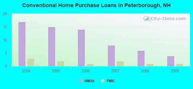
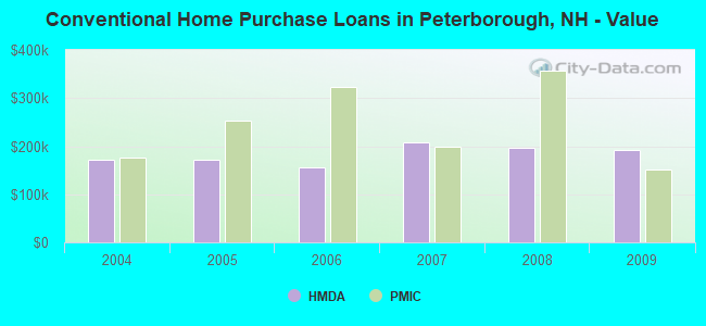
| Home Mortgage Disclosure Act Aggregated Statistics For Year 2009 (Based on 1 partial tract) | ||||||||||
| A) FHA, FSA/RHS & VA Home Purchase Loans | B) Conventional Home Purchase Loans | C) Refinancings | D) Home Improvement Loans | F) Non-occupant Loans on < 5 Family Dwellings (A B C & D) | ||||||
|---|---|---|---|---|---|---|---|---|---|---|
| Number | Average Value | Number | Average Value | Number | Average Value | Number | Average Value | Number | Average Value | |
| LOANS ORIGINATED | 1 | $222,940 | 4 | $192,138 | 21 | $175,170 | 1 | $111,900 | 1 | $168,660 |
| APPLICATIONS APPROVED, NOT ACCEPTED | 0 | $0 | 0 | $0 | 2 | $213,440 | 0 | $0 | 0 | $0 |
| APPLICATIONS DENIED | 0 | $0 | 1 | $124,320 | 6 | $228,528 | 1 | $116,500 | 1 | $148,670 |
| APPLICATIONS WITHDRAWN | 0 | $0 | 0 | $0 | 4 | $177,265 | 0 | $0 | 0 | $0 |
| FILES CLOSED FOR INCOMPLETENESS | 0 | $0 | 0 | $0 | 1 | $249,150 | 0 | $0 | 0 | $0 |
Detailed HMDA statistics for the following Tracts: 0230.00
| Private Mortgage Insurance Companies Aggregated Statistics For Year 2009 (Based on 1 partial tract) | ||
| A) Conventional Home Purchase Loans | ||
|---|---|---|
| Number | Average Value | |
| LOANS ORIGINATED | 1 | $152,270 |
| APPLICATIONS APPROVED, NOT ACCEPTED | 0 | $0 |
| APPLICATIONS DENIED | 0 | $0 |
| APPLICATIONS WITHDRAWN | 0 | $0 |
| FILES CLOSED FOR INCOMPLETENESS | 0 | $0 |
Detailed PMIC statistics for the following Tracts: 0230.00
2002 - 2018 National Fire Incident Reporting System (NFIRS) incidents
- Fire incident types reported to NFIRS in Peterborough, NH
- 25968.2%Structure Fires
- 6216.3%Outside Fires
- 318.2%Mobile Property/Vehicle Fires
- 287.4%Other
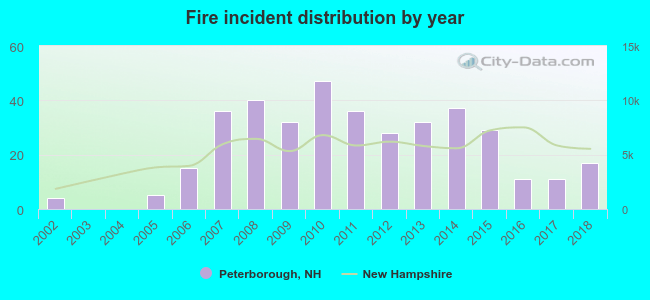 According to the data from the years 2002 - 2018 the average number of fires per year is 22. The highest number of fire incidents - 47 took place in 2010, and the least - 0 in 2003. The data has a growing trend.
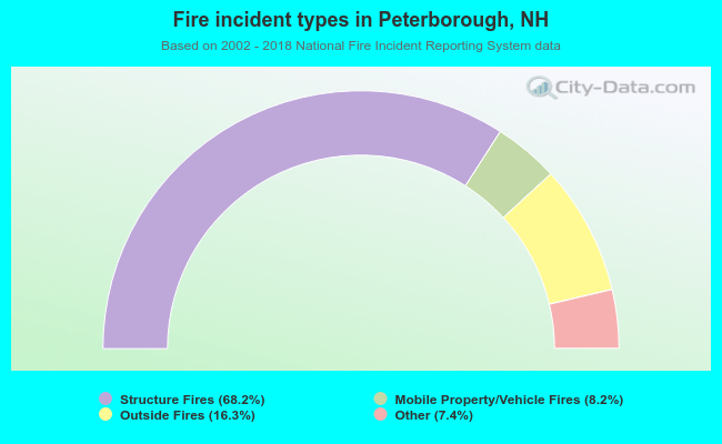 When looking into fire subcategories, the most reports belonged to: Structure Fires (68.2%), and Outside Fires (16.3%).
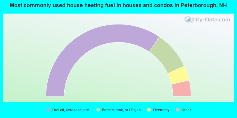
- 69.2%Fuel oil, kerosene, etc.
- 17.1%Bottled, tank, or LP gas
- 6.7%Electricity
- 3.8%Other fuel
- 3.3%Wood
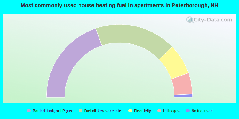
- 39.6%Bottled, tank, or LP gas
- 36.1%Fuel oil, kerosene, etc.
- 13.6%Electricity
- 9.4%Utility gas
- 1.4%No fuel used
Peterborough compared to New Hampshire state average:
- Unemployed percentage below state average.
- Black race population percentage significantly below state average.
- Renting percentage above state average.
- House age above state average.
- Institutionalized population percentage above state average.
- Number of college students below state average.
- Percentage of population with a bachelor's degree or higher above state average.

|
|
Total of 44 patent applications in 2008-2024.