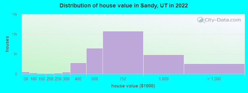
Estimated median house or condo value in 2022: $614,900 (it was $180,700 in 2000)
Sandy:
$614,900
UT:
$499,500
Mean prices in 2022:all housing units: $634,786; detached houses: $660,455; townhouses or other attached units: $476,949; in 2-unit structures: $431,247; in 3-to-4-unit structures: $357,083; in 5-or-more-unit structures: $262,879; mobile homes: $94,914
Median gross rent in 2022: $1,669.
March 2022 cost of living index in Sandy: 93.2 (less than average, U.S. average is 100)
Percentage of residents living in poverty in 2022: 7.4%
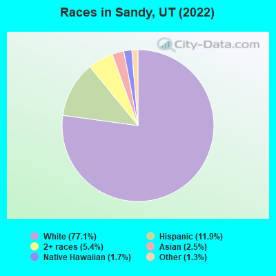
(4.3% for White Non-Hispanic residents, 8.9% for Black residents, 7.5% for Hispanic or Latino residents, 16.8% for Native Hawaiian and other Pacific Islander residents, 5.7% for other race residents, 7.9% for two or more races residents)
According to our research of Utah and other state lists, there were 125 registered sex offenders living in Sandy, Utah as of April 18, 2024. The ratio of all residents to sex offenders in Sandy is 765 to 1. The ratio of registered sex offenders to all residents in this city is lower than the state average.
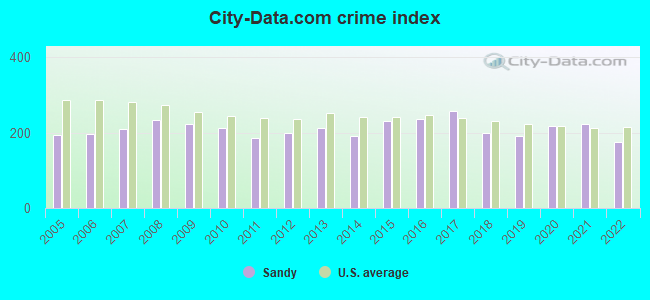
Crime rates in Sandy by year
Type
2009
2010
2011
2012
2013
2014
2015
2016
2017
2018
2019
2020
2021
2022
Murders (per 100,000)
2 (2.1)
1 (1.1)
1 (1.1)
2 (2.2)
1 (1.1)
2 (2.2)
2 (2.2)
0 (0.0)
3 (3.1)
0 (0.0)
3 (3.1)
2 (2.1)
2 (2.1)
1 (1.1)
Rapes (per 100,000)
23 (23.7)
21 (24.0)
18 (20.2)
28 (31.0)
27 (30.0)
23 (25.3)
43 (46.7)
57 (60.3)
62 (63.9)
54 (55.6)
48 (49.1)
36 (37.1)
53 (55.6)
36 (38.7)
Robberies (per 100,000)
23 (23.7)
34 (38.9)
26 (29.2)
35 (38.7)
30 (33.4)
37 (40.7)
29 (31.5)
48 (50.7)
61 (62.9)
21 (21.6)
35 (35.8)
29 (29.9)
41 (43.0)
28 (30.1)
Assaults (per 100,000)
120 (123.7)
104 (118.9)
78 (87.5)
88 (97.3)
77 (85.6)
97 (106.8)
103 (111.9)
56 (59.2)
100 (103.1)
85 (87.6)
103 (105.3)
114 (117.4)
160 (167.8)
115 (123.5)
Burglaries (per 100,000)
566 (583.3)
551 (630.0)
439 (492.4)
457 (505.5)
577 (641.5)
429 (472.2)
578 (628.2)
581 (614.2)
545 (562.1)
408 (420.4)
334 (341.5)
415 (427.4)
333 (349.2)
271 (291.1)
Thefts (per 100,000)
2,689 (2,771)
2,159 (2,469)
2,002 (2,246)
2,083 (2,304)
2,195 (2,440)
1,957 (2,154)
2,164 (2,352)
2,329 (2,462)
2,394 (2,469)
1,941 (2,000)
1,848 (1,890)
2,230 (2,297)
2,067 (2,168)
1,647 (1,769)
Auto thefts (per 100,000)
206 (212.3)
143 (163.5)
195 (218.7)
142 (157.1)
192 (213.5)
169 (186.0)
213 (231.5)
241 (254.8)
270 (278.5)
270 (278.2)
191 (195.3)
355 (365.6)
213 (223.4)
194 (208.4)
Arson (per 100,000)
13 (13.4)
7 (8.0)
7 (7.9)
2 (2.2)
3 (3.3)
7 (7.7)
5 (5.4)
13 (13.7)
4 (4.1)
5 (5.2)
6 (6.1)
13 (13.4)
19 (19.9)
6 (6.4)
City-Data.com crime index
223.6
212.9
186.4
200.4
213.0
192.3
230.1
237.1
257.2
200.2
192.3
217.3
224.1
174.6
The City-Data.com crime index weighs serious crimes and violent crimes more heavily. Higher means more crime, U.S. average is 246.1. It adjusts for the number of visitors and daily workers commuting into cities.
- means the value is smaller than the state average. - means the value is about the same as the state average. - means the value is bigger than the state average. - means the value is much bigger than the state average.
Latest news from Sandy, UT collected exclusively by city-data.com from local newspapers, TV, and radio stations
Ancestries: English (23.5%), European (8.1%), American (6.3%), German (6.1%), Irish (3.1%), Scottish (2.4%).
Current Local Time: MST time zone
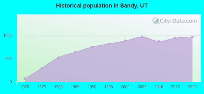
Incorporated in 1893
Elevation: 4450 feet
Land area: 22.3 square miles.
Population density: 4,167 people per square mile (average).
10,675 residents are foreign born (4.4% Latin America, 3.6% Asia, 1.8% Europe).
This city:
11.1%
Utah:
8.4%
Median real estate property taxes paid for housing units with mortgages in 2022: $2,707 (0.4%) Median real estate property taxes paid for housing units with no mortgage in 2022: $2,844 (0.5%)
Nearest city with pop. 200,000+: Las Vegas, NV (353.4 miles , pop. 478,434).
Nearest city with pop. 1,000,000+: Phoenix, AZ (487.4 miles , pop. 1,321,045).
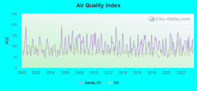
Air Quality Index (AQI) level in 2023 was 95.8. This is worse than average.
City:
95.8
U.S.:
72.6
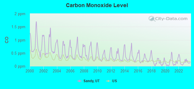
Carbon Monoxide (CO) [ppm] level in 2023 was 0.162. This is significantly better than average.Closest monitor was 2.5 miles away from the city center.
City:
0.162
U.S.:
0.251
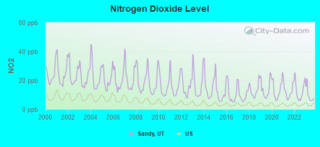
Nitrogen Dioxide (NO2) [ppb] level in 2023 was 9.66. This is significantly worse than average.Closest monitor was 2.5 miles away from the city center.
City:
9.66
U.S.:
5.11
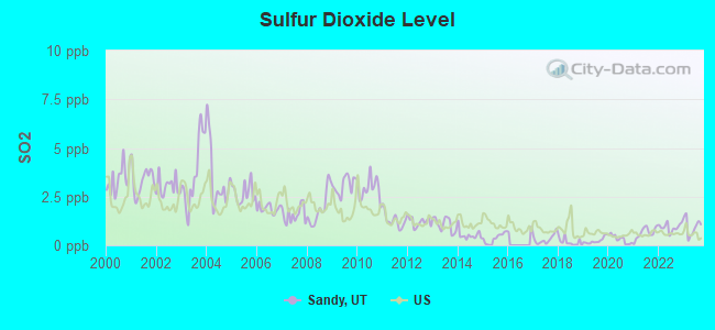
Sulfur Dioxide (SO2) [ppb] level in 2023 was 0.960. This is significantly better than average.Closest monitor was 2.5 miles away from the city center.
City:
0.960
U.S.:
1.515
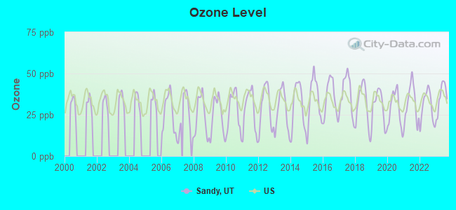
Ozone [ppb] level in 2023 was 36.0. This is about average.Closest monitor was 2.5 miles away from the city center.
City:
36.0
U.S.:
33.3
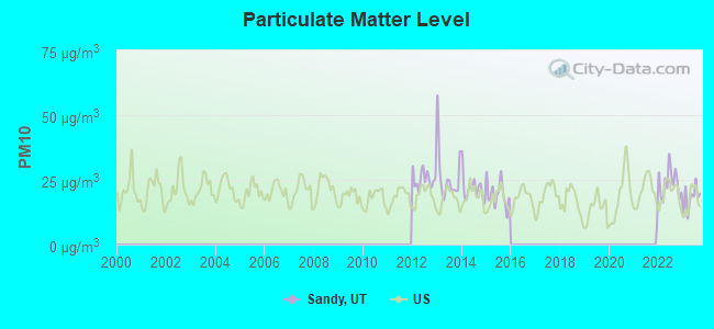
Particulate Matter (PM10) [µg/m3] level in 2023 was 18.0. This is about average.Closest monitor was 5.2 miles away from the city center.
City:
18.0
U.S.:
19.2
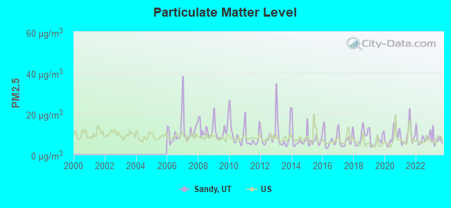
Particulate Matter (PM2.5) [µg/m3] level in 2023 was 7.40. This is about average.Closest monitor was 2.5 miles away from the city center.
City:
7.40
U.S.:
8.11
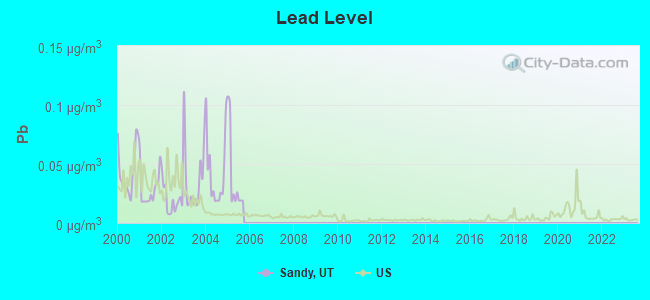
Lead (Pb) [µg/m3] level in 2005 was 0.0394. This is significantly worse than average.Closest monitor was 5.2 miles away from the city center.
City:
0.0394
U.S.:
0.0093
Earthquake activity:
Sandy-area historical earthquake activity is significantly above Utah state average. It is 2197% greater than the overall U.S. average.
On 8/18/1959 at 06:37:13, a magnitude 7.7 (7.7 UK, Class: Major, Intensity: VIII - XII) earthquake occurred 282.9 miles away from Sandy center, causing $26,000,000 total damage On 10/3/1915 at 06:52:48, a magnitude 7.6 (7.6 UK) earthquake occurred 296.5 miles away from the city center On 10/28/1983 at 14:06:06, a magnitude 7.3 (6.2 MB, 7.3 MS, 7.0 MW) earthquake occurred 261.9 miles away from Sandy center, causing 2 deaths (2 shaking deaths) and 3 injuries, causing $15,000,000 total damage On 3/28/1975 at 02:31:05, a magnitude 6.2 (6.1 MB, 6.0 MS, 6.2 ML, Class: Strong, Intensity: VII - IX) earthquake occurred 104.6 miles away from Sandy center On 3/18/2020 at 13:09:31, a magnitude 5.7 (5.7 MW, Depth: 7.4 mi, Class: Moderate, Intensity: VI - VII) earthquake occurred 16.9 miles away from Sandy center On 12/21/1932 at 06:10:09, a magnitude 7.2 (7.2 UK) earthquake occurred 361.2 miles away from the city center Magnitude types: body-wave magnitude (MB), local magnitude (ML), surface-wave magnitude (MS), moment magnitude (MW)
Natural disasters:
The number of natural disasters in Salt Lake County (9) is smaller than the US average (15). Major Disasters (Presidential) Declared: 4 Emergencies Declared: 1
Causes of natural disasters: Floods: 3, Storms: 3, Fires: 2, Landslides: 2, Earthquake: 1, Hurricane: 1, Mudslide: 1, Tornado: 1, Other: 1 (Note: some incidents may be assigned to more than one category).
Main business address for: NEVADA CHEMICALS INC (MISCELLANEOUS CHEMICAL PRODUCTS), FONIX CORP (SERVICES-COMPUTER INTEGRATED SYSTEMS DESIGN).
Hospitals in Sandy:
ALTA VIEW HOSPITAL (Voluntary non-profit - Private, provides emergency services, 9660 SOUTH 1300 EAST)
HILLCREST CARE CENTER (348 EAST 8000 SOUTH)
Nursing Homes in Sandy:
HEALTHSOUTH TRANSITIONAL CARE UNIT (8074 S 1300 E)
KINDRED TRANSITIONAL CARE AND REHABILITATION-CROSS (575 EAST 11000 SOUTH)
SANDY HEALTH AND REHAB (50 EAST 9000 SOUTH)
Dialysis Facilities in Sandy:
SOUTH VALLEY DIALYSIS CENTER (8750 S SANDY PKWY)
Home Health Centers in Sandy:
CANYON CREEK HOME HEALTH CARE (8574 SCOTTISH DRIVE)
GUARDIAN HOME HEALTH CARE (8649 SOUTH 1300 EAST SUITE 100)
HEALTHSOUTH HOME CARE (8074 SOUTH 1300 EAST)
SYMBII HOME HEALTH (45 WEST 10000 SOUTH)
TOTAL KNEE AND HIP REHABILITATION (850 EAST 9400 SOUTH)
14 miles: SALT LAKE CITY (320 S. RIO GRANDE ST.) . Services: ticket office, fully wheelchair accessible, enclosed waiting area, public restrooms, public payphones, vending machines, free short-term parking, free long-term parking, call for car rental service, taxi stand.
DeVry University-Utah (Full-time enrollment: 183; Location: 9350 S 150 E., Ste. 420; Private, for-profit; Website: www.devry.edu; Offers Master's degree)
Francois D College of Hair Skin and Nails (Full-time enrollment: 122; Location: 8932 South State Street; Private, for-profit; Website: echelonedgeacademy.com)
Strayer University-Utah (Full-time enrollment: 119; Location: 9815 S Monroe St Ste 200; Private, for-profit; Website: www.strayer.edu/utah/sandy; Offers Master's degree)
DeVry University's Keller Graduate School of Management-Utah (Location: 9350 South 150 East, Suite 420; Private, for-profit; Website: www.keller.edu; Offers Master's degree)
Notable locations in Sandy: Skyhawk Industrial Park (A), Union Square (B), Country Square (C), Universal Industrial Park (D), Sandy City Fire Department Station 33 (E), Sandy City Fire Department Station 31 (F), Sandy City Fire Department Station 34 (G), Sandy City Fire Department Station 35 (H), Sandy City Fire Department Station 32 (I), South Towne Exposition Center (J). Display/hide their locations on the map
Shopping Centers: Sandy Center Shopping Center (1), Mesa Park Plaza Shopping Center (2), Little Cottonwood Shopping Center (3), Jordan Commons Shopping Center (4), High Point Shopping Center (5), Alta View Center Shopping Center (6), Sandy Mall (7), Plaza 9400 Shopping Center (8), Fiesta Village at Willow Creek Shopping Center (9). Display/hide their locations on the map
Churches in Sandy include: Jehovahs Witnesses Sandy Congregation (A), Sandy Baptist Church (B), Alta Canyon Baptist Church (C), Berean Baptist Church (D), Good Shepherd Lutheran Church (E), Grace Lutheran Church (F), Hilltop United Methodist Church (G), Hope Chapel Foursquare Gospel Church (H), The Church of Jesus Christ of Latter Day Saints (I). Display/hide their locations on the map
Cemeteries: Larkin Sunset Gardens (1), Sandy City Cemetery (2), Granite City Cemetery (3), Lake Hills Memorial Estates (4), Crescent Cemetery (5). Display/hide their locations on the map
Tourist attractions: Solitude Property Management (Ski & Helicopter Tours; 3002 Little Cottonwood Road) (1), Classic Family Fun Center (Amusement & Theme Parks; 9151 South 255 West) (2), Family Fun World - Brunswick Sandy Lanes (Amusement & Theme Parks; 10535 South State Street) (3), Bouncing of the Walls (Amusement & Theme Parks; 398 West 9400 South) (4), All-Star Lanes (Arcades & Amusements; 10535 South State St) (5), Max-Air Productions- Inc (Arcades & Amusements; 9430 South Raintree Drive) (6), Jordan Commons (Arcades & Amusements; 9400 South State St) (7), Endless Adventures (Tours & Charters; 8649 Green Way) (8). Display/hide their approximate locations on the map
Hotels: Comfort Inn Sandy (8955 South 255 West) (1), Hampton Inn Salt Lake City - Sandy (10690 Holiday Park Dr) (2), Extended Stay America - Sandy (10715 Auto Mall Dr) (3), Majestic Rockies Motel (8901 South State Street) (4), Residence Inn by Marriott (270 West Sego Lily Drive) (5), Comfort Suites Sandy (10680 Automall Drive) (6), Castle Creek Inn (7391 Creek Road) (7), Quality Inn & Suites (10680 Auto Mall Dr) (8), Comfort Inn (8955 Harrison St) (9). Display/hide their approximate locations on the map
Birthplace of: Julianne Hough - Professional dancer, The Sandman (wrestler) - Professional wrestler, Doug Jolley - 2005 NFL player (New York Jets, born: Jan 2, 1979), Ryon Bingham - 2005 NFL player (San Diego Chargers, born: Jun 6, 1981), Austin Robinson - College basketball player (Utah Utes), David Oswald - College football player (BYU Cougars), Garner Meads - College basketball player (BYU Cougars), Ray Greenwood - Politician, Steve Kramer (basketball) - Basketball player.
Salt Lake County has a predicted average indoor radon screening level between 2 and 4 pCi/L (pico curies per liter) - Moderate Potential
Drinking water stations with addresses in Sandy and their reported violations in the past:
SANDY CITY WATER SYSTEM (Population served: 99,750, Purch surface water):
MCL, Monthly (TCR) - Between JUL-2006 and SEP-2006, Contaminant: Coliform. Follow-up actions: St Public Notif requested (AUG-28-2006), St Violation/Reminder Notice (AUG-28-2006), St Compliance achieved (JAN-01-2008)
MCL, Monthly (TCR) - Between APR-2006 and JUN-2006, Contaminant: Coliform. Follow-up actions: St Compliance achieved (JAN-01-2008)
ALTA TOWN WATER SYSTEM (Population served: 400, Groundwater):
Past monitoring violations:
Monitoring and Reporting (DBP) - Between JUL-2013 and SEP-2013, Contaminant: Chlorine. Follow-up actions: St Public Notif requested (NOV-17-2013), St Compliance achieved (NOV-17-2013), St Formal NOV issued (NOV-17-2013)
23 regular monitoring violations
WATSON SHELTER WATER SYSTEM (Population served: 340, Groundwater):
Past monitoring violations:
Failure To Address Deficiency - In APR-02-2010, Contaminant: GROUNDWATER RULE
CYPRESS BAY MHP (Serves FL,Population served: 87, Groundwater):
Past health violations:
MCL, Average - Between APR-2007 and JUN-2007, Contaminant: TTHM. Follow-up actions: St BCA signed (DEC-05-2006), St Compliance achieved (SEP-29-2009)
MCL, Average - Between OCT-2006 and DEC-2006, Contaminant: TTHM. Follow-up actions: St BCA signed (DEC-05-2006), St Violation/Reminder Notice (MAR-07-2007), St Public Notif received (APR-27-2007), St Compliance achieved (3 times from AUG-08-2007 to SEP-29-2009)
MCL, Average - Between JUL-2006 and SEP-2006, Contaminant: TTHM. Follow-up actions: St Public Notif received (AUG-28-2006), St Violation/Reminder Notice (SEP-15-2006), St Public Notif received (NOV-20-2006), St BCA signed (DEC-05-2006), St Violation/Reminder Notice (MAR-07-2007), St Public Notif received (APR-27-2007), St Compliance achieved (3 times from AUG-08-2007 to SEP-29-2009)
MCL, Average - Between APR-2006 and JUN-2006, Contaminant: TTHM. Follow-up actions: St Violation/Reminder Notice (SEP-15-2006), St BCA signed (DEC-05-2006), St Violation/Reminder Notice (MAR-07-2007), St Public Notif received (APR-27-2007), St Compliance achieved (3 times from AUG-08-2007 to SEP-29-2009)
MCL, Average - Between OCT-2005 and DEC-2005, Contaminant: TTHM. Follow-up actions: St Public Notif received (DEC-10-2005), St Violation/Reminder Notice (SEP-15-2006), St Compliance achieved (3 times from AUG-08-2007 to SEP-29-2009)
MCL, Average - Between JUL-2005 and SEP-2005, Contaminant: TTHM. Follow-up actions: St Public Notif received (2 times from SEP-27-2005 to OCT-10-2005), St Violation/Reminder Notice (SEP-15-2006), St Compliance achieved (3 times from AUG-08-2007 to SEP-29-2009)
Past monitoring violations:
Failure to Conduct Assessment Monitoring - In FEB-2014, Contaminant: E. COLI. Follow-up actions: St Intentional no-action (MAY-21-2014)
Failure to Conduct Assessment Monitoring - In OCT-2013, Contaminant: E. COLI. Follow-up actions: St Compliance achieved (OCT-30-2013)
Failure to Conduct Assessment Monitoring - In JUL-2013, Contaminant: E. COLI. Follow-up actions: St Compliance achieved (2 times from DEC-31-2012 to AUG-31-2013)
Monitoring and Reporting (DBP) - Between JUL-2013 and SEP-2013, Contaminant: TTHM. Follow-up actions: St Compliance achieved (DEC-31-2012), St Intentional no-action (DEC-31-2012), St Compliance achieved (SEP-29-2013)
Monitoring and Reporting (DBP) - Between JUL-2013 and SEP-2013, Contaminant: Total Haloacetic Acids (HAA5). Follow-up actions: St Compliance achieved (DEC-31-2012), St Intentional no-action (DEC-31-2012), St Compliance achieved (SEP-29-2013)
Drinking water stations with addresses in Sandy that have no violations reported:
MANORLAND WATER DISTRICT NO 1 (Population served: 165,Primary Water Source Type: Groundwater)
MT HAVEN OWNERS ASSOCIATION (Population served: 85,Primary Water Source Type: Groundwater)
WASATCH RESORT (Population served: 20,Primary Water Source Type: Groundwater)
Average household size:
This city:
3.1 people
Utah:
3.1 people
Percentage of family households:
This city:
79.7%
Whole state:
75.2%
Percentage of households with unmarried partners:
This city:
3.8%
Whole state:
4.6%
Likely homosexual households (counted as self-reported same-sex unmarried-partner households)
Lesbian couples: 0.3% of all households
Gay men: 0.2% of all households
People in group quarters in Sandy in 2010:
287 people in nursing facilities/skilled-nursing facilities
43 people in group homes intended for adults
35 people in residential treatment centers for adults
People in group quarters in Sandy in 2000:
304 people in nursing homes
189 people in other noninstitutional group quarters
13 people in training schools for juvenile delinquents
8 people in homes for the mentally retarded
5 people in wards in general hospitals for patients who have no usual home elsewhere
5 people in religious group quarters
Banks with most branches in Sandy (2011 data):
Wells Fargo Bank, National Association: Canyon Center Branch, South Towne Mall Branch, Sandy 7th East Branch, Bell Canyon Branch. Info updated 2011/04/05: Bank assets: $1,161,490.0 mil, Deposits: $905,653.0 mil, headquarters in Sioux Falls, SD, positive income, 6395 total offices, Holding Company: Wells Fargo & Company
Zions First National Bank: East Sandy Branch, Sandy Branch, Sandy Branch. Info updated 2006/11/03: Bank assets: $17,531.3 mil, Deposits: $14,905.3 mil, headquarters in Salt Lake City, UT, positive income, Commercial Lending Specialization, 151 total offices, Holding Company: Zions Bancorporation
U.S. Bank National Association: South Towne Branch, Alta View Smith's Branch, 94th South Smith's Branch. Info updated 2012/01/30: Bank assets: $330,470.8 mil, Deposits: $236,091.5 mil, headquarters in Cincinnati, OH, positive income, 3121 total offices, Holding Company: U.S. Bancorp
JPMorgan Chase Bank, National Association: South Valley Branch, Alta View Branch, Sandy Branch. Info updated 2011/11/10: Bank assets: $1,811,678.0 mil, Deposits: $1,190,738.0 mil, headquarters in Columbus, OH, positive income, International Specialization, 5577 total offices, Holding Company: Jpmorgan Chase & Co.
KeyBank National Association: Sandy Branch at 10281 South State Street, branch established on 1999/06/28; Sandy (Willow Creek) Branch at 8625 South Highland Drive, branch established on 2002/05/28. Info updated 2008/03/03: Bank assets: $86,198.8 mil, Deposits: $64,214.8 mil, headquarters in Cleveland, OH, positive income, Commercial Lending Specialization, 1067 total offices, Holding Company: Keycorp
AmericanWest Bank: Quarry Bend Financial Center at 9080 Village Shop Drive, branch established on 1987/09/14. Info updated 2011/12/12: Bank assets: $2,274.6 mil, Deposits: $1,889.1 mil, headquarters in Spokane, WA, positive income, Commercial Lending Specialization, 76 total offices, Holding Company: Skbhc Holdings Llc
First Utah Bank: Sandy Branch at 11015 South State Street, branch established on 1997/01/16. Info updated 2006/11/03: Bank assets: $253.4 mil, Deposits: $215.2 mil, headquarters in Salt Lake City, UT, negative income in the last year, Commercial Lending Specialization, 8 total offices, Holding Company: First Utah Bancorporation
Utah Community Bank: at 820 East 9400 South, branch established on 2000/07/25. Info updated 2011/02/15: Bank assets: $29.1 mil, Deposits: $24.7 mil, local headquarters, negative income in the last year, Commercial Lending Specialization, 1 total offices, Holding Company: Utah Community Bancorp
Bank of Utah: Sandy Branch at 9320 South State Street, branch established on 2000/04/26. Info updated 2006/11/03: Bank assets: $745.8 mil, Deposits: $601.1 mil, headquarters in Ogden, UT, positive income, Commercial Lending Specialization, 13 total offices, Holding Company: Bou Bancorp, Inc.
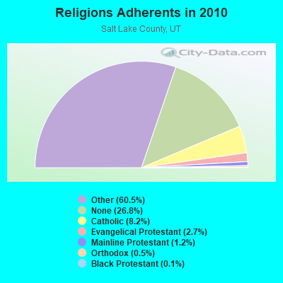
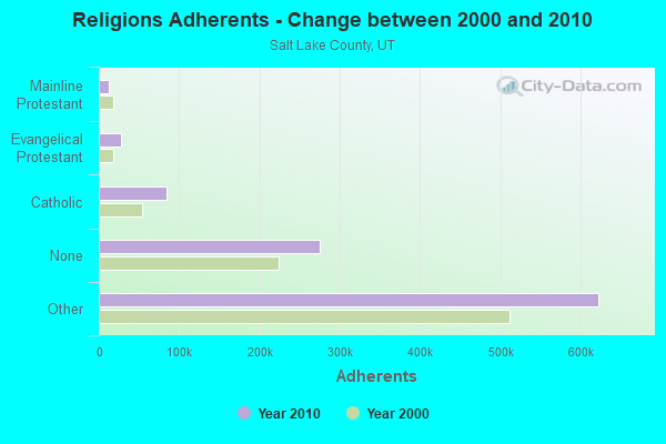
Religion statistics for Sandy, UT (based on Salt Lake County data)
Religion
Adherents
Congregations
Other
622,807
1,452
Catholic
84,342
24
Evangelical Protestant
27,497
144
Mainline Protestant
12,789
38
Orthodox
5,352
7
Black Protestant
1,302
6
None
275,566
-
Source: Clifford Grammich, Kirk Hadaway, Richard Houseal, Dale E.Jones, Alexei Krindatch, Richie Stanley and Richard H.Taylor. 2012. 2010 U.S.Religion Census: Religious Congregations & Membership Study. Association of Statisticians of American Religious Bodies. Jones, Dale E., et al. 2002. Congregations and Membership in the United States 2000. Nashville, TN: Glenmary Research Center. Graphs represent county-level data
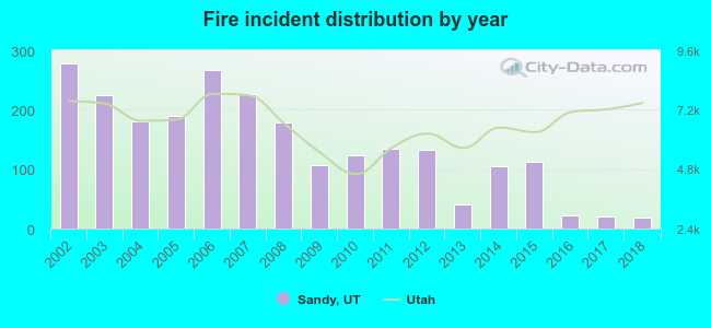
2002 - 2018 National Fire Incident Reporting System (NFIRS) incidents
According to the data from the years 2002 - 2018 the average number of fire incidents per year is 139. The highest number of fire incidents - 277 took place in 2002, and the least - 18 in 2018. The data has a dropping trend.
When looking into fire subcategories, the most reports belonged to: Structure Fires (42.4%), and Outside Fires (35.5%).
Fire incident types reported to NFIRS in Sandy, UT
#5 on the list of "Top 100 cities with biggest houses (pop. 50,000+)"
#20 on the list of "Top 101 cities with the largest percentage of one, detached housing units in structures (20,000+ housing units)"
#28 on the list of "Top 100 cities with highest median household income and median resident age less than 35 (pop. 50,000+)"
#30 on the list of "Top 101 cities with the most cars per house, population 50,000+"
#37 on the list of "Top 100 highest located cities (pop. 50,000+)"
#46 on the list of "Top 101 cities with the smallest percentage of unmarried partner households (population 50,000+)"
#47 on the list of "Top 101 cities with the lowest number of arson incidents per 100,000 residents (population 50,000+)"
#54 on the list of "Top 101 cities with largest percentage of females in industries: mining, quarrying, and oil and gas extraction (population 50,000+)"
#55 on the list of "Top 101 cities with the lowest minimum monthly morning or afternoon humidity (population 50,000+)"
#58 on the list of "Top 101 cities with largest percentage of females in occupations: education, training, and library occupations (population 50,000+)"
#59 on the list of "Top 101 cities with the highest percentage of workers working at home, population 50,000+"
#63 on the list of "Top 101 cities with the highest ratio of rapes to murders between 2002 and 2012 (population 50,000+)"
#64 on the list of "Top 101 cities with largest percentage of females in industries: utilities (population 50,000+)"
#68 on the list of "Top 101 cities with largest percentage of females in industries: information (population 50,000+)"
#68 on the list of "Top 100 least racially diverse cities (pop. 50,000+)"
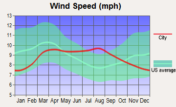
#69 on the list of "Top 101 cities with the lowest average wind speeds (population 50,000+)"
#70 on the list of "Top 101 cities with the lowest average humidity (population 50,000+)"
#76 on the list of "Top 101 cities with largest percentage of females in industries: retail trade (population 50,000+)"
#77 on the list of "Top 101 cities with the smallest household incomes disparities (population 50,000+)"
#79 on the list of "Top 101 cities with the least people below 50% of the poverty level (population 50,000+)"
#91 (84094) on the list of "Top 101 zip codes with the largest percentage of Danish first ancestries (pop 5,000+)"
#1 on the list of "Top 101 counties with the most Other adherents"
#1 on the list of "Top 101 counties with the most Other congregations"
#4 on the list of "Top 101 counties with the lowest percentage of residents that smoked 100+ cigarettes in their lives"
#11 on the list of "Top 101 counties with the highest Nitrogen Dioxide air pollution readings in 2012 (ppm)"
#14 on the list of "Top 101 counties with the highest number of births per 1000 residents 2007-2013"


 Recent articles from our blog. Our writers, many of them Ph.D. graduates or candidates, create easy-to-read articles on a wide variety of topics.

 (353.4 miles


 According to the data from the years 2002 - 2018 the average number of fire incidents per year is 139. The highest number of fire incidents - 277 took place in 2002, and the least - 18 in 2018. The data has a dropping trend.
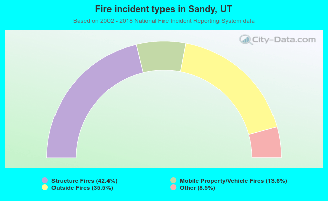 When looking into fire subcategories, the most reports belonged to: Structure Fires (42.4%), and Outside Fires (35.5%).