Springfield, Missouri

Springfield: National Ave at James River Freeway
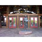
Springfield: Bass Pro Main Store
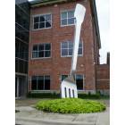
Springfield: Located in Chesterfield Village, the giant fork at the entrance to Noble advertising firm is a bit off the well-trodden tourist trail.

Springfield: Fountain of Peace
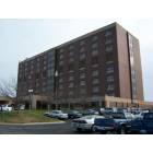
Springfield: Cox South
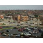
Springfield: National Ave at Primrose Street from Cox South
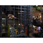
Springfield: Bass Pro Main Store
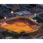
Springfield: Hammons Field in Springfield Missouri
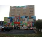
Springfield: A beautiful folk art mural at Jefferson Ave. and Park Central East funded by the local arts council in downtown
Springfield: National Ave crossing James River Frwy from Cox South
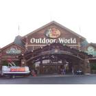
Springfield: Bass Pro Main Store
- see
46
more - add
your
Submit your own pictures of this city and show them to the world
- OSM Map
- General Map
- Google Map
- MSN Map
Population change since 2000: +12.2%
 |
| Males: 84,791 | |
| Females: 85,276 |
| Median resident age: | 33.6 years |
| Missouri median age: | 39.1 years |
Zip codes: 65757, 65803, 65804, 65806, 65809.
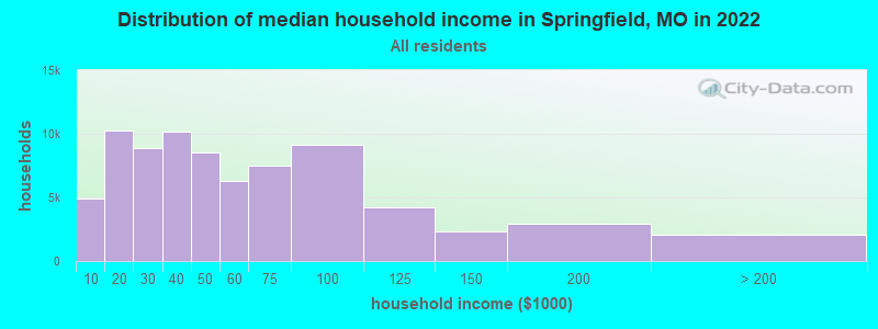
Springfield Zip Code Map| Springfield: | $45,400 |
| MO: | $64,811 |
Estimated per capita income in 2022: $28,455 (it was $17,711 in 2000)
Springfield city income, earnings, and wages data
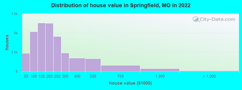
Estimated median house or condo value in 2022: $166,400 (it was $78,700 in 2000)
| Springfield: | $166,400 |
| MO: | $221,200 |
Mean prices in 2022: all housing units: $193,645; detached houses: $197,421; townhouses or other attached units: $229,458; in 2-unit structures: $156,478; in 3-to-4-unit structures: $168,898; in 5-or-more-unit structures: $262,280; mobile homes: $48,270; occupied boats, rvs, vans, etc.: $94,807
Median gross rent in 2022: $900.
(19.8% for White Non-Hispanic residents, 34.3% for Black residents, 20.2% for Hispanic or Latino residents, 19.8% for American Indian residents, 8.0% for Native Hawaiian and other Pacific Islander residents, 30.1% for other race residents, 24.9% for two or more races residents)
Detailed information about poverty and poor residents in Springfield, MO


Compare current foreclosures in Springfield, MO:
| Photo | Address | Area | Beds / Baths | Price | Details |
|---|---|---|---|---|---|

|
#1
N Main Ave
Springfield, MO 65803
|
2,401 sq. feet
|
2 baths 3 beds |
$87,500
|
show details |

|
#2
N Nettleton Ave
Springfield, MO 65802
|
768 sq. feet
|
1 baths 2 beds |
$135,000
|
show details |

|
#3
W Harrison St
Springfield, MO 65802
|
1,011 sq. feet
|
2 baths 2 beds |
$153,000
|
show details |

|
#4
Farm Road 92
Springfield, MO 65803
|
2,725 sq. feet
|
3 baths 4 beds |
show details | |

|
#5
S Dayton Ave
Springfield, MO 65807
|
1,428 sq. feet
|
2 baths 3 beds |
show details | |

|
#6
N Pierce Ave
Springfield, MO 65803
|
1,552 sq. feet
|
1 baths 3 beds |
show details | |

|
#7
W Farm Rd 94
Springfield, MO 65803
|
1,214 sq. feet
|
2 baths 3 beds |
show details | |

|
#8
E Talmage St
Springfield, MO 65803
|
1,275 sq. feet
|
2 baths 3 beds |
show details | |

|
#9
W Lee St
Springfield, MO 65803
|
768 sq. feet
|
2 baths 2 beds |
show details | |

|
#10
E Barcelona Pl
Springfield, MO 65804
|
2,262 sq. feet
|
2 baths 2 beds |
show details |
| Photo | Address | Area | Beds / Baths | Price | Details |
|---|---|---|---|---|---|

|
#11
W Atlantic St
Springfield, MO 65803
|
1,104 sq. feet
|
2 baths 4 beds |
show details | |

|
#12
N Washington Ave
Springfield, MO 65803
|
1,646 sq. feet
|
1 baths 2 beds |
show details | |

|
#13
E Farm Rd 84
Springfield, MO 65803
|
1,376 sq. feet
|
1 baths 3 beds |
show details | |

|
#14
N Waverly Ave
Springfield, MO 65803
|
1,352 sq. feet
|
1 baths 3 beds |
show details | |

|
#15
S Westwood Ave
Springfield, MO 65807
|
1,360 sq. feet
|
2 baths 3 beds |
show details | |

|
#16
S Christopher Ave
Springfield, MO 65802
|
1,695 sq. feet
|
2 baths 3 beds |
show details | |

|
#17
N Albertha Ave
Springfield, MO 65803
|
1,744 sq. feet
|
1 baths 3 beds |
show details | |

|
#18
S Ferguson Ave
Springfield, MO 65807
|
1,167 sq. feet
|
1 baths 3 beds |
show details | |

|
#19
S Walnut Hill Rd
Springfield, MO 65810
|
1,975 sq. feet
|
2 baths 3 beds |
show details | |

|
#20
S Delaware Ave
Springfield, MO 65802
|
1,760 sq. feet
|
2 baths 3 beds |
show details |
| Photo | Address | Area | Beds / Baths | Price | Details |
|---|---|---|---|---|---|

|
#21
S Cottage Ave
Springfield, MO 65807
|
1,188 sq. feet
|
2 baths 3 beds |
show details | |

|
#22
N Daniels Pl
Springfield, MO 65803
|
1,502 sq. feet
|
2 baths 3 beds |
show details | |

|
#23
W Washita St
Springfield, MO 65807
|
2,016 sq. feet
|
2 baths 2 beds |
show details | |

|
#24
E Whiteside St
Springfield, MO 65807
|
1,120 sq. feet
|
1 baths 3 beds |
show details | |

|
#25
S Sieger Dr
Springfield, MO 65804
|
1,520 sq. feet
|
2 baths 3 beds |
show details | |

|
#26
E Guinevere St
Springfield, MO 65807
|
1,447 sq. feet
|
2 baths 3 beds |
show details | |

|
#27
E Cairo St
Springfield, MO 65802
|
838 sq. feet
|
1 baths 2 beds |
show details | |

|
#28
N Elizabeth Ave
Springfield, MO 65803
|
1,294 sq. feet
|
1 baths 3 beds |
show details | |

|
#29
E Pacific St
Springfield, MO 65802
|
1,483 sq. feet
|
2 baths 3 beds |
show details | |

|
#30
W Scott St
Springfield, MO 65802
|
1,040 sq. feet
|
2 baths 3 beds |
show details |
| Photo | Address | Area | Beds / Baths | Price | Details |
|---|---|---|---|---|---|

|
#31
S Blueridge Pl
Springfield, MO 65809
|
2,754 sq. feet
|
3 baths 4 beds |
show details | |

|
#32
E Monroe St
Springfield, MO 65802
|
1,040 sq. feet
|
1 baths 3 beds |
show details | |

|
#33
W Webster St
Springfield, MO 65802
|
1,058 sq. feet
|
1 baths 3 beds |
show details | |

|
#34
S Miami Ct
Springfield, MO 65807
|
1,664 sq. feet
|
2 baths 3 beds |
show details | |

|
#35
W Sunset Dr
Springfield, MO 65802
|
1,950 sq. feet
|
2 baths 3 beds |
show details | |

|
#36
S Keystone Ave
Springfield, MO 65807
|
1,335 sq. feet
|
2 baths 3 beds |
show details | |

|
#37
N Hayes Ave
Springfield, MO 65803
|
816 sq. feet
|
1 baths 2 beds |
show details | |

|
#38
W Woodland St
Springfield, MO 65807
|
2,336 sq. feet
|
3 baths 4 beds |
show details | |

|
#39
S Kickapoo Ave
Springfield, MO 65804
|
1,476 sq. feet
|
1 baths 2 beds |
show details | |

|
#40
E Wayland St
Springfield, MO 65804
|
1,832 sq. feet
|
2 baths 3 beds |
show details |
| Photo | Address | Area | Beds / Baths | Price | Details |
|---|---|---|---|---|---|

|
#41
E Maryland Ct
Springfield, MO 65810
|
3,785 sq. feet
|
2 baths 4 beds |
show details | |

|
#42
S Ivy Cir
Springfield, MO 65802
|
1,856 sq. feet
|
2 baths 4 beds |
show details | |

|
#43
S Shady Lane Ct
Springfield, MO 65810
|
1,608 sq. feet
|
2 baths 3 beds |
show details | |

|
#44
S Farm Road 131
Springfield, MO 65810
|
2,058 sq. feet
|
2 baths 3 beds |
show details | |

|
#45
E Walnut St
Springfield, MO 65802
|
1,392 sq. feet
|
1 baths 3 beds |
show details | |

|
#46
W Berkeley Ct
Springfield, MO 65807
|
3,000 sq. feet
|
3 baths 4 beds |
show details | |

|
#47
E Farm Road 88
Springfield, MO 65803
|
968 sq. feet
|
1 baths 2 beds |
show details | |

|
#48
E Adams St
Springfield, MO 65803
|
1,364 sq. feet
|
2 baths 3 beds |
show details | |

|
#49
E State Highway Aa
Springfield, MO 65803
|
1,200 sq. feet
|
1 baths 3 beds |
show details | |

|
Check over 1 million property listings on Foreclosure.com!
|
browse all offers | |||


- 141,01882.9%White alone
- 8,6245.1%Two or more races
- 8,7255.1%Hispanic
- 7,0964.2%Black alone
- 2,2361.3%Asian alone
- 1,3050.8%Other race alone
- 7170.4%Native Hawaiian and Other
Pacific Islander alone - 3410.2%American Indian alone
Races in Springfield detailed stats: ancestries, foreign born residents, place of birth
According to our research of Missouri and other state lists, there were 861 registered sex offenders living in Springfield, Missouri as of April 23, 2024.
The ratio of all residents to sex offenders in Springfield is 194 to 1.
The City-Data.com crime index weighs serious crimes and violent crimes more heavily. Higher means more crime, U.S. average is 246.1. It adjusts for the number of visitors and daily workers commuting into cities.
- means the value is smaller than the state average.- means the value is about the same as the state average.
- means the value is bigger than the state average.
- means the value is much bigger than the state average.
Crime rate in Springfield detailed stats: murders, rapes, robberies, assaults, burglaries, thefts, arson
Full-time law enforcement employees in 2021, including police officers: 386 (309 officers - 269 male; 40 female).
| Officers per 1,000 residents here: | 1.83 |
| Missouri average: | 2.54 |
 Recent articles from our blog. Our writers, many of them Ph.D. graduates or candidates, create easy-to-read articles on a wide variety of topics.

 | Springfield, MO Crime Rate (Is it Really That Bad?) (24 replies) |
| Another moving to Springfield post, hope it's interesting... (1 reply) |
| Is Springfield, Mo really that racist? (186 replies) |
| Springfield Nissan dealer (9 replies) |
| Single Mom Possibly Moving to Springfield, MO (7 replies) |
| Questions for first scout trip to Springfield-Branson (2 replies) |
Latest news from Springfield, MO collected exclusively by city-data.com from local newspapers, TV, and radio stations
Ancestries: German (10.7%), American (9.7%), English (8.4%), Irish (5.7%), European (3.6%), Italian (1.6%).
Current Local Time: CST time zone
Incorporated in 1838
Elevation: 1300 feet
Land area: 73.2 square miles.
Population density: 2,325 people per square mile (low).
5,924 residents are foreign born (1.7% Asia, 0.7% Latin America, 0.6% Europe, 0.4% Africa).
| This city: | 3.5% |
| Missouri: | 4.2% |
Median real estate property taxes paid for housing units with mortgages in 2022: $1,240 (0.7%)
Median real estate property taxes paid for housing units with no mortgage in 2022: $1,236 (0.8%)
Nearest city with pop. 200,000+: Kansas City, MO  (147.3 miles , pop. 441,545).
Nearest city with pop. 1,000,000+: Dallas, TX (362.9 miles , pop. 1,188,580).
Nearest cities:
), ), ), Latitude: 37.20 N, Longitude: 93.29 W
Daytime population change due to commuting: +70,801 (+41.6%)
Workers who live and work in this city: 70,032 (85.6%)
Area code: 417
Springfield tourist attractions:
- American National Fish and Wildlife Museum - Springfield MO Wildlife Park Zoo Museum
- Crystal Cave - Springfield MO - Cave Rock Formation Crystal
- Dickerson Park Zoo in Springfield, Missouri
- Discovery Center - Springfield MO - Childrens Museum Springfield
- Fantastic Caverns - Springfield MO - Show Cave Drive Through Jeep
- University Plaza Hotel & Convention Center - Springfield MO University Hotel Events
- Wonders of Wildlife Museum & Aquarium - Springfield, Missouri - public aquarium, museum, and tourist attraction
Springfield, Missouri accommodation & food services, waste management - Economy and Business Data
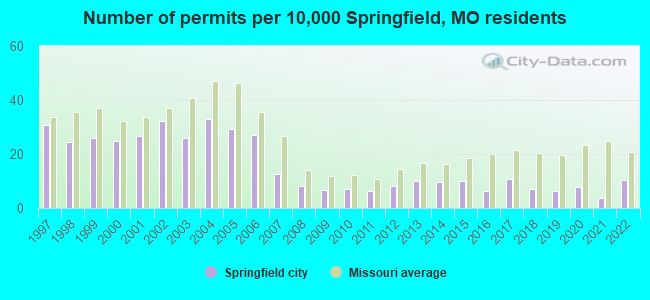
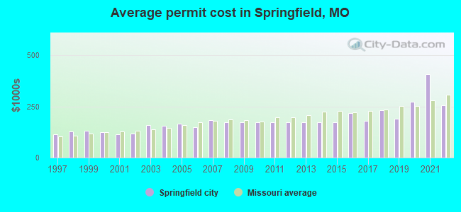
Single-family new house construction building permits:
- 2022: 155 buildings, average cost: $254,400
- 2021: 58 buildings, average cost: $407,500
- 2020: 118 buildings, average cost: $273,800
- 2019: 96 buildings, average cost: $187,800
- 2018: 106 buildings, average cost: $232,100
- 2017: 162 buildings, average cost: $178,900
- 2016: 97 buildings, average cost: $219,000
- 2015: 154 buildings, average cost: $173,400
- 2014: 146 buildings, average cost: $173,400
- 2013: 152 buildings, average cost: $173,400
- 2012: 126 buildings, average cost: $173,400
- 2011: 98 buildings, average cost: $173,400
- 2010: 105 buildings, average cost: $173,400
- 2009: 103 buildings, average cost: $173,700
- 2008: 125 buildings, average cost: $172,400
- 2007: 189 buildings, average cost: $181,800
- 2006: 412 buildings, average cost: $149,200
- 2005: 443 buildings, average cost: $166,800
- 2004: 498 buildings, average cost: $153,700
- 2003: 394 buildings, average cost: $157,600
- 2002: 486 buildings, average cost: $117,100
- 2001: 404 buildings, average cost: $114,000
- 2000: 377 buildings, average cost: $123,400
- 1999: 394 buildings, average cost: $130,100
- 1998: 369 buildings, average cost: $128,100
- 1997: 464 buildings, average cost: $114,800
| Here: | 2.4% |
| Missouri: | 2.8% |
Population change in the 1990s: +10,057 (+7.1%).
- Health care (13.4%)
- Accommodation & food services (12.6%)
- Educational services (11.0%)
- Professional, scientific, technical services (4.8%)
- Administrative & support & waste management services (4.5%)
- Construction (4.0%)
- Finance & insurance (4.0%)
- Accommodation & food services (13.0%)
- Construction (7.1%)
- Educational services (6.7%)
- Health care (6.1%)
- Administrative & support & waste management services (5.4%)
- Professional, scientific, technical services (4.6%)
- Finance & insurance (3.6%)
- Health care (21.0%)
- Educational services (15.5%)
- Accommodation & food services (12.2%)
- Professional, scientific, technical services (5.0%)
- Finance & insurance (4.4%)
- Social assistance (4.2%)
- Administrative & support & waste management services (3.5%)
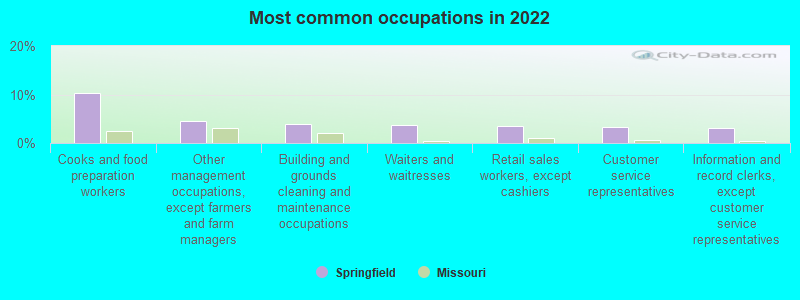
- Cooks and food preparation workers (10.3%)
- Other management occupations, except farmers and farm managers (4.6%)
- Building and grounds cleaning and maintenance occupations (3.9%)
- Waiters and waitresses (3.7%)
- Retail sales workers, except cashiers (3.5%)
- Customer service representatives (3.4%)
- Information and record clerks, except customer service representatives (3.1%)
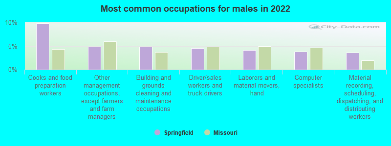
- Cooks and food preparation workers (9.8%)
- Other management occupations, except farmers and farm managers (4.8%)
- Building and grounds cleaning and maintenance occupations (4.8%)
- Driver/sales workers and truck drivers (4.5%)
- Laborers and material movers, hand (4.1%)
- Computer specialists (3.8%)
- Material recording, scheduling, dispatching, and distributing workers (3.6%)
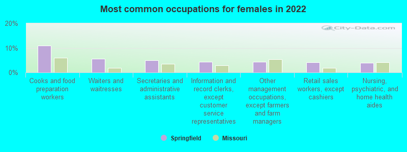
- Cooks and food preparation workers (10.8%)
- Waiters and waitresses (5.7%)
- Secretaries and administrative assistants (5.0%)
- Information and record clerks, except customer service representatives (4.4%)
- Other management occupations, except farmers and farm managers (4.3%)
- Retail sales workers, except cashiers (4.1%)
- Nursing, psychiatric, and home health aides (4.0%)
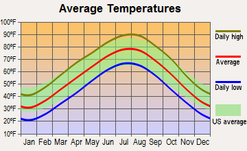
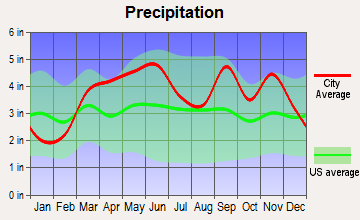
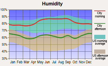
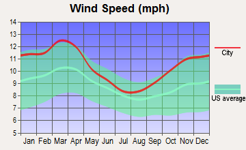
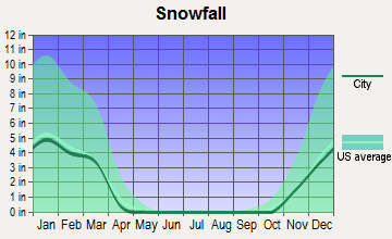
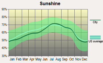
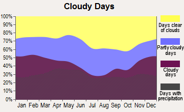
Average climate in Springfield, Missouri
Based on data reported by over 4,000 weather stations
|
|

(lower is better)
Air Quality Index (AQI) level in 2022 was 70.1. This is about average.
| City: | 70.1 |
| U.S.: | 72.6 |
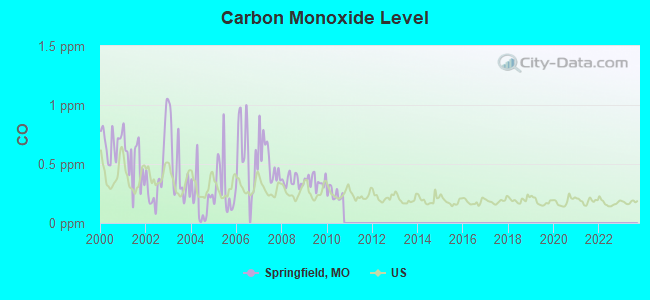
Carbon Monoxide (CO) [ppm] level in 2010 was 0.246. This is about average. Closest monitor was 0.3 miles away from the city center.
| City: | 0.246 |
| U.S.: | 0.251 |
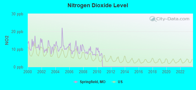
Nitrogen Dioxide (NO2) [ppb] level in 2010 was 7.97. This is significantly worse than average. Closest monitor was 1.6 miles away from the city center.
| City: | 7.97 |
| U.S.: | 5.11 |

Sulfur Dioxide (SO2) [ppb] level in 2010 was 1.84. This is worse than average. Closest monitor was 0.3 miles away from the city center.
| City: | 1.84 |
| U.S.: | 1.51 |
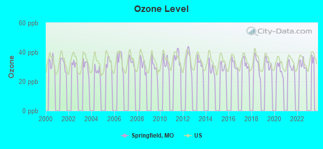
Ozone [ppb] level in 2022 was 31.8. This is about average. Closest monitor was 1.6 miles away from the city center.
| City: | 31.8 |
| U.S.: | 33.3 |
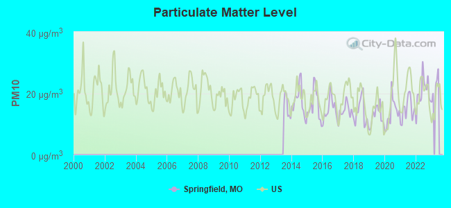
Particulate Matter (PM10) [µg/m3] level in 2022 was 20.4. This is about average. Closest monitor was 0.3 miles away from the city center.
| City: | 20.4 |
| U.S.: | 19.2 |
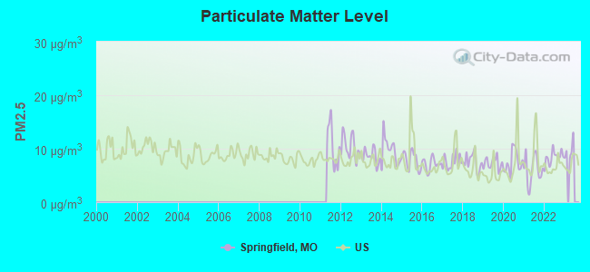
Particulate Matter (PM2.5) [µg/m3] level in 2022 was 8.38. This is about average. Closest monitor was 0.3 miles away from the city center.
| City: | 8.38 |
| U.S.: | 8.11 |
Tornado activity:
Springfield-area historical tornado activity is slightly below Missouri state average. It is 41% greater than the overall U.S. average.
On 11/29/1991, a category F4 (max. wind speeds 207-260 mph) tornado 3.7 miles away from the Springfield city center killed 2 people and injured 64 people and caused between $5,000,000 and $50,000,000 in damages.
On 4/29/1983, a category F3 (max. wind speeds 158-206 mph) tornado 6.0 miles away from the city center killed one person and injured 19 people and caused between $5,000,000 and $50,000,000 in damages.
Earthquake activity:
Springfield-area historical earthquake activity is significantly above Missouri state average. It is 556% greater than the overall U.S. average.On 9/3/2016 at 12:02:44, a magnitude 5.8 (5.8 MW, Depth: 3.5 mi, Class: Moderate, Intensity: VI - VII) earthquake occurred 208.6 miles away from the city center
On 11/6/2011 at 03:53:10, a magnitude 5.7 (5.7 MW, Depth: 3.2 mi) earthquake occurred 225.3 miles away from the city center
On 5/4/1991 at 01:18:54, a magnitude 5.0 (4.4 MB, 4.6 LG, 5.0 LG, Depth: 3.1 mi) earthquake occurred 196.5 miles away from the city center
On 3/25/1976 at 00:41:20, a magnitude 5.0 (4.9 MB, 5.0 LG) earthquake occurred 196.8 miles away from Springfield center
On 2/28/2011 at 05:00:50, a magnitude 4.7 (4.7 MW, Depth: 2.0 mi, Class: Light, Intensity: IV - V) earthquake occurred 143.0 miles away from the city center
On 9/26/1990 at 13:18:51, a magnitude 5.0 (4.7 MB, 4.8 LG, 5.0 LG, Depth: 7.7 mi) earthquake occurred 206.7 miles away from the city center
Magnitude types: regional Lg-wave magnitude (LG), body-wave magnitude (MB), moment magnitude (MW)
Natural disasters:
The number of natural disasters in Greene County (23) is greater than the US average (15).Major Disasters (Presidential) Declared: 14
Emergencies Declared: 6
Causes of natural disasters: Floods: 15, Storms: 14, Tornadoes: 8, Winter Storms: 6, Winds: 3, Drought: 1, Hurricane: 1, Other: 1 (Note: some incidents may be assigned to more than one category).
Main business address for: HAMMONS JOHN Q HOTELS INC (HOTELS & MOTELS), GREAT SOUTHERN BANCORP INC (STATE COMMERCIAL BANKS), SLS INTERNATIONAL INC (HOUSEHOLD AUDIO & VIDEO EQUIPMENT), O REILLY AUTOMOTIVE INC (RETAIL-AUTO & HOME SUPPLY STORES), HAMMONS JOHN Q HOTELS LP (HOTELS & MOTELS), MUELLER PAUL CO (FABRICATED PLATE WORK (BOILER SHOPS)), GUARANTY FEDERAL BANCSHARES INC (STATE COMMERCIAL BANKS), HAMMONS JOHN Q HOTELS LP (HOTELS & MOTELS).
Hospitals in Springfield:
- COMMUNITY HOSPICES OF AMERICA (1465 E. PRIMROSE, SUITE A)
- COX MEDICAL CENTER (Voluntary non-profit - Private, provides emergency services, 3801 SOUTH NATIONAL AVENUE)
- DOCTOR'S HOSPITAL OF SPRINGFIELD INC (provides emergency services, 2828 N NATIONAL BOX 783)
- HARTLINE HOSPICE (3322 S CAMPBELL)
- HOSPICE AND PALLIATIVE CARE OF SPRINGFIELD LLC (1538 SOUTH ENTERPRISE)
- MERCY HOSPITAL SPRINGFIELD (Voluntary non-profit - Church, 1235 E CHEROKEE)
- OZARKS COMMUNITY HOSPITAL (Proprietary, provides emergency services, 2828 NORTH NATIONAL)
- REGIONAL HOSPICE (1328 EAST EVERGREEN)
- SEASONS HOSPICE, INC (1831 W MELVILLE ROAD)
- SOUTHERNCARE SPRINGFIELD (777 EAST BATTLEFIELD, SUITE 104 A)
- ST JOHN'S HOSPICECARE (1378 E REPUBLIC ROAD, PO BOX 4086)
Airports and heliports located in Springfield:
- Springfield-Branson National Airport (SGF) (Runways: 2, Commercial Ops: 5,648, Air Taxi Ops: 15,188, Itinerant Ops: 15,737, Local Ops: 2,400, Military Ops: 4,251)
- Downtown Airport (3DW) (Runways: 1, Air Taxi Ops: 425, Itinerant Ops: 6,460, Local Ops: 2,482, Military Ops: 85)
- Flying Bar H Ranch Airport (MO2) (Runways: 1, Itinerant Ops: 80, Local Ops: 400)
- Childress Airstrip Airport (MU12) (Runways: 1)
- Gardner Airport (39MO) (Runways: 2)
- Lester E Cox Medical Center North Heliport (MU59)
- Lester E Cox Medical Center South Heliport (56MU)
- Mercy Hospital-Springfield Heliport (81MU)
- Van's Heliport (MU39)
Biggest Colleges/Universities in Springfield:
- Missouri State University-Springfield (Full-time enrollment: 16,660; Location: 901 S National; Public; Website: www.missouristate.edu; Offers Doctor's degree)
- Ozarks Technical Community College (Full-time enrollment: 10,356; Location: 1001 E. Chestnut Expressway; Public; Website: www.otc.edu)
- Drury University (Full-time enrollment: 3,902; Location: 900 N.Benton; Private, not-for-profit; Website: www.drury.edu; Offers Master's degree)
- Evangel University (Full-time enrollment: 2,036; Location: 1111 N Glenstone; Private, not-for-profit; Website: www.evangel.edu; Offers Master's degree)
- Vatterott College-Springfield (Full-time enrollment: 522; Location: 3850 South Campbell; Private, for-profit; Website: www.vatterott.edu)
- Bryan University (Full-time enrollment: 458; Location: 4255 Nature Center Way; Private, for-profit; Website: www.bryanu.edu; Offers Master's degree)
- Cox College (Full-time enrollment: 375; Location: 1423 N Jefferson; Private, not-for-profit; Website: www.coxcollege.edu; Offers Master's degree)
- Everest College-Springfield (Full-time enrollment: 346; Location: 1010 W Sunshine; Private, for-profit; Website: www.everest.edu/campus/springfield)
- Baptist Bible College (Full-time enrollment: 325; Location: 628 E Kearney; Private, not-for-profit; Website: www.gobbc.edu; Offers Master's degree)
- ITT Technical Institute-Springfield (Full-time enrollment: 212; Location: 3216 S. National Ave; Private, for-profit; Website: www.itt-tech.edu)
- Paul Mitchell the School-Springfield (Full-time enrollment: 195; Location: 3017 S Kansas Expy; Private, for-profit; Website: www.thesystemonline.com)
- Assemblies of God Theological Seminary (Full-time enrollment: 183; Location: 1435 N Glenstone Ave; Private, not-for-profit; Website: www.agts.edu; Offers Doctor's degree)
- Academy of Hair Design-Springfield (Full-time enrollment: 157; Location: 1834 S Glenstone; Private, for-profit; Website: aohd.com/)
- Missouri College of Cosmetology North (Full-time enrollment: 115; Location: 3014 E Sunshine St Ste G; Private, for-profit; Website: www.missouricosmo.com)
- University of Phoenix-Springfield Campus (Full-time enrollment: 111; Location: 1343 E Kingsley St; Private, for-profit; Website: www.phoenix.edu; Offers Master's degree)
- Forest Institute of Professional Psychology (Full-time enrollment: 86; Location: 2885 W Battlefield Rd; Private, not-for-profit; Website: www.forest.edu; Offers Doctor's degree)
- Regency Beauty Institute-Springfield (Full-time enrollment: 72; Location: 1415 E Battlefield, Unit 1415; Private, for-profit; Website: www.regency.edu)
- Professional Massage Training Center (Full-time enrollment: 60; Location: 229 East Commercial Street; Private, for-profit; Website: www.pmtc.edu)
- Mercy Hospital Springfield-School of Radiologic Technology (Full-time enrollment: 45; Location: 1235 E Cherokee St; Private, not-for-profit; Website: www.mercy.net/springfieldmo)
- Victory Trade School (Full-time enrollment: 31; Location: 1715 N Boonville Ave; Private, not-for-profit; Website: www.victorytradeschool.edu)
Other colleges/universities with over 2000 students near Springfield:
- Southwest Baptist University (about 29 miles; Bolivar, MO; Full-time enrollment: 2,783)
- Missouri Southern State University (about 66 miles; Joplin, MO; FT enrollment: 4,456)
- Crowder College (about 66 miles; Neosho, MO; FT enrollment: 3,675)
- NorthWest Arkansas Community College (about 76 miles; Bentonville, AR; FT enrollment: 5,634)
- Pittsburg State University (about 80 miles; Pittsburg, KS; FT enrollment: 6,838)
- Northeastern Oklahoma A&M College (about 90 miles; Miami, OK; FT enrollment: 2,075)
- University of Arkansas (about 93 miles; Fayetteville, AR; FT enrollment: 22,163)
Biggest public high schools in Springfield:
- KICKAPOO HIGH (Students: 1,766, Location: 3710 S JEFFERSON, Grades: 9-12)
- PARKVIEW HIGH (Students: 1,574, Location: 516 W MEADOWMERE, Grades: 9-12)
- GLENDALE HIGH (Students: 1,537, Location: 2727 S INGRAM MILL, Grades: 9-12)
- HILLCREST HIGH (Students: 1,264, Location: 3319 N GRANT, Grades: 9-12)
- WILSON CREEK GROUP HOME (Location: 3992 W SUNSHINE, Grades: 6-12)
- EXCEL SCHOOL (Location: 1631 W BENNETT, Grades: 6-12)
- DATEMA HOUSE (Location: 918 S JEFFERSON, Grades: 5-12)
- GREENE VALLEY SCHOOL (Location: 1601 E PYTHIAN, Grades: KG-12)
- JUVENILE JUSTICE CTR. (Location: 1111 N ROBBERSON, Grades: 7-12)
- CENTRAL HIGH (Location: 423 E CENTRAL, Grades: 6-12)
Private high schools in Springfield:
- GREENWOOD LABORATORY SCHOOL (Students: 374, Location: 1024 E HARRISON, Grades: KG-12)
- NEW COVENANT ACADEMY (Students: 346, Location: 3304 S COX RD, Grades: KG-12)
- SPRINGFIELD CATHOLIC HIGH SCHOOL (Students: 333, Location: 2340 S EASTGATE AVE, Grades: 9-12)
- CHRISTIAN SCHOOLS OF SPRINGFIELD (Students: 151, Location: 2660 N GRANT AVE, Grades: PK-12)
- THE SUMMIT (Students: 136, Location: 2155 W CHESTERFIELD BLVD, Grades: PK-12)
- DAYSPRING CHRISTIAN SCHOOL (Students: 70, Location: 2157 N PROSPECT AVE, Grades: PK-12)
- PARK AVENUE CHRISTIAN SCHOOL (Students: 42, Location: 2850 N PARK AVE, Grades: 1-12)
- SPRINGFIELD SEVENTH-DAY ADVENTIST JUNIOR ACADEMY (Students: 35, Location: 704 S BELVIEW AVE, Grades: KG-10)
Biggest public elementary/middle schools in Springfield:
- PERSHING ELEM. (Students: 783, Location: 2120 VENTURA, Grades: KG-5)
- CHEROKEE MIDDLE (Students: 721, Location: 420 E FARM RD 182, Grades: 6-8)
- CARVER MIDDLE (Students: 711, Location: 3325 W BATTLEFIELD, Grades: 6-8)
- MCBRIDE ELEM. (Students: 614, Location: 5005 S FARM RD 135, Grades: PK-4)
- JARRETT MIDDLE (Students: 572, Location: 840 S JEFFERSON, Grades: 6-8)
- WALT DISNEY ELEM. (Students: 566, Location: 4100 S FREMONT, Grades: KG-5)
- JEFFRIES ELEM. (Students: 556, Location: 4051 S SCENIC, Grades: PK-5)
- REED MIDDLE (Students: 547, Location: 2000 N LYON, Grades: 6-8)
- PIPKIN MIDDLE (Students: 531, Location: 1215 BOONVILLE, Grades: 6-8)
- WESTPORT MIDDLE SCHOOL (Students: 491, Location: 2343 W OLIVE, Grades: 6-8)
Private elementary/middle schools in Springfield:
- IMMACULATE CONCEPTION SCHOOL (Students: 500, Location: 3555A S FREMONT AVE, Grades: PK-8)
- ST AGNES ELEMENTARY SCHOOL (Students: 230, Location: 531 S JEFFERSON AVE, Grades: PK-8)
- SPRINGFIELD LUTHERAN SCHOOL (Students: 218, Location: 2852 S DAYTON AVE, Grades: PK-8)
- ST ELIZABETH ANN SETON SCHOOL (Students: 180, Location: 2200 W REPUBLIC RD, Grades: PK-6)
- ST JOSEPH CATHOLIC ACADEMY (Students: 104, Location: 515 W SCOTT ST, Grades: PK-8)
- DISCOVERY GARDEN MONTESSORI SCHOOL (Students: 28, Location: 2434 E BATTLEFIELD ST, Grades: PK-1)
Library in Springfield:
- SPRINGFIELD-GREENE COUNTY LIBRARY DISTRICT (Operating income: $11,743,880; Location: 4653 S CAMPBELL; 471,195 books; 151 e-books; 26,690 audio materials; 43,933 video materials; 40 local licensed databases; 14 state licensed databases; 2 other licensed databases; 1,175 print serial subscriptions; 14 electronic serial subscriptions)
User-submitted facts and corrections:
- Southwest Missouri State University has changed it's name to Missouri State University
- the main public school is no longer called Southern Missouri State Universtity... Its call Missouri State University.
- The name of Southwest Missouri State Universtiy was changed to Missouri State University (dropping the regional designation).
- KZRQ FM radio was acquired by Journal Broadcast Group years ago.
Points of interest:
Notable locations in Springfield: Smith Golf Course (A), Grandview Golf Course (B), Sheltering Heights Camp (C), Dublin (D), South Junction (E), Chadwick Junction (F), Fremont Center (G), Battlefield Plaza (H), Town and Country Plaza (I), Logan - Rogersville Fire Protection District Station 2 (J), Springfield Fire Department Station 2 (K), Greene County Alms House (L), Springfield Fire Department Station 10 (M), Springfield Fire Department Station 8 (N), Springfield Fire Department Station 6 (O), Springfield Fire Department Station 3 (P), Springfield Fire Department Station 1 (Q), Springfield Fire Department Station 11 (R), Springfield Fire Department Station 9 (S), Springfield Fire Department Station 7 (T). Display/hide their locations on the map
Shopping Centers: Parkcrest Village Shopping Center (1), Battlefield Mall Shopping Center (2), Southgate Shopping Center (3), Wedgewood Shopping Center (4), Southern Hills Shopping Center (5), North Town Mall (6), Westport Shopping Center (7). Display/hide their locations on the map
Main business address in Springfield include: HAMMONS JOHN Q HOTELS INC (A), GREAT SOUTHERN BANCORP INC (B), SLS INTERNATIONAL INC (C), O REILLY AUTOMOTIVE INC (D), HAMMONS JOHN Q HOTELS LP (E), MUELLER PAUL CO (F), GUARANTY FEDERAL BANCSHARES INC (G), HAMMONS JOHN Q HOTELS LP (H). Display/hide their locations on the map
Churches in Springfield include: Grandview Church (A), Calvary Church (B). Display/hide their locations on the map
Cemeteries: Lincoln Memorial Park Cemetery (1), East Lawn Cemetery (2), Kirkwood Cemetery (3), Hazelwood Cemetery (4), Maple Park Cemetery (5), Rivermonte Memorial Gardens (6), Saint Marys Cemetery (7). Display/hide their locations on the map
Reservoirs: Lake Springfield (A), Valley Water Mill Pond (B). Display/hide their locations on the map
Streams, rivers, and creeks: Thompson Creek (A), Mustard Branch (B), Westport Branch (C), South Fork Ward Branch (D), South Fork Pea Ridge Creek (E), Sequiota Spring Branch (F), Sanford Branch (G), Sander Branch (H), North Fork Ward Branch (I). Display/hide their locations on the map
Parks in Springfield include: Grant Park (1), Grant Beach Park (2), Glenwood Park (3), Fassnight Park (4), Smith Park (5), Durst Park (6), Doling Park (7), Dickerson Park (8), Kirkwood Park (9). Display/hide their locations on the map
Tourist attractions: Air & Military Museum of the Ozarks (2305 East Kearney Street) (1), Discovery Center of Springfield Science Center (Museums; 438 East Saint Louis Street) (2), History Museum for Springfield & Greene County (830 North Boonville Avenue) (3), AMER Nat'l Fish & Wildlife Museum (500 West Sunshine Street) (4), Crystal Cave (Caverns; 7225 East Crystal Cave Lane) (5), Southwest Missouri Museum Associates (Cultural Attractions- Events- & Facilities; 1111 East Brookside Drive) (6), Richardson LOYD (Caverns; 7225 East Crystal Cave Lane) (7), Fantastic Caverns (Caverns; 4872 North Farm Road 125) (8), Libraries - Brentwood Branch (Cultural Attractions- Events- & Facilities; 2214 South Brentwood Boulevard) (9). Display/hide their approximate locations on the map
Hotels: Missouri Hotel (420 East Commercial Street) (1), Comfort Inn South (3330 East Battlefield Road) (2), Econo Lodge South (3404 East Ridgeview Street) (3), Holiday Inn (333 S John Q Hammons Pkwy) (4), Cox Medical Centers - Plaza Hotel (3800 South National Avenue Suite 300) (5), Microtel Inn (3125 North Kentwood Avenue) (6), Comfort Inn (3330 East Battlefield Street) (7), Hampton Inn & Suites Springfield- MO (2750 North Glenstone) (8), Hampton Inn Springfield-East (222 North Ingram Mill Road) (9). Display/hide their approximate locations on the map
Courts: Greene County Government - Judicial And Law Enforcement- Family Courts- Commissioner Tinsley S (940 North Boonville Avenue) (1), Greene County Government - Judicial And Law Enforcement- Family Courts- Commissioner Davis Win (940 North Boonville Avenue) (2), Missouri State - Court Of Appeals- Clerk Of Court (300 South John Q Hammons Parkway) (3), U S Government - Courts- District Court- Judge (3003 East Chestnut Expressway) (4), Greene County Government - Judicial And Law Enforcement- Circuit Court Informa (940 North Boonville Avenue) (5), Greene County Government - Judicial And Law Enforcement- Probate Court D (1010 North Boonville Avenue) (6), Missouri State - Public Safety Dept- Missouri State Veterans Cemetery (5201 South Southwood Road) (7), U S Government - Courts- Bankruptcy Court (222 North John Q Hammons Parkway) (8), U S Government - Courts- District Court- Clerk (222 North John Q Hammons Parkway) (9). Display/hide their approximate locations on the map
Birthplace of: Matt Blunt - Politician, George Jackson (baseball) - Professional baseball player, Kathleen Turner - Actress, Lucas Grabeel - Springfield, James Billings - Opera singer, Shawn Brixey - Artist, William Garwood - Actor, Alex Carder - Football player, Roy Smalley, Jr. - Baseball player, Artie Romero - Artist.
Drinking water stations with addresses in Springfield and their reported violations in the past:
GENERAL COUNCIL ASSEMBLIES OF GOD (Address: 1445 N BOONVILLE AVE , Population served: 1,070, Groundwater):Past health violations:SPRINGHILL BAPTIST CHURCH (Population served: 600, Groundwater):Past monitoring violations:
- MCL, Monthly (TCR) - In SEP-2005, Contaminant: Coliform. Follow-up actions: St Public Notif requested (OCT-27-2005), St Violation/Reminder Notice (OCT-27-2005), St Public Notif received (DEC-10-2005), St Compliance achieved (JAN-22-2014)
- Lead Consumer Notice - In JAN-01-2011, Contaminant: Lead and Copper Rule
- One regular monitoring violation
Past health violations:MODOT I 44 REST AREA CONWAY (Population served: 500, Groundwater):Past monitoring violations:
- MCL, Monthly (TCR) - In SEP-2007, Contaminant: Coliform. Follow-up actions: St Public Notif requested (OCT-02-2007), St Violation/Reminder Notice (OCT-02-2007), St BCA signed (JAN-26-2009), St Compliance achieved (DEC-10-2010)
- One routine major monitoring violation
Past monitoring violations:RAPID ROBERTS 106 (Population served: 400, Groundwater):
- One routine major monitoring violation
- 2 minor monitoring violations
Past health violations:COLONY COVE MHP (Address: 3951 S MENTOR 54 , Population served: 210, Groundwater):Past monitoring violations:
- MCL, Monthly (TCR) - In AUG-2005, Contaminant: Coliform. Follow-up actions: St Violation/Reminder Notice (SEP-07-2005), St Public Notif requested (SEP-07-2005)
- 8 routine major monitoring violations
- One minor monitoring violation
Past monitoring violations:SPRINGFIELD LIVESTOCK MARKETING CTR (Population served: 200, Groundwater):
- 2 routine major monitoring violations
Past health violations:HARVEST CHURCH (Population served: 150, Groundwater):Past monitoring violations:
- MCL, Monthly (TCR) - In OCT-2009, Contaminant: Coliform. Follow-up actions: St Violation/Reminder Notice (OCT-23-2009), St Public Notif requested (OCT-23-2009), St Public Notif issued (2 times from JUN-01-2010 to SEP-23-2010), St Compliance achieved (SEP-30-2010), St BCA signed (DEC-10-2010), St Public Notif received (AUG-15-2011), St Compliance achieved (FEB-10-2012)
- MCL, Monthly (TCR) - In FEB-2005, Contaminant: Coliform. Follow-up actions: St Violation/Reminder Notice (MAR-29-2005), St Public Notif requested (MAR-29-2005), St Public Notif issued (6 times from AUG-24-2007 to SEP-23-2010), St Public Notif received (AUG-15-2011)
- 19 routine major monitoring violations
- 7 minor monitoring violations
- One regular monitoring violation
Past monitoring violations:COUNTRY MEADOWS ESTATES (Address: 426 S JEFFERSON , Population served: 150, Groundwater):
- Monitoring, Source Water (GWR) - In MAY-01-2012, Contaminant: E. COLI. Follow-up actions: St Violation/Reminder Notice (MAY-23-2012), St Public Notif requested (MAY-23-2012), St Formal NOV issued (JAN-22-2013), St BCA signed (MAR-04-2013), St Compliance achieved (AUG-20-2013), St Public Notif received (OCT-29-2013), St Compliance achieved (MAR-31-2014)
- 13 routine major monitoring violations
- One minor monitoring violation
Past monitoring violations:
- Follow-up Or Routine LCR Tap M/R - In OCT-01-2010, Contaminant: Lead and Copper Rule. Follow-up actions: St Public Notif requested (NOV-10-2010), St Violation/Reminder Notice (NOV-10-2010), St Compliance achieved (AUG-19-2011), St Public Notif received (SEP-02-2011)
- Follow-up Or Routine LCR Tap M/R - In OCT-01-2004, Contaminant: Lead and Copper Rule. Follow-up actions: St Compliance achieved (AUG-23-2007)
- One regular monitoring violation
Drinking water stations with addresses in Springfield that have no violations reported:
- WORKFORCE HOUSING ODESSA MAN CAMP (Serves TX, Population served: 75, Primary Water Source Type: Groundwater)
- O'REILLY AUTO PARTS OCALA (Serves FL, Population served: 25, Primary Water Source Type: Groundwater)
| This city: | 2.1 people |
| Missouri: | 2.5 people |
| This city: | 50.8% |
| Whole state: | 65.3% |
| This city: | 8.2% |
| Whole state: | 6.7% |
Likely homosexual households (counted as self-reported same-sex unmarried-partner households)
- Lesbian couples: 0.4% of all households
- Gay men: 0.3% of all households
People in group quarters in Springfield in 2010:
- 6,591 people in college/university student housing
- 1,443 people in nursing facilities/skilled-nursing facilities
- 1,151 people in federal prisons
- 411 people in local jails and other municipal confinement facilities
- 314 people in group homes intended for adults
- 235 people in other noninstitutional facilities
- 214 people in emergency and transitional shelters (with sleeping facilities) for people experiencing homelessness
- 139 people in residential treatment centers for juveniles (non-correctional)
- 96 people in state prisons
- 83 people in residential treatment centers for adults
- 36 people in group homes for juveniles (non-correctional)
- 18 people in correctional facilities intended for juveniles
- 8 people in mental (psychiatric) hospitals and psychiatric units in other hospitals
People in group quarters in Springfield in 2000:
- 6,829 people in college dormitories (includes college quarters off campus)
- 1,376 people in nursing homes
- 1,265 people in federal prisons and detention centers
- 710 people in other noninstitutional group quarters
- 227 people in local jails and other confinement facilities (including police lockups)
- 137 people in other group homes
- 92 people in homes for the mentally ill
- 90 people in residential treatment centers for emotionally disturbed children
- 79 people in hospitals/wards and hospices for chronically ill
- 79 people in hospices or homes for chronically ill
- 60 people in homes for the mentally retarded
- 37 people in halfway houses
- 33 people in religious group quarters
- 30 people in homes or halfway houses for drug/alcohol abuse
- 16 people in short-term care, detention or diagnostic centers for delinquent children
- 14 people in homes for abused, dependent, and neglected children
- 11 people in training schools for juvenile delinquents
- 7 people in unknown juvenile institutions
- 6 people in other nonhousehold living situations
Banks with most branches in Springfield (2011 data):
- Great Southern Bank: 16 branches. Info updated 2012/02/03: Bank assets: $3,788.7 mil, Deposits: $2,986.3 mil, headquarters in Reeds Spring, MO, positive income, Commercial Lending Specialization, 109 total offices, Holding Company: Great Southern Bancorp, Inc.
- Empire Bank: 11 branches. Info updated 2010/10/18: Bank assets: $1,024.1 mil, Deposits: $867.6 mil, local headquarters, positive income, Commercial Lending Specialization, 23 total offices, Holding Company: Central Bancompany
- U.S. Bank National Association: 8 branches. Info updated 2012/01/30: Bank assets: $330,470.8 mil, Deposits: $236,091.5 mil, headquarters in Cincinnati, OH, positive income, 3121 total offices, Holding Company: U.S. Bancorp
- Bank of America, National Association: 7 branches. Info updated 2009/11/18: Bank assets: $1,451,969.3 mil, Deposits: $1,077,176.8 mil, headquarters in Charlotte, NC, positive income, 5782 total offices, Holding Company: Bank Of America Corporation
- Commerce Bank: 7 branches. Info updated 2011/07/07: Bank assets: $20,493.6 mil, Deposits: $16,805.3 mil, headquarters in Kansas City, MO, positive income, 206 total offices, Holding Company: Commerce Bancshares, Inc.
- BancorpSouth Bank: Kearney Branch, Sunshine Branch, Campbell Branch, Battlefield Branch, Signature Bank Branch, Fremont Branch. Info updated 2007/07/18: Bank assets: $12,990.3 mil, Deposits: $10,863.8 mil, headquarters in Tupelo, MS, positive income, Commercial Lending Specialization, 271 total offices, Holding Company: Bancorpsouth, Inc.
- Liberty Bank: West Bypass Branch, Campbell Branch, at 4625 South National Avenue, Sunshine Branch, Primrose Branch, Republic Rd. Info updated 2011/03/28: Bank assets: $1,093.3 mil, Deposits: $919.6 mil, local headquarters, positive income, Commercial Lending Specialization, 19 total offices, Holding Company: Liberty Bancshares, Inc
- Guaranty Bank: 1510 E Sunshine Branch, - Republic Road Branch, 4343 South National Avenue Branch, 2109 N Glenstone Branch, West Kearney Branch, at 1341 West Battlefield. Info updated 2011/01/18: Bank assets: $647.7 mil, Deposits: $485.8 mil, local headquarters, positive income, Commercial Lending Specialization, 9 total offices, Holding Company: Guaranty Federal Bancshares, Inc.
- Arvest Bank: East Sunshine Branch, West Republic Road Branch, North National Avenue Branch, Springfield Branch. Info updated 2010/11/29: Bank assets: $12,520.8 mil, Deposits: $10,446.2 mil, headquarters in Fayetteville, AR, positive income, Commercial Lending Specialization, 241 total offices, Holding Company: Arvest Bank Group, Inc.
- 19 other banks with 32 local branches
For population 15 years and over in Springfield:
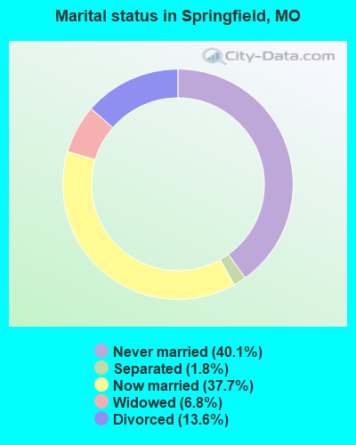
- Never married: 40.1%
- Now married: 37.7%
- Separated: 1.8%
- Widowed: 6.8%
- Divorced: 13.6%
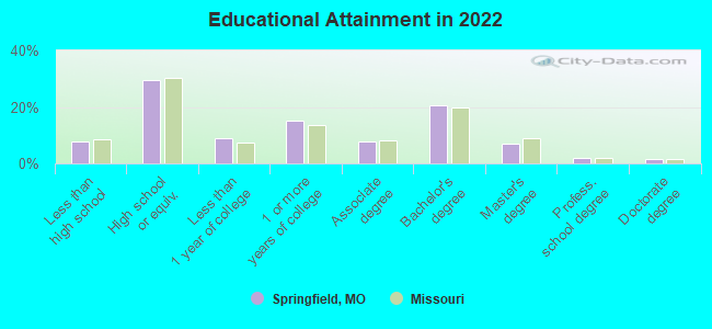
For population 25 years and over in Springfield:
- High school or higher: 92.3%
- Bachelor's degree or higher: 31.2%
- Graduate or professional degree: 10.7%
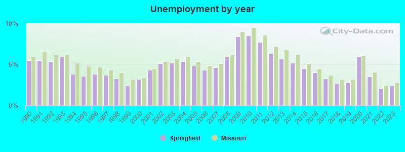
- Unemployed: 6.6%
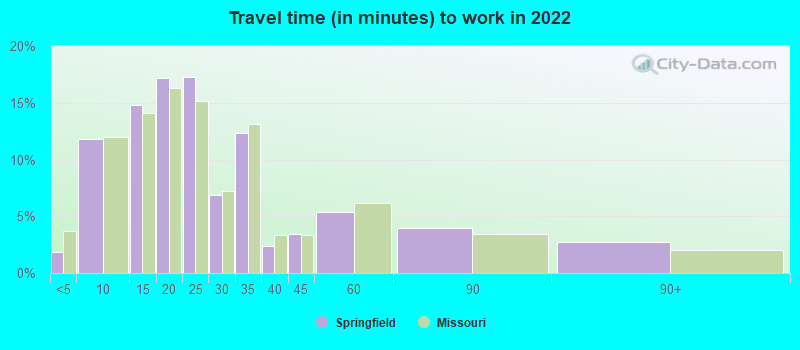
- Mean travel time to work (commute): 16.6 minutes
| Here: | 10.6 |
| Missouri average: | 11.1 |
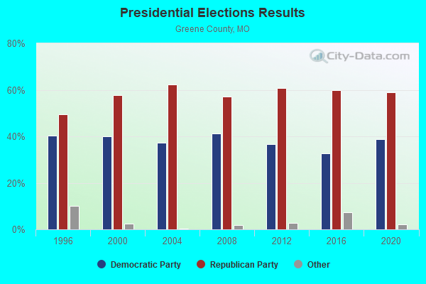
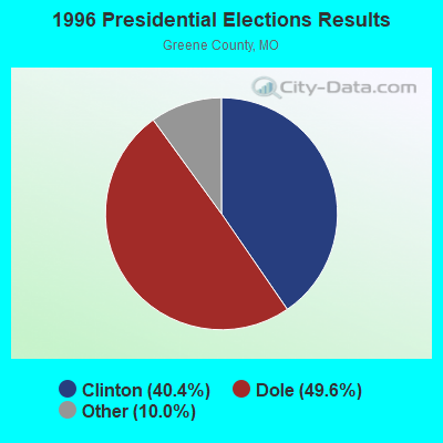
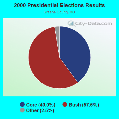

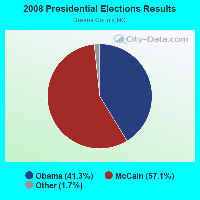
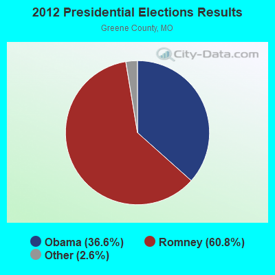

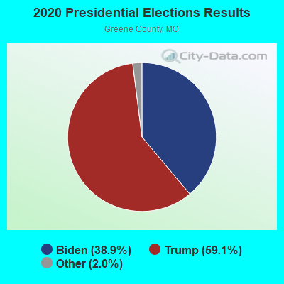
Graphs represent county-level data. Detailed 2008 Election Results
Neighborhoods in Springfield:
(Springfield, Missouri Neighborhood Map)- Central neighborhood
- Cinnamon Square neighborhood
- Cooper Estates neighborhood
- Downtown neighborhood
- Fairfield Acres neighborhood
- Fox Grape neighborhood
- Glenwood Village neighborhood
- Grant Beach neighborhood
- Kingsbury Forest neighborhood
- Midtown (Mid-Town) neighborhood
- Northeast neighborhood
- Northwest neighborhood
- Parkwest Village neighborhood
- Phelps Grove neighborhood
- Quail Creek neighborhood
- Ravenwood neighborhood
- Ravenwood South neighborhood
- Rountree neighborhood
- Shady Dell (Webster Park) neighborhood
- Sherman Avenue neighborhood
- Southeast neighborhood
- Southwest neighborhood
- Spring Creek neighborhood
- University Heights neighborhood
- Walnut Street neighborhood
- Weller neighborhood
- West Central neighborhood
- Westside neighborhood
- Woodland Heights neighborhood
Religion statistics for Springfield, MO (based on Greene County data)
| Religion | Adherents | Congregations |
|---|---|---|
| Evangelical Protestant | 96,521 | 258 |
| Mainline Protestant | 25,250 | 59 |
| Catholic | 15,294 | 6 |
| Other | 5,731 | 26 |
| Black Protestant | 624 | 4 |
| Orthodox | 121 | 2 |
| None | 131,633 | - |
Food Environment Statistics:
| This county: | 1.33 / 10,000 pop. |
| Missouri: | 1.88 / 10,000 pop. |
| Here: | 0.23 / 10,000 pop. |
| Missouri: | 0.18 / 10,000 pop. |
| This county: | 0.15 / 10,000 pop. |
| State: | 0.60 / 10,000 pop. |
| This county: | 3.60 / 10,000 pop. |
| Missouri: | 4.34 / 10,000 pop. |
| Greene County: | 8.11 / 10,000 pop. |
| State: | 7.37 / 10,000 pop. |
| Greene County: | 8.0% |
| Missouri: | 8.8% |
| Greene County: | 29.1% |
| Missouri: | 29.6% |
| This county: | 12.3% |
| Missouri: | 13.5% |
Health and Nutrition:
| Springfield: | 51.2% |
| Missouri: | 50.9% |
| This city: | 49.6% |
| Missouri: | 48.6% |
| Springfield: | 28.3 |
| State: | 28.7 |
| Here: | 20.0% |
| Missouri: | 20.6% |
| Springfield: | 10.4% |
| Missouri: | 10.1% |
| Springfield: | 6.9 |
| Missouri: | 6.8 |
| Springfield: | 31.9% |
| State: | 34.3% |
| This city: | 58.7% |
| Missouri: | 57.5% |
| This city: | 79.6% |
| State: | 79.3% |
More about Health and Nutrition of Springfield, MO Residents
| Local government employment and payroll (March 2022) | |||||
| Function | Full-time employees | Monthly full-time payroll | Average yearly full-time wage | Part-time employees | Monthly part-time payroll |
|---|---|---|---|---|---|
| Other and Unallocable | 572 | $4,089,167 | $85,787 | 21 | $40,081 |
| Police Protection - Officers | 315 | $1,871,021 | $71,277 | 0 | $0 |
| Electric Power | 253 | $2,477,371 | $117,504 | 6 | $10,338 |
| Parks and Recreation | 241 | $1,080,451 | $53,798 | 395 | $295,948 |
| Firefighters | 214 | $1,214,410 | $68,098 | 0 | $0 |
| Streets and Highways | 205 | $1,057,653 | $61,911 | 1 | $903 |
| Sewerage | 151 | $819,368 | $65,115 | 2 | $1,985 |
| Water Supply | 107 | $803,188 | $90,077 | 8 | $19,116 |
| Airports | 92 | $414,416 | $54,054 | 4 | $8,629 |
| Transit | 90 | $272,904 | $36,387 | 0 | $0 |
| Gas Supply | 85 | $650,969 | $91,902 | 1 | $2,037 |
| Health | 76 | $401,851 | $63,450 | 36 | $45,084 |
| Police - Other | 69 | $281,286 | $48,919 | 5 | $7,683 |
| Other Government Administration | 67 | $422,745 | $75,716 | 4 | $17,108 |
| Financial Administration | 61 | $357,969 | $70,420 | 2 | $1,902 |
| Judicial and Legal | 40 | $248,366 | $74,510 | 6 | $12,782 |
| Solid Waste Management | 40 | $190,522 | $57,157 | 0 | $0 |
| Welfare | 20 | $83,522 | $50,113 | 1 | $1,352 |
| Fire - Other | 8 | $36,220 | $54,330 | 0 | $0 |
| Totals for Government | 2,706 | $16,773,400 | $74,383 | 492 | $464,948 |
Springfield government finances - Expenditure in 2021 (per resident):
- Construction - Electric Utilities: $23,000,000 ($135.24)
Sewerage: $21,376,000 ($125.69)
Regular Highways: $13,049,000 ($76.73)
Gas Utilities: $12,000,000 ($70.56)
General - Other: $5,740,000 ($33.75)
Air Transportation: $3,789,000 ($22.28)
Parks and Recreation: $922,000 ($5.42)
- Current Operations - Electric Utilities: $203,537,000 ($1196.80)
Gas Utilities: $85,189,000 ($500.91)
Police Protection: $70,145,000 ($412.46)
Parks and Recreation: $38,466,000 ($226.18)
Water Utilities: $26,779,000 ($157.46)
Local Fire Protection: $25,496,000 ($149.92)
Sewerage: $24,572,000 ($144.48)
Miscellaneous Commercial Activities - Other: $19,872,000 ($116.85)
Air Transportation: $14,306,000 ($84.12)
Regular Highways: $11,809,000 ($69.44)
Transit Utilities: $11,386,000 ($66.95)
Health - Other: $9,971,000 ($58.63)
Central Staff Services: $7,787,000 ($45.79)
General - Other: $7,481,000 ($43.99)
General Public Buildings: $7,264,000 ($42.71)
Solid Waste Management: $7,002,000 ($41.17)
Judicial and Legal Services: $4,131,000 ($24.29)
Housing and Community Development: $3,917,000 ($23.03)
Public Welfare - Other: $3,778,000 ($22.21)
Protective Inspection and Regulation - Other: $3,163,000 ($18.60)
Financial Administration: $3,071,000 ($18.06)
Parking Facilities: $364,000 ($2.14)
- General - Interest on Debt: $9,329,000 ($54.85)
- Other Capital Outlay - Solid Waste Management: $3,280,000 ($19.29)
Housing and Community Development: $2,419,000 ($14.22)
Police Protection: $1,421,000 ($8.36)
Local Fire Protection: $646,000 ($3.80)
General - Other: $349,000 ($2.05)
Central Staff Services: $260,000 ($1.53)
Regular Highways: $260,000 ($1.53)
Parks and Recreation: $54,000 ($0.32)
Springfield government finances - Revenue in 2021 (per resident):
- Charges - Sewerage: $45,141,000 ($265.43)
Air Transportation: $23,776,000 ($139.80)
Miscellaneous Commercial Activities: $15,490,000 ($91.08)
Parks and Recreation: $12,288,000 ($72.25)
Solid Waste Management: $8,497,000 ($49.96)
Other: $4,810,000 ($28.28)
Regular Highways: $2,759,000 ($16.22)
Housing and Community Development: $711,000 ($4.18)
- Federal Intergovernmental - Air Transportation: $3,331,000 ($19.59)
Housing and Community Development: $2,783,000 ($16.36)
- Miscellaneous - General Revenue - Other: $7,164,000 ($42.12)
Interest Earnings: $1,953,000 ($11.48)
Special Assessments: $864,000 ($5.08)
Fines and Forfeits: $853,000 ($5.02)
Sale of Property: $296,000 ($1.74)
- Revenue - Electric Utilities: $303,708,000 ($1785.81)
Gas Utilities: $80,139,000 ($471.22)
Water Utilities: $49,269,000 ($289.70)
Transit Utilities: $1,060,000 ($6.23)
- State Intergovernmental - General Local Government Support: $14,807,000 ($87.07)
Other: $12,772,000 ($75.10)
Health and Hospitals: $2,379,000 ($13.99)
Highways: $2,131,000 ($12.53)
Sewerage: $2,071,000 ($12.18)
Public Welfare: $997,000 ($5.86)
- Tax - General Sales and Gross Receipts: $145,978,000 ($858.36)
Property: $26,035,000 ($153.09)
Other License: $6,554,000 ($38.54)
Other Selective Sales: $6,255,000 ($36.78)
Occupation and Business License - Other: $5,920,000 ($34.81)
Springfield government finances - Debt in 2021 (per resident):
- Long Term Debt - Beginning Outstanding - Unspecified Public Purpose: $648,376,000 ($3812.47)
Outstanding Unspecified Public Purpose: $592,847,000 ($3485.96)
Beginning Outstanding - Public Debt for Private Purpose: $68,954,000 ($405.45)
Outstanding Nonguaranteed - Industrial Revenue: $68,954,000 ($405.45)
Retired Unspecified Public Purpose: $55,529,000 ($326.51)
Springfield government finances - Cash and Securities in 2021 (per resident):
- Bond Funds - Cash and Securities: $51,748,000 ($304.28)
- Other Funds - Cash and Securities: $546,975,000 ($3216.23)
- Sinking Funds - Cash and Securities: $96,547,000 ($567.70)
| Businesses in Springfield, MO | ||||
| Name | Count | Name | Count | |
|---|---|---|---|---|
| ALDI | 2 | La Quinta | 2 | |
| ALDO | 1 | La-Z-Boy | 3 | |
| AT&T | 6 | Lane Bryant | 1 | |
| Abercrombie & Fitch | 1 | Lane Furniture | 4 | |
| Academy Sports + Outdoors | 1 | LensCrafters | 1 | |
| Ace Hardware | 3 | Little Caesars Pizza | 4 | |
| Aeropostale | 1 | Long John Silver's | 3 | |
| American Eagle Outfitters | 1 | Lowe's | 2 | |
| Ann Taylor | 1 | Macy's | 1 | |
| Applebee's | 2 | Marriott | 2 | |
| Arby's | 5 | Marshalls | 1 | |
| Ashley Furniture | 1 | MasterBrand Cabinets | 8 | |
| Audi | 1 | Maurices | 1 | |
| AutoZone | 4 | Mazda | 1 | |
| Avenue | 1 | McDonald's | 14 | |
| BMW | 1 | Men's Wearhouse | 1 | |
| Bakers | 1 | Microtel | 1 | |
| Banana Republic | 1 | Motel 6 | 1 | |
| Barnes & Noble | 1 | Motherhood Maternity | 3 | |
| Bath & Body Works | 1 | New Balance | 4 | |
| Baymont Inn | 2 | New York & Co | 1 | |
| Bed Bath & Beyond | 1 | Nike | 23 | |
| Best Western | 3 | Nissan | 1 | |
| Big O Tires | 1 | Office Depot | 1 | |
| Blockbuster | 3 | Old Navy | 1 | |
| Budget Car Rental | 1 | Olive Garden | 1 | |
| Burger King | 6 | Outback | 1 | |
| CVS | 2 | Outback Steakhouse | 1 | |
| Casual Male XL | 1 | Pac Sun | 1 | |
| Catherines | 1 | Panera Bread | 5 | |
| Charlotte Russe | 1 | Papa John's Pizza | 4 | |
| Chevrolet | 1 | Payless | 3 | |
| Chick-Fil-A | 2 | Penske | 2 | |
| Chico's | 1 | PetSmart | 1 | |
| Chipotle | 2 | Pier 1 Imports | 1 | |
| Chuck E. Cheese's | 1 | Pizza Hut | 6 | |
| Clarion | 1 | Plato's Closet | 1 | |
| Cold Stone Creamery | 1 | Qdoba Mexican Grill | 3 | |
| Coldwater Creek | 1 | Quality | 3 | |
| Comfort Inn | 2 | Quiznos | 4 | |
| Comfort Suites | 1 | RadioShack | 5 | |
| Cracker Barrel | 1 | Ramada | 2 | |
| Curves | 3 | Red Lobster | 1 | |
| DHL | 1 | Red Robin | 1 | |
| Dairy Queen | 6 | Ruby Tuesday | 3 | |
| Days Inn | 3 | Rue21 | 1 | |
| Deb | 1 | Ryan's Grill | 2 | |
| Domino's Pizza | 6 | Ryder Rental & Truck Leasing | 1 | |
| DressBarn | 1 | SAS Shoes | 2 | |
| Dressbarn | 1 | SONIC Drive-In | 9 | |
| Express | 1 | Sam's Club | 2 | |
| Extended Stay America | 1 | Sears | 2 | |
| Famous Footwear | 1 | Sephora | 2 | |
| Fashion Bug | 2 | Shoe Carnival | 1 | |
| FedEx | 42 | Sleep Inn | 1 | |
| Finish Line | 1 | Slumberland | 1 | |
| Firestone Complete Auto Care | 3 | Soma Intimates | 1 | |
| Foot Locker | 1 | Spencer Gifts | 1 | |
| Ford | 1 | Sprint Nextel | 5 | |
| Forever 21 | 1 | Staples | 2 | |
| GNC | 3 | Starbucks | 14 | |
| GameStop | 6 | Steak 'n Shake | 5 | |
| Goodwill | 2 | Subaru | 1 | |
| Gymboree | 1 | Subway | 23 | |
| H&R Block | 12 | Super 8 | 2 | |
| Hardee's | 6 | T-Mobile | 13 | |
| Havertys Furniture | 1 | T.G.I. Driday's | 1 | |
| Haworth | 1 | T.J.Maxx | 1 | |
| Hilton | 1 | Taco Bell | 10 | |
| Hobby Lobby | 2 | Talbots | 1 | |
| Holiday Inn | 4 | Target | 1 | |
| Hollister Co. | 1 | The Room Place | 1 | |
| Home Depot | 1 | Toyota | 1 | |
| Honda | 1 | Toys"R"Us | 1 | |
| Hot Topic | 1 | True Value | 1 | |
| Houlihan's | 2 | U-Haul | 7 | |
| Hyundai | 1 | UPS | 56 | |
| IHOP | 2 | Vans | 4 | |
| JCPenney | 2 | Verizon Wireless | 6 | |
| Jimmy John's | 5 | Victoria's Secret | 1 | |
| JoS. A. Bank | 1 | Village Inn | 2 | |
| Jones New York | 1 | Volkswagen | 1 | |
| Journeys | 1 | Waffle House | 6 | |
| Justice | 1 | Walgreens | 9 | |
| KFC | 4 | Walmart | 5 | |
| Kincaid | 2 | Wendy's | 8 | |
| Kmart | 3 | Wet Seal | 1 | |
| Kohl's | 1 | YMCA | 4 | |
| Kroger | 4 | |||
Strongest AM radio stations in Springfield:
- KLFJ (1550 AM; 5 kW; SPRINGFIELD, MO; Owner: 127, INC.)
- KGMY (1400 AM; 1 kW; SPRINGFIELD, MO; Owner: CLEAR CHANNEL BROADCASTING LICENSES, INC.)
- KSGF (1260 AM; 5 kW; SPRINGFIELD, MO; Owner: JOURNAL BROADCAST CORPORATION)
- KTOZ (1060 AM; daytime; 0 kW; SPRINGFIELD, MO; Owner: THE ENTERTAINMENT NETWORK, INC.)
- KWTO (560 AM; 5 kW; SPRINGFIELD, MO; Owner: KWTO, INC.)
- KIDS (1340 AM; 1 kW; SPRINGFIELD, MO; Owner: THIRTEEN FORTY PRODUCTIONS INC.)
- KMRF (1510 AM; daytime; 5 kW; MARSHFIELD, MO; Owner: NEW LIFE EVANGELISTIC CENTER, INC.)
- KBNN (750 AM; daytime; 5 kW; LEBANON, MO; Owner: OZARK BROADCASTING, INC.)
- WHB (810 AM; 50 kW; KANSAS CITY, MO; Owner: UNION BROADCASTING, INC.)
- KKOW (860 AM; 10 kW; PITTSBURG, KS; Owner: AMERICAN MEDIA INVESTMENTS)
- KRMG (740 AM; 50 kW; TULSA, OK; Owner: CXR HOLDINGS, INC.)
- KBTN (1420 AM; 10 kW; NEOSHO, MO; Owner: PETRACOM OF JOPLIN, L.L.C.)
- KFAQ (1170 AM; 50 kW; TULSA, OK; Owner: JOURNAL BROADCAST CORPORATION)
Strongest FM radio stations in Springfield:
- KTTS-FM (94.7 FM; SPRINGFIELD, MO; Owner: JOURNAL BROADCAST CORPORATION)
- KSMU (91.1 FM; SPRINGFIELD, MO; Owner: BD OF REGENTS FOR SW MO ST UNIV)
- K229AE (93.7 FM; SPRINGFIELD, MO; Owner: CREATIVE EDUCATIONAL MEDIA CORP, INC)
- KWTO-FM (98.7 FM; SPRINGFIELD, MO; Owner: KWTO, INC.)
- KTXR (101.3 FM; SPRINGFIELD, MO; Owner: STEREO BROADCASTING, INC.)
- KXUS (97.3 FM; SPRINGFIELD, MO; Owner: CLEAR CHANNEL BROADCASTING LICENSES, INC.)
- KADI (99.5 FM; REPUBLIC, MO; Owner: VISION COMMUNICATIONS, INCORPORATED)
- KSCV (90.1 FM; SPRINGFIELD, MO; Owner: COMMUNITY BROADCASTING, INC.)
- KWFC (89.1 FM; SPRINGFIELD, MO; Owner: BAPTIST BIBLE COLLEGE, INC.)
- KGMY-FM (100.5 FM; AURORA, MO; Owner: CLEAR CHANNEL BROADCASTING LICENSES, INC.)
- KSPW (96.5 FM; SPARTA, MO; Owner: JOURNAL BROADCAST CORPORATION)
- KGBX-FM (105.9 FM; NIXA, MO; Owner: CLEAR CHANNEL BROADCASTING LICENSES, INC.)
- KTOZ-FM (95.5 FM; PLEASANT HOPE, MO; Owner: CLEAR CHANNEL BROADCASTING LICENSES, INC.)
- KOSP (105.1 FM; WILLARD, MO; Owner: MW SPRINGMO, INC.)
- KOMG (92.9 FM; OZARK, MO; Owner: MW SPRINGMO, INC.)
- KKLH (104.7 FM; MARSHFIELD, MO; Owner: MW SPRINGMO, INC.)
- KWND (88.3 FM; SPRINGFIELD, MO; Owner: RADIO TRAINING NETWORK, INC)
- KJEL (103.7 FM; LEBANON, MO; Owner: OZARK BROADCASTING, INC.)
- KZRQ (104.1 FM; ASH GROVE, MO; Owner: CITADEL BROADCASTING COMPANY)
- KBFL (99.9 FM; BUFFALO, MO; Owner: MEYER-BALDRIDGE, INC.)
TV broadcast stations around Springfield:
- K54FX (Channel 54; SPRINGFIELD, MO; Owner: NEW LIFE EVANGELISTIC CENTER, INC.)
- K15CZ (Channel 15; SPRINGFIELD, MO; Owner: KY3, INC.)
- K08MA (Channel 8; SPRINGFIELD, MO; Owner: METROPOLITAN RADIO GROUP, INC.)
- K49DG (Channel 49; SPRINGFIELD, MO; Owner: TRINITY BROADCASTING NETWORK)
- KYTV (Channel 3; SPRINGFIELD, MO; Owner: KY3, INC.)
- KOZK (Channel 21; SPRINGFIELD, MO; Owner: BD. OF GOVERNORS OF SW MISSOURI STATE UNIVERSITY)
- KSPR (Channel 33; SPRINGFIELD, MO; Owner: PIEDMONT TELEVISION OF SPRINGFIELD LICENSE LLC)
- KOLR (Channel 10; SPRINGFIELD, MO; Owner: VHR SPRINGFIELD LICENSE, INC.)
- K41FQ (Channel 41; SPRINGFIELD, MO; Owner: TRINITY BROADCASTING NETWORK)
- KDEB-TV (Channel 27; SPRINGFIELD, MO; Owner: QUORUM OF MISSOURI LICENSE, LLC)
- KWBS-LP (Channel 56; SPRINGFIELD, MO; Owner: EQUITY BROADCASTING CORPORATION)
- K68EL (Channel 68; MARSHFIELD, MO; Owner: NEW LIFE EVANGELISTIC CENTER, INC.)
- KWBM (Channel 31; HARRISON, AR; Owner: R.S. COMMUNICATIONS LTD. PARTNERSHIP)
- National Bridge Inventory (NBI) Statistics
- 364Number of bridges
- 4,213ft / 1,284mTotal length
- $39,542,000Total costs
- 4,917,431Total average daily traffic
- 538,025Total average daily truck traffic
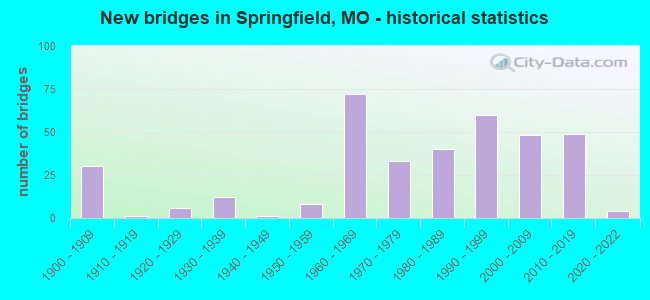
- New bridges - historical statistics
- 301900-1909
- 11910-1919
- 61920-1929
- 121930-1939
- 11940-1949
- 81950-1959
- 721960-1969
- 331970-1979
- 401980-1989
- 601990-1999
- 482000-2009
- 492010-2019
- 42020-2022
FCC Registered Antenna Towers: 739 (See the full list of FCC Registered Antenna Towers)
FCC Registered Commercial Land Mobile Towers: 12 (See the full list of FCC Registered Commercial Land Mobile Towers in Springfield, MO)
FCC Registered Private Land Mobile Towers: 16 (See the full list of FCC Registered Private Land Mobile Towers)
FCC Registered Broadcast Land Mobile Towers: 216 (See the full list of FCC Registered Broadcast Land Mobile Towers)
FCC Registered Microwave Towers: 116 (See the full list of FCC Registered Microwave Towers in this town)
FCC Registered Paging Towers: 39 (See the full list of FCC Registered Paging Towers)
FCC Registered Maritime Coast & Aviation Ground Towers: 21 (See the full list of FCC Registered Maritime Coast & Aviation Ground Towers)
FCC Registered Amateur Radio Licenses: 1,437 (See the full list of FCC Registered Amateur Radio Licenses in Springfield)
FAA Registered Aircraft Manufacturers and Dealers: 16 (See the full list of FAA Registered Manufacturers and Dealers in Springfield)
FAA Registered Aircraft: 183 (See the full list of FAA Registered Aircraft)
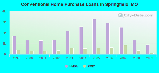
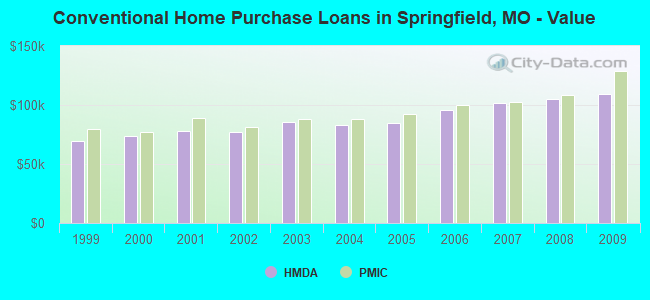
| Home Mortgage Disclosure Act Aggregated Statistics For Year 2009 (Based on 35 full and 11 partial tracts) | ||||||||||||||
| A) FHA, FSA/RHS & VA Home Purchase Loans | B) Conventional Home Purchase Loans | C) Refinancings | D) Home Improvement Loans | E) Loans on Dwellings For 5+ Families | F) Non-occupant Loans on < 5 Family Dwellings (A B C & D) | G) Loans On Manufactured Home Dwelling (A B C & D) | ||||||||
|---|---|---|---|---|---|---|---|---|---|---|---|---|---|---|
| Number | Average Value | Number | Average Value | Number | Average Value | Number | Average Value | Number | Average Value | Number | Average Value | Number | Average Value | |
| LOANS ORIGINATED | 818 | $97,677 | 899 | $109,729 | 2,635 | $125,436 | 133 | $39,786 | 28 | $882,360 | 649 | $92,985 | 6 | $12,688 |
| APPLICATIONS APPROVED, NOT ACCEPTED | 29 | $111,854 | 33 | $138,624 | 209 | $117,641 | 13 | $12,425 | 0 | $0 | 16 | $60,858 | 2 | $27,285 |
| APPLICATIONS DENIED | 103 | $92,933 | 106 | $84,136 | 727 | $103,849 | 78 | $45,576 | 1 | $851,650 | 83 | $72,353 | 5 | $63,900 |
| APPLICATIONS WITHDRAWN | 75 | $95,245 | 101 | $105,503 | 519 | $118,903 | 18 | $50,454 | 0 | $0 | 41 | $89,008 | 0 | $0 |
| FILES CLOSED FOR INCOMPLETENESS | 4 | $108,665 | 8 | $73,134 | 106 | $110,281 | 1 | $77,440 | 0 | $0 | 7 | $63,217 | 0 | $0 |
Detailed mortgage data for all 47 tracts in Springfield, MO
| Private Mortgage Insurance Companies Aggregated Statistics For Year 2009 (Based on 34 full and 11 partial tracts) | ||||||
| A) Conventional Home Purchase Loans | B) Refinancings | C) Non-occupant Loans on < 5 Family Dwellings (A & B) | ||||
|---|---|---|---|---|---|---|
| Number | Average Value | Number | Average Value | Number | Average Value | |
| LOANS ORIGINATED | 128 | $128,469 | 124 | $132,382 | 1 | $89,000 |
| APPLICATIONS APPROVED, NOT ACCEPTED | 22 | $143,543 | 32 | $145,107 | 1 | $99,000 |
| APPLICATIONS DENIED | 20 | $119,546 | 22 | $157,960 | 0 | $0 |
| APPLICATIONS WITHDRAWN | 7 | $114,687 | 6 | $126,000 | 0 | $0 |
| FILES CLOSED FOR INCOMPLETENESS | 5 | $137,204 | 4 | $149,182 | 0 | $0 |
2002 - 2018 National Fire Incident Reporting System (NFIRS) incidents
- Fire incident types reported to NFIRS in Springfield, MO
- 7,70845.9%Outside Fires
- 5,61333.4%Structure Fires
- 2,61415.6%Mobile Property/Vehicle Fires
- 8535.1%Other
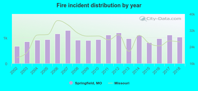 According to the data from the years 2002 - 2018 the average number of fires per year is 988. The highest number of reported fires - 1,279 took place in 2007, and the least - 669 in 2002. The data has a rising trend.
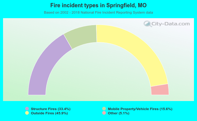 When looking into fire subcategories, the most reports belonged to: Outside Fires (45.9%), and Structure Fires (33.4%).
Fire-safe hotels and motels in Springfield, Missouri:
- Econo Lodge-east, 2611 N Glenstone, Springfield, Missouri 65803 , Phone: (417) 864-3565, Fax: (417) 865-0567
- Arbor Suites At The Mall, 1550 E Raynell Pl, Springfield, Missouri 65804 , Phone: (417) 887-8383, Fax: (417) 520-7900
- Americas Best Value Inn, 2355 N Glenstone, Springfield, Missouri 65803 , Phone: (417) 866-6776, Fax: (417) 863-9347
- Days Inn, 2700 N Glenstone, Springfield, Missouri 65803 , Phone: (417) 865-5511, Fax: (417) 865-5511
- Greenstay Hotel & Suites, 222 N Ingram Ml Rd, Springfield, Missouri 65804 , Phone: (417) 863-1440
- Holiday Inn Hotel & Suites, 2720 N Glenstone, Springfield, Missouri 65803 , Phone: (417) 865-8600, Fax: (417) 862-9415
- Lamplighter Inn & Suites, 1772 S Glenstone, Springfield, Missouri 65804 , Phone: (417) 882-1113, Fax: (417) 882-8869
- Clarion Hotel, 3333 S Glenstone, Springfield, Missouri 65804 , Phone: (417) 883-6550, Fax: (417) 883-5720
- 40 other hotels and motels
| Most common first names in Springfield, MO among deceased individuals | ||
| Name | Count | Lived (average) |
|---|---|---|
| Mary | 1,261 | 79.7 years |
| William | 1,188 | 75.5 years |
| James | 1,106 | 72.5 years |
| John | 1,052 | 75.0 years |
| Robert | 774 | 71.5 years |
| Charles | 771 | 74.7 years |
| George | 542 | 75.9 years |
| Helen | 535 | 80.3 years |
| Dorothy | 468 | 79.0 years |
| Ruth | 450 | 80.5 years |
| Most common last names in Springfield, MO among deceased individuals | ||
| Last name | Count | Lived (average) |
|---|---|---|
| Smith | 636 | 76.5 years |
| Johnson | 414 | 75.1 years |
| Jones | 396 | 77.2 years |
| Williams | 396 | 75.0 years |
| Miller | 319 | 77.5 years |
| Davis | 309 | 76.5 years |
| Brown | 290 | 76.1 years |
| Wilson | 247 | 76.3 years |
| Anderson | 239 | 78.0 years |
| Moore | 219 | 76.5 years |
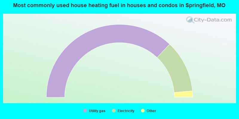
- 74.1%Utility gas
- 23.2%Electricity
- 1.4%Bottled, tank, or LP gas
- 0.7%Wood
- 0.4%Solar energy
- 0.2%No fuel used
- 0.1%Other fuel
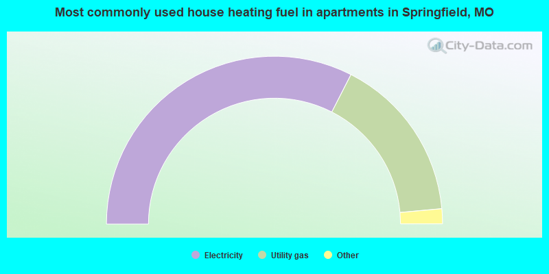
- 65.1%Electricity
- 32.1%Utility gas
- 1.9%Bottled, tank, or LP gas
- 0.5%No fuel used
- 0.2%Other fuel
- 0.1%Wood
Springfield compared to Missouri state average:
- Unemployed percentage below state average.
- Black race population percentage below state average.
- Renting percentage above state average.
- Length of stay since moving in below state average.
- Number of college students above state average.
Springfield, MO compared to other similar cities:
Springfield on our top lists:
- #3 on the list of "Top 101 cities with the highest number of thefts per 100,000 residents, excludes tourist destinations and others with a lot of outsiders visiting based on city industries data (population 50,000+)"
- #8 on the list of "Top 100 least-safe cities (highest city-data.com crime index) (pop. 50,000+)"
- #16 on the list of "Top 101 cities with the largest city-data.com crime index increase from 2002 to 2012 (population 50,000+)"
- #20 on the list of "Top 101 cities with the highest number of rapes per 100,000 residents, excludes tourist destinations and others with a lot of outsiders visiting based on city industries data (population 50,000+)"
- #23 on the list of "Top 101 cities with largest percentage of males in industries: accommodation and food services (population 50,000+)"
- #23 on the list of "Top 101 cities with the highest city-data.com crime index, excludes tourist destinations and others with a lot of outsiders visiting based on city industries data (population 50,000+)"
- #28 on the list of "Top 101 cities with largest percentage of males in industries: retail trade (population 50,000+)"
- #31 on the list of "Top 101 cities with largest percentage of males in occupations: food preparation and serving related occupations (population 50,000+)"
- #38 on the list of "Top 101 cities with the lowest percentage of family households, population 100,000+"
- #45 on the list of "Top 101 cities with the highest number of assaults per 100,000 residents, excludes tourist destinations and others with a lot of outsiders visiting based on city industries data (population 50,000+)"
- #48 on the list of "Top 101 cities with largest percentage of males in occupations: office and administrative support occupations (population 50,000+)"
- #51 on the list of "Top 101 cities with largest percentage of females in occupations: construction and extraction occupations (population 50,000+)"
- #54 on the list of "Top 101 cities with the largest city-data.com crime index per police officer (population 50,000+)"
- #58 on the list of "Top 101 cities that people commute into (largest positive percentage daily daytime population change due to commuting) (population 50,000+)"
- #59 on the list of "Top 101 larger cities with the largest decrease or smallest increase in household income from 2000 (population 50,000+)"
- #59 on the list of "Top 101 cities with the highest percentage of English-only speaking households, population 50,000+"
- #64 on the list of "Top 101 cities with the largest percentage of people in federal prisons and detention centers (population 1,000+)"
- #64 on the list of "Top 101 cities with the largest wind speed differences during a year (population 50,000+)"
- #67 on the list of "Top 100 cities with strongest arts, entertainment, recreation, accommodation and food services industries (pop. 50,000+)"
- #69 on the list of "Top 101 cities with the highest number of auto thefts per 100,000 residents, excludes tourist destinations and others with a lot of outsiders visiting based on city industries data (population 50,000+)"
- #46 (65804) on the list of "Top 101 zip codes with the most beauty salons in 2005"
- #66 (65803) on the list of "Top 101 zip codes with the most hotels or motels in 2005"
- #72 (65804) on the list of "Top 101 zip codes with the most finance and insurance companies in 2005"
- #85 (65806) on the list of "Top 101 zip codes with the lowest average reported salary/wage in 2012 (pop 5,000+)"
- #27 on the list of "Top 101 counties with the highest Ozone (1-hour) air pollution readings in 2012 (ppm)"
- #49 on the list of "Top 101 counties with the largest increase in the number of births per 1000 residents 2000-2006 to 2007-2013 (pop 50,000+)"
- #76 on the list of "Top 101 counties with the most Evangelical Protestant adherents"
- #80 on the list of "Top 101 counties with the lowest percentage of residents relocating from foreign countries between 2010 and 2011"
- #98 on the list of "Top 101 counties with the most Evangelical Protestant congregations (pop. 50,000+)"

|
|
Total of 235 patent applications in 2008-2024.