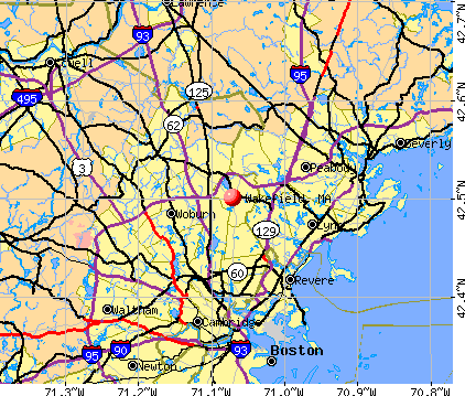
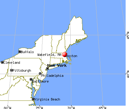
Wakefield, Massachusetts

Wakefield: Minuteman Statue on the Wakefield Common
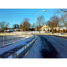
Wakefield: Main Street around Beebe Cove
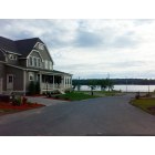
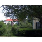
Wakefield: House and Lake
Wakefield: Fourth of July decorations in Wakefield.
Wakefield: Sailboats seen from a Wakefield street
Wakefield: Corner of Chestnut St and Prospect St
Wakefield: Downtown fountain and statue.
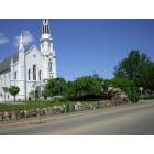
Wakefield: Rockery & First Baptist Church
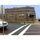
Wakefield: Wakefield Daily Item building. This is where the town's daily newspaper is published and printed.
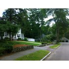
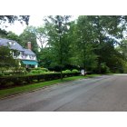
Wakefield: Wakefield homes.
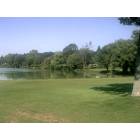
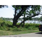
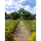
Wakefield: Lower Common by the Lake
- see
18
more - add
your
Submit your own pictures of this place and show them to the world
- OSM Map
- General Map
- Google Map
- MSN Map
Population change since 2000: +0.5%
| Males: 12,450 | |
| Females: 12,482 |
| Median resident age: | 43.9 years |
| Massachusetts median age: | 40.3 years |
Zip codes: 01880.
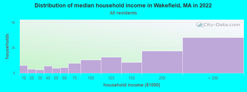
| Wakefield: | $122,999 |
| MA: | $94,488 |
Estimated per capita income in 2022: $65,573 (it was $30,369 in 2000)
Wakefield CDP income, earnings, and wages data
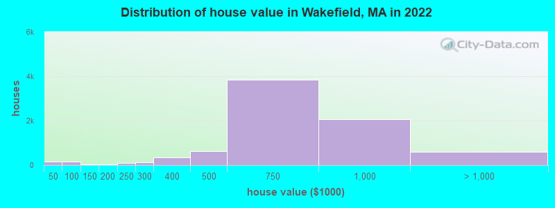
Estimated median house or condo value in 2022: $682,459 (it was $240,300 in 2000)
| Wakefield: | $682,459 |
| MA: | $534,700 |
Mean prices in 2022: all housing units: $675,078; detached houses: $718,349; townhouses or other attached units: $735,998; in 2-unit structures: $584,179; in 3-to-4-unit structures: $384,556; in 5-or-more-unit structures: $456,674
Median gross rent in 2022: $1,735.
(3.4% for White Non-Hispanic residents, 7.0% for Black residents, 22.7% for Hispanic or Latino residents, 36.1% for other race residents, 14.9% for two or more races residents)
Detailed information about poverty and poor residents in Wakefield, MA


Compare current foreclosures near Wakefield, MA:
| Photo | Address | Area | Beds / Baths | Price | Details |
|---|---|---|---|---|---|

|
#1
Bugli Ln
Wakefield, MA 01880
|
2,280 sq. feet
|
2 baths 4 beds |
show details | |

|
#2
Catalpa St
Wakefield, MA 01880
|
1,650 sq. feet
|
2 baths 3 beds |
show details | |

|
#3
Salem St
Wakefield, MA 01880
|
1,927 sq. feet
|
2 baths 3 beds |
show details | |

|
#4
Park St
Wakefield, MA 01880
|
2,518 sq. feet
|
2 baths 2 beds |
show details | |

|
#5
Preston St Apt 9b
Wakefield, MA 01880
|
780 sq. feet
|
1 baths 2 beds |
show details | |

|
#6
Millbrook Ln
Wakefield, MA 01880
|
2,224 sq. feet
|
2 baths 4 beds |
show details | |

|
#7
1/2 Eaton Ave
Wakefield, MA 01880
|
- sq. feet
|
- baths - beds |
show details | |

|
#8
Audubon Rd Apt 504
Wakefield, MA 01880
|
- sq. feet
|
- baths - beds |
show details | |

|
#9
Salem St
Wakefield, MA 01880
|
- sq. feet
|
- baths - beds |
show details | |

|
#10
Maple St
Tewksbury, MA 01876
|
1,748 sq. feet
|
1 baths 4 beds |
$379,900
|
show details |
| Photo | Address | Area | Beds / Baths | Price | Details |
|---|---|---|---|---|---|

|
#11
Commonwealth Ave Apt B
Boston, MA 02116
|
- sq. feet
|
1 baths 2 beds |
$684,900
|
show details |

|
#12
Portland St
Lynn, MA 01902
|
851 sq. feet
|
2 baths 2 beds |
show details | |

|
#13
Church St
Boston, MA 02122
|
3,663 sq. feet
|
3 baths 6 beds |
show details | |

|
#14
Aiken Ave Apt 15
Lowell, MA 01850
|
1,100 sq. feet
|
1 baths 2 beds |
show details | |

|
#15
Salem Rd
Billerica, MA 01821
|
1,428 sq. feet
|
1 baths 4 beds |
show details | |

|
#16
Brahms St
Roslindale, MA 02131
|
1,604 sq. feet
|
1 baths 4 beds |
show details | |

|
#17
Baker St
West Roxbury, MA 02132
|
2,614 sq. feet
|
3 baths 4 beds |
show details | |

|
#18
Naugus Ave
Marblehead, MA 01945
|
1,544 sq. feet
|
1 baths 3 beds |
show details | |

|
#19
Gordon St
Allston, MA 02134
|
3,246 sq. feet
|
2 baths 5 beds |
show details | |

|
#20
College Farm Rd
Waltham, MA 02451
|
879 sq. feet
|
1 baths 2 beds |
show details |
| Photo | Address | Area | Beds / Baths | Price | Details |
|---|---|---|---|---|---|

|
#21
Atlantic Street, Unit A 10 A/k/a Unit 10, Marilyn Condominium
Lynn, MA 01902
|
576 sq. feet
|
1 baths 1 beds |
show details | |

|
#22
Lincoln Ave
Saugus, MA 01906
|
1,080 sq. feet
|
1 baths 3 beds |
show details | |

|
#23
Essex St
Swampscott, MA 01907
|
2,029 sq. feet
|
2 baths 3 beds |
show details | |

|
#24
Iroquois St
Boston, MA 02120
|
2,524 sq. feet
|
1 baths 4 beds |
show details | |

|
#25
Merrill Ave
Lynn, MA 01902
|
1,136 sq. feet
|
1 baths 3 beds |
show details | |

|
#26
Salem St
North Andover, MA 01845
|
1,572 sq. feet
|
1 baths 2 beds |
show details | |

|
#27
Magnolia St
Boston, MA 02125
|
3,654 sq. feet
|
3 baths 6 beds |
show details | |

|
#28
Marden Ave # 6
Boston, MA 02124
|
1,639 sq. feet
|
1 baths 3 beds |
show details | |

|
#29
Carlisle St
Lowell, MA 01852
|
1,913 sq. feet
|
1 baths 5 beds |
show details | |

|
#30
Boston Rd
Chelmsford, MA 01824
|
1,392 sq. feet
|
1 baths 3 beds |
show details |
| Photo | Address | Area | Beds / Baths | Price | Details |
|---|---|---|---|---|---|

|
#31
Bloomfield St
Boston, MA 02124
|
2,667 sq. feet
|
2 baths 6 beds |
show details | |

|
#32
Forest Park Rd
Woburn, MA 01801
|
1,132 sq. feet
|
1 baths 3 beds |
show details | |

|
#33
S Broadway
Lawrence, MA 01843
|
5,706 sq. feet
|
2 baths 6 beds |
show details | |

|
#34
Cora St
Winthrop, MA 02152
|
1,452 sq. feet
|
1 baths 2 beds |
show details | |

|
#35
Emily Rd
Tewksbury, MA 01876
|
1,600 sq. feet
|
1 baths 3 beds |
show details | |

|
#36
Old Planters Rd
Beverly, MA 01915
|
3,612 sq. feet
|
3 baths 4 beds |
show details | |

|
#37
Wakullah St
Boston, MA 02119
|
2,494 sq. feet
|
2 baths 5 beds |
show details | |

|
#38
Columbus Ave
Waltham, MA 02451
|
3,586 sq. feet
|
1 baths 5 beds |
show details | |

|
#39
Gay Head St
Jamaica Plain, MA 02130
|
1,236 sq. feet
|
2 baths 3 beds |
show details | |

|
#40
Bruce Ln # 2458
Newton, MA 02458
|
3,030 sq. feet
|
3 baths 4 beds |
show details |
| Photo | Address | Area | Beds / Baths | Price | Details |
|---|---|---|---|---|---|

|
#41
Batchelder St
Boston, MA 02125
|
1,637 sq. feet
|
2 baths 5 beds |
show details | |

|
#42
Charles Dr
Tewksbury, MA 01876
|
1,092 sq. feet
|
1 baths 3 beds |
show details | |

|
#43
Fox Run Dr
Tewksbury, MA 01876
|
2,120 sq. feet
|
2 baths 4 beds |
show details | |

|
#44
Dacia St
Boston, MA 02125
|
1,524 sq. feet
|
2 baths 3 beds |
show details | |

|
#45
Eddy St
Waltham, MA 02453
|
2,504 sq. feet
|
2 baths 4 beds |
show details | |

|
#46
Otter Cir
Billerica, MA 01821
|
3,638 sq. feet
|
2 baths 4 beds |
show details | |

|
#47
Highland St
Boston, MA 02119
|
2,634 sq. feet
|
2 baths 8 beds |
show details | |

|
#48
W Walnut Pk
Boston, MA 02119
|
2,948 sq. feet
|
2 baths 4 beds |
show details | |

|
#49
Harold Pl
Tewksbury, MA 01876
|
3,574 sq. feet
|
3 baths 4 beds |
show details | |

|
Check over 1 million property listings on Foreclosure.com!
|
browse all offers | |||


- 23,08085.6%White alone
- 1,1434.2%Asian alone
- 1,0623.9%Two or more races
- 7512.8%Hispanic
- 2651.0%Black alone
- 940.3%Other race alone

Races in Wakefield detailed stats: ancestries, foreign born residents, place of birth
According to our research of Massachusetts and other state lists, there were 4 registered sex offenders living in Wakefield, Massachusetts as of April 24, 2024.
The ratio of all residents to sex offenders in Wakefield is 6,693 to 1.
The ratio of registered sex offenders to all residents in this city is much lower than the state average.
Type |
2009 |
2010 |
2011 |
2012 |
2013 |
2014 |
2015 |
2016 |
2017 |
2018 |
2019 |
2020 |
2021 |
2022 |
|---|---|---|---|---|---|---|---|---|---|---|---|---|---|---|
| Murders (per 100,000) | 1 (4.0) | 0 (0.0) | 1 (4.0) | 0 (0.0) | 0 (0.0) | 0 (0.0) | 2 (7.4) | 0 (0.0) | 0 (0.0) | 0 (0.0) | 0 (0.0) | 0 (0.0) | 1 (3.6) | 0 (0.0) |
| Rapes (per 100,000) | 9 (35.9) | 3 (12.0) | 5 (19.9) | 3 (11.8) | 11 (42.6) | 5 (18.9) | 8 (29.4) | 9 (33.2) | 5 (18.5) | 13 (47.4) | 3 (11.0) | 4 (14.8) | 6 (21.8) | 8 (29.3) |
| Robberies (per 100,000) | 5 (20.0) | 9 (36.1) | 7 (27.9) | 8 (31.5) | 1 (3.9) | 6 (22.7) | 4 (14.7) | 7 (25.8) | 3 (11.1) | 5 (18.2) | 3 (11.0) | 2 (7.4) | 0 (0.0) | 4 (14.7) |
| Assaults (per 100,000) | 45 (179.6) | 49 (196.5) | 48 (191.4) | 56 (220.3) | 37 (143.2) | 32 (121.2) | 40 (147.0) | 45 (166.2) | 38 (140.5) | 25 (91.1) | 31 (114.1) | 23 (84.8) | 24 (87.4) | 29 (106.4) |
| Burglaries (per 100,000) | 79 (315.3) | 76 (304.8) | 68 (271.1) | 70 (275.4) | 66 (255.4) | 51 (193.2) | 47 (172.8) | 27 (99.7) | 36 (133.1) | 15 (54.7) | 25 (92.0) | 25 (92.2) | 13 (47.3) | 11 (40.3) |
| Thefts (per 100,000) | 226 (901.9) | 209 (838.3) | 220 (877.1) | 223 (877.4) | 233 (901.8) | 218 (825.9) | 144 (529.3) | 169 (624.1) | 150 (554.5) | 152 (553.8) | 128 (471.0) | 124 (457.3) | 70 (254.8) | 87 (319.1) |
| Auto thefts (per 100,000) | 18 (71.8) | 16 (64.2) | 16 (63.8) | 16 (63.0) | 14 (54.2) | 9 (34.1) | 17 (62.5) | 14 (51.7) | 9 (33.3) | 8 (29.1) | 12 (44.2) | 9 (33.2) | 9 (32.8) | 22 (80.7) |
| Arson (per 100,000) | 2 (8.0) | 4 (16.0) | 0 (0.0) | 1 (3.9) | 0 (0.0) | 1 (3.8) | 0 (0.0) | 2 (7.4) | 0 (0.0) | 1 (3.6) | 0 (0.0) | 1 (3.7) | 2 (7.3) | 1 (3.7) |
| City-Data.com crime index | 142.5 | 119.8 | 129.7 | 122.4 | 122.1 | 95.5 | 110.3 | 103.7 | 80.4 | 89.9 | 63.8 | 58.4 | 58.4 | 71.2 |
The City-Data.com crime index weighs serious crimes and violent crimes more heavily. Higher means more crime, U.S. average is 246.1. It adjusts for the number of visitors and daily workers commuting into cities.

Crime rate in Wakefield detailed stats: murders, rapes, robberies, assaults, burglaries, thefts, arson
Full-time law enforcement employees in 2021, including police officers: 48 (47 officers - 42 male; 5 female).
| Officers per 1,000 residents here: | 1.71 |
| Massachusetts average: | 2.53 |
 Recent articles from our blog. Our writers, many of them Ph.D. graduates or candidates, create easy-to-read articles on a wide variety of topics.

 | Wakefield (vs Reading) (34 replies) |
| Wakefield, MA... thoughts? (9 replies) |
| Possibly moving to Boston (wakefield) (11 replies) |
| Town in Massachusetts You’d Least Like To Live In? (179 replies) |
| Wakefield and Reading commuter rail parking lot (4 replies) |
| Woburn, Wakefield, Burlington, Beverly? SFH (14 replies) |
Latest news from Wakefield, MA collected exclusively by city-data.com from local newspapers, TV, and radio stations
Ancestries: Italian (25.9%), Irish (23.9%), American (5.2%), English (4.9%), Polish (3.1%), French Canadian (2.1%).
Current Local Time: EST time zone
Incorporated in 1812
Elevation: 100 feet
Land area: 7.47 square miles.
Population density: 3,339 people per square mile (average).
2,545 residents are foreign born (3.6% Asia, 2.5% Europe, 1.8% Latin America).
| This place: | 9.4% |
| Massachusetts: | 17.6% |
Median real estate property taxes paid for housing units with mortgages in 2022: $6,714 (1.0%)
Median real estate property taxes paid for housing units with no mortgage in 2022: $7,039 (1.0%)
Nearest city with pop. 50,000+: Malden, MA  (5.1 miles , pop. 56,340).
Nearest city with pop. 200,000+: Boston, MA (12.5 miles , pop. 589,141).
Nearest city with pop. 1,000,000+: Bronx, NY (184.5 miles , pop. 1,332,650).
Nearest cities:
Latitude: 42.50 N, Longitude: 71.07 W
Daytime population change due to commuting: -415 (-1.5%)
Workers who live and work in this place: 5,213 (35.7%)
Area codes: 781, 339
Wakefield, Massachusetts accommodation & food services, waste management - Economy and Business Data
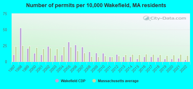
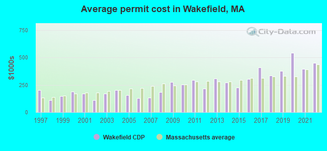
Single-family new house construction building permits:
- 2022: 8 buildings, average cost: $451,800
- 2021: 14 buildings, average cost: $397,200
- 2020: 12 buildings, average cost: $543,800
- 2019: 11 buildings, average cost: $375,800
- 2018: 17 buildings, average cost: $336,800
- 2017: 19 buildings, average cost: $407,900
- 2016: 20 buildings, average cost: $303,800
- 2015: 12 buildings, average cost: $223,800
- 2014: 19 buildings, average cost: $271,000
- 2013: 20 buildings, average cost: $307,800
- 2012: 29 buildings, average cost: $214,600
- 2011: 20 buildings, average cost: $295,900
- 2010: 33 buildings, average cost: $251,200
- 2009: 35 buildings, average cost: $273,500
- 2008: 39 buildings, average cost: $185,900
- 2007: 57 buildings, average cost: $134,800
- 2006: 66 buildings, average cost: $127,100
- 2005: 77 buildings, average cost: $157,200
- 2004: 26 buildings, average cost: $203,200
- 2003: 25 buildings, average cost: $172,200
- 2002: 60 buildings, average cost: $110,100
- 2001: 28 buildings, average cost: $171,100
- 2000: 33 buildings, average cost: $187,400
- 1999: 52 buildings, average cost: $144,900
- 1998: 131 buildings, average cost: $111,400
- 1997: 27 buildings, average cost: $202,300
| Here: | 3.0% |
| Massachusetts: | 3.5% |
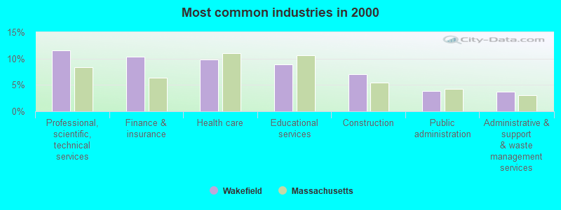
- Professional, scientific, technical services (11.6%)
- Finance & insurance (10.3%)
- Health care (9.8%)
- Educational services (8.9%)
- Construction (7.0%)
- Public administration (3.9%)
- Administrative & support & waste management services (3.7%)
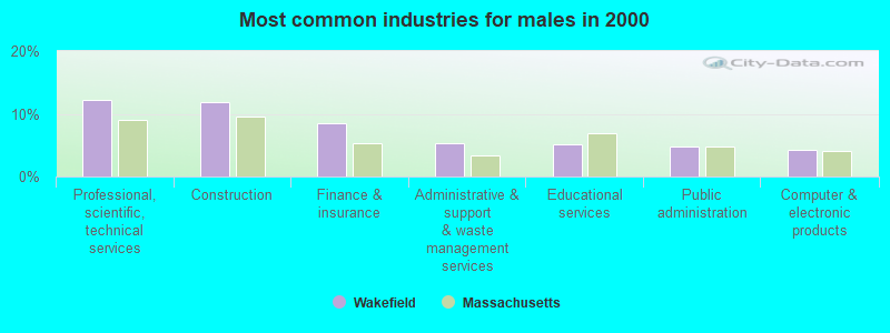
- Professional, scientific, technical services (12.3%)
- Construction (11.9%)
- Finance & insurance (8.6%)
- Administrative & support & waste management services (5.3%)
- Educational services (5.1%)
- Public administration (4.8%)
- Computer & electronic products (4.2%)
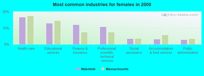
- Health care (16.7%)
- Educational services (13.0%)
- Finance & insurance (12.1%)
- Professional, scientific, technical services (10.9%)
- Social assistance (3.5%)
- Accommodation & food services (3.3%)
- Public administration (2.9%)
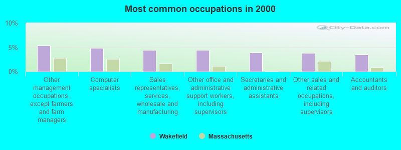
- Other management occupations, except farmers and farm managers (5.3%)
- Computer specialists (4.9%)
- Sales representatives, services, wholesale and manufacturing (4.4%)
- Other office and administrative support workers, including supervisors (4.4%)
- Secretaries and administrative assistants (3.9%)
- Other sales and related occupations, including supervisors (3.8%)
- Accountants and auditors (3.5%)
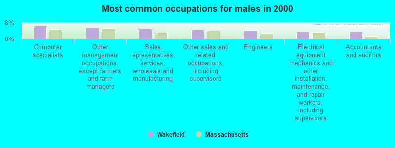
- Computer specialists (6.5%)
- Other management occupations, except farmers and farm managers (5.6%)
- Sales representatives, services, wholesale and manufacturing (5.2%)
- Other sales and related occupations, including supervisors (4.7%)
- Engineers (4.3%)
- Electrical equipment mechanics and other installation, maintenance, and repair workers, including supervisors (3.6%)
- Accountants and auditors (3.6%)
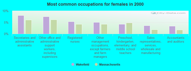
- Secretaries and administrative assistants (8.0%)
- Other office and administrative support workers, including supervisors (7.6%)
- Registered nurses (5.4%)
- Other management occupations, except farmers and farm managers (5.0%)
- Preschool, kindergarten, elementary, and middle school teachers (4.3%)
- Sales representatives, services, wholesale and manufacturing (3.7%)
- Accountants and auditors (3.4%)
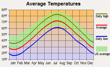
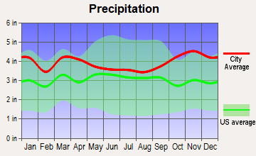
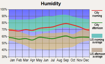
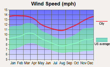
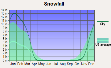
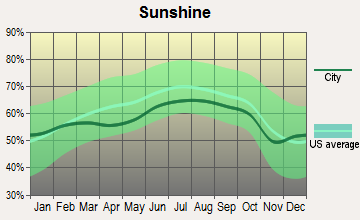
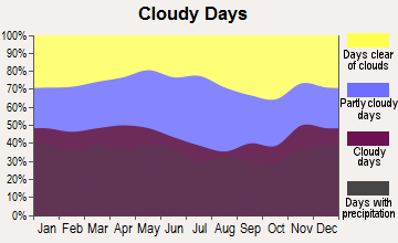
Average climate in Wakefield, Massachusetts
Based on data reported by over 4,000 weather stations
|
|


(lower is better)
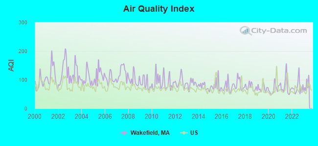
Air Quality Index (AQI) level in 2022 was 74.3. This is about average.
| City: | 74.3 |
| U.S.: | 72.6 |

Carbon Monoxide (CO) [ppm] level in 2022 was 0.266. This is about average. Closest monitor was 6.7 miles away from the city center.
| City: | 0.266 |
| U.S.: | 0.251 |
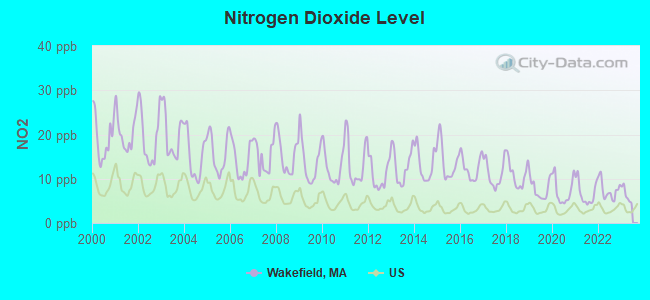
Nitrogen Dioxide (NO2) [ppb] level in 2022 was 7.38. This is significantly worse than average. Closest monitor was 4.4 miles away from the city center.
| City: | 7.38 |
| U.S.: | 5.11 |
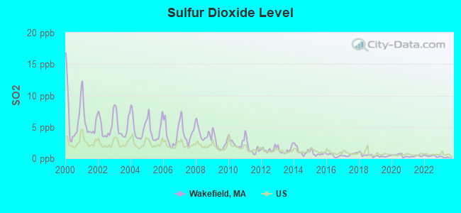
Sulfur Dioxide (SO2) [ppb] level in 2022 was 0.358. This is significantly better than average. Closest monitor was 2.7 miles away from the city center.
| City: | 0.358 |
| U.S.: | 1.515 |
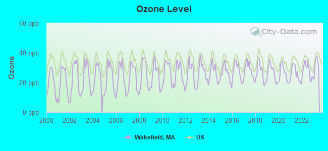
Ozone [ppb] level in 2022 was 28.2. This is about average. Closest monitor was 6.7 miles away from the city center.
| City: | 28.2 |
| U.S.: | 33.3 |
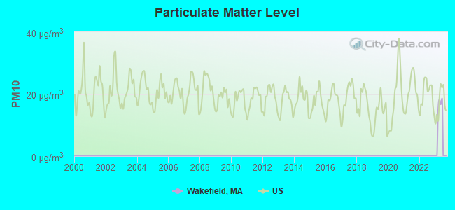
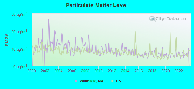
Particulate Matter (PM2.5) [µg/m3] level in 2022 was 6.49. This is better than average. Closest monitor was 5.4 miles away from the city center.
| City: | 6.49 |
| U.S.: | 8.11 |
Tornado activity:
Wakefield-area historical tornado activity is near Massachusetts state average. It is 43% smaller than the overall U.S. average.
On 6/9/1953, a category F4 (max. wind speeds 207-260 mph) tornado 26.8 miles away from the Wakefield place center killed 90 people and injured 1228 people and caused between $50,000,000 and $500,000,000 in damages.
On 9/29/1974, a category F3 (max. wind speeds 158-206 mph) tornado 10.5 miles away from the place center injured one person and caused between $50,000 and $500,000 in damages.
Earthquake activity:
Wakefield-area historical earthquake activity is significantly above Massachusetts state average. It is 73% smaller than the overall U.S. average.On 4/20/2002 at 10:50:47, a magnitude 5.3 (5.3 ML, Depth: 3.0 mi, Class: Moderate, Intensity: VI - VII) earthquake occurred 191.6 miles away from Wakefield center
On 10/7/1983 at 10:18:46, a magnitude 5.3 (5.1 MB, 5.3 LG, 5.1 ML) earthquake occurred 193.0 miles away from Wakefield center
On 1/19/1982 at 00:14:42, a magnitude 4.7 (4.5 MB, 4.7 MD, 4.5 LG, Class: Light, Intensity: IV - V) earthquake occurred 74.1 miles away from Wakefield center
On 10/16/2012 at 23:12:25, a magnitude 4.7 (4.7 ML, Depth: 10.0 mi) earthquake occurred 78.7 miles away from Wakefield center
On 4/20/2002 at 10:50:47, a magnitude 5.2 (5.2 MB, 4.2 MS, 5.2 MW, 5.0 MW) earthquake occurred 191.0 miles away from the city center
On 8/22/1992 at 12:20:32, a magnitude 4.8 (4.8 MB, 3.8 MS, 4.7 LG, Depth: 6.2 mi) earthquake occurred 238.1 miles away from the city center
Magnitude types: regional Lg-wave magnitude (LG), body-wave magnitude (MB), duration magnitude (MD), local magnitude (ML), surface-wave magnitude (MS), moment magnitude (MW)
Natural disasters:
The number of natural disasters in Middlesex County (31) is a lot greater than the US average (15).Major Disasters (Presidential) Declared: 17
Emergencies Declared: 14
Causes of natural disasters: Floods: 12, Storms: 9, Hurricanes: 6, Snowstorms: 6, Winter Storms: 5, Blizzards: 2, Snows: 2, Explosion: 1, Heavy Rain: 1, Snowfall: 1, Water Main Break: 1, Wind: 1 (Note: some incidents may be assigned to more than one category).
Main business address for: EDGEWATER TECHNOLOGY INC/DE/ (SERVICES-COMPUTER PROGRAMMING, DATA PROCESSING, ETC.), FRANKLIN STREET PROPERTIES CORP /MA/ (REAL ESTATE INVESTMENT TRUSTS), AMERICAN DENTAL PARTNERS INC (SERVICES-MISC HEALTH & ALLIED SERVICES, NEC).
Hospitals and medical centers in Wakefield:
- VNA OF MIDDLESEX EAST (607 NORTH AVENUE)
- GREENVIEW MANOR NURS HOME (BATHOL ST)
- GREENWOOD NURSING AND REHABILITATION CENTER (90 GREENWOOD STREET)
- GREENWOOD NURSING HOME (90 GREENWOOD ST)
- GUARDIAN NURSING HOME (105 CHESTNUT ST)
- KIRKWOOD NH - OLD (202 MAIN ST)
- WAKEFIELD CARE AND REHABILITATION CENTER (ONE BATHOL STREET)
Amtrak stations near Wakefield:
- 4 miles: WOBURN (100 ATLANTIC AVE.) . Services: ticket office.
- 10 miles: BOSTON, NORTH STATION (BOSTON, 126 CAUSEWAY ST.) . Services: ticket office, enclosed waiting area.
- 11 miles: BOSTON (SO. STA) (BOSTON, ATLANTIC AVE. & SUMMER ST.) . Services: ticket office, fully wheelchair accessible, enclosed waiting area, public restrooms, public payphones, full-service food facilities and snack bar, ATM, paid short-term parking, paid long-term parking, call for car rental service, taxi stand, intercity bus service, public transit connection.
Colleges/universities with over 2000 students nearest to Wakefield:
- Tufts University (about 8 miles; Medford, MA; Full-time enrollment: 9,041)
- North Shore Community College (about 9 miles; Danvers, MA; FT enrollment: 5,195)
- Bunker Hill Community College (about 9 miles; Boston, MA; FT enrollment: 8,814)
- Lesley University (about 9 miles; Cambridge, MA; FT enrollment: 4,317)
- Harvard University (about 10 miles; Cambridge, MA; FT enrollment: 20,857)
- Salem State University (about 10 miles; Salem, MA; FT enrollment: 8,027)
- Cambridge College (about 10 miles; Cambridge, MA; FT enrollment: 2,782)
Public high schools in Wakefield:
- NORTHEAST METRO REGIONAL VOCATIONAL (Students: 1,258, Location: 100 HEMLOCK RD, Grades: 9-12)
- WAKEFIELD MEMORIAL HIGH (Students: 1,006, Location: 60 FARM STREET, Grades: 9-12)
Private high school in Wakefield:
Public elementary/middle schools in Wakefield:
- WOODVILLE SCHOOL (Students: 497, Location: 30 FARM STREET, Grades: KG-4)
- DOLBEARE (Students: 474, Location: 340 LOWELL STREET, Grades: KG-4)
- GREENWOOD (Students: 270, Location: 1030 MAIN STREET, Grades: KG-4)
- WALTON (Students: 155, Location: 18 DAVIDSON ROAD, Grades: 1-4)
- GALVIN MIDDLE SCHOOL (Students: 109, Location: 525 MAIN STREET, Grades: 5-8)
Private elementary/middle schools in Wakefield:
- ST JOSEPH SCHOOL (Students: 212, Location: 15 GOULD ST, Grades: PK-8)
- ODYSSEY DAY SCHOOL (Students: 128, Location: 11 PAUL AVE, Grades: PK-8)
Points of interest:
Notable locations in Wakefield: Veterans Field (A), Lakeside Office Park (B), Wakefield Industrial Center (C), Center Depot (D), Wakefield Townhall (E), Wakefield Fire Department Station 2 (F), Wakefield Fire Department Station 1 Headquarters (G), Lucius Beebe Memorial Library (H), Wakefield Town Hall (I), YMCA (J). Display/hide their locations on the map
Main business address in Wakefield include: EDGEWATER TECHNOLOGY INC/DE/ (A), FRANKLIN STREET PROPERTIES CORP /MA/ (B), AMERICAN DENTAL PARTNERS INC (C). Display/hide their locations on the map
Churches in Wakefield include: Wakefield-Lynnfield United Church (A), Lakeside Cemetery Chapel (B), Hope Alliance Church (C), First Parish Congregational Church (D), Emmanuel Parish Church of Wakefield (E). Display/hide their locations on the map
Cemeteries: Temple Israel Cemetery (1), Old Cemetery (2), Forest Glade Cemetery (3), Lakeside Cemetery (4). Display/hide their locations on the map
Reservoirs: Crystal Lake (A), Lake Quannapowitt (B). Display/hide their locations on the map
Parks in Wakefield include: Common District (1), Sullivan Memorial Park (2), Wakefield Park (3), Church-Lafayette Streets Historic District (4), Veterans Field (5), Yale Avenue Historic District (6), Wakefield Town Forest Park (7), Crystal Lake Park (8), Moulten Playground (9). Display/hide their locations on the map
Tourist attractions: Wakefield Bowla Drome (Amusement & Theme Parks; 92 Water Street), Internet Construction Sites (Arcades & Amusements; 25 Bonair Avenue).
Hotels: J Witherspoons Grill & Pub (1 Audubon Road), Dockside Restaurant (1099 Main Street), Best Western Lord Wakefield (595 North Avenue), Colonial Golf Course & Driving Range (95 Audubon Road), Sheraton Colonial Hilton & Golf Club (1 Audubon Rd), Sheraton Colonial Hotel & Golf Club Bost (One Audubon Road).
Birthplace of: Lucius Beebe - Food writer, Tom Keady - Football, Albert P. Langtry - Politician, Carleton S. Coon - (died 1981), anthropologist, Geoff Useless - Singer-songwriter, Joe Cannata - Ice hockey player, John A. Volpe - Diplomat, C. Hartley Grattan - Economist, Andy Harrington (pitcher) - Baseball player, Greye La Spina - Fantasy writer.
Drinking water stations with addresses in Wakefield and their reported violations in the past:
WAKEFIELD WATER DEPT (Population served: 24,804, Surface water):Past monitoring violations:SHERWOOD FOREST SHORES WATER (Serves NH, Population served: 50, Groundwater):
- Monitoring and Reporting (DBP) - Between JAN-2011 and MAR-2011, Contaminant: Total Haloacetic Acids (HAA5). Follow-up actions: St AO (w/o penalty) issued (MAY-03-2011)
- Monitoring and Reporting (DBP) - Between JAN-2011 and MAR-2011, Contaminant: TTHM. Follow-up actions: St AO (w/o penalty) issued (MAY-03-2011)
- 39 regular monitoring violations
Past health violations:Past monitoring violations:
- MCL, Monthly (TCR) - Between JUL-2013 and SEP-2013, Contaminant: Coliform. Follow-up actions: St Public Notif requested (SEP-09-2013), St Violation/Reminder Notice (SEP-09-2013), St Public Notif received (SEP-27-2013)
- 3 routine major monitoring violations
| This place: | 2.5 people |
| Massachusetts: | 2.5 people |
| This place: | 65.5% |
| Whole state: | 63.0% |
| This place: | 5.7% |
| Whole state: | 7.0% |
Likely homosexual households (counted as self-reported same-sex unmarried-partner households)
- Lesbian couples: 0.6% of all households
- Gay men: 0.4% of all households
People in group quarters in Wakefield in 2010:
- 188 people in nursing facilities/skilled-nursing facilities
- 31 people in group homes intended for adults
- 14 people in residential treatment centers for adults
- 11 people in group homes for juveniles (non-correctional)
- 10 people in other noninstitutional facilities
People in group quarters in Wakefield in 2000:
- 199 people in nursing homes
- 20 people in homes for the mentally ill
- 14 people in training schools for juvenile delinquents
- 6 people in religious group quarters
- 4 people in homes for the physically handicapped
Banks with branches in Wakefield (2011 data):
- The Savings Bank: Main Street Branch, Lakeside Branch, High School Branch (Seasonal), at 357 Main Street. Info updated 2009/07/02: Bank assets: $443.8 mil, Deposits: $385.0 mil, local headquarters, positive income, 9 total offices
- Bank of America, National Association: Wakefield Branch at 2 Smith Street, branch established on 1972/05/27. Info updated 2009/11/18: Bank assets: $1,451,969.3 mil, Deposits: $1,077,176.8 mil, headquarters in Charlotte, NC, positive income, 5782 total offices, Holding Company: Bank Of America Corporation
- Sovereign Bank, National Association: Wakefield Branch at 369 Main Street, branch established on 1854/01/01. Info updated 2012/01/31: Bank assets: $78,146.9 mil, Deposits: $48,042.9 mil, headquarters in Wilmington, DE, positive income, Commercial Lending Specialization, 718 total offices, Holding Company: Banco Santander, S.A.
- Eastern Bank: Wakefield Branch at 445 Main Street, branch established on 1978/01/16. Info updated 2011/03/30: Bank assets: $7,812.9 mil, Deposits: $6,295.8 mil, headquarters in Boston, MA, positive income, Commercial Lending Specialization, 94 total offices, Holding Company: Eastern Bank Corporation
- Wakefield Co-operative Bank: Wakefield Co-Operative Bank at 342 Main Street, branch established on 1887/01/01. Info updated 2007/08/31: Bank assets: $154.1 mil, Deposits: $132.3 mil, local headquarters, positive income, Mortgage Lending Specialization, 2 total offices
- East Boston Savings Bank: Wakefield Branch at 381 Main Street, branch established on 2008/10/09. Info updated 2011/06/07: Bank assets: $1,946.5 mil, Deposits: $1,609.3 mil, headquarters in Boston, MA, positive income, Commercial Lending Specialization, 24 total offices, Holding Company: Meridian Financial Services, Inc
For population 15 years and over in Wakefield:

- Never married: 28.1%
- Now married: 55.1%
- Separated: 0.9%
- Widowed: 5.7%
- Divorced: 10.2%
For population 25 years and over in Wakefield:
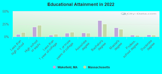
- High school or higher: 95.6%
- Bachelor's degree or higher: 56.9%
- Graduate or professional degree: 25.2%
- Unemployed: 3.1%
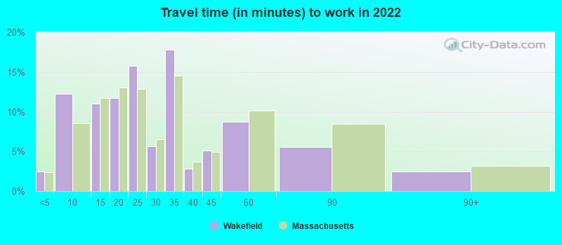
- Mean travel time to work (commute): 23.3 minutes
| Here: | 10.8 |
| Massachusetts average: | 13.0 |


Graphs represent county-level data. Detailed 2008 Election Results
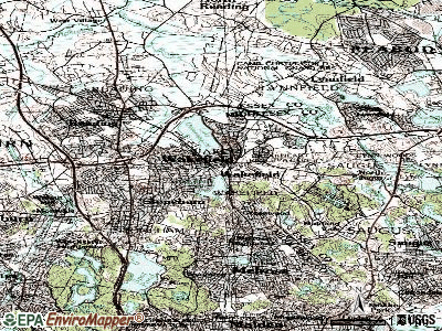
Neighborhoods in Wakefield:
(Wakefield, Massachusetts Neighborhood Map)Religion statistics for Wakefield, MA (based on Middlesex County data)


| Religion | Adherents | Congregations |
|---|---|---|
| Catholic | 718,209 | 107 |
| Mainline Protestant | 70,053 | 269 |
| Other | 68,480 | 199 |
| Evangelical Protestant | 41,270 | 304 |
| Orthodox | 23,641 | 28 |
| Black Protestant | 2,276 | 8 |
| None | 579,156 | - |
Food Environment Statistics:
| Middlesex County: | 1.71 / 10,000 pop. |
| State: | 1.98 / 10,000 pop. |
| This county: | 0.03 / 10,000 pop. |
| Massachusetts: | 0.05 / 10,000 pop. |
| This county: | 2.14 / 10,000 pop. |
| Massachusetts: | 2.22 / 10,000 pop. |
| Here: | 1.38 / 10,000 pop. |
| Massachusetts: | 1.77 / 10,000 pop. |
| This county: | 7.84 / 10,000 pop. |
| Massachusetts: | 8.76 / 10,000 pop. |
| Middlesex County: | 7.8% |
| Massachusetts: | 8.1% |
| Middlesex County: | 21.5% |
| Massachusetts: | 22.5% |
| Middlesex County: | 18.0% |
| State: | 16.5% |
Health and Nutrition:
| This city: | 54.8% |
| Massachusetts: | 50.5% |
| Wakefield: | 53.8% |
| Massachusetts: | 48.0% |
| This city: | 28.0 |
| State: | 28.4 |
| This city: | 18.9% |
| Massachusetts: | 20.7% |
| This city: | 8.3% |
| Massachusetts: | 10.4% |
| This city: | 7.0 |
| Massachusetts: | 6.8 |
| Wakefield: | 33.2% |
| Massachusetts: | 33.4% |
| This city: | 60.9% |
| Massachusetts: | 57.1% |
| Wakefield: | 80.1% |
| Massachusetts: | 79.2% |
More about Health and Nutrition of Wakefield, MA Residents
6.91% of this county's 2021 resident taxpayers lived in other counties in 2020 ($102,955 average adjusted gross income)
| Here: | 6.91% |
| Massachusetts average: | 6.35% |
0.01% of residents moved from foreign countries ($137 average AGI)
Middlesex County: 0.01% Massachusetts average: 0.01%
Top counties from which taxpayers relocated into this county between 2020 and 2021:
| from Suffolk County, MA | |
| from Essex County, MA | |
| from Norfolk County, MA |
8.22% of this county's 2020 resident taxpayers moved to other counties in 2021 ($123,369 average adjusted gross income)
| Here: | 8.22% |
| Massachusetts average: | 7.18% |
0.01% of residents moved to foreign countries ($124 average AGI)
Middlesex County: 0.01% Massachusetts average: 0.02%
Top counties to which taxpayers relocated from this county between 2020 and 2021:
| to Suffolk County, MA | |
| to Essex County, MA | |
| to Worcester County, MA |
| Businesses in Wakefield, MA | ||||
| Name | Count | Name | Count | |
|---|---|---|---|---|
| 7-Eleven | 1 | MasterBrand Cabinets | 2 | |
| Ace Hardware | 1 | Mazda | 1 | |
| CVS | 1 | McDonald's | 1 | |
| Chevrolet | 1 | Shaw's | 1 | |
| Circle K | 2 | Sheraton | 1 | |
| Decora Cabinetry | 2 | Subaru | 1 | |
| Dunkin Donuts | 4 | Subway | 1 | |
| FedEx | 8 | UPS | 10 | |
Strongest AM radio stations in Wakefield:
- WRKO (680 AM; 50 kW; BOSTON, MA; Owner: ENTERCOM BOSTON LICENSE, LLC)
- WWZN (1510 AM; 50 kW; BOSTON, MA; Owner: ROSE CITY RADIO CORPORATION)
- WEZE (590 AM; 5 kW; BOSTON, MA; Owner: NEW ENGLAND CONTINENTAL MEDIA, INC.)
- WEEI (850 AM; 50 kW; BOSTON, MA; Owner: ENTERCOM BOSTON LICENSE, LLC)
- WROL (950 AM; 5 kW; BOSTON, MA; Owner: SCA LICENSE CORPORATION)
- WBZ (1030 AM; 50 kW; BOSTON, MA; Owner: INFINITY BROADCASTING OPERATIONS, INC.)
- WILD (1090 AM; daytime; 5 kW; BOSTON, MA; Owner: RADIO ONE OF BOSTON LICENSES, LLC)
- WRCA (1330 AM; 25 kW; WALTHAM, MA; Owner: WRCA LICENSE, LLC)
- WXKS (1430 AM; 5 kW; EVERETT, MA; Owner: AMFM RADIO LICENSES, L.L.C.)
- WKOX (1200 AM; 50 kW; FRAMINGHAM, MA; Owner: CAPSTAR TX LIMITED PARTNERSHIP)
- WBIX (1060 AM; 40 kW; NATICK, MA; Owner: LANGER BROADCASTING CORPORATION)
- WUNR (1600 AM; 20 kW; BROOKLINE, MA; Owner: CHAMPION BROADCASTING SYSTEMS, INC.)
- WNSH (1570 AM; 5 kW; BEVERLY, MA)
Strongest FM radio stations in Wakefield:
- WQSX (93.7 FM; LAWRENCE, MA; Owner: ENTERCOM BOSTON LICENSE, LLC)
- WFNX (101.7 FM; LYNN, MA; Owner: MCC BROADCASTING COMPANY, INC.)
- WXKS-FM (107.9 FM; MEDFORD, MA; Owner: AMFM RADIO LICENSES, L.L.C.)
- WMJX (106.7 FM; BOSTON, MA; Owner: GREATER BOSTON RADIO, INC.)
- W267AI (101.3 FM; BOSTON, MA; Owner: MCC BROADCASTING COMPANY, INC.)
- WBCN (104.1 FM; BOSTON, MA; Owner: HEMISPHERE BROADCASTING CORPORATION)
- WZLX (100.7 FM; BOSTON, MA; Owner: INFINITY BROADCASTING CORPORATION OF BOSTON)
- WERS (88.9 FM; BOSTON, MA; Owner: EMERSON COLLEGE)
- WBMX (98.5 FM; BOSTON, MA; Owner: INFINITY RADIO OPERATIONS INC.)
- WJMN (94.5 FM; BOSTON, MA; Owner: AMFM RADIO LICENSES, L.L.C.)
- WCRB (102.5 FM; WALTHAM, MA; Owner: CHARLES RIVER BROADCASTING WCRB LICE)
- WTKK (96.9 FM; BOSTON, MA; Owner: GREATER BOSTON RADIO, INC.)
- WROR-FM (105.7 FM; FRAMINGHAM, MA; Owner: GREATER BOSTON RADIO, INC.)
- WBOS (92.9 FM; BROOKLINE, MA; Owner: GREATER BOSTON RADIO, INC.)
- WHRB (95.3 FM; CAMBRIDGE, MA; Owner: HARVARD RADIO BROADCASTING CO., INC.)
- WGBH (89.7 FM; BOSTON, MA; Owner: WGBH EDUCATIONAL FOUNDATION)
- WBUR-FM (90.9 FM; BOSTON, MA; Owner: TRUSTEES OF BOSTON UNIVERSITY)
- WODS (103.3 FM; BOSTON, MA; Owner: INFINITY BROADCASTING OPERATIONS, INC.)
- WKLB-FM (99.5 FM; LOWELL, MA; Owner: GREATER BOSTON RADIO, INC.)
- W227AM (93.3 FM; ANDOVER, MA; Owner: GREATER BOSTON RADIO, INC.)
TV broadcast stations around Wakefield:
- WBPX (Channel 68; BOSTON, MA; Owner: PAXSON BOSTON-68 LICENSE, INC.)
- WCVB-TV (Channel 5; BOSTON, MA; Owner: WCVB HEARST-ARGYLE TV, INC.)
- WGBH-TV (Channel 2; BOSTON, MA; Owner: WGBH EDUCATIONAL FOUNDATION)
- WHDH-TV (Channel 7; BOSTON, MA; Owner: WHDH-TV)
- WTMU-LP (Channel 32; BOSTON, MA; Owner: ZGS BOSTON, INC.)
- WMFP (Channel 62; LAWRENCE, MA; Owner: WSAH LICENSE, INC.)
- WCEA-LP (Channel 58; BOSTON, MA; Owner: CHANNEL 19 TV CORPORATION)
- WSBK-TV (Channel 38; BOSTON, MA; Owner: VIACOM INC.)
- WLVI-TV (Channel 56; CAMBRIDGE, MA; Owner: WLVI, INC.)
- WBZ-TV (Channel 4; BOSTON, MA; Owner: VIACOM INC.)
- WGBX-TV (Channel 44; BOSTON, MA; Owner: WGBH EDUCATIONAL FOUNDATION)
- WFXT (Channel 25; BOSTON, MA; Owner: FOX TELEVISION STATIONS INC.)
- W40BO (Channel 40; BOSTON, MA; Owner: PAXSON COMMUNICATIONS LPTV, INC.)
- WFXZ-CA (Channel 24; BOSTON, MA; Owner: BOSTON BROADCASTING CORP.)
- WUTF (Channel 66; MARLBOROUGH, MA; Owner: TELEFUTURA BOSTON LLC)
- WUNI (Channel 27; WORCESTER, MA; Owner: ENTRAVISION HOLDINGS, LLC)
- WWDP (Channel 46; NORWELL, MA; Owner: NORWELL TELEVISION, LLC)
- WHDN-LP (Channel 26; BOSTON, MA; Owner: GUENTER MARKSTEINER)
- WNDS (Channel 50; DERRY, NH; Owner: CTV OF DERRY, INC)
- National Bridge Inventory (NBI) Statistics
- 13Number of bridges
- 95ft / 29.1mTotal length
- $52,684,000Total costs
- 1,067,539Total average daily traffic
- 76,638Total average daily truck traffic
- 1,597,085Total future (year 2031) average daily traffic
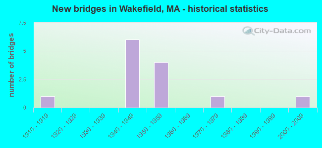
- New bridges - historical statistics
- 11910-1919
- 61940-1949
- 41950-1959
- 11970-1979
- 12000-2009
FCC Registered Broadcast Land Mobile Towers: 9 (See the full list of FCC Registered Broadcast Land Mobile Towers in Wakefield, MA)
FCC Registered Microwave Towers: 7 (See the full list of FCC Registered Microwave Towers in this town)
FCC Registered Paging Towers: 3 (See the full list of FCC Registered Paging Towers)
FCC Registered Amateur Radio Licenses: 117 (See the full list of FCC Registered Amateur Radio Licenses in Wakefield)
FAA Registered Aircraft Manufacturers and Dealers: 1 (See the full list of FAA Registered Manufacturers and Dealers in Wakefield)
FAA Registered Aircraft: 9 (See the full list of FAA Registered Aircraft)
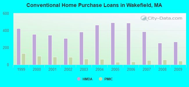
| Home Mortgage Disclosure Act Aggregated Statistics For Year 2009 (Based on 4 full tracts) | ||||||||||||
| A) FHA, FSA/RHS & VA Home Purchase Loans | B) Conventional Home Purchase Loans | C) Refinancings | D) Home Improvement Loans | E) Loans on Dwellings For 5+ Families | F) Non-occupant Loans on < 5 Family Dwellings (A B C & D) | |||||||
|---|---|---|---|---|---|---|---|---|---|---|---|---|
| Number | Average Value | Number | Average Value | Number | Average Value | Number | Average Value | Number | Average Value | Number | Average Value | |
| LOANS ORIGINATED | 53 | $334,925 | 269 | $294,390 | 1,058 | $273,613 | 47 | $150,915 | 1 | $180,000 | 35 | $273,543 |
| APPLICATIONS APPROVED, NOT ACCEPTED | 4 | $374,750 | 15 | $342,533 | 53 | $275,283 | 6 | $53,500 | 0 | $0 | 5 | $291,800 |
| APPLICATIONS DENIED | 6 | $317,167 | 18 | $245,667 | 192 | $299,526 | 6 | $200,667 | 0 | $0 | 10 | $207,400 |
| APPLICATIONS WITHDRAWN | 7 | $279,857 | 20 | $301,600 | 139 | $286,806 | 4 | $107,750 | 0 | $0 | 4 | $201,000 |
| FILES CLOSED FOR INCOMPLETENESS | 0 | $0 | 10 | $344,800 | 47 | $257,021 | 1 | $100,000 | 0 | $0 | 1 | $236,000 |
Detailed HMDA statistics for the following Tracts: 3351.00 , 3352.00, 3353.00, 3354.00
| Private Mortgage Insurance Companies Aggregated Statistics For Year 2009 (Based on 4 full tracts) | ||||
| A) Conventional Home Purchase Loans | B) Refinancings | |||
|---|---|---|---|---|
| Number | Average Value | Number | Average Value | |
| LOANS ORIGINATED | 44 | $331,750 | 52 | $324,692 |
| APPLICATIONS APPROVED, NOT ACCEPTED | 10 | $334,900 | 13 | $340,308 |
| APPLICATIONS DENIED | 8 | $408,375 | 3 | $309,333 |
| APPLICATIONS WITHDRAWN | 5 | $380,200 | 2 | $366,500 |
| FILES CLOSED FOR INCOMPLETENESS | 0 | $0 | 1 | $255,000 |
Detailed PMIC statistics for the following Tracts: 3351.00 , 3352.00, 3353.00, 3354.00
2002 - 2018 National Fire Incident Reporting System (NFIRS) incidents
- Fire incident types reported to NFIRS in Wakefield, MA
- 80378.3%Structure Fires
- 16616.2%Mobile Property/Vehicle Fires
- 373.6%Outside Fires
- 201.9%Other
 Based on the data from the years 2002 - 2018 the average number of fires per year is 60. The highest number of reported fire incidents - 88 took place in 2004, and the least - 38 in 2012. The data has a declining trend.
 When looking into fire subcategories, the most incidents belonged to: Structure Fires (78.3%), and Mobile Property/Vehicle Fires (16.2%).
Fire-safe hotels and motels in Wakefield, Massachusetts:
- Four Points by Sheraton, 1 Audubon Rd, Wakefield, Massachusetts 01880 , Phone: (781) 856-5666, Fax: (781) 246-4636
- Clarion Inn Wakefield, 595 North Ave, Wakefield, Massachusetts 01880 , Phone: (781) 245-6100, Fax: (781) 245-2904
- 50.7%Utility gas
- 41.5%Fuel oil, kerosene, etc.
- 4.6%Electricity
- 2.7%Bottled, tank, or LP gas
- 0.3%Other fuel
- 0.2%No fuel used
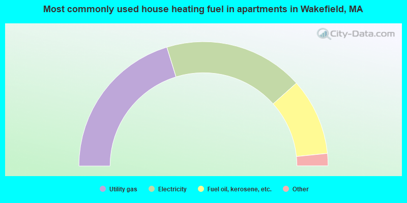
- 40.5%Utility gas
- 36.3%Electricity
- 20.0%Fuel oil, kerosene, etc.
- 2.1%No fuel used
- 1.1%Bottled, tank, or LP gas
Wakefield compared to Massachusetts state average:
- Unemployed percentage significantly below state average.
- Black race population percentage significantly below state average.
- Hispanic race population percentage significantly below state average.
- Foreign-born population percentage below state average.
- Length of stay since moving in significantly above state average.
- Percentage of population with a bachelor's degree or higher above state average.
Wakefield on our top lists:
- #99 on the list of "Top 101 cities with the most residents born in Armenia (population 500+)"
- #90 (01880) on the list of "Top 101 zip codes with the largest percentage of Irish first ancestries (pop 5,000+)"
- #4 on the list of "Top 101 counties with the most Orthodox adherents"
- #7 on the list of "Top 101 counties with the most Catholic adherents"
- #7 on the list of "Top 101 counties with the most Mainline Protestant congregations"
- #7 on the list of "Top 101 counties with the most Orthodox congregations"
- #8 on the list of "Top 101 counties with the lowest percentage of residents that keep firearms around their homes"

|
|
Total of 692 patent applications in 2008-2024.