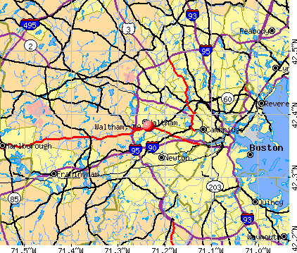
Waltham, Massachusetts
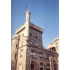
Waltham: Usen Castle @ Brandeis University, Waltham MA

Waltham: dinasaur rock, Prospect Hill, Waltham
Waltham: Charles River along Forest Grove Reservation
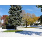
Waltham: Waltham Common with rare October snow

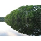
Waltham: Charles River waterfront
- add
your
Submit your own pictures of this city and show them to the world
- OSM Map
- General Map
- Google Map
- MSN Map
Population change since 2000: +8.2%
 |
| Males: 31,725 | |
| Females: 32,340 |
| Median resident age: | 35.1 years |
| Massachusetts median age: | 40.3 years |
Zip codes: 02451, 02452, 02453.
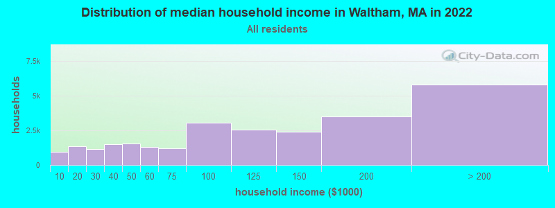
Waltham Zip Code Map| Waltham: | $111,101 |
| MA: | $94,488 |
Estimated per capita income in 2022: $57,227 (it was $26,364 in 2000)
Waltham city income, earnings, and wages data
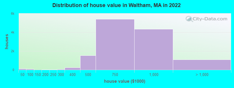
Estimated median house or condo value in 2022: $716,878 (it was $246,400 in 2000)
| Waltham: | $716,878 |
| MA: | $534,700 |
Mean prices in 2022: all housing units: $575,507; detached houses: $595,871; townhouses or other attached units: $651,448; in 2-unit structures: $524,998; in 3-to-4-unit structures: $511,714; in 5-or-more-unit structures: $388,547
Median gross rent in 2022: $2,133.
(6.2% for White Non-Hispanic residents, 13.1% for Black residents, 10.8% for Hispanic or Latino residents, 1.5% for American Indian residents, 12.7% for other race residents, 10.9% for two or more races residents)
Detailed information about poverty and poor residents in Waltham, MA


Compare current foreclosures near Waltham, MA:
| Photo | Address | Area | Beds / Baths | Price | Details |
|---|---|---|---|---|---|

|
#1
College Farm Rd
Waltham, MA 02451
|
879 sq. feet
|
1 baths 2 beds |
show details | |

|
#2
Castle St
Waltham, MA 02451
|
1,292 sq. feet
|
1 baths 2 beds |
show details | |

|
#3
Dorchester St
Waltham, MA 02453
|
2,838 sq. feet
|
2 baths 5 beds |
show details | |

|
#4
Orange St
Waltham, MA 02453
|
2,817 sq. feet
|
4 baths 4 beds |
show details | |

|
#5
Centre St
Waltham, MA 02453
|
2,168 sq. feet
|
1 baths 4 beds |
show details | |

|
#6
Columbus Ave
Waltham, MA 02451
|
3,586 sq. feet
|
1 baths 5 beds |
show details | |

|
#7
Weir Rd
Waltham, MA 02451
|
1,343 sq. feet
|
1 baths 4 beds |
show details | |

|
#8
Crescent St
Waltham, MA 02453
|
4,336 sq. feet
|
2 baths 6 beds |
show details | |

|
#9
Graymore Rd
Waltham, MA 02451
|
2,447 sq. feet
|
3 baths 5 beds |
show details | |

|
#10
College Farm Rd
Waltham, MA 02451
|
1,800 sq. feet
|
1 baths 2 beds |
show details |
| Photo | Address | Area | Beds / Baths | Price | Details |
|---|---|---|---|---|---|

|
#11
Chester Brook Rd
Waltham, MA 02452
|
1,615 sq. feet
|
1 baths 3 beds |
show details | |

|
#12
Hillcrest St
Waltham, MA 02451
|
924 sq. feet
|
1 baths 3 beds |
show details | |

|
#13
Silver Hill Ln
Waltham, MA 02451
|
1,883 sq. feet
|
3 baths 3 beds |
show details | |

|
#14
Mckenn St
Waltham, MA 02453
|
1,968 sq. feet
|
2 baths 6 beds |
show details | |

|
#15
Main St
Waltham, MA 02453
|
3,369 sq. feet
|
2 baths 3 beds |
show details | |

|
#16
Mountain Rd
Waltham, MA 02451
|
1,370 sq. feet
|
1 baths 3 beds |
show details | |

|
#17
Indian Rd
Waltham, MA 02451
|
2,035 sq. feet
|
1 baths 3 beds |
show details | |

|
#18
Kingston Rd
Waltham, MA 02451
|
1,933 sq. feet
|
1 baths 4 beds |
show details | |

|
#19
West St
Waltham, MA 02451
|
5,500 sq. feet
|
1 baths - beds |
show details | |

|
#20
Church St
Waltham, MA 02452
|
1,532 sq. feet
|
1 baths - beds |
show details |
| Photo | Address | Area | Beds / Baths | Price | Details |
|---|---|---|---|---|---|

|
#21
Albemarle Rd
Waltham, MA 02452
|
1,632 sq. feet
|
2 baths - beds |
show details | |

|
#22
Trapelo Rd # 12
Waltham, MA 02452
|
- sq. feet
|
- baths - beds |
show details | |

|
#23
Fiske St
Waltham, MA 02451
|
- sq. feet
|
- baths - beds |
show details | |

|
#24
Crescent St Apt B3
Waltham, MA 02453
|
- sq. feet
|
- baths - beds |
show details | |

|
#25
School Ave Apt C
Waltham, MA 02453
|
- sq. feet
|
- baths - beds |
show details | |

|
#26
Pond St Apt 31
Waltham, MA 02451
|
- sq. feet
|
- baths - beds |
show details | |

|
#27
Moreland St Apt 1
Boston, MA 02119
|
804 sq. feet
|
1 baths 2 beds |
$264,900
|
show details |

|
#28
Stillman St
Framingham, MA 01702
|
1,122 sq. feet
|
1 baths 2 beds |
$440,000
|
show details |

|
#29
Maple St
Tewksbury, MA 01876
|
1,748 sq. feet
|
1 baths 4 beds |
$379,900
|
show details |

|
#30
Commonwealth Ave Apt B
Boston, MA 02116
|
- sq. feet
|
1 baths 2 beds |
$758,900
|
show details |
| Photo | Address | Area | Beds / Baths | Price | Details |
|---|---|---|---|---|---|

|
#31
Church St
Boston, MA 02122
|
3,663 sq. feet
|
3 baths 6 beds |
show details | |

|
#32
Thompson St
Hyde Park, MA 02136
|
1,584 sq. feet
|
1 baths 4 beds |
show details | |

|
#33
Gordon St
Allston, MA 02134
|
3,246 sq. feet
|
2 baths 5 beds |
show details | |

|
#34
Emily Rd
Tewksbury, MA 01876
|
1,600 sq. feet
|
1 baths 3 beds |
show details | |

|
#35
Iroquois St
Boston, MA 02120
|
2,524 sq. feet
|
1 baths 4 beds |
show details | |

|
#36
Dicenzo Blvd # 260
Marlborough, MA 01752
|
1,359 sq. feet
|
2 baths 3 beds |
show details | |

|
#37
Violetwood Cir # No
Marlborough, MA 01752
|
1,784 sq. feet
|
2 baths 3 beds |
show details | |

|
#38
Violetwood Cir
Marlborough, MA 01752
|
1,784 sq. feet
|
2 baths 3 beds |
show details | |

|
#39
Ballou St
Quincy, MA 02169
|
1,758 sq. feet
|
1 baths 3 beds |
show details | |

|
#40
Ruthven St
Quincy, MA 02171
|
988 sq. feet
|
2 baths 4 beds |
show details |
| Photo | Address | Area | Beds / Baths | Price | Details |
|---|---|---|---|---|---|

|
#41
Brahms St
Roslindale, MA 02131
|
1,604 sq. feet
|
1 baths 4 beds |
show details | |

|
#42
Harding Ave
Everett, MA 02149
|
2,051 sq. feet
|
2 baths 4 beds |
show details | |

|
#43
Old Bolton Rd
Hudson, MA 01749
|
1,244 sq. feet
|
1 baths 3 beds |
show details | |

|
#44
Bloomfield St
Boston, MA 02124
|
2,667 sq. feet
|
2 baths 6 beds |
show details | |

|
#45
Marks Way
Maynard, MA 01754
|
2,596 sq. feet
|
2 baths 4 beds |
show details | |

|
#46
Magnolia St
Boston, MA 02125
|
3,654 sq. feet
|
3 baths 6 beds |
show details | |

|
#47
Forest Park Rd
Woburn, MA 01801
|
1,132 sq. feet
|
1 baths 3 beds |
show details | |

|
#48
Water Wheel Ln
Saugus, MA 01906
|
5,649 sq. feet
|
3 baths 4 beds |
show details | |

|
#49
Marden Ave # 6
Boston, MA 02124
|
1,639 sq. feet
|
1 baths 3 beds |
show details | |

|
Check over 1 million property listings on Foreclosure.com!
|
browse all offers | |||


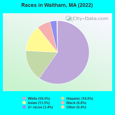
- 38,33659.5%White alone
- 10,32116.0%Hispanic
- 8,71513.5%Asian alone
- 4,4046.8%Black alone
- 2,1793.4%Two or more races
- 2550.4%Other race alone
- 330.05%American Indian alone
- 260.04%Native Hawaiian and Other
Pacific Islander alone
Races in Waltham detailed stats: ancestries, foreign born residents, place of birth
According to our research of Massachusetts and other state lists, there were 17 registered sex offenders living in Waltham, Massachusetts as of April 19, 2024.
The ratio of all residents to sex offenders in Waltham is 3,740 to 1.
The ratio of registered sex offenders to all residents in this city is lower than the state average.
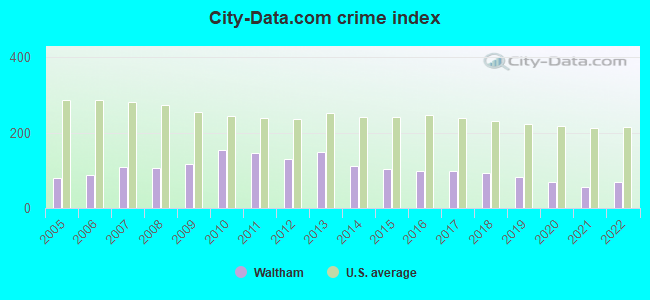
The City-Data.com crime index weighs serious crimes and violent crimes more heavily. Higher means more crime, U.S. average is 246.1. It adjusts for the number of visitors and daily workers commuting into cities.
- means the value is smaller than the state average.- means the value is about the same as the state average.
Crime rate in Waltham detailed stats: murders, rapes, robberies, assaults, burglaries, thefts, arson
Full-time law enforcement employees in 2021, including police officers: 154 (148 officers - 133 male; 15 female).
| Officers per 1,000 residents here: | 2.36 |
| Massachusetts average: | 2.53 |
 Recent articles from our blog. Our writers, many of them Ph.D. graduates or candidates, create easy-to-read articles on a wide variety of topics.


Latest news from Waltham, MA collected exclusively by city-data.com from local newspapers, TV, and radio stations
Ancestries: Irish (10.1%), Italian (9.9%), English (3.6%), Armenian (3.5%), American (2.8%), French Canadian (2.5%).
Current Local Time: EST time zone
Elevation: 50 feet
Land area: 12.7 square miles.
Population density: 5,044 people per square mile (average).
17,111 residents are foreign born (11.4% Asia, 8.3% Latin America, 2.8% Europe).
| This city: | 26.5% |
| Massachusetts: | 17.6% |
Median real estate property taxes paid for housing units with mortgages in 2022: $4,771 (0.6%)
Median real estate property taxes paid for housing units with no mortgage in 2022: $4,591 (0.7%)
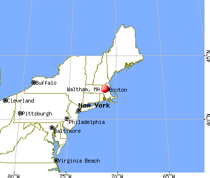
Nearest city with pop. 200,000+: Boston, MA  (8.5 miles , pop. 589,141).
Nearest city with pop. 1,000,000+: Bronx, NY (172.8 miles , pop. 1,332,650).
Nearest cities:
), ), Latitude: 42.38 N, Longitude: 71.24 W
Daytime population change due to commuting: +17,225 (+26.7%)
Workers who live and work in this city: 17,955 (47.5%)
Area codes: 781, 617, 339
Property values in Waltham, MA
Waltham tourist attractions:
Waltham, Massachusetts accommodation & food services, waste management - Economy and Business Data
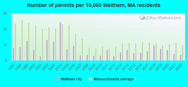
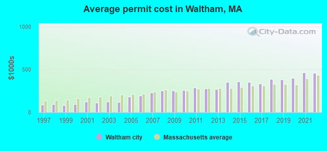
Single-family new house construction building permits:
- 2022: 22 buildings, average cost: $458,500
- 2021: 26 buildings, average cost: $464,600
- 2020: 41 buildings, average cost: $403,300
- 2019: 45 buildings, average cost: $382,600
- 2018: 57 buildings, average cost: $391,000
- 2017: 36 buildings, average cost: $336,900
- 2016: 30 buildings, average cost: $356,000
- 2015: 28 buildings, average cost: $357,800
- 2014: 41 buildings, average cost: $351,200
- 2013: 32 buildings, average cost: $274,200
- 2012: 17 buildings, average cost: $276,400
- 2011: 41 buildings, average cost: $290,600
- 2010: 20 buildings, average cost: $257,300
- 2009: 19 buildings, average cost: $256,100
- 2008: 22 buildings, average cost: $250,800
- 2007: 21 buildings, average cost: $232,100
- 2006: 57 buildings, average cost: $192,400
- 2005: 43 buildings, average cost: $184,100
- 2004: 145 buildings, average cost: $119,100
- 2003: 72 buildings, average cost: $122,000
- 2002: 78 buildings, average cost: $111,900
- 2001: 17 buildings, average cost: $122,600
- 2000: 42 buildings, average cost: $95,900
- 1999: 75 buildings, average cost: $81,200
- 1998: 53 buildings, average cost: $96,100
- 1997: 48 buildings, average cost: $86,800
| Here: | 3.0% |
| Massachusetts: | 3.5% |

Population change in the 1990s: +1,355 (+2.3%).
- Professional, scientific, technical services (12.3%)
- Educational services (11.9%)
- Health care (9.2%)
- Finance & insurance (7.3%)
- Accommodation & food services (5.2%)
- Computer & electronic products (4.6%)
- Construction (4.4%)
- Professional, scientific, technical services (12.8%)
- Educational services (8.2%)
- Construction (7.6%)
- Finance & insurance (6.2%)
- Accommodation & food services (5.5%)
- Computer & electronic products (5.2%)
- Health care (4.7%)
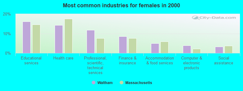
- Educational services (16.1%)
- Health care (14.3%)
- Professional, scientific, technical services (11.8%)
- Finance & insurance (8.5%)
- Accommodation & food services (4.9%)
- Computer & electronic products (3.8%)
- Social assistance (3.3%)
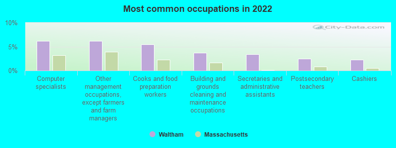
- Computer specialists (6.2%)
- Other management occupations, except farmers and farm managers (6.2%)
- Cooks and food preparation workers (5.4%)
- Building and grounds cleaning and maintenance occupations (3.7%)
- Secretaries and administrative assistants (3.4%)
- Postsecondary teachers (2.5%)
- Cashiers (2.3%)
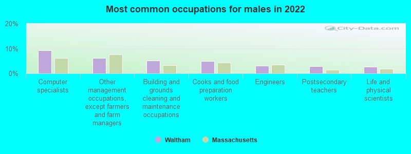
- Computer specialists (9.2%)
- Other management occupations, except farmers and farm managers (6.1%)
- Building and grounds cleaning and maintenance occupations (5.1%)
- Cooks and food preparation workers (5.0%)
- Engineers (3.2%)
- Postsecondary teachers (2.9%)
- Life and physical scientists (2.7%)

- Other management occupations, except farmers and farm managers (6.2%)
- Cooks and food preparation workers (5.8%)
- Secretaries and administrative assistants (5.8%)
- Other office and administrative support workers, including supervisors (3.4%)
- Cashiers (3.2%)
- Computer specialists (3.2%)
- Registered nurses (3.1%)
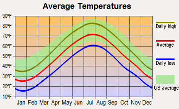
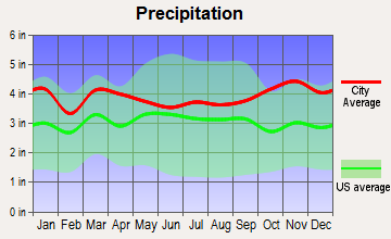
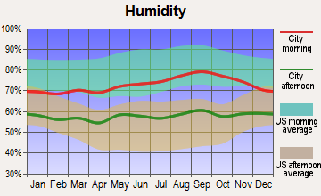
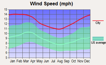
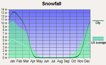
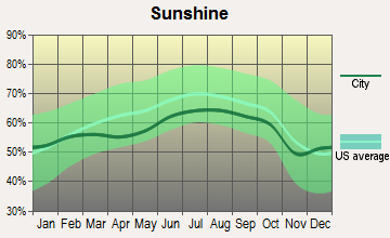
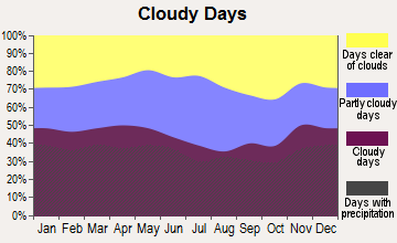
Average climate in Waltham, Massachusetts
Based on data reported by over 4,000 weather stations
|
|
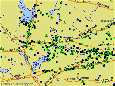

(lower is better)
Air Quality Index (AQI) level in 2022 was 74.3. This is about average.
| City: | 74.3 |
| U.S.: | 72.6 |
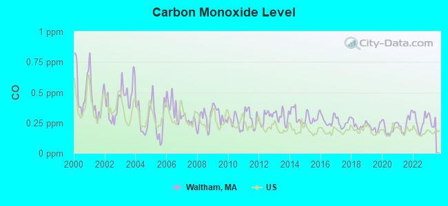
Carbon Monoxide (CO) [ppm] level in 2022 was 0.261. This is about average. Closest monitor was 0.5 miles away from the city center.
| City: | 0.261 |
| U.S.: | 0.251 |
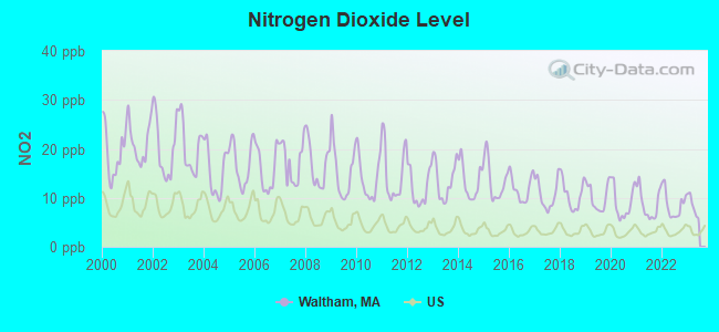
Nitrogen Dioxide (NO2) [ppb] level in 2022 was 8.63. This is significantly worse than average. Closest monitor was 0.5 miles away from the city center.
| City: | 8.63 |
| U.S.: | 5.11 |
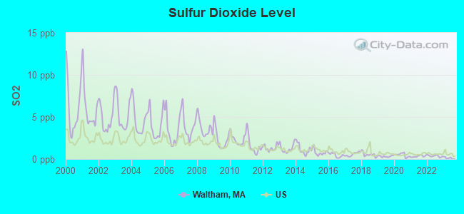
Sulfur Dioxide (SO2) [ppb] level in 2022 was 0.358. This is significantly better than average. Closest monitor was 0.5 miles away from the city center.
| City: | 0.358 |
| U.S.: | 1.515 |
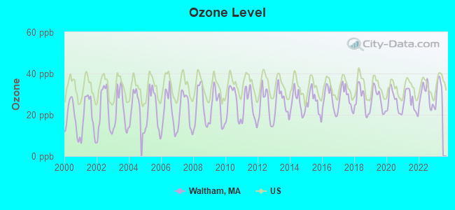
Ozone [ppb] level in 2022 was 29.2. This is about average. Closest monitor was 0.5 miles away from the city center.
| City: | 29.2 |
| U.S.: | 33.3 |
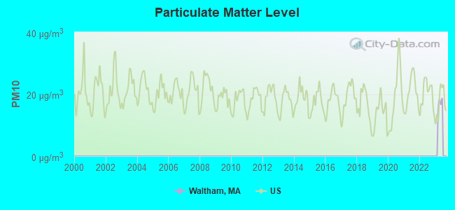
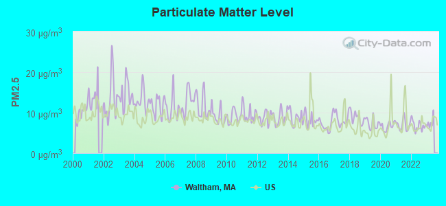
Particulate Matter (PM2.5) [µg/m3] level in 2022 was 6.81. This is about average. Closest monitor was 7.4 miles away from the city center.
| City: | 6.81 |
| U.S.: | 8.11 |
Tornado activity:
Waltham-area historical tornado activity is near Massachusetts state average. It is 38% smaller than the overall U.S. average.
On 6/9/1953, a category F4 (max. wind speeds 207-260 mph) tornado 15.6 miles away from the Waltham city center killed 90 people and injured 1228 people and caused between $50,000,000 and $500,000,000 in damages.
On 9/29/1974, a category F3 (max. wind speeds 158-206 mph) tornado 15.2 miles away from the city center injured one person and caused between $50,000 and $500,000 in damages.
Earthquake activity:
Waltham-area historical earthquake activity is significantly above Massachusetts state average. It is 73% smaller than the overall U.S. average.On 10/7/1983 at 10:18:46, a magnitude 5.3 (5.1 MB, 5.3 LG, 5.1 ML, Class: Moderate, Intensity: VI - VII) earthquake occurred 190.8 miles away from Waltham center
On 4/20/2002 at 10:50:47, a magnitude 5.3 (5.3 ML, Depth: 3.0 mi) earthquake occurred 192.4 miles away from the city center
On 1/19/1982 at 00:14:42, a magnitude 4.7 (4.5 MB, 4.7 MD, 4.5 LG, Class: Light, Intensity: IV - V) earthquake occurred 79.6 miles away from Waltham center
On 4/20/2002 at 10:50:47, a magnitude 5.2 (5.2 MB, 4.2 MS, 5.2 MW, 5.0 MW) earthquake occurred 191.8 miles away from the city center
On 10/16/2012 at 23:12:25, a magnitude 4.7 (4.7 ML, Depth: 10.0 mi) earthquake occurred 89.1 miles away from the city center
On 8/22/1992 at 12:20:32, a magnitude 4.8 (4.8 MB, 3.8 MS, 4.7 LG, Depth: 6.2 mi) earthquake occurred 231.5 miles away from Waltham center
Magnitude types: regional Lg-wave magnitude (LG), body-wave magnitude (MB), duration magnitude (MD), local magnitude (ML), surface-wave magnitude (MS), moment magnitude (MW)
Natural disasters:
The number of natural disasters in Middlesex County (31) is a lot greater than the US average (15).Major Disasters (Presidential) Declared: 17
Emergencies Declared: 14
Causes of natural disasters: Floods: 12, Storms: 9, Hurricanes: 6, Snowstorms: 6, Winter Storms: 5, Blizzards: 2, Snows: 2, Explosion: 1, Heavy Rain: 1, Snowfall: 1, Water Main Break: 1, Wind: 1 (Note: some incidents may be assigned to more than one category).
Main business address for: CMGI INC (SERVICES-DIRECT MAIL ADVERTISING SERVICES), LIONBRIDGE TECHNOLOGIES INC /DE/ (SERVICES-BUSINESS SERVICES, NEC), NETEGRITY INC (SERVICES-PREPACKAGED SOFTWARE), POLAROID HOLDING CO (PHOTOGRAPHIC EQUIPMENT & SUPPLIES), REPLIGEN CORP (BIOLOGICAL PRODUCTS (NO DIAGNOSTIC SUBSTANCES)), PAREXEL INTERNATIONAL CORP (SERVICES-COMMERCIAL PHYSICAL & BIOLOGICAL RESEARCH), PHASE FORWARD INC (SERVICES-BUSINESS SERVICES, NEC), NeuroMetrix, Inc. (SURGICAL & MEDICAL INSTRUMENTS & APPARATUS) and 6 other public companies.
Hospitals in Waltham:
- EVERCARE HOSPICE AND PALLIATIVE CARE (950 WINTER STREET, SUITE 3800)
- OLYMPUS SPECIALTY HOSPITAL (775 TRAPELO ROAD)
- PARTNERS HOSPICE, INC (281 WINTER STREET, SUITE 200)
- WALDEN BEHAVIORAL CARE, LLC (9 HOPE AVENUE)
- WALTHAM HOSPITAL (HOPE AVENUE)
Nursing Homes in Waltham:
- HOPKINS NURSING HOME - OLD (508 LEXINGTON ST)
- JOSEPH G RILEY MD TRANSITIONAL (6 HOPE AVENUE)
- LARCHWOOD LODGE NURSING HOME INC (221 WORCESTER LANE)
- MARISTHILL N H (66 NEWTON ST)
- MARISTHILL NURSING AND REHABILITATION CENTER (66 NEWTON STREET)
- MEADOW GREEN NURSING AND REHABILITATION CENTER (45 WOBURN STREET)
- PIETY CORNER NURSING HOME, INC (325 BACON ST)
- PROSPECT HILL NURSING HOME (31 WOODLAND RD)
- RESERVOIR CENTER (1841 TRAPELO ROAD)
- RESERVOIR NURSING HOME (1841 TRAPELO RD)
- WALTHAM NURSING HOME (91 SUMMER ST)
Dialysis Facilities in Waltham:
Home Health Centers in Waltham:
Heliports located in Waltham:
- Federal Center Heliport (5MA0)
- Prospect Hill Heliport (MA92)
- Waltham Weston Hospital & Medical Center Heliport (MA76)
Amtrak stations near Waltham:
- 9 miles: BACK BAY (BOSTON, 145 DARTMOUTH ST.) . Services: ticket office, partially wheelchair accessible, enclosed waiting area, public restrooms, public payphones, vending machines, ATM, paid short-term parking, paid long-term parking, call for car rental service, taxi stand, public transit connection.
- 9 miles: BOSTON, NORTH STATION (BOSTON, 126 CAUSEWAY ST.) . Services: ticket office, enclosed waiting area.
- 10 miles: BOSTON (SO. STA) (BOSTON, ATLANTIC AVE. & SUMMER ST.) . Services: ticket office, fully wheelchair accessible, enclosed waiting area, public restrooms, public payphones, full-service food facilities and snack bar, ATM, paid short-term parking, paid long-term parking, call for car rental service, taxi stand, intercity bus service, public transit connection.
Colleges/Universities in Waltham:
Other colleges/universities with over 2000 students near Waltham:
- Boston College (about 5 miles; Chestnut Hill, MA; Full-time enrollment: 12,070)
- Massachusetts Bay Community College (about 5 miles; Wellesley Hills, MA; FT enrollment: 3,636)
- Harvard University (about 6 miles; Cambridge, MA; FT enrollment: 20,857)
- Babson College (about 7 miles; Wellesley, MA; FT enrollment: 3,230)
- Tufts University (about 7 miles; Medford, MA; FT enrollment: 9,041)
- Lesley University (about 7 miles; Cambridge, MA; FT enrollment: 4,317)
- Cambridge College (about 7 miles; Cambridge, MA; FT enrollment: 2,782)
Public high school in Waltham:
- WALTHAM SR HIGH (Students: 1,535, Location: 617 LEXINGTON STREET, Grades: 9-12)
Private high schools in Waltham:
Public elementary/middle schools in Waltham:
- JOHN W. MCDEVITT MIDDLE SCHOOL (Students: 546, Location: 75 CHURCH STREET, Grades: 6-8)
- JOHN F KENNEDY MIDDLE (Students: 536, Location: 655 LEXINGTON ST, Grades: 6-8)
- WILLIAM F. STANLEY ELEMENTARY SCHOOL (Students: 451, Location: 250 SOUTH STREET, Grades: PK-5)
- NORTHEAST ELEMENTARY SCHOOL (Students: 433, Location: 70 PUTNEY LANE, Grades: PK-5)
- DOUGLAS MACARTHUR ELEMENTARY SCHOOL (Students: 371, Location: 494 LINCOLN STREET, Grades: KG-5)
- THOMAS R PLYMPTON ELEMENTARY SCHOOL (Students: 310, Location: 20 FARNSWORTH STREET, Grades: KG-5)
- JAMES FITZGERALD ELEMENTARY SCHOOL (Students: 282, Location: 140 BEAL ROAD, Grades: KG-5)
- HENRY WHITTEMORE ELEMENTARY SCHOOL (Students: 248, Location: 30 PARMENTER ROAD, Grades: KG-5)
Private elementary/middle schools in Waltham:
Library in Waltham:
- WALTHAM PUBLIC LIBRARY (Operating income: $2,132,793; Location: 735 MAIN ST.; 158,205 books; 3,462 e-books; 24,095 audio materials; 18,510 video materials; 16 local licensed databases; 31 state licensed databases; 3 other licensed databases; 400 print serial subscriptions; 1 electronic serial subscriptions)
Points of interest:
Notable locations in Waltham: Brandeis-Roberts Station (A), Waltham Station (B), Lowell Playground (C), Ceder Hill Camp (D), Camp Ted (E), Camp Cabot (F), Waltham Plaza (G), Prospect Hill Ski Area (H), Waltham Federal Center (I), Waltham Industrial Center (J), Waltham Research and Development Park (K), Waltham Fire Department Station 4 (L), Waltham Fire Department Station 7 (M), Waltham Fire Department Station 3 (N), Waltham Fire Department Station 8 (O), Waltham Fire Department Station 1 (P), Waltham Fire Department Station 2 Headquarters (Q), William F Stanley Elementary School Library (R), Henry Whittemore School Library Media Center (S), Goldfarb Library (T). Display/hide their locations on the map
Shopping Centers: Bellerica Mall (1), Wal-Len Shopping Center (2), Wal-Lex Shopping Center (3), Waltham Plaza Shopping Center (4). Display/hide their locations on the map
Main business address in Waltham include: CMGI INC (A), NETEGRITY INC (B), POLAROID HOLDING CO (C), REPLIGEN CORP (D), PAREXEL INTERNATIONAL CORP (E), PHASE FORWARD INC (F), NeuroMetrix, Inc. (G). Display/hide their locations on the map
Cemeteries: Grove Hill Cemetery (1), Mount Feake Cemetery (2). Display/hide their locations on the map
Lakes and reservoirs: McCusker Pond (A), Tottens Pond (B), Cambridge Reservoir (C), Hardys Pond (D), Lyman Pond (E). Display/hide their locations on the map
Streams, rivers, and creeks: Webb Brook (A), Beaver Brook (B), Stony Brook (C), Chester Brook (D), Clematis Brook (E). Display/hide their locations on the map
Parks in Waltham include: Auburndale Playground (1), Waltham Common (2), Bradford Drake Playground (3), Prospect Hill Park (4), Beaver Brook Reservation (5). Display/hide their locations on the map
Tourist attractions: Charles River Museum of Industry (154 Moody Street), Gore Place Society (Museums; 52 Gore Street), Brandeis University - Rose Art Museum (333 Wyman Street), Gore Place (Museums; 52 Gore St), Lyman Estate (Historical Places & Services; 185 Lyman), Reproductive Science Center of Boston (Nature Centers; Deaconess-Waltham Hospital - Hope Avenue).
Hotels: JE Furnished Apartments (345 Lincoln St), Homestead Village Guest Studios (52 4th Avenue), Holiday Inn Express (385 Winter Street), Homestead Boston Waltham (52 4th Ave), Four Points By Sheraton Waltham (420 Totten Pond Rd), Michaels Italian Grille (477 Totten Pond Road), Finnigans at Best Western (380 Winter Street), Grill at Hobbs Brook (550 Winter Street), Park Lodge Hotel (455 Totten Pond Road).
Courts: A1 Computer Repair Sales Networking & Upgrade Services (174 Lexington Street), Waltham District Court - District Attorney's Office (Middlesex County).
Birthplace of: C. D. Howe - born politician, Nathaniel P. Banks - Union Army general, John Lynch (New Hampshire) - Manufacturing businesspeople, Angelo Mosca - Player of and football, James Chirillo - Jazz guitar, Brian Strait - Ice hockey player, John Peabody Harrington - Anthropologist, Charles J. Precourt - Astronaut, Keith Aucoin - NHL player (Carolina Hurricanes, born: Nov 6, 1978), Kenneth G. Wilson - Physicist.
Drinking water stations with addresses in Waltham and their reported violations in the past:
WALTHAM WATER DEPT. (Population served: 60,630, Purch surface water):Past health violations:Past monitoring violations:
- MCL, Monthly (TCR) - In SEP-2013, Contaminant: Coliform. Follow-up actions: St AO (w/o penalty) issued (OCT-04-2013)
- MCL, Monthly (TCR) - In SEP-2012, Contaminant: Coliform. Follow-up actions: St AO (w/o penalty) issued (SEP-13-2012)
- MCL, Monthly (TCR) - In AUG-2012, Contaminant: Coliform. Follow-up actions: St AO (w/o penalty) issued (AUG-27-2012)
- One routine major monitoring violation
| This city: | 2.3 people |
| Massachusetts: | 2.5 people |
| This city: | 52.7% |
| Whole state: | 63.0% |
| This city: | 7.1% |
| Whole state: | 7.0% |
Likely homosexual households (counted as self-reported same-sex unmarried-partner households)
- Lesbian couples: 0.7% of all households
- Gay men: 0.4% of all households
People in group quarters in Waltham in 2010:
- 5,975 people in college/university student housing
- 287 people in nursing facilities/skilled-nursing facilities
- 134 people in other noninstitutional facilities
- 122 people in residential treatment centers for adults
- 105 people in emergency and transitional shelters (with sleeping facilities) for people experiencing homelessness
- 25 people in workers' group living quarters and job corps centers
- 17 people in group homes intended for adults
- 13 people in group homes for juveniles (non-correctional)
- 8 people in residential schools for people with disabilities
People in group quarters in Waltham in 2000:
- 4,730 people in college dormitories (includes college quarters off campus)
- 459 people in nursing homes
- 261 people in schools, hospitals, or wards for the intellectually disabled
- 206 people in other nonhousehold living situations
- 124 people in homes for the mentally retarded
- 90 people in other noninstitutional group quarters
- 63 people in religious group quarters
- 29 people in hospitals/wards and hospices for chronically ill
- 29 people in other hospitals or wards for chronically ill
- 20 people in homes or halfway houses for drug/alcohol abuse
- 9 people in homes for the mentally ill
Banks with most branches in Waltham (2011 data):
- Bank of America, National Association: Waltham Main Branch, Moody Street Branch, North Waltham Branch. Info updated 2009/11/18: Bank assets: $1,451,969.3 mil, Deposits: $1,077,176.8 mil, headquarters in Charlotte, NC, positive income, 5782 total offices, Holding Company: Bank Of America Corporation
- Sovereign Bank, National Association: North Waltham Branch at 1045 Trapelo Road, branch established on 1973/06/23; Waltham - Moody Street Branch at One Moody Street, branch established on 1853/03/19. Info updated 2012/01/31: Bank assets: $78,146.9 mil, Deposits: $48,042.9 mil, headquarters in Wilmington, DE, positive income, Commercial Lending Specialization, 718 total offices, Holding Company: Banco Santander, S.A.
- Rockland Trust Company: Moody Street Branch at 75 Moody Street, branch established on 1986/05/31; Waltham Branch at 1290 Main Street, branch established on 1996/04/19. Info updated 2009/05/20: Bank assets: $4,974.4 mil, Deposits: $3,903.9 mil, headquarters in Rockland, MA, positive income, Commercial Lending Specialization, 67 total offices, Holding Company: Independent Bank Corp.
- Citibank, National Association: Waltham Branch at 75 Third Avenue, branch established on 2007/10/29. Info updated 2012/01/10: Bank assets: $1,288,658.0 mil, Deposits: $882,541.0 mil, headquarters in Sioux Falls, SD, positive income, International Specialization, 1048 total offices, Holding Company: Citigroup Inc.
- TD Bank, National Association: Waltham Branch at 305 Second Avenue, branch established on 1998/12/29. Info updated 2010/10/04: Bank assets: $188,912.6 mil, Deposits: $153,149.8 mil, headquarters in Wilmington, DE, positive income, 1314 total offices, Holding Company: Toronto-Dominion Bank, The
- Watertown Savings Bank: Waltham Branch at 6 Lexington Street, branch established on 2001/05/14. Info updated 2011/06/29: Bank assets: $1,063.2 mil, Deposits: $947.0 mil, headquarters in Watertown, MA, positive income, Mortgage Lending Specialization, 9 total offices
- East Cambridge Savings Bank: Wal-Lex Shopping Center Branch at 860 Lexington Street, branch established on 2002/05/13. Info updated 2007/04/09: Bank assets: $803.6 mil, Deposits: $690.6 mil, headquarters in Cambridge, MA, positive income, 9 total offices
- The Bank of Canton: Waltham Loan Production Office at 303 Wyman Street, branch established on 2008/12/03. Info updated 2009/02/04: Bank assets: $634.2 mil, Deposits: $543.9 mil, headquarters in Canton, MA, positive income, Commercial Lending Specialization, 9 total offices, Holding Company: Ponkapoag Bancorp, Mhc
- People's United Bank: Waltham Branch at 775-781 Main Street, branch established on 2009/12/14. Info updated 2012/02/16: Bank assets: $27,319.3 mil, Deposits: $20,835.4 mil, headquarters in Bridgeport, CT, positive income, Commercial Lending Specialization, 374 total offices
For population 15 years and over in Waltham:
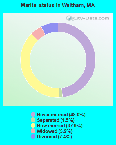
- Never married: 48.0%
- Now married: 37.9%
- Separated: 1.5%
- Widowed: 5.2%
- Divorced: 7.4%
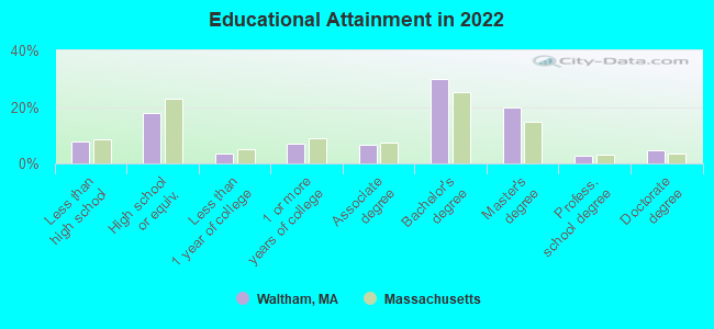
For population 25 years and over in Waltham:
- High school or higher: 92.5%
- Bachelor's degree or higher: 56.6%
- Graduate or professional degree: 27.1%
- Unemployed: 5.4%
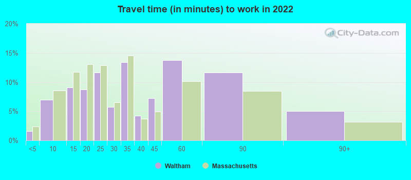
- Mean travel time to work (commute): 17.8 minutes
| Here: | 13.1 |
| Massachusetts average: | 13.0 |


Graphs represent county-level data. Detailed 2008 Election Results
Religion statistics for Waltham, MA (based on Middlesex County data)


| Religion | Adherents | Congregations |
|---|---|---|
| Catholic | 718,209 | 107 |
| Mainline Protestant | 70,053 | 269 |
| Other | 68,480 | 199 |
| Evangelical Protestant | 41,270 | 304 |
| Orthodox | 23,641 | 28 |
| Black Protestant | 2,276 | 8 |
| None | 579,156 | - |
Food Environment Statistics:
| Here: | 1.71 / 10,000 pop. |
| Massachusetts: | 1.98 / 10,000 pop. |
| Middlesex County: | 0.03 / 10,000 pop. |
| Massachusetts: | 0.05 / 10,000 pop. |
| Middlesex County: | 2.14 / 10,000 pop. |
| Massachusetts: | 2.22 / 10,000 pop. |
| Here: | 1.38 / 10,000 pop. |
| Massachusetts: | 1.77 / 10,000 pop. |
| Middlesex County: | 7.84 / 10,000 pop. |
| Massachusetts: | 8.76 / 10,000 pop. |
| This county: | 7.8% |
| Massachusetts: | 8.1% |
| This county: | 21.5% |
| Massachusetts: | 22.5% |
| This county: | 18.0% |
| Massachusetts: | 16.5% |
Health and Nutrition:
| Waltham: | 51.0% |
| Massachusetts: | 50.5% |
| This city: | 49.2% |
| Massachusetts: | 48.0% |
| This city: | 27.9 |
| State: | 28.4 |
| Waltham: | 19.2% |
| State: | 20.7% |
| Waltham: | 10.7% |
| State: | 10.4% |
| Waltham: | 6.9 |
| Massachusetts: | 6.8 |
| This city: | 30.6% |
| Massachusetts: | 33.4% |
| This city: | 58.6% |
| Massachusetts: | 57.1% |
| Waltham: | 80.4% |
| Massachusetts: | 79.2% |
More about Health and Nutrition of Waltham, MA Residents
| Local government employment and payroll (March 2022) | |||||
| Function | Full-time employees | Monthly full-time payroll | Average yearly full-time wage | Part-time employees | Monthly part-time payroll |
|---|---|---|---|---|---|
| Elementary and Secondary - Instruction | 884 | $5,538,081 | $75,178 | 91 | $89,755 |
| Elementary and Secondary - Other Total | 209 | $919,708 | $52,806 | 153 | $147,082 |
| Firefighters | 160 | $1,241,036 | $93,078 | 0 | $0 |
| Police Protection - Officers | 135 | $1,219,066 | $108,361 | 0 | $0 |
| Streets and Highways | 53 | $457,640 | $103,617 | 3 | $8,972 |
| Other and Unallocable | 46 | $301,652 | $78,692 | 6 | $12,579 |
| Police - Other | 34 | $250,232 | $88,317 | 2 | $2,732 |
| Financial Administration | 33 | $282,977 | $102,901 | 6 | $6,492 |
| Local Libraries | 19 | $137,742 | $86,995 | 30 | $49,342 |
| Water Supply | 16 | $119,354 | $89,516 | 1 | $2,989 |
| Parks and Recreation | 16 | $117,964 | $88,473 | 29 | $17,188 |
| Other Government Administration | 12 | $107,920 | $107,920 | 5 | $11,541 |
| Sewerage | 12 | $92,495 | $92,495 | 0 | $0 |
| Judicial and Legal | 8 | $87,159 | $130,739 | 0 | $0 |
| Health | 8 | $69,816 | $104,724 | 7 | $24,424 |
| Welfare | 8 | $58,851 | $88,277 | 2 | $1,727 |
| Fire - Other | 3 | $20,292 | $81,168 | 0 | $0 |
| Housing and Community Development (Local) | 3 | $27,112 | $108,448 | 0 | $0 |
| Totals for Government | 1,659 | $11,049,097 | $79,921 | 335 | $374,823 |
Waltham government finances - Expenditure in 2021 (per resident):
- Current Operations - Elementary and Secondary Education: $128,452,000 ($2005.03)
Local Fire Protection: $18,426,000 ($287.61)
Police Protection: $18,129,000 ($282.98)
General - Other: $15,654,000 ($244.35)
Sewerage: $15,502,000 ($241.97)
Water Utilities: $12,357,000 ($192.88)
Regular Highways: $10,792,000 ($168.45)
Solid Waste Management: $5,780,000 ($90.22)
Protective Inspection and Regulation - Other: $3,468,000 ($54.13)
General Public Buildings: $3,178,000 ($49.61)
Libraries: $2,667,000 ($41.63)
Financial Administration: $2,468,000 ($38.52)
Parks and Recreation: $1,848,000 ($28.85)
Housing and Community Development: $1,753,000 ($27.36)
Central Staff Services: $1,349,000 ($21.06)
Judicial and Legal Services: $1,291,000 ($20.15)
Health - Other: $914,000 ($14.27)
Public Welfare - Other: $324,000 ($5.06)
Parking Facilities: $309,000 ($4.82)
Natural Resources - Other: $45,000 ($0.70)
Miscellaneous Commercial Activities - Other: $7,000 ($0.11)
- General - Interest on Debt: $4,159,000 ($64.92)
- Intergovernmental to Local - Other - Elementary and Secondary Education: $1,393,000 ($21.74)
Other - Central Staff Services: $34,000 ($0.53)
Other - Health - Other: $23,000 ($0.36)
- Intergovernmental to State - Transit Utilities: $1,410,000 ($22.01)
General - Other: $67,000 ($1.05)
- Other Capital Outlay - Elementary and Secondary Education: $48,519,000 ($757.34)
General Public Building: $2,918,000 ($45.55)
Central Staff Services: $2,471,000 ($38.57)
General - Other: $1,787,000 ($27.89)
Sewerage: $1,588,000 ($24.79)
Water Utilities: $634,000 ($9.90)
Police Protection: $589,000 ($9.19)
Regular Highways: $274,000 ($4.28)
Local Fire Protection: $252,000 ($3.93)
Parks and Recreation: $39,000 ($0.61)
Public Welfare - Other: $14,000 ($0.22)
Parking Facilities: $11,000 ($0.17)
Protective Inspection and Regulation - Other: $6,000 ($0.09)
Financial Administration: $4,000 ($0.06)
Libraries: $2,000 ($0.03)
- Total Salaries and Wages: $80,015,000 ($1248.97)
- Water Utilities - Interest on Debt: $148,000 ($2.31)
Waltham government finances - Revenue in 2021 (per resident):
- Charges - Sewerage: $17,514,000 ($273.38)
Elementary and Secondary Education School Lunch: $1,362,000 ($21.26)
Other: $1,068,000 ($16.67)
Parks and Recreation: $447,000 ($6.98)
Parking Facilities: $331,000 ($5.17)
Miscellaneous Commercial Activities: $127,000 ($1.98)
Elementary and Secondary Education School Tuition and Transportation: $118,000 ($1.84)
- Federal Intergovernmental - Other: $15,032,000 ($234.64)
Housing and Community Development: $1,638,000 ($25.57)
- Miscellaneous - General Revenue - Other: $9,772,000 ($152.53)
Interest Earnings: $866,000 ($13.52)
Donations From Private Sources: $524,000 ($8.18)
Fines and Forfeits: $333,000 ($5.20)
Special Assessments: $1,000 ($0.02)
- Revenue - Water Utilities: $13,938,000 ($217.56)
- State Intergovernmental - Education: $37,786,000 ($589.81)
General Local Government Support: $10,638,000 ($166.05)
Sewerage: $2,991,000 ($46.69)
Other: $2,175,000 ($33.95)
Highways: $1,702,000 ($26.57)
Public Welfare: $83,000 ($1.30)
- Tax - Property: $202,966,000 ($3168.13)
Other License: $9,309,000 ($145.31)
Other Selective Sales: $2,411,000 ($37.63)
Waltham government finances - Debt in 2021 (per resident):
- Long Term Debt - Outstanding Unspecified Public Purpose: $248,710,000 ($3882.15)
Issue, Unspecified Public Purpose: $144,947,000 ($2262.50)
Beginning Outstanding - Unspecified Public Purpose: $116,241,000 ($1814.42)
Retired Unspecified Public Purpose: $12,478,000 ($194.77)
Waltham government finances - Cash and Securities in 2021 (per resident):
- Bond Funds - Cash and Securities: $124,082,000 ($1936.81)
- Other Funds - Cash and Securities: $127,463,000 ($1989.59)
6.91% of this county's 2021 resident taxpayers lived in other counties in 2020 ($102,955 average adjusted gross income)
| Here: | 6.91% |
| Massachusetts average: | 6.35% |
0.01% of residents moved from foreign countries ($137 average AGI)
Middlesex County: 0.01% Massachusetts average: 0.01%
Top counties from which taxpayers relocated into this county between 2020 and 2021:
| from Suffolk County, MA | |
| from Essex County, MA | |
| from Norfolk County, MA |
8.22% of this county's 2020 resident taxpayers moved to other counties in 2021 ($123,369 average adjusted gross income)
| Here: | 8.22% |
| Massachusetts average: | 7.18% |
0.01% of residents moved to foreign countries ($124 average AGI)
Middlesex County: 0.01% Massachusetts average: 0.02%
Top counties to which taxpayers relocated from this county between 2020 and 2021:
| to Suffolk County, MA | |
| to Essex County, MA | |
| to Worcester County, MA |
| Businesses in Waltham, MA | ||||
| Name | Count | Name | Count | |
|---|---|---|---|---|
| AT&T | 2 | KFC | 1 | |
| Advance Auto Parts | 1 | Marriott | 1 | |
| AutoZone | 1 | MasterBrand Cabinets | 12 | |
| Best Western | 1 | McDonald's | 2 | |
| Burger King | 2 | Nike | 4 | |
| CVS | 3 | Panera Bread | 1 | |
| Costco | 1 | Payless | 2 | |
| DHL | 1 | Penske | 1 | |
| Decora Cabinetry | 2 | Quiznos | 1 | |
| Domino's Pizza | 1 | RadioShack | 2 | |
| DressBarn | 1 | Rite Aid | 1 | |
| Dressbarn | 1 | Shaw's | 2 | |
| Dunkin Donuts | 7 | Staples | 1 | |
| Extended Stay Deluxe | 1 | Subway | 2 | |
| FedEx | 25 | T-Mobile | 1 | |
| GNC | 1 | T.J.Maxx | 1 | |
| GameStop | 1 | True Value | 1 | |
| H&R Block | 2 | U-Haul | 1 | |
| Hilton | 2 | UPS | 31 | |
| Holiday Inn | 1 | Walgreens | 2 | |
| Home Depot | 1 | Wendy's | 1 | |
| Homestead Studio Suites | 1 | Westin | 1 | |
| Jones New York | 1 | YMCA | 1 | |
Strongest AM radio stations in Waltham:
- WWZN (1510 AM; 50 kW; BOSTON, MA; Owner: ROSE CITY RADIO CORPORATION)
- WRCA (1330 AM; 25 kW; WALTHAM, MA; Owner: WRCA LICENSE, LLC)
- WNTN (1550 AM; 10 kW; NEWTON, MA; Owner: COLT COMMUNICATIONS, LLC)
- WRKO (680 AM; 50 kW; BOSTON, MA; Owner: ENTERCOM BOSTON LICENSE, LLC)
- WEEI (850 AM; 50 kW; BOSTON, MA; Owner: ENTERCOM BOSTON LICENSE, LLC)
- WBPS (1150 AM; 5 kW; BOSTON, MA; Owner: MEGA COMMUNICATIONS OF BOSTON LICENSEE, L.L.C.)
- WKOX (1200 AM; 50 kW; FRAMINGHAM, MA; Owner: CAPSTAR TX LIMITED PARTNERSHIP)
- WUNR (1600 AM; 20 kW; BROOKLINE, MA; Owner: CHAMPION BROADCASTING SYSTEMS, INC.)
- WBIX (1060 AM; 40 kW; NATICK, MA; Owner: LANGER BROADCASTING CORPORATION)
- WAMG (890 AM; 25 kW; DEDHAM, MA; Owner: MEGA COMMUNICATIONS OF DEDHAM LICENSEE, LLC)
- WEZE (590 AM; 5 kW; BOSTON, MA; Owner: NEW ENGLAND CONTINENTAL MEDIA, INC.)
- WBZ (1030 AM; 50 kW; BOSTON, MA; Owner: INFINITY BROADCASTING OPERATIONS, INC.)
- WILD (1090 AM; daytime; 5 kW; BOSTON, MA; Owner: RADIO ONE OF BOSTON LICENSES, LLC)
Strongest FM radio stations in Waltham:
- WBMX (98.5 FM; BOSTON, MA; Owner: INFINITY RADIO OPERATIONS INC.)
- WJMN (94.5 FM; BOSTON, MA; Owner: AMFM RADIO LICENSES, L.L.C.)
- WCRB (102.5 FM; WALTHAM, MA; Owner: CHARLES RIVER BROADCASTING WCRB LICE)
- WTKK (96.9 FM; BOSTON, MA; Owner: GREATER BOSTON RADIO, INC.)
- WROR-FM (105.7 FM; FRAMINGHAM, MA; Owner: GREATER BOSTON RADIO, INC.)
- WGBH (89.7 FM; BOSTON, MA; Owner: WGBH EDUCATIONAL FOUNDATION)
- WBOS (92.9 FM; BROOKLINE, MA; Owner: GREATER BOSTON RADIO, INC.)
- WBUR-FM (90.9 FM; BOSTON, MA; Owner: TRUSTEES OF BOSTON UNIVERSITY)
- WODS (103.3 FM; BOSTON, MA; Owner: INFINITY BROADCASTING OPERATIONS, INC.)
- WBRS (100.1 FM; WALTHAM, MA; Owner: BRANDEIS UNIVERSITY)
- WXKS-FM (107.9 FM; MEDFORD, MA; Owner: AMFM RADIO LICENSES, L.L.C.)
- WMJX (106.7 FM; BOSTON, MA; Owner: GREATER BOSTON RADIO, INC.)
- WBCN (104.1 FM; BOSTON, MA; Owner: HEMISPHERE BROADCASTING CORPORATION)
- WZLX (100.7 FM; BOSTON, MA; Owner: INFINITY BROADCASTING CORPORATION OF BOSTON)
- WERS (88.9 FM; BOSTON, MA; Owner: EMERSON COLLEGE)
- W267AI (101.3 FM; BOSTON, MA; Owner: MCC BROADCASTING COMPANY, INC.)
- WHRB (95.3 FM; CAMBRIDGE, MA; Owner: HARVARD RADIO BROADCASTING CO., INC.)
- WZBC (90.3 FM; NEWTON, MA; Owner: TRUSTEES OF BOSTON COLLEGE)
- WFNX (101.7 FM; LYNN, MA; Owner: MCC BROADCASTING COMPANY, INC.)
- WMBR (88.1 FM; CAMBRIDGE, MA; Owner: TECHNOLOGY BROADCASTING CORPORATION)
TV broadcast stations around Waltham:
- WCVB-TV (Channel 5; BOSTON, MA; Owner: WCVB HEARST-ARGYLE TV, INC.)
- WGBH-TV (Channel 2; BOSTON, MA; Owner: WGBH EDUCATIONAL FOUNDATION)
- WHDH-TV (Channel 7; BOSTON, MA; Owner: WHDH-TV)
- WBZ-TV (Channel 4; BOSTON, MA; Owner: VIACOM INC.)
- WGBX-TV (Channel 44; BOSTON, MA; Owner: WGBH EDUCATIONAL FOUNDATION)
- WMFP (Channel 62; LAWRENCE, MA; Owner: WSAH LICENSE, INC.)
- WSBK-TV (Channel 38; BOSTON, MA; Owner: VIACOM INC.)
- WLVI-TV (Channel 56; CAMBRIDGE, MA; Owner: WLVI, INC.)
- WFXT (Channel 25; BOSTON, MA; Owner: FOX TELEVISION STATIONS INC.)
- W40BO (Channel 40; BOSTON, MA; Owner: PAXSON COMMUNICATIONS LPTV, INC.)
- WBPX (Channel 68; BOSTON, MA; Owner: PAXSON BOSTON-68 LICENSE, INC.)
- WTMU-LP (Channel 32; BOSTON, MA; Owner: ZGS BOSTON, INC.)
- WCEA-LP (Channel 58; BOSTON, MA; Owner: CHANNEL 19 TV CORPORATION)
- WUTF (Channel 66; MARLBOROUGH, MA; Owner: TELEFUTURA BOSTON LLC)
- WUNI (Channel 27; WORCESTER, MA; Owner: ENTRAVISION HOLDINGS, LLC)
- WWDP (Channel 46; NORWELL, MA; Owner: NORWELL TELEVISION, LLC)
- WFXZ-CA (Channel 24; BOSTON, MA; Owner: BOSTON BROADCASTING CORP.)
- WNAC-TV (Channel 64; PROVIDENCE, RI; Owner: WNAC, LLC)
- WLNE-TV (Channel 6; NEW BEDFORD, MA; Owner: FREEDOM BROADCASTING OF SOUTHERN NEW ENGLAND, INC.)
- WPRI-TV (Channel 12; PROVIDENCE, RI; Owner: TVL BROADCASTING OF RHODE ISLAND, LLC)
- WJAR (Channel 10; PROVIDENCE, RI; Owner: OUTLET BROADCASTING, INC.)
- WSBE-TV (Channel 36; PROVIDENCE, RI; Owner: RHODE ISLAND PUBLIC TELECOM. AUTHORITY)
- WNDS (Channel 50; DERRY, NH; Owner: CTV OF DERRY, INC)
Medal of Honor Recipients
Medal of Honor Recipient born in Waltham: George H. Maynard.
- National Bridge Inventory (NBI) Statistics
- 21Number of bridges
- 272ft / 83.3mTotal length
- $104,911,000Total costs
- 750,000Total average daily traffic
- 58,277Total average daily truck traffic
- New bridges - historical statistics
- 4Before 1900
- 11910-1919
- 31930-1939
- 21950-1959
- 61960-1969
- 11980-1989
- 11990-1999
- 12000-2009
- 12010-2019
- 12020-2022
FCC Registered Commercial Land Mobile Towers: 1 (See the full list of FCC Registered Commercial Land Mobile Towers in Waltham, MA)
FCC Registered Private Land Mobile Towers: 9 (See the full list of FCC Registered Private Land Mobile Towers)
FCC Registered Broadcast Land Mobile Towers: 42 (See the full list of FCC Registered Broadcast Land Mobile Towers)
FCC Registered Microwave Towers: 50 (See the full list of FCC Registered Microwave Towers in this town)
FCC Registered Paging Towers: 13 (See the full list of FCC Registered Paging Towers)
FCC Registered Amateur Radio Licenses: 220 (See the full list of FCC Registered Amateur Radio Licenses in Waltham)
FAA Registered Aircraft: 13 (See the full list of FAA Registered Aircraft in Waltham)
| Home Mortgage Disclosure Act Aggregated Statistics For Year 2009 (Based on 13 full tracts) | ||||||||||||
| A) FHA, FSA/RHS & VA Home Purchase Loans | B) Conventional Home Purchase Loans | C) Refinancings | D) Home Improvement Loans | E) Loans on Dwellings For 5+ Families | F) Non-occupant Loans on < 5 Family Dwellings (A B C & D) | |||||||
|---|---|---|---|---|---|---|---|---|---|---|---|---|
| Number | Average Value | Number | Average Value | Number | Average Value | Number | Average Value | Number | Average Value | Number | Average Value | |
| LOANS ORIGINATED | 99 | $333,030 | 461 | $272,785 | 1,597 | $272,932 | 58 | $135,431 | 7 | $895,286 | 85 | $295,529 |
| APPLICATIONS APPROVED, NOT ACCEPTED | 4 | $415,000 | 27 | $288,444 | 117 | $275,906 | 7 | $163,286 | 0 | $0 | 4 | $306,500 |
| APPLICATIONS DENIED | 24 | $284,250 | 65 | $208,631 | 320 | $303,122 | 19 | $70,684 | 1 | $14,000,000 | 22 | $235,818 |
| APPLICATIONS WITHDRAWN | 14 | $310,000 | 51 | $266,431 | 265 | $294,747 | 3 | $264,333 | 2 | $967,500 | 15 | $321,800 |
| FILES CLOSED FOR INCOMPLETENESS | 3 | $443,667 | 6 | $300,167 | 77 | $297,844 | 1 | $365,000 | 0 | $0 | 4 | $224,250 |
Detailed mortgage data for all 13 tracts in Waltham, MA
| Private Mortgage Insurance Companies Aggregated Statistics For Year 2009 (Based on 13 full tracts) | ||||||
| A) Conventional Home Purchase Loans | B) Refinancings | C) Non-occupant Loans on < 5 Family Dwellings (A & B) | ||||
|---|---|---|---|---|---|---|
| Number | Average Value | Number | Average Value | Number | Average Value | |
| LOANS ORIGINATED | 78 | $307,705 | 51 | $337,275 | 0 | $0 |
| APPLICATIONS APPROVED, NOT ACCEPTED | 20 | $328,900 | 23 | $341,043 | 0 | $0 |
| APPLICATIONS DENIED | 17 | $285,706 | 8 | $341,000 | 1 | $220,000 |
| APPLICATIONS WITHDRAWN | 3 | $313,667 | 2 | $283,000 | 0 | $0 |
| FILES CLOSED FOR INCOMPLETENESS | 3 | $291,000 | 1 | $305,000 | 0 | $0 |
2002 - 2018 National Fire Incident Reporting System (NFIRS) incidents
- Fire incident types reported to NFIRS in Waltham, MA
- 1,34941.2%Structure Fires
- 1,01731.0%Outside Fires
- 50515.4%Other
- 40612.4%Mobile Property/Vehicle Fires
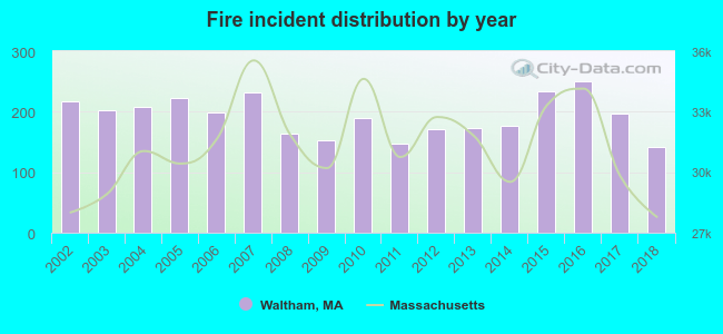 According to the data from the years 2002 - 2018 the average number of fire incidents per year is 193. The highest number of reported fires - 251 took place in 2016, and the least - 142 in 2018. The data has a declining trend.
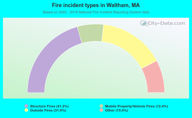 When looking into fire subcategories, the most incidents belonged to: Structure Fires (41.2%), and Outside Fires (31.0%).
Fire-safe hotels and motels in Waltham, Massachusetts:
- Doubletree Guest Suites Boston/Waltham, 550 Winter St, Waltham, Massachusetts 02451 , Phone: (781) 890-6767, Fax: (781) 895-1177
- Extended Stay America - Boston - Waltham - 52 4th Ave, 52 Fourth Ave, Waltham, Massachusetts 02451 , Phone: (781) 890-1333, Fax: (781) 890-1901
- HYATT house Boston/Waltham, 54 Fourth Ave, Waltham, Massachusetts 02451 , Phone: (781) 290-0026, Fax: (781) 290-0037
- Extended Stay America - Boston - Waltham - 32 4th Ave, 32 Fourth Ave, Waltham, Massachusetts 02451 , Phone: (781) 622-1900, Fax: (781) 622-3939
- Hilton Garden Inn Boston Waltham, 420 Totten Pond Rd, Waltham, Massachusetts 02451 , Phone: (781) 890-0100, Fax: (781) 890-4446
- Residence Inn / Fairfield Inn & Suites by Marriott Boston Waltham, 250 Second Ave, Waltham, Massachusetts 02451 , Phone: (781) 202-5140, Fax: (781) 202-5141
| Most common first names in Waltham, MA among deceased individuals | ||
| Name | Count | Lived (average) |
|---|---|---|
| Mary | 886 | 81.5 years |
| John | 666 | 74.0 years |
| Joseph | 468 | 75.4 years |
| William | 383 | 73.6 years |
| Margaret | 326 | 81.6 years |
| James | 297 | 72.9 years |
| Robert | 252 | 69.3 years |
| Helen | 243 | 80.7 years |
| George | 227 | 75.8 years |
| Edward | 209 | 72.7 years |
| Most common last names in Waltham, MA among deceased individuals | ||
| Last name | Count | Lived (average) |
|---|---|---|
| Leblanc | 135 | 76.2 years |
| Smith | 90 | 75.9 years |
| Johnson | 77 | 78.1 years |
| Murphy | 74 | 76.6 years |
| Walsh | 63 | 77.4 years |
| Cormier | 55 | 74.0 years |
| Brown | 53 | 75.8 years |
| Aucoin | 51 | 76.5 years |
| Sullivan | 49 | 75.1 years |
| Burke | 49 | 75.7 years |
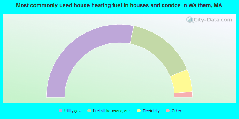
- 56.3%Utility gas
- 31.3%Fuel oil, kerosene, etc.
- 10.0%Electricity
- 1.7%Bottled, tank, or LP gas
- 0.5%Other fuel
- 0.2%Wood
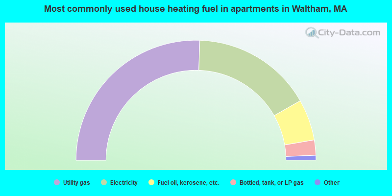
- 51.0%Utility gas
- 32.5%Electricity
- 11.1%Fuel oil, kerosene, etc.
- 4.1%Bottled, tank, or LP gas
- 0.7%Other fuel
- 0.6%No fuel used
Waltham compared to Massachusetts state average:
- Unemployed percentage below state average.
- Median age below state average.
- Foreign-born population percentage above state average.
- Length of stay since moving in significantly above state average.
- Number of college students above state average.
- Percentage of population with a bachelor's degree or higher above state average.
Waltham on our top lists:
- #10 on the list of "Top 101 cities with the highest average wind speeds (population 50,000+)"
- #11 on the list of "Top 101 cities with the smallest city-data.com crime index per police officer (population 50,000+)"
- #21 on the list of "Top 101 cities with largest percentage of males in occupations: business and financial operations occupations (population 50,000+)"
- #21 on the list of "Top 101 cities with the smallest humidity differences during a year (population 50,000+)"
- #21 on the list of "Top 101 cities with the smallest differences between morning and afternoon humidity (population 50,000+)"
- #23 on the list of "Top 101 cities with the biggest property tax revenues per resident (population 10,000+)"
- #26 on the list of "Top 101 cities with largest percentage of males in occupations: life, physical, and social science occupations (population 50,000+)"
- #30 on the list of "Top 101 cities with the lowest number of thefts per 100,000 residents (population 50,000+)"
- #32 on the list of "Top 101 cities with the lowest number of arson incidents per 100,000 residents (population 50,000+)"
- #35 on the list of "Top 101 cities with largest percentage of females in occupations: life, physical, and social science occupations (population 50,000+)"
- #36 on the list of "Top 101 cities with the largest percentage of likely lesbian couples (counted as self-reported female-female unmarried-partner households) (population 50,000+)"
- #36 on the list of "Top 100 cities with highest percentage of college students (pop. 50,000+)"
- #39 on the list of "Top 100 cities with highest median household income and median resident age less than 35 (pop. 50,000+)"
- #42 on the list of "Top 101 cities with the smallest precipitation differences during a year (population 50,000+)"
- #45 on the list of "Top 101 cities with the most residents born in Other Eastern Asia (population 500+)"
- #46 on the list of "Top 101 cities with largest percentage of females in industries: information (population 50,000+)"
- #51 on the list of "Top 101 cities with the lowest number of murders per 100,000 residents (population 50,000+)"
- #52 on the list of "Top 101 cities with largest percentage of females in occupations: computer and mathematical occupations (population 50,000+)"
- #53 on the list of "Top 101 cities with largest percentage of females in occupations: architecture and engineering occupations (population 50,000+)"
- #55 on the list of "Top 101 cities with largest percentage of females in industries: educational services (population 50,000+)"
- #72 (02451) on the list of "Top 101 zip codes with the most Internet business establishments in 2005"
- #96 (02451) on the list of "Top 101 zip codes with the most medium-big companies in 2005 (at least 100 employees)"
- #4 on the list of "Top 101 counties with the most Orthodox adherents"
- #7 on the list of "Top 101 counties with the most Catholic adherents"
- #7 on the list of "Top 101 counties with the most Mainline Protestant congregations"
- #7 on the list of "Top 101 counties with the most Orthodox congregations"
- #8 on the list of "Top 101 counties with the lowest percentage of residents that keep firearms around their homes"

|
|
Total of 3311 patent applications in 2008-2024.