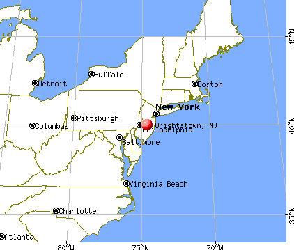
Wrightstown, New Jersey
Submit your own pictures of this borough and show them to the world
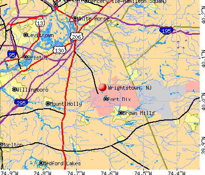
- OSM Map
- General Map
- Google Map
- MSN Map
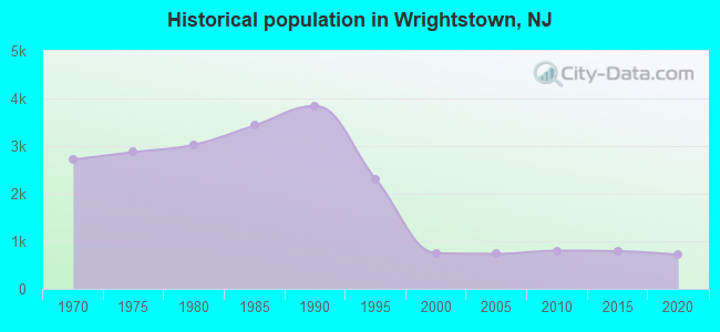
Population change since 2000: -4.1%
 |
| Males: 328 | |
| Females: 389 |
| Median resident age: | 30.3 years |
| New Jersey median age: | 40.4 years |
Zip codes: 08562.
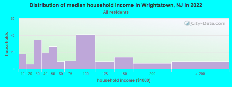
| Wrightstown: | $52,019 |
| NJ: | $96,346 |
Estimated per capita income in 2022: $32,798 (it was $14,489 in 2000)
Wrightstown borough income, earnings, and wages data
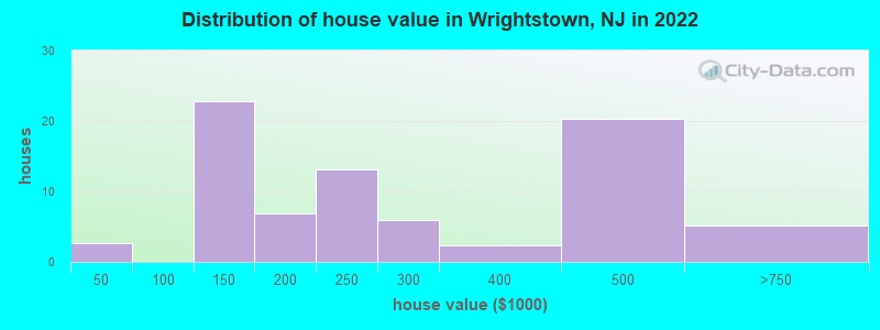
Estimated median house or condo value in 2022: $224,650 (it was $98,300 in 2000)
| Wrightstown: | $224,650 |
| NJ: | $428,900 |
Mean prices in 2022: all housing units: $265,720; detached houses: $276,781; townhouses or other attached units: $142,036
Median gross rent in 2022: $1,052.
(5.7% for White Non-Hispanic residents, 23.5% for Black residents, 3.4% for Hispanic or Latino residents, 18.5% for two or more races residents)
Detailed information about poverty and poor residents in Wrightstown, NJ
Compare current foreclosures near Wrightstown, NJ:
| Photo | Address | Area | Beds / Baths | Price | Details |
|---|---|---|---|---|---|

|
#1
Carlyle Dr
Wrightstown, NJ 08562
|
2,567 sq. feet
|
2 baths 3 beds |
show details | |

|
#2
Wrightstown Sykesville Rd Unit 148
Wrightstown, NJ 08562
|
- sq. feet
|
- baths - beds |
show details | |

|
#3
Chesterfield Arneytown Rd
Wrightstown, NJ 08562
|
- sq. feet
|
- baths - beds |
show details | |

|
#4
Meany Rd
Wrightstown, NJ 08562
|
- sq. feet
|
- baths - beds |
show details | |

|
#5
Wrightstown Sykesville Rd Unit 84
Wrightstown, NJ 08562
|
- sq. feet
|
- baths - beds |
show details | |

|
#6
Provinceline Rd
Wrightstown, NJ 08562
|
- sq. feet
|
- baths - beds |
show details | |

|
#7
Sumach St
Browns Mills, NJ 08015
|
1,274 sq. feet
|
1 baths 3 beds |
$299,900
|
show details |

|
#8
Farragut Ct
Willingboro, NJ 08046
|
954 sq. feet
|
1 baths 2 beds |
$174,900
|
show details |

|
#9
Brunswick Ave
Trenton, NJ 08618
|
1,088 sq. feet
|
1 baths 2 beds |
$74,900
|
show details |

|
#10
Foxglove Dr
Riverside, NJ 08075
|
840 sq. feet
|
1 baths 2 beds |
$113,683
|
show details |
| Photo | Address | Area | Beds / Baths | Price | Details |
|---|---|---|---|---|---|

|
#11
Arneys Mount Rd
Pemberton, NJ 08068
|
2,514 sq. feet
|
2 baths 3 beds |
$399,000
|
show details |

|
#12
N Cedar St
Bristol, PA 19007
|
841 sq. feet
|
1 baths 1 beds |
$315,500
|
show details |

|
#13
Bunker Hill Ave
Trenton, NJ 08648
|
840 sq. feet
|
1 baths 2 beds |
$275,000
|
show details |

|
#14
Eleanor Dr
Wrightstown, NJ 08562
|
- sq. feet
|
- baths - beds |
show details | |

|
#15
Monmouth Rd
Wrightstown, NJ 08562
|
- sq. feet
|
- baths - beds |
show details | |

|
#16
Larrison Rd
Wrightstown, NJ 08562
|
- sq. feet
|
- baths - beds |
show details | |

|
#17
Francis St
Wrightstown, NJ 08562
|
- sq. feet
|
- baths - beds |
show details | |

|
#18
Chesterfield Jacobstown Rd
Wrightstown, NJ 08562
|
- sq. feet
|
- baths - beds |
show details | |

|
#19
Fort Dix St
Wrightstown, NJ 08562
|
- sq. feet
|
- baths - beds |
show details | |

|
#20
Chesterfield Jacobstown Rd
Wrightstown, NJ 08562
|
- sq. feet
|
- baths - beds |
show details |
| Photo | Address | Area | Beds / Baths | Price | Details |
|---|---|---|---|---|---|

|
#21
Magnolia Rd
Pemberton, NJ 08068
|
- sq. feet
|
2 baths 4 beds |
$306,800
|
show details |

|
#22
Portsmouth Ct
Bensalem, PA 19020
|
1,400 sq. feet
|
1 baths 3 beds |
show details | |

|
#23
Rocky Pool Ln
Levittown, PA 19055
|
992 sq. feet
|
2 baths - beds |
$205,046
|
show details |

|
#24
Ginger Ct
Mount Laurel, NJ 08054
|
1,133 sq. feet
|
1 baths 1 beds |
show details | |

|
#25
As Garfield Street
Croydon, PA Array
|
- sq. feet
|
- baths - beds |
$440,537
|
show details |

|
#26
Twilight Ln
Willingboro, NJ 08046
|
3,429 sq. feet
|
3 baths 5 beds |
show details | |

|
#27
Springhouse Ct
Bordentown, NJ 08505
|
3,040 sq. feet
|
2 baths 5 beds |
show details | |

|
#28
Montana Trl
Browns Mills, NJ 08015
|
1,844 sq. feet
|
2 baths 4 beds |
show details | |

|
#29
Marshall Ave
Trenton, NJ 08610
|
672 sq. feet
|
1 baths 3 beds |
show details | |

|
#30
Glenmar Rd
Fairless Hills, PA 19030
|
1,272 sq. feet
|
1 baths 3 beds |
show details |
| Photo | Address | Area | Beds / Baths | Price | Details |
|---|---|---|---|---|---|

|
#31
Franklin Ave
Croydon, PA 19021
|
1,559 sq. feet
|
2 baths 3 beds |
show details | |

|
#32
Fairfax Ct
Bordentown, NJ 08505
|
1,296 sq. feet
|
2 baths 3 beds |
show details | |

|
#33
Route 206
Trenton, NJ 08610
|
1,808 sq. feet
|
2 baths 3 beds |
show details | |

|
#34
Groendyke Cir
Perrineville, NJ 08535
|
- sq. feet
|
3 baths 6 beds |
show details | |

|
#35
Mount Holly Ave
Mount Holly, NJ 08060
|
1,512 sq. feet
|
1 baths 3 beds |
show details | |

|
#36
Plumtree Rd
Levittown, PA 19056
|
1,513 sq. feet
|
2 baths 4 beds |
show details | |

|
#37
First Avenue
Croydon, PA 19021
|
1,320 sq. feet
|
2 baths 3 beds |
show details | |

|
#38
Mulberry St
Bristol, PA 19007
|
1,950 sq. feet
|
2 baths 4 beds |
show details | |

|
#39
Foy Dr
Trenton, NJ 08690
|
2,416 sq. feet
|
3 baths 4 beds |
show details | |

|
#40
Stoneham Dr
Riverside, NJ 08075
|
4,722 sq. feet
|
2 baths 4 beds |
show details |
| Photo | Address | Area | Beds / Baths | Price | Details |
|---|---|---|---|---|---|

|
#41
Front St
New Egypt, NJ 08533
|
1,224 sq. feet
|
2 baths 3 beds |
show details | |

|
#42
Bayberry Ln
Willingboro, NJ 08046
|
3,485 sq. feet
|
3 baths 6 beds |
show details | |

|
#43
Gaylord Cir
Willingboro, NJ 08046
|
1,397 sq. feet
|
2 baths 3 beds |
show details | |

|
#44
Larchmont Dr
Riverside, NJ 08075
|
1,509 sq. feet
|
2 baths 4 beds |
show details | |

|
#45
N Pennsylvania Ave
Morrisville, PA 19067
|
- sq. feet
|
2 baths 6 beds |
show details | |

|
#46
Grant Ct
Columbus, NJ 08022
|
2,646 sq. feet
|
3 baths 4 beds |
show details | |

|
#47
New Jersey Rd
Browns Mills, NJ 08015
|
1,803 sq. feet
|
2 baths 4 beds |
show details | |

|
#48
Garfield Ave
Croydon, PA 19021
|
2,017 sq. feet
|
2 baths 3 beds |
show details | |

|
#49
Stacy St
Burlington, NJ 08016
|
1,450 sq. feet
|
1 baths 4 beds |
show details | |

|
Check over 1 million property listings on Foreclosure.com!
|
browse all offers | |||


- 18739.7%White alone
- 18739.7%Black alone
- 6413.6%Hispanic
- 224.7%Two or more races
- 102.1%Asian alone
- 10.2%Other race alone
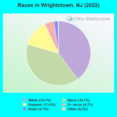
Races in Wrightstown detailed stats: ancestries, foreign born residents, place of birth
According to our research of New Jersey and other state lists, there were 2 registered sex offenders living in Wrightstown, New Jersey as of April 19, 2024.
The ratio of all residents to sex offenders in Wrightstown is 381 to 1.
 Recent articles from our blog. Our writers, many of them Ph.D. graduates or candidates, create easy-to-read articles on a wide variety of topics.

 | Desirable Community Towns near Fort Dix (12 replies) |
| Easy commute to Hopewell, NJ? (We are Texans) (3 replies) |
| Wrightstown NJ (22 replies) |
| Browns mills/wrightstown/ Cookstown (0 replies) |
| Apartments In Burlington County Area (2 replies) |
| Wrightstown? (0 replies) |
Latest news from Wrightstown, NJ collected exclusively by city-data.com from local newspapers, TV, and radio stations
Ancestries: Polish (7.4%), Jamaican (4.5%), Irish (4.1%), Italian (2.5%), English (2.1%), American (1.6%).
Current Local Time: EST time zone
Elevation: 185 feet
Land area: 1.76 square miles.
Population density: 408 people per square mile (low).
53 residents are foreign born (4.7% Africa, 2.8% Asia, 2.3% Latin America, 1.5% Europe).
| This borough: | 11.3% |
| New Jersey: | 23.2% |
Median real estate property taxes paid for housing units with mortgages in 2022: $4,161 (1.7%)
Median real estate property taxes paid for housing units with no mortgage in 2022: $4,194 (2.9%)
Nearest city with pop. 50,000+: Levittown, PA  (14.7 miles , pop. 53,966).
Nearest city with pop. 200,000+: Philadelphia, PA (27.8 miles , pop. 1,517,550).
Nearest cities:
), ), ), )Latitude: 40.03 N, Longitude: 74.62 W
Daytime population change due to commuting: +3,476 (+737.5%)
Workers who live and work in this borough: 66 (29.5%)
Area code commonly used in this area: 609

Wrightstown, New Jersey accommodation & food services, waste management - Economy and Business Data
| Here: | 3.9% |
| New Jersey: | 4.5% |
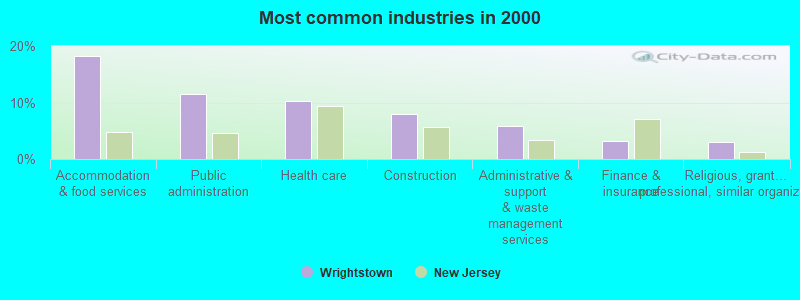
- Accommodation & food services (18.3%)
- Public administration (11.5%)
- Health care (10.3%)
- Construction (8.0%)
- Administrative & support & waste management services (5.9%)
- Finance & insurance (3.2%)
- Religious, grantmaking, civic, professional, similar organizations (2.9%)
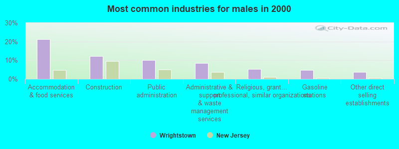
- Accommodation & food services (21.3%)
- Construction (12.2%)
- Public administration (10.1%)
- Administrative & support & waste management services (8.5%)
- Religious, grantmaking, civic, professional, similar organizations (5.3%)
- Gasoline stations (4.8%)
- Other direct selling establishments (3.7%)
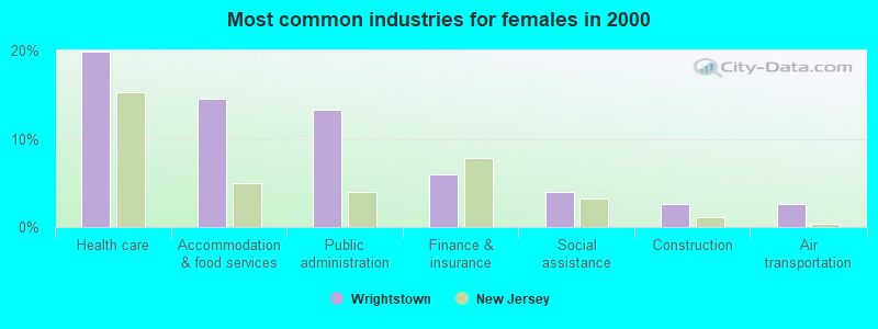
- Health care (19.9%)
- Accommodation & food services (14.6%)
- Public administration (13.2%)
- Finance & insurance (6.0%)
- Social assistance (4.0%)
- Construction (2.6%)
- Air transportation (2.6%)
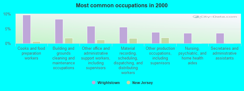
- Cooks and food preparation workers (9.7%)
- Building and grounds cleaning and maintenance occupations (8.3%)
- Other office and administrative support workers, including supervisors (5.9%)
- Material recording, scheduling, dispatching, and distributing workers (5.6%)
- Other production occupations, including supervisors (3.8%)
- Nursing, psychiatric, and home health aides (3.5%)
- Secretaries and administrative assistants (3.5%)
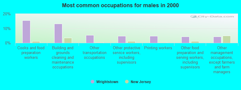
- Cooks and food preparation workers (15.4%)
- Building and grounds cleaning and maintenance occupations (13.3%)
- Other transportation occupations (5.3%)
- Other protective service workers, including supervisors (4.8%)
- Printing workers (4.8%)
- Other food preparation and serving workers, including supervisors (4.3%)
- Other management occupations, except farmers and farm managers (4.3%)
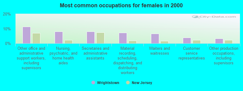
- Other office and administrative support workers, including supervisors (11.3%)
- Nursing, psychiatric, and home health aides (7.9%)
- Secretaries and administrative assistants (7.9%)
- Material recording, scheduling, dispatching, and distributing workers (7.3%)
- Waiters and waitresses (6.6%)
- Customer service representatives (4.0%)
- Other production occupations, including supervisors (3.3%)
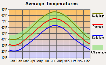
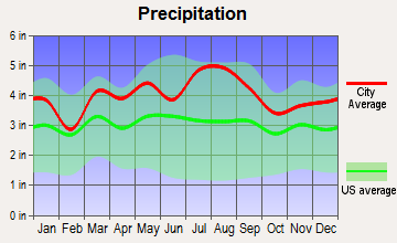
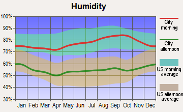
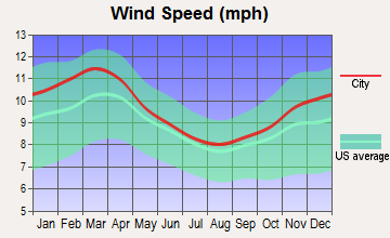
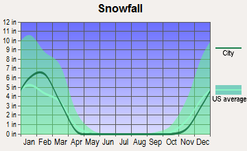
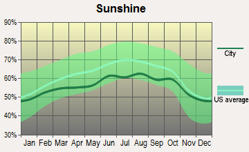
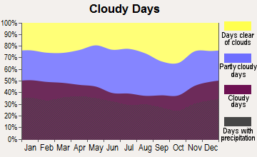
Average climate in Wrightstown, New Jersey
Based on data reported by over 4,000 weather stations
(lower is better)
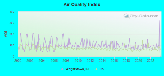
Air Quality Index (AQI) level in 2023 was 125. This is significantly worse than average.
| City: | 125 |
| U.S.: | 73 |
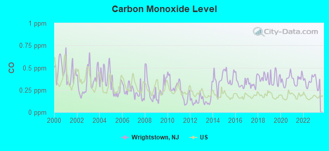
Carbon Monoxide (CO) [ppm] level in 2022 was 0.347. This is worse than average. Closest monitor was 10.2 miles away from the city center.
| City: | 0.347 |
| U.S.: | 0.251 |
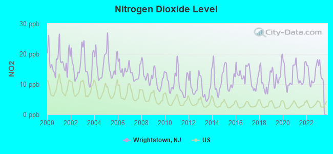
Nitrogen Dioxide (NO2) [ppb] level in 2022 was 13.2. This is significantly worse than average. Closest monitor was 2.3 miles away from the city center.
| City: | 13.2 |
| U.S.: | 5.1 |
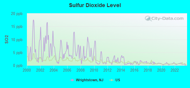
Sulfur Dioxide (SO2) [ppb] level in 2022 was 0.645. This is significantly better than average. Closest monitor was 2.3 miles away from the city center.
| City: | 0.645 |
| U.S.: | 1.515 |

Ozone [ppb] level in 2023 was 32.0. This is about average. Closest monitor was 9.7 miles away from the city center.
| City: | 32.0 |
| U.S.: | 33.3 |
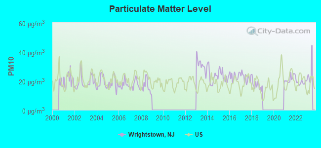
Particulate Matter (PM10) [µg/m3] level in 2022 was 18.9. This is about average. Closest monitor was 14.7 miles away from the city center.
| City: | 18.9 |
| U.S.: | 19.2 |
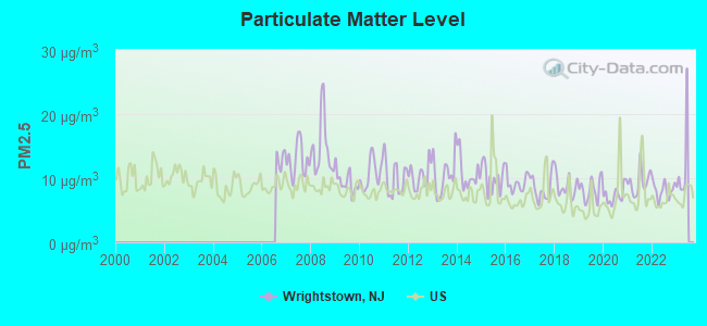
Particulate Matter (PM2.5) [µg/m3] level in 2022 was 8.12. This is about average. Closest monitor was 14.7 miles away from the city center.
| City: | 8.12 |
| U.S.: | 8.11 |
Tornado activity:
Wrightstown-area historical tornado activity is near New Jersey state average. It is 27% smaller than the overall U.S. average.
On 7/21/1983, a category F3 (max. wind speeds 158-206 mph) tornado 31.0 miles away from the Wrightstown borough center caused between $500,000 and $5,000,000 in damages.
On 10/18/1990, a category F3 tornado 31.9 miles away from the borough center injured 8 people and caused between $500,000 and $5,000,000 in damages.
Earthquake activity:
Wrightstown-area historical earthquake activity is significantly above New Jersey state average. It is 67% smaller than the overall U.S. average.On 8/23/2011 at 17:51:04, a magnitude 5.8 (5.8 MW, Depth: 3.7 mi, Class: Moderate, Intensity: VI - VII) earthquake occurred 230.9 miles away from the city center
On 1/16/1994 at 01:49:16, a magnitude 4.6 (4.6 MB, 4.6 LG, Depth: 3.1 mi, Class: Light, Intensity: IV - V) earthquake occurred 77.5 miles away from the city center
On 10/7/1983 at 10:18:46, a magnitude 5.3 (5.1 MB, 5.3 LG, 5.1 ML) earthquake occurred 271.6 miles away from the city center
On 1/16/1994 at 00:42:43, a magnitude 4.2 (4.2 MB, 4.0 LG, Depth: 3.1 mi) earthquake occurred 75.9 miles away from Wrightstown center
On 11/30/2017 at 21:47:31, a magnitude 4.1 (4.1 MW, Depth: 6.1 mi) earthquake occurred 72.1 miles away from Wrightstown center
On 4/20/2002 at 10:50:47, a magnitude 5.3 (5.3 ML, Depth: 3.0 mi) earthquake occurred 313.5 miles away from Wrightstown center
Magnitude types: regional Lg-wave magnitude (LG), body-wave magnitude (MB), local magnitude (ML), moment magnitude (MW)
Natural disasters:
The number of natural disasters in Burlington County (27) is a lot greater than the US average (15).Major Disasters (Presidential) Declared: 16
Emergencies Declared: 9
Causes of natural disasters: Hurricanes: 6, Snowstorms: 6, Floods: 4, Storms: 4, Winter Storms: 4, Blizzards: 2, Heavy Rains: 2, Water Shortages: 2, Fire: 1, Tornado: 1, Tropical Storm: 1, Wind: 1, Other: 3 (Note: some incidents may be assigned to more than one category).

Hospitals and medical centers near Wrightstown:
- DEBORAH HEART AND LUNG CENTER Acute Care Hospitals (about 5 miles away; BROWNS MILLS, NJ)
- VIRTUA MEMORIAL HOSPITAL OF BURLINGTON COUNTY Acute Care Hospitals (about 10 miles away; MOUNT HOLLY, NJ)
- VIRTUA HEALTH AND REHAB MT HOLLY (Nursing Home, about 10 miles away; LUMBERTON, NJ)
- UCPA OF QUEENS (Hospital, about 11 miles away; BELLEROSE, NY)
- DVA LUMBERTON DIALYSIS CTR (Dialysis Facility, about 11 miles away; LUMBERTON, NJ)
- MASONIC HOME AND CHARITY FOUNDATION (Nursing Home, about 12 miles away; BURLINGTON, NJ)
- MASONIC HOME OF NEW JERSEY (Nursing Home, about 12 miles away; BURLINGTON, NJ)
Airports located in Wrightstown:
Amtrak stations near Wrightstown:
- 15 miles: TRENTON (72 S. CLINTON AVE.) . Services: ticket office, fully wheelchair accessible, enclosed waiting area, public restrooms, public payphones, snack bar, ATM, paid short-term parking, paid long-term parking, car rental agency, taxi stand, public transit connection.
- 20 miles: PRINCETON JUNCTION (WALLACE RD.) . Services: ticket office, fully wheelchair accessible, enclosed waiting area, public restrooms, snack bar, paid short-term parking, paid long-term parking, call for car rental service, taxi stand, public transit connection.
Colleges/universities with over 2000 students nearest to Wrightstown:
- Burlington County College (about 5 miles; Pemberton, NJ; Full-time enrollment: 7,928)
- Thomas Edison State College (about 16 miles; Trenton, NJ; FT enrollment: 4,972)
- Mercer County Community College (about 16 miles; West Windsor, NJ; FT enrollment: 5,728)
- The College of New Jersey (about 19 miles; Ewing, NJ; FT enrollment: 7,573)
- Rider University (about 19 miles; Lawrenceville, NJ; FT enrollment: 4,960)
- Strayer University-Pennsylvania (about 20 miles; Trevose, PA; FT enrollment: 2,027)
- Holy Family University (about 20 miles; Philadelphia, PA; FT enrollment: 2,305)
Public elementary/middle schools in Wrightstown:
- CLARENCE B. LAMB ELEMENTARY SCHOOL (Students: 343, Location: 46 SCHOOLHOUSE ROAD, Grades: 1-4)
- NEW HANOVER TOWNSHIP SCHOOL (Students: 162, Location: 122 FORT DIX STREET, Grades: PK-8)
- NORTH HANOVER TOWNSHIP UPPER ELEMENTARY SCHOOL (Location: 351 MONMOUTH ROAD, Grades: 5-6)
Points of interest:
Notable location: Wrightstown Volunteer Fire Company 1 (A). Display/hide its location on the map
Hotels: Days Innn (505 E Main), Days Inn McGuire Dix (507 East Main Street), Hilltop Motel (State Highway 68 North).
Drinking water stations with addresses in Wrightstown that have no violations reported:
- THE VIRGINIAN MOTEL (Population served: 52, Primary Water Source Type: Groundwater)
| This borough: | 2.6 people |
| New Jersey: | 2.7 people |
| This borough: | 61.2% |
| Whole state: | 69.3% |
| This borough: | 10.4% |
| Whole state: | 5.9% |
Likely homosexual households (counted as self-reported same-sex unmarried-partner households)
- Lesbian couples: 0.6% of all households
- Gay men: 0.0% of all households
For population 15 years and over in Wrightstown:
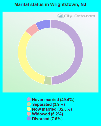
- Never married: 49.4%
- Now married: 32.8%
- Separated: 3.9%
- Widowed: 6.2%
- Divorced: 7.6%
For population 25 years and over in Wrightstown:
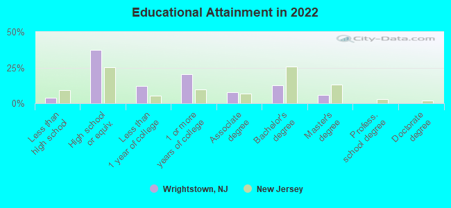
- High school or higher: 93.7%
- Bachelor's degree or higher: 17.7%
- Graduate or professional degree: 5.2%
- Unemployed: 6.9%
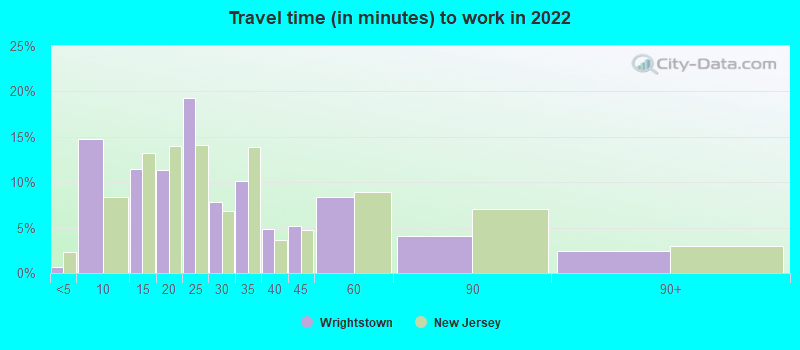
- Mean travel time to work (commute): 37.5 minutes
| Here: | 7.4 |
| New Jersey average: | 12.8 |
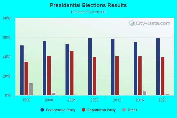
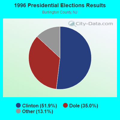
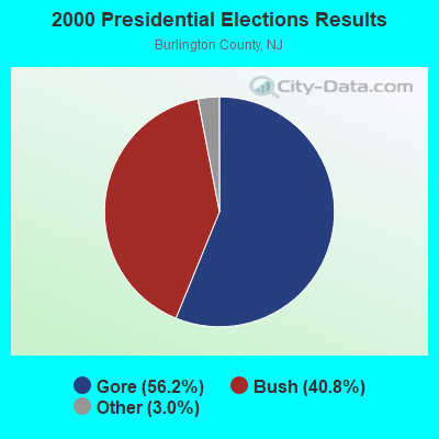
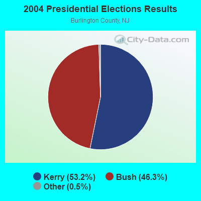
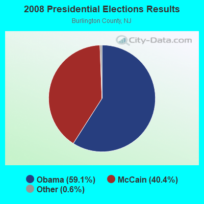
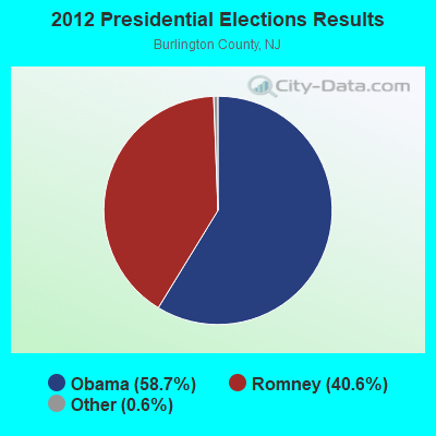
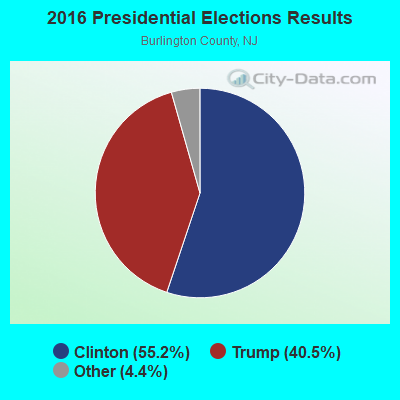
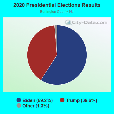
Graphs represent county-level data. Detailed 2008 Election Results
Religion statistics for Wrightstown, NJ (based on Burlington County data)
| Religion | Adherents | Congregations |
|---|---|---|
| Catholic | 111,334 | 22 |
| Mainline Protestant | 29,271 | 118 |
| Evangelical Protestant | 23,751 | 112 |
| Other | 13,995 | 32 |
| Black Protestant | 7,303 | 32 |
| Orthodox | 620 | 2 |
| None | 262,460 | - |
Food Environment Statistics:
| This county: | 1.88 / 10,000 pop. |
| New Jersey: | 2.90 / 10,000 pop. |
| Burlington County: | 0.07 / 10,000 pop. |
| State: | 0.06 / 10,000 pop. |
| Burlington County: | 1.68 / 10,000 pop. |
| State: | 1.76 / 10,000 pop. |
| Burlington County: | 0.83 / 10,000 pop. |
| New Jersey: | 0.81 / 10,000 pop. |
| Burlington County: | 5.09 / 10,000 pop. |
| State: | 7.15 / 10,000 pop. |
| Burlington County: | 8.9% |
| New Jersey: | 8.3% |
| Burlington County: | 26.0% |
| New Jersey: | 23.3% |
| This county: | 14.7% |
| New Jersey: | 18.0% |
Health and Nutrition:
| Wrightstown: | 47.9% |
| State: | 50.6% |
| Wrightstown: | 46.2% |
| New Jersey: | 48.5% |
| This city: | 28.7 |
| New Jersey: | 28.5 |
| Wrightstown: | 20.9% |
| New Jersey: | 20.0% |
| This city: | 12.2% |
| New Jersey: | 11.1% |
| Here: | 6.7 |
| State: | 6.8 |
| Wrightstown: | 32.4% |
| State: | 33.6% |
| Here: | 56.3% |
| New Jersey: | 56.9% |
| Wrightstown: | 81.7% |
| New Jersey: | 80.0% |
More about Health and Nutrition of Wrightstown, NJ Residents
| Local government employment and payroll (March 2022) | |||||
| Function | Full-time employees | Monthly full-time payroll | Average yearly full-time wage | Part-time employees | Monthly part-time payroll |
|---|---|---|---|---|---|
| Water Supply | 4 | $16,769 | $50,307 | 2 | $3,011 |
| Streets and Highways | 2 | $5,834 | $35,004 | 1 | $183 |
| Other Government Administration | 2 | $9,265 | $55,590 | 0 | $0 |
| Fire - Other | 1 | $5,398 | $64,776 | 0 | $0 |
| Financial Administration | 0 | $0 | 1 | $827 | |
| Totals for Government | 9 | $37,266 | $49,688 | 4 | $4,021 |
Wrightstown government finances - Expenditure in 2017 (per resident):
- Current Operations - General - Other: $231,000 ($322.18)
Central Staff Services: $147,000 ($205.02)
Financial Administration: $110,000 ($153.42)
Regular Highways: $95,000 ($132.50)
Local Fire Protection: $86,000 ($119.94)
Solid Waste Management: $41,000 ($57.18)
Judicial and Legal Services: $37,000 ($51.60)
Protective Inspection and Regulation - Other: $23,000 ($32.08)
Public Welfare - Other: $22,000 ($30.68)
Health - Other: $14,000 ($19.53)
General Public Buildings: $11,000 ($15.34)
Police Protection: $6,000 ($8.37)
Parks and Recreation: $1,000 ($1.39)
- General - Interest on Debt: $42,000 ($58.58)
- Total Salaries and Wages: $360,000 ($502.09)
Wrightstown government finances - Revenue in 2017 (per resident):
- Local Intergovernmental - Other: $65,000 ($90.66)
- Miscellaneous - Sale of Property: $13,000 ($18.13)
Fines and Forfeits: $5,000 ($6.97)
- State Intergovernmental - Electric Utilities: $287,000 ($400.28)
General Local Government Support: $125,000 ($174.34)
Public Welfare: $17,000 ($23.71)
Health and Hospitals: $8,000 ($11.16)
- Tax - Property: $515,000 ($718.27)
Other Selective Sales: $25,000 ($34.87)
Occupation and Business License - Other: $23,000 ($32.08)
Other License: $14,000 ($19.53)
Alcoholic Beverage License: $5,000 ($6.97)
Public Utility License: $4,000 ($5.58)
Wrightstown government finances - Debt in 2017 (per resident):
- Long Term Debt - Beginning Outstanding - Unspecified Public Purpose: $1,060,000 ($1478.38)
Outstanding Unspecified Public Purpose: $1,015,000 ($1415.62)
Retired Unspecified Public Purpose: $45,000 ($62.76)
- Short Term Debt Outstanding - Beginning: $128,000 ($178.52)
End of Fiscal Year: $115,000 ($160.39)
Wrightstown government finances - Cash and Securities in 2017 (per resident):
- Other Funds - Cash and Securities: $533,000 ($743.38)
7.18% of this county's 2021 resident taxpayers lived in other counties in 2020 ($71,287 average adjusted gross income)
| Here: | 7.18% |
| New Jersey average: | 6.70% |
0.07% of residents moved from foreign countries ($594 average AGI)
Burlington County: 0.07% New Jersey average: 0.01%
Top counties from which taxpayers relocated into this county between 2020 and 2021:
| from Camden County, NJ | |
| from Mercer County, NJ | |
| from Philadelphia County, PA |
6.64% of this county's 2020 resident taxpayers moved to other counties in 2021 ($102,719 average adjusted gross income)
| Here: | 6.64% |
| New Jersey average: | 7.02% |
0.08% of residents moved to foreign countries ($611 average AGI)
Burlington County: 0.08% New Jersey average: 0.02%
Top counties to which taxpayers relocated from this county between 2020 and 2021:
| to Camden County, NJ | |
| to Mercer County, NJ | |
| to Philadelphia County, PA |
| Businesses in Wrightstown, NJ | ||||
| Name | Count | Name | Count | |
|---|---|---|---|---|
| 7-Eleven | 1 | Papa John's Pizza | 1 | |
| Days Inn | 1 | Rite Aid | 1 | |
| Dunkin Donuts | 1 | Subway | 1 | |
| FedEx | 1 | Taco Bell | 1 | |
| H&R Block | 1 | U-Haul | 2 | |
| KFC | 1 | Wendy's | 1 | |
| McDonald's | 1 | |||
Strongest AM radio stations in Wrightstown:
- WPHT (1210 AM; 50 kW; PHILADELPHIA, PA; Owner: INFINITY BROADCASTING OPERATIONS, INC.)
- WWJZ (640 AM; 50 kW; MOUNT HOLLY, NJ; Owner: ABC, INC.)
- WPEN (950 AM; 50 kW; PHILADELPHIA, PA; Owner: GREATER PHILADELPHIA RADIO, INC.)
- KYW (1060 AM; 50 kW; PHILADELPHIA, PA; Owner: INFINITY BROADCASTING OPERATIONS, INC.)
- WZZD (990 AM; 50 kW; PHILADELPHIA, PA; Owner: PENNSYLVANIA MEDIA ASSOCIATES, INC.)
- WIFI (1460 AM; 5 kW; FLORENCE, NJ; Owner: REAL LIFE BROADCASTING)
- WVCH (740 AM; 50 kW; CHESTER, PA; Owner: WVCH COMMUNICATIONS, INC.)
- WNWR (1540 AM; 50 kW; PHILADELPHIA, PA)
- WMCA (570 AM; 50 kW; NEW YORK, NY; Owner: SALEM MEDIA OF NEW YORK, LLC)
- WOR (710 AM; 50 kW; NEW YORK, NY; Owner: BUCKLEY BROADCASTING CORPORATION)
- WOBM (1160 AM; 9 kW; LAKEWOOD TOWNSHIP, NJ; Owner: NORTH SHORE BROADCASTING CORP.)
- WABC (770 AM; 50 kW; NEW YORK, NY; Owner: WABC-AM RADIO, INC.)
- WFAN (660 AM; 50 kW; NEW YORK, NY; Owner: INFINITY BROADCASTING OPERATIONS, INC.)
Strongest FM radio stations in Wrightstown:
- WKXW-FM (101.5 FM; TRENTON, NJ; Owner: MILLENNIUM CENTRAL NEW JERSEY LICENSE HOLDCO, LLC)
- WNJT-FM (88.1 FM; TRENTON, NJ; Owner: NEW JERSEY PUBLIC BRD/CST AUTHORITY)
- WPRB (103.3 FM; PRINCETON, NJ; Owner: PRINCETON BROADCASTING SERVICE, INC.)
- WNJS-FM (88.1 FM; BERLIN, NJ; Owner: NEW JERSEY PUBLIC BROADCASTING AUTHORITY)
- WMGK (102.9 FM; PHILADELPHIA, PA; Owner: GREATER PHILADELPHIA RADIO, INC.)
- WMWX (95.7 FM; PHILADELPHIA, PA; Owner: GREATER PHILADELPHIA RADIO, INC.)
- WPST (97.5 FM; TRENTON, NJ; Owner: NASSAU BROADCASTING II, L.L.C.)
- WOGL (98.1 FM; PHILADELPHIA, PA; Owner: INFINITY BROADCASTING OPERATIONS, INC.)
- WMMR (93.3 FM; PHILADELPHIA, PA; Owner: GREATER BOSTON RADIO, INC.)
- WBEB (101.1 FM; PHILADELPHIA, PA; Owner: WEAZ-FM RADIO, INC.)
- WRTI (90.1 FM; PHILADELPHIA, PA; Owner: TEMPLE UNIV. OF THE COMMONWEALTH, ET)
- WSNI-FM (104.5 FM; PHILADELPHIA, PA; Owner: AMFM RADIO LICENSES, L.L.C.)
- WPHI-FM (103.9 FM; JENKINTOWN, PA; Owner: RADIO ONE LICENSES, LLC)
- WTHK (94.5 FM; TRENTON, NJ; Owner: NASSAU BROADCASTING II, L.L.C.)
- WHYY-FM (90.9 FM; PHILADELPHIA, PA; Owner: WHYY, INC.)
- WXTU (92.5 FM; PHILADELPHIA, PA; Owner: WXTU LICENSE LIMITED PARTNERSHIP)
- WXPN (88.5 FM; PHILADELPHIA, PA; Owner: TRUSTEES OF THE UNIVERSITY OF PENNA.)
- W220AG (91.9 FM; LAWRENCEVILLE, ETC., NJ; Owner: BUX-MONT EDUCATIONAL RADIO ASSOC.)
- WYSP (94.1 FM; PHILADELPHIA, PA; Owner: INFINITY BROADCASTING OPERATIONS, INC.)
- WDAS-FM (105.3 FM; PHILADELPHIA, PA; Owner: AMFM RADIO LICENSES, L.L.C.)
TV broadcast stations around Wrightstown:
- WNJT (Channel 52; TRENTON, NJ; Owner: NEW JERSEY PUBLIC BROADCASTING AUTHORITY)
- WUVP (Channel 65; VINELAND, NJ; Owner: UNIVISION PHILADELPHIA LLC)
- KYW-TV (Channel 3; PHILADELPHIA, PA; Owner: CBS BROADCASTING INC.)
- WNJN (Channel 50; MONTCLAIR, NJ; Owner: NEW JERSEY PUBLIC B/CNG AUTHORITY)
- WNJS (Channel 23; CAMDEN, NJ; Owner: NEW JERSEY PUBLIC BROADCASTING AUTHORITY)
- WPHL-TV (Channel 17; PHILADELPHIA, PA; Owner: TRIBUNE TELEVISION COMPANY)
- WPVI-TV (Channel 6; PHILADELPHIA, PA; Owner: ABC, INC.)
- WPSG (Channel 57; PHILADELPHIA, PA; Owner: VIACOM STATIONS GROUP OF PHILADELPHIA INC.)
- WPPX (Channel 61; WILMINGTON, DE; Owner: PAXSON PHILADELPHIA LICENSE, INC.)
- WCAU (Channel 10; PHILADELPHIA, PA; Owner: NBC SUBSIDIARY (WCAU-TV), L.P.)
- WWJT-LP (Channel 7; PHILADELPHIA, PA; Owner: PHILADELPHIA TELEVISION NETWORK, INC)
- WPSJ-LP (Channel 8; HAMMONTON, ETC., NJ; Owner: ENGLE BROADCASTING)
- WGTW (Channel 48; BURLINGTON, NJ; Owner: BRUNSON COMMUNICATIONS, INC.)
- WYBE (Channel 35; PHILADELPHIA, PA; Owner: INDEPENDENCE PUBLIC MEDIA OF PHILADELPHIA, INC.)
- WWSI (Channel 62; ATLANTIC CITY, NJ; Owner: HISPANIC BROADCASTERS OF PHILADELPHIA, L.L.C.)
- WELL-LP (Channel 8; WILLOW GROVE, ETC., PA; Owner: WORD OF GOD FELLOWSHIP, INC.)
- WHYY-TV (Channel 12; WILMINGTON, DE; Owner: WHYY, INC.)
- WTXF-TV (Channel 29; PHILADELPHIA, PA; Owner: FOX TV STATIONS OF PHILADELPHIA)
- WMCN-TV (Channel 53; ATLANTIC CITY, NJ; Owner: LENFEST BROADCASTING, LLC)
- W25AW (Channel 25; TRENTON, NJ; Owner: WZBN TV, INC.)
Wrightstown fatal accident list:
Mar 8, 2004 03:14 AM, Saylors Pond Rd, Vehicles: 1, Persons: 1, Fatalities: 1, Drunk persons involved: 1
Jun 26, 1998 06:44 PM, Sr-68, Vehicles: 1, Persons: 1, Fatalities: 1
Aug 3, 1980 07:49 AM, Vehicles: 1, Persons: 1, Fatalities: 1
Oct 22, 1976 10:20 PM, Persons: 1, Fatalities: 1
Oct 22, 1975 10:20 PM, Persons: 1, Fatalities: 1
- National Bridge Inventory (NBI) Statistics
- 1Number of bridges
- 3ft / 1.3mTotal length
- $228,000Total costs
- 230Total average daily traffic
- 6Total average daily truck traffic
- 285Total future (year 2040) average daily traffic
FCC Registered Antenna Towers:
28 (See the full list of FCC Registered Antenna Towers in Wrightstown)FCC Registered Private Land Mobile Towers:
1- Sykesville Rd Lot 7 Blk 602 (Lat: 40.044278 Lon: -74.616278), Structure height: 32 m, Call Sign: WNNY704, Licensee ID: L00120834,
Assigned Frequencies: 929.987 MHz, Grant Date: 09/23/1998, Expiration Date: 09/23/2008, Cancellation Date: 04/29/2003, Registrant: Map Paging Co Inc, 840 Greenbrier Cir Ste 202, Chesapeake, VA 23320, Phone: (804) 424-1191
FCC Registered Broadcast Land Mobile Towers:
6- Martha Ave (Lat: 40.037611 Lon: -74.603778), Call Sign: KNO383, Licensee ID: L00046808,
Assigned Frequencies: 501.137 MHz, Grant Date: 02/12/2005, Expiration Date: 02/13/2015, Cancellation Date: 04/18/2015, Registrant: City Of New Hanover, Cookstown, NJ 08511, Phone: (609) 758-7149
- Chesterfield Sykesville Rd 1/2 Mi N Of Black Rd (Lat: 40.086778 Lon: -74.618222), Call Sign: KJC577,
Assigned Frequencies: 154.490 MHz, Grant Date: 03/14/2002, Expiration Date: 05/11/2012, Cancellation Date: 07/14/2012, Registrant: Business Radio Licensing, 26941 Cabot Rd., Suite 134, Laguna Hills, CA 92653, Phone: (949) 348-8510
- 62 Fort Dix Street (Lat: 40.027500 Lon: -74.631111), Call Sign: WPVZ987, Licensee ID: L00536557,
Assigned Frequencies: 466.612 MHz, 466.762 MHz, Grant Date: 09/24/2002, Expiration Date: 09/24/2012, Cancellation Date: 11/24/2012, Certifier: Denise M Branca Ms., Registrant: New Jersey Restaurants, Lp., 14 Balligomingo Road, Conshohocken, PA 19428, Phone: (610) 520-1000, Fax: (610) 260-1510, Email:
- Mid-State Correctional Facility (Lat: 39.997472 Lon: -74.584000), Type: Building, Structure height: 9 m, Overall height: 10 m, Call Sign: WQAI219,
Assigned Frequencies: 453.762 MHz, Grant Date: 03/12/2024, Expiration Date: 06/04/2034, Certifier: John H Moore, Registrant: Nj Dept Of Corrections, 5 Whittlesey Road, Trenton, NJ 08625, Phone: (609) 292-4036, Fax: (609) 777-1656, Email:
- 102 East Main Street (Lat: 40.035833 Lon: -74.615833), Call Sign: WQBQ356,
Assigned Frequencies: 30.8400 MHz, 154.540 MHz, 33.4000 MHz, 33.1600 MHz, 31.2400 MHz, 468.487 MHz, 468.762 MHz, 468.837 MHz, 469.462 MHz, 469.637 MHz... (+22 more), Grant Date: 11/22/2004, Expiration Date: 11/22/2014, Cancellation Date: 01/24/2015, Certifier: Beth Cotner, Registrant: Dolfen Consulting Group, 95 Willow Lane, Bristol, IL 60512-9711, Phone: (630) 553-5886, Fax: (630) 566-1755, Email:
- Lat: 40.072528 Lon: -74.585139, Call Sign: WQOQ510,
Assigned Frequencies: 462.450 MHz, 463.337 MHz, 464.937 MHz, 467.450 MHz, 469.937 MHz, 462.450 MHz, 463.337 MHz, 464.937 MHz, 467.450 MHz, 469.937 MHz, Grant Date: 12/16/2021, Expiration Date: 12/22/2031, Certifier: Mathew J Emandes, Registrant: Philip M Casciano Associates, Inc. Dba Pmc Associates, 8 Crown Plaza Suite 106, Hazlet, NJ 07730, Phone: (732) 888-9300, Fax: (732) 888-9388, Email:
FCC Registered Microwave Towers:
2- Wright, Lat: 40.074444 Lon: -74.619722, Call Sign: WPQQ987, Licensee ID: L00761386,
Assigned Frequencies: 952.281 MHz, Grant Date: 08/24/2000, Expiration Date: 08/24/2010, Cancellation Date: 04/10/2006, Certifier: Thomas M O'Flynn, Registrant: Pseg Services Corporation
- Mobile, Lat: 40.068000 Lon: -74.628056, Call Sign: WQDJ323,
Assigned Frequencies: 952.106 MHz, 952.106 MHz, Grant Date: 07/07/2015, Expiration Date: 09/09/2025, Certifier: Jason A Lewis, Registrant: Pseg Services Corporation, 103 E. Beaver Dam Rd, Tafton, PA 18464, Phone: (201) 788-9111, Email:
FCC Registered Paging Towers:
5- Sykesville Road (Lat: 40.044278 Lon: -74.616250), Call Sign: KNKF246,
Assigned Frequencies: 931.412 MHz, Grant Date: 04/27/1999, Expiration Date: 04/01/2009, Cancellation Date: 05/28/2002, Registrant: Fiorio Communications Consulting, 10451 Twin Rivers Road, Suite 207, Columbia, MD 21044-0000, Phone: (301) 596-1000
- Sykesville Road (Lat: 40.043889 Lon: -74.616111), Type: Tank, Structure height: 30.5 m, Overall height: 33.8 m, Call Sign: KNKJ470,
Assigned Frequencies: 931.987 MHz, Grant Date: 05/11/1999, Expiration Date: 04/01/2009, Cancellation Date: 04/30/2004, Certifier: Paul H Kuzia, Registrant: Wilkinson Barker Knauer, LLP, 2300 N Street, N.W., 7th Floor, Washington, DC 20037, Phone: (202) 783-4141, Fax: (202) 783-5851, Email:
- Off Sykesville Road (Lat: 40.044278 Lon: -74.616250), Call Sign: KNKO383,
Assigned Frequencies: 931.887 MHz, Grant Date: 05/11/1999, Expiration Date: 04/01/2009, Cancellation Date: 01/13/2005, Certifier: Paul H Kuzia, Registrant: Venable, LLP, 575 7th Street, Nw, Washington, DC 20004, Phone: (202) 344-4000, Fax: (202) 344-8300, Email:
- Wrightstown-Syksville Road (Lat: 40.043889 Lon: -74.616111), Type: Mast, Structure height: 30.5 m, Overall height: 33.8 m, Call Sign: KNKO941,
Assigned Frequencies: 931.812 MHz, Grant Date: 05/11/1999, Expiration Date: 04/01/2009, Cancellation Date: 05/23/2009, Certifier: Shawn E Endsley, Registrant: Usa Mobility Wireless, Inc., 300 Technology Drive #400, Plano, TX 75074, Phone: (972) 801-1626, Fax: (972) 801-1699, Email:
- Skyesville Rd. O'Connor Bros. Moving (Lat: 40.043889 Lon: -74.616111), Type: Tank, Structure height: 30.5 m, Overall height: 33.8 m, Call Sign: KNKM819, Licensee ID: L01422065,
Assigned Frequencies: 931.837 MHz, Grant Date: 08/12/2008, Expiration Date: 07/01/2018, Cancellation Date: 01/28/2014, Certifier: Shawn E Endsley, Registrant: Usa Mobility Wireless, Inc., 3000 Technology Dr. #400, Plano, TX 75074, Phone: (972) 801-0000, Fax: (972) 801-1699, Email:
FCC Registered Amateur Radio Licenses:
22 (See the full list of FCC Registered Amateur Radio Licenses in Wrightstown)FAA Registered Aircraft:
1- Aircraft: CESSNA 182S (Category: Land, Seats: 6, Weight: Up to 12,499 Pounds), Engine: LYCOMING TI0-540 SER (310 HP) (Reciprocating)
N-Number: 727CG, N727CG, N-727CG, Serial Number: 18280838, Year manufactured: 2000, Airworthiness Date: 09/27/2000, Certificate Issue Date: 08/31/2020
Registrant (Individual): Keith E Owens, 682 Monmouth Rd, Wrightstown, NJ 08562
| Home Mortgage Disclosure Act Aggregated Statistics For Year 2009 (Based on 2 full tracts) | ||||||||
| A) FHA, FSA/RHS & VA Home Purchase Loans | B) Conventional Home Purchase Loans | C) Refinancings | F) Non-occupant Loans on < 5 Family Dwellings (A B C & D) | |||||
|---|---|---|---|---|---|---|---|---|
| Number | Average Value | Number | Average Value | Number | Average Value | Number | Average Value | |
| LOANS ORIGINATED | 2 | $288,000 | 1 | $264,000 | 7 | $174,000 | 1 | $124,000 |
| APPLICATIONS APPROVED, NOT ACCEPTED | 0 | $0 | 0 | $0 | 0 | $0 | 0 | $0 |
| APPLICATIONS DENIED | 0 | $0 | 0 | $0 | 2 | $146,000 | 1 | $124,000 |
| APPLICATIONS WITHDRAWN | 1 | $134,000 | 0 | $0 | 4 | $231,750 | 0 | $0 |
| FILES CLOSED FOR INCOMPLETENESS | 0 | $0 | 0 | $0 | 0 | $0 | 0 | $0 |
Detailed HMDA statistics for the following Tracts: 7020.00 , 7021.07, 7021.12
| Private Mortgage Insurance Companies Aggregated Statistics For Year 2008 (Based on 1 full tract) | ||||||
| A) Conventional Home Purchase Loans | B) Refinancings | C) Non-occupant Loans on < 5 Family Dwellings (A & B) | ||||
|---|---|---|---|---|---|---|
| Number | Average Value | Number | Average Value | Number | Average Value | |
| LOANS ORIGINATED | 1 | $369,000 | 1 | $369,000 | 2 | $369,000 |
| APPLICATIONS APPROVED, NOT ACCEPTED | 1 | $369,000 | 0 | $0 | 1 | $369,000 |
| APPLICATIONS DENIED | 0 | $0 | 0 | $0 | 0 | $0 |
| APPLICATIONS WITHDRAWN | 0 | $0 | 0 | $0 | 0 | $0 |
| FILES CLOSED FOR INCOMPLETENESS | 0 | $0 | 0 | $0 | 0 | $0 |
Detailed PMIC statistics for the following Tracts: 7020.00
2002 - 2018 National Fire Incident Reporting System (NFIRS) incidents
- Fire incident types reported to NFIRS in Wrightstown, NJ
- 14064.2%Structure Fires
- 5525.2%Outside Fires
- 136.0%Mobile Property/Vehicle Fires
- 104.6%Other
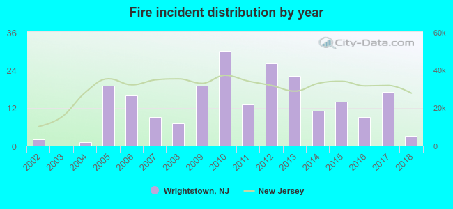 Based on the data from the years 2002 - 2018 the average number of fires per year is 13. The highest number of fire incidents - 30 took place in 2010, and the least - 0 in 2003. The data has a growing trend.
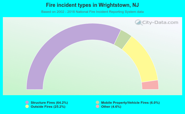 When looking into fire subcategories, the most incidents belonged to: Structure Fires (64.2%), and Outside Fires (25.2%).
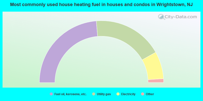
- 48.3%Fuel oil, kerosene, etc.
- 37.1%Utility gas
- 14.6%Electricity
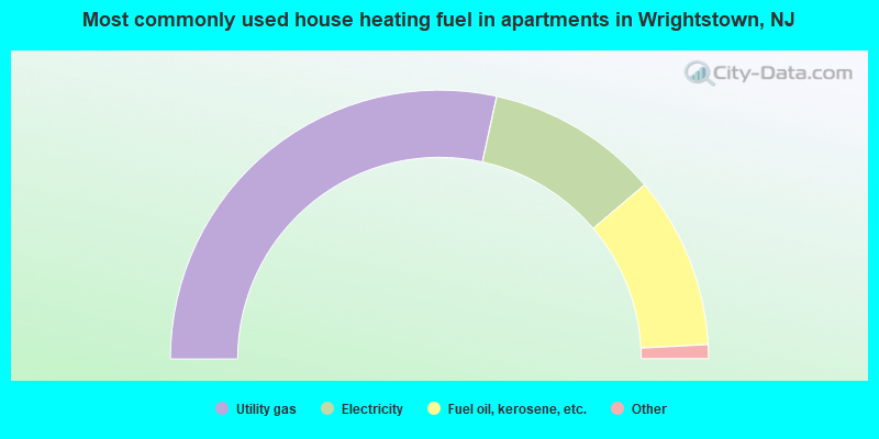
- 57.8%Utility gas
- 21.1%Electricity
- 21.1%Fuel oil, kerosene, etc.
Wrightstown compared to New Jersey state average:
- Median household income below state average.
- Median house value below state average.
- Unemployed percentage below state average.
- Black race population percentage above state average.
- Hispanic race population percentage below state average.
- Median age significantly below state average.
- Foreign-born population percentage significantly below state average.
- Renting percentage above state average.
- Length of stay since moving in significantly below state average.
- Percentage of population with a bachelor's degree or higher below state average.
Wrightstown on our top lists:
- #40 on the list of "Top 101 cities with the most residents born in Other Northern Africa (population 500+)"
- #75 on the list of "Top 101 cities with the most residents born in Pakistan (population 500+)"
- #43 on the list of "Top 101 counties with the highest average weight of females"
- #46 on the list of "Top 101 counties with the lowest percentage of residents that keep firearms around their homes"
- #50 on the list of "Top 101 counties with the highest percentage of residents that visited a dentist within the past year"
- #68 on the list of "Top 101 counties with the lowest number of infant deaths per 1000 residents 2007-2013 (pop. 50,000+)"
- #77 on the list of "Top 101 counties with the highest ground withdrawal of fresh water for public supply (pop. 50,000+)"

|
Total of 1 patent application in 2008-2024.