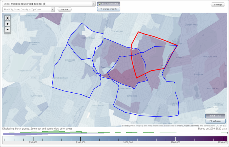
Bronxville, New York Neighborhood Map - Income, House Prices, Occupations, Boundaries
Settings
X

- City boundary
- Neighborhood boundaries
Business Search - 14 Million verified businesses
Neighborhoods:
Cedar Knolls, Chester Heights, Lawrence Park West, Village of BronxvilleCedar Knolls neighborhood in Bronxville statistics: (Find on map)
Area: 0.438 square miles
Population: 5,280
Population density:
Median household income in 2021:
Median rent in in 2021:
Male vs Females
Median age
Housing prices:
Average estimated value of detached houses in 2021 (55.4% of all units):
Average estimated value of townhouses or other attached units in 2021 (2.2% of all units):
Average estimated value of housing units in 2-unit structures in 2021 (2.1% of all units):
Average estimated '21 value of housing units in 5-or-more-unit structures (22.4% of all units):
Most popular occupations of males: management occupations (except farmers) (23.9%); education, training, and library occupations (16.9%); sales and office occupations (16.4%); service occupations (6.7%); computer and mathematical occupations (6.4%); business and financial operations occupations (6.3%); legal occupations (6.1%)
Most popular occupations of females: healthcare practitioners and technical occupations (23.3%); education, training, and library occupations (17.8%); sales and office occupations (17.3%); management occupations (except farmers) (12.5%); business and financial operations occupations (11.0%); service occupations (8.0%); arts, design, entertainment, sports, and media occupations (7.2%)
Highways in this neighborhood: State Hwy 100 (Central Park Ave).
Roads and streets: Bronx River Pkwy; Pondfield Rd W; Bronxville Rd; Parkview Ave; Birchbrook Rd; Ellison Ave; Dellwood Rd; Chatfield Rd; Tuckahoe Rd; Cassilis Ave; Gard Ave; Deshon Ave; Longvale Rd; Howe Pl; Perry Pl; Cedar Ln; Barrington Rd; Wiltshire St; Cross St; Beechmont Ave; Merriam Ave; Millard Ave; Palmer Rd (33); Dellwood Cir; Vera Rd; Garrett Pl; Beale Cir; Brooke Ave; Bayberry St; Wiltshire Pl; Lenox Ave; Merriam Pl; Smith Pl; Wilbur Pl; Miller Pl; Cranston Pl; Witherall St; Adele Ln; Meadow Ave W; Brassie Ln; Clark Pl; Bogert Pl; St Nicholas Ave; Boyd Pl; Ellison Pl; Amsterdam Ave; Anita Rd; Bryn Mawr Pkwy; Betty Ln; Millison Close.
Other features: Grassy Sprain Brk; Bronx Riv.
Cedar Knolls neighborhood detailed profile
Area: 0.438 square miles
Population: 5,280
Population density:
| Cedar Knolls: | 12,042 people per square mile |
| Bronxville: | 6,897 people per square mile |
Median household income in 2021:
| Cedar Knolls: | $145,680 |
| Bronxville: | $168,917 |
Median rent in in 2021:
| Cedar Knolls: | $1,003 |
| Bronxville: | $2,001 |
Male vs Females
| Males: | 2,621 |
| Females: | 2,658 |
Median age
| Males: | 47.1 years |
| Females: | 53.6 years |
Housing prices:
Average estimated value of detached houses in 2021 (55.4% of all units):
| Cedar Knolls: | $801,844 |
| New York: | $441,759 |
Average estimated value of townhouses or other attached units in 2021 (2.2% of all units):
| This neighborhood: | $160,108 |
| New York: | $658,853 |
Average estimated value of housing units in 2-unit structures in 2021 (2.1% of all units):
| This neighborhood: | $349,600 |
| New York: | $655,904 |
Average estimated '21 value of housing units in 5-or-more-unit structures (22.4% of all units):
| Cedar Knolls: | $366,849 |
| New York: | $784,206 |
Most popular occupations of males: management occupations (except farmers) (23.9%); education, training, and library occupations (16.9%); sales and office occupations (16.4%); service occupations (6.7%); computer and mathematical occupations (6.4%); business and financial operations occupations (6.3%); legal occupations (6.1%)
Most popular occupations of females: healthcare practitioners and technical occupations (23.3%); education, training, and library occupations (17.8%); sales and office occupations (17.3%); management occupations (except farmers) (12.5%); business and financial operations occupations (11.0%); service occupations (8.0%); arts, design, entertainment, sports, and media occupations (7.2%)
Highways in this neighborhood: State Hwy 100 (Central Park Ave).
Roads and streets: Bronx River Pkwy; Pondfield Rd W; Bronxville Rd; Parkview Ave; Birchbrook Rd; Ellison Ave; Dellwood Rd; Chatfield Rd; Tuckahoe Rd; Cassilis Ave; Gard Ave; Deshon Ave; Longvale Rd; Howe Pl; Perry Pl; Cedar Ln; Barrington Rd; Wiltshire St; Cross St; Beechmont Ave; Merriam Ave; Millard Ave; Palmer Rd (33); Dellwood Cir; Vera Rd; Garrett Pl; Beale Cir; Brooke Ave; Bayberry St; Wiltshire Pl; Lenox Ave; Merriam Pl; Smith Pl; Wilbur Pl; Miller Pl; Cranston Pl; Witherall St; Adele Ln; Meadow Ave W; Brassie Ln; Clark Pl; Bogert Pl; St Nicholas Ave; Boyd Pl; Ellison Pl; Amsterdam Ave; Anita Rd; Bryn Mawr Pkwy; Betty Ln; Millison Close.
Other features: Grassy Sprain Brk; Bronx Riv.
Cedar Knolls neighborhood detailed profile
Chester Heights neighborhood in Bronxville statistics: (Find on map)
Area: 2.015 square miles
Population: 14,929
Population density:
Median household income in 2021:
Median rent in in 2021:
Male vs Females
Median age
Housing prices:
Average estimated value of detached houses in 2021 (74.2% of all units):
Average estimated value of townhouses or other attached units in 2021 (5.9% of all units):
Average estimated value of housing units in 2-unit structures in 2021 (9.5% of all units):
Average estimated '21 value of housing units in 5-or-more-unit structures (29.8% of all units):
Most popular occupations of males: management occupations (except farmers) (23.9%); sales and office occupations (17.3%); business and financial operations occupations (11.1%); healthcare practitioners and technical occupations (9.9%); service occupations (8.6%); legal occupations (6.2%); education, training, and library occupations (3.2%)
Most popular occupations of females: sales and office occupations (22.7%); management occupations (except farmers) (22.5%); education, training, and library occupations (20.4%); business and financial operations occupations (8.1%); healthcare practitioners and technical occupations (5.4%); service occupations (5.4%); arts, design, entertainment, sports, and media occupations (3.6%)
Limited-access highways (interstate or state) in this neighborhood: Cross County Pkwy (Cross County Mall); Hutchinson River Pkwy.
Highways in this neighborhood: State Hwy 22 (White Plains Rd); N Columbus Ave (State Hwy 22).
Roads and streets: California Rd; New Rochelle Rd; Pondfield Rd; North Rd; Hewitt Ave; Middle Rd; Central Pkwy; Northway; Hutchinson Blvd; Siwanoy Blvd; Midland Ave; Sturgis Rd; Locust Ln; Parkway S; Hillcrest Rd; Masterton Rd; Pelhamdale Ave; Parkview Dr; Woodland Ave; Elm Rock Rd; Sherman Ave; Overhill Rd; Lockwood Ave; Pershing Ave; Elmsmere Rd; Dusenberry Rd; Hathaway Rd; Stuyvesant Plz; Crawford St; Sheridan Ave; Eastchester Rd; Robbins Rd; Archer Dr; Brookfield Rd; Oregon Ave; Tanglewylde Ave; Columbia Pl; Crows Nest Rd; Lawrence Pl; Lispenard Ave; Oriole Ave (Oriole Rd); Archer Pl; Southfield Rd; Courseview Rd; Greenfield Ave; E Devonia Ave; Bonita Vista Rd (Bonita Vista Dr); Pennsylvania Ave; Burkewood Rd; Mayflower Ave; Homesdale Rd; Sunnybrae Pl; Parkway E; Sussex Ave; Studio Ln; Linden Ave; Hilltop Rd; Hemlock Rd; Willow Ave; Commonwealth Ave; Carwall Ave; Summit Ave; Maple Ave; Eastway; Pasadena Rd; Foothill Rd; Rittenhouse Rd; Westway; Hamilton Ave; Chestnut Ave; Edgewood Ln; Lawrence St; Fordal Rd; Vernon Pkwy; Alta Dr; Elm Ln; Central Dr; Westwood Ave; Village Ln; Labelle Rd; Palmer Ave; Delrey Dr; Rosedale Ave; Colonial Rd; Hawthorne Rd; Overman Pl; Robins Cres; Beechwood Rd; Devonia Ave E; Orchard Pl; Wickford Rd; John Alden Rd; Siwanoy Clubway; Arizona Pl; Southway; Hillside Rd; Askins Pl; Greystone Cir; Rockridge Rd; Oakledge Rd; Southeastway; Paddington Rd; Pasadena Pl; South Rd; Raynor Ave; The Byway; High Rd; Pine Ave; Central Ave; Forest Ln; Argyle Pl; Euclid Ave; Ridgecroft Rd; Paddington Cir; Eastfield Rd; Parkway Cir; Ridge St; Hubbard Cir; Atlas Pl; Birch Ave; Robbins Cres; Arden Ter; Grove Ln; Alta Pkwy; Wood End Ln; Palo Alto Pl (Palo Alto Dr); Edgehill Clse; Monterey Dr; Walnut Ave; Bonita Vista Rd; Charles Pl; Parkway Plz; Wyndmere Rd; Leggett Rd; Corwood Rd; Poplar Ave; Chester Pl; Allaire St; Franklin Pl; Forster Pkwy; Alameda Pl; Audubon Ave; Buffington Pl; Manor Rd; Whitestone Pl; Oak Ave; Denman Pl; Tamerton St; Allen Pl; Utah Pl; Lee Pl; Thomas Pl; Mortimer Pl; Woodland Ter; Alder Ln; Pine Ter; Valois Pl; Alexander Pl; Meredith Pl (Meredith Ave); Rosedale St; Aetna Pl; Northwest Way; Huntwood Pl; Nevada Pl; Nancy Pl; 4th St; Library Ln; Lucille Pl; Normandy Dr (Normandy Rd); Dusenberry Pl; Carolyn Pl; Crampton Rd; Maybrook Cir; Hussey Rd; Hawthorne Ter; Grissom Dr; Crown Cir; Ridge Croft Rd; Access To County Pkwy.
Other features: Hutchinson Riv; Twin Lake No 2; 907W.
Chester Heights neighborhood detailed profile
Area: 2.015 square miles
Population: 14,929
Population density:
| Chester Heights: | 7,410 people per square mile |
| Bronxville: | 6,897 people per square mile |
Median household income in 2021:
| Chester Heights: | $178,029 |
| Bronxville: | $168,917 |
Median rent in in 2021:
| Chester Heights: | $2,519 |
| Bronxville: | $2,001 |
Male vs Females
| Males: | 7,159 |
| Females: | 7,770 |
Median age
| Males: | 38.1 years |
| Females: | 37.3 years |
Housing prices:
Average estimated value of detached houses in 2021 (74.2% of all units):
| Chester Heights: | $957,901 |
| New York: | $441,759 |
Average estimated value of townhouses or other attached units in 2021 (5.9% of all units):
| This neighborhood: | $996,813 |
| New York: | $658,853 |
Average estimated value of housing units in 2-unit structures in 2021 (9.5% of all units):
| This neighborhood: | $311,374 |
| New York: | $655,904 |
Average estimated '21 value of housing units in 5-or-more-unit structures (29.8% of all units):
| Chester Heights: | $314,669 |
| New York: | $784,206 |
Most popular occupations of males: management occupations (except farmers) (23.9%); sales and office occupations (17.3%); business and financial operations occupations (11.1%); healthcare practitioners and technical occupations (9.9%); service occupations (8.6%); legal occupations (6.2%); education, training, and library occupations (3.2%)
Most popular occupations of females: sales and office occupations (22.7%); management occupations (except farmers) (22.5%); education, training, and library occupations (20.4%); business and financial operations occupations (8.1%); healthcare practitioners and technical occupations (5.4%); service occupations (5.4%); arts, design, entertainment, sports, and media occupations (3.6%)
Limited-access highways (interstate or state) in this neighborhood: Cross County Pkwy (Cross County Mall); Hutchinson River Pkwy.
Highways in this neighborhood: State Hwy 22 (White Plains Rd); N Columbus Ave (State Hwy 22).
Roads and streets: California Rd; New Rochelle Rd; Pondfield Rd; North Rd; Hewitt Ave; Middle Rd; Central Pkwy; Northway; Hutchinson Blvd; Siwanoy Blvd; Midland Ave; Sturgis Rd; Locust Ln; Parkway S; Hillcrest Rd; Masterton Rd; Pelhamdale Ave; Parkview Dr; Woodland Ave; Elm Rock Rd; Sherman Ave; Overhill Rd; Lockwood Ave; Pershing Ave; Elmsmere Rd; Dusenberry Rd; Hathaway Rd; Stuyvesant Plz; Crawford St; Sheridan Ave; Eastchester Rd; Robbins Rd; Archer Dr; Brookfield Rd; Oregon Ave; Tanglewylde Ave; Columbia Pl; Crows Nest Rd; Lawrence Pl; Lispenard Ave; Oriole Ave (Oriole Rd); Archer Pl; Southfield Rd; Courseview Rd; Greenfield Ave; E Devonia Ave; Bonita Vista Rd (Bonita Vista Dr); Pennsylvania Ave; Burkewood Rd; Mayflower Ave; Homesdale Rd; Sunnybrae Pl; Parkway E; Sussex Ave; Studio Ln; Linden Ave; Hilltop Rd; Hemlock Rd; Willow Ave; Commonwealth Ave; Carwall Ave; Summit Ave; Maple Ave; Eastway; Pasadena Rd; Foothill Rd; Rittenhouse Rd; Westway; Hamilton Ave; Chestnut Ave; Edgewood Ln; Lawrence St; Fordal Rd; Vernon Pkwy; Alta Dr; Elm Ln; Central Dr; Westwood Ave; Village Ln; Labelle Rd; Palmer Ave; Delrey Dr; Rosedale Ave; Colonial Rd; Hawthorne Rd; Overman Pl; Robins Cres; Beechwood Rd; Devonia Ave E; Orchard Pl; Wickford Rd; John Alden Rd; Siwanoy Clubway; Arizona Pl; Southway; Hillside Rd; Askins Pl; Greystone Cir; Rockridge Rd; Oakledge Rd; Southeastway; Paddington Rd; Pasadena Pl; South Rd; Raynor Ave; The Byway; High Rd; Pine Ave; Central Ave; Forest Ln; Argyle Pl; Euclid Ave; Ridgecroft Rd; Paddington Cir; Eastfield Rd; Parkway Cir; Ridge St; Hubbard Cir; Atlas Pl; Birch Ave; Robbins Cres; Arden Ter; Grove Ln; Alta Pkwy; Wood End Ln; Palo Alto Pl (Palo Alto Dr); Edgehill Clse; Monterey Dr; Walnut Ave; Bonita Vista Rd; Charles Pl; Parkway Plz; Wyndmere Rd; Leggett Rd; Corwood Rd; Poplar Ave; Chester Pl; Allaire St; Franklin Pl; Forster Pkwy; Alameda Pl; Audubon Ave; Buffington Pl; Manor Rd; Whitestone Pl; Oak Ave; Denman Pl; Tamerton St; Allen Pl; Utah Pl; Lee Pl; Thomas Pl; Mortimer Pl; Woodland Ter; Alder Ln; Pine Ter; Valois Pl; Alexander Pl; Meredith Pl (Meredith Ave); Rosedale St; Aetna Pl; Northwest Way; Huntwood Pl; Nevada Pl; Nancy Pl; 4th St; Library Ln; Lucille Pl; Normandy Dr (Normandy Rd); Dusenberry Pl; Carolyn Pl; Crampton Rd; Maybrook Cir; Hussey Rd; Hawthorne Ter; Grissom Dr; Crown Cir; Ridge Croft Rd; Access To County Pkwy.
Other features: Hutchinson Riv; Twin Lake No 2; 907W.
Chester Heights neighborhood detailed profile
Lawrence Park West neighborhood in Bronxville statistics: (Find on map)
Area: 0.872 square miles
Population: 8,972
Population density:
Median household income in 2021:
Median rent in in 2021:
Male vs Females
Median age
Housing prices:
Average estimated value of detached houses in 2021 (16.9% of all units):
Average estimated value of townhouses or other attached units in 2021 (13.3% of all units):
Average estimated value of housing units in 2-unit structures in 2021 (22.5% of all units):
Average estimated '21 value of housing units in 3-to-4-unit structures (7.1% of all units):
Average estimated '21 value of housing units in 5-or-more-unit structures (41.1% of all units):
Most popular occupations of males: management occupations (except farmers) (27.1%); service occupations (15.3%); sales and office occupations (12.3%); education, training, and library occupations (8.4%); arts, design, entertainment, sports, and media occupations (6.6%); construction, extraction, and maintenance occupations (4.5%); business and financial operations occupations (4.4%)
Most popular occupations of females: sales and office occupations (30.0%); education, training, and library occupations (17.1%); service occupations (14.5%); business and financial operations occupations (9.9%); management occupations (except farmers) (8.1%); healthcare practitioners and technical occupations (4.8%); arts, design, entertainment, sports, and media occupations (4.5%)
Limited-access highways (interstate or state) in this neighborhood: Bronx River Pkwy; Cross County Pkwy (Cross County Mall); Sprain Brook Pkwy.
Roads and streets: Midland Ave; Kimball Ave; Rockledge Rd; Boulder Trl; Hampshire Rd; Bronxville Rd; Palmer Rd (33); Devon Rd; Sunnybrook Rd; Central Park Ave; Wrexham Rd; Warwick Rd; Brookside Cir; Ardell Rd; Glen Washington Rd; Lawrence Park Ter; Langdon Ter; Hereford Rd; Desmond Ave; Marquand Ave; Nevada Pl; Durham Rd; Rossmore Ave; Wildway; Eton Rd; Carlton Rd; Wilgarth Rd; Meadway (Mead Way); Ledgewood Rd; Highland Cir; Rutland Rd; Louisiana Ave; Georgia Ave; McGeory Ave; Moore Rd; Woodruff Ave; Montana Ave; Slocum Ave; Dewey Ave; de Witt Ave; Noble Ave; Illinois Ave; Tunis Ave; Hampshire Cir; Essex Pl; Lawrence Park Cres; Allen Ave N; Brook Rd; Castle St; Wellyn Rd; Texas Ave; Oregon Ave; Kent Rd; Vincent Rd; Shaefer Ave; Bronxville Ln; Florida Ave; Hackett Ave; Sussex Pl; Rockledge Pl; Blair St; Aldrich St; Beecher Rd; Moreland St; Lawton Ln; Parkway Rd; Brook Ave; Oak Bend; Allen Ave; Return Bend; Meadway; Wellyn Close.
Railroad features: Metro-North Commuter RR.
Other features: Bronx Riv; Grassy Sprain Brk.
Lawrence Park West neighborhood detailed profile
Area: 0.872 square miles
Population: 8,972
Population density:
| Lawrence Park West (Lawrence Park): | 10,293 people per square mile |
| Bronxville: | 6,897 people per square mile |
Median household income in 2021:
| Lawrence Park West (Lawrence Park): | $105,456 |
| Bronxville: | $168,917 |
Median rent in in 2021:
| Lawrence Park West (Lawrence Park): | $1,535 |
| Bronxville: | $2,001 |
Male vs Females
| Males: | 3,601 |
| Females: | 5,370 |
Median age
| Males: | 40.0 years |
| Females: | 43.2 years |
Housing prices:
Average estimated value of detached houses in 2021 (16.9% of all units):
| Lawrence Park West (Lawrence Park): | $1,394,454 |
| New York: | $441,759 |
Average estimated value of townhouses or other attached units in 2021 (13.3% of all units):
| This neighborhood: | $208,481 |
| New York: | $658,853 |
Average estimated value of housing units in 2-unit structures in 2021 (22.5% of all units):
| This neighborhood: | $491,870 |
| New York: | $655,904 |
Average estimated '21 value of housing units in 3-to-4-unit structures (7.1% of all units):
| Lawrence Park West (Lawrence Park): | $587,037 |
| New York: | $804,940 |
Average estimated '21 value of housing units in 5-or-more-unit structures (41.1% of all units):
| Lawrence Park West (Lawrence Park): | $185,541 |
| New York: | $784,206 |
Most popular occupations of males: management occupations (except farmers) (27.1%); service occupations (15.3%); sales and office occupations (12.3%); education, training, and library occupations (8.4%); arts, design, entertainment, sports, and media occupations (6.6%); construction, extraction, and maintenance occupations (4.5%); business and financial operations occupations (4.4%)
Most popular occupations of females: sales and office occupations (30.0%); education, training, and library occupations (17.1%); service occupations (14.5%); business and financial operations occupations (9.9%); management occupations (except farmers) (8.1%); healthcare practitioners and technical occupations (4.8%); arts, design, entertainment, sports, and media occupations (4.5%)
Limited-access highways (interstate or state) in this neighborhood: Bronx River Pkwy; Cross County Pkwy (Cross County Mall); Sprain Brook Pkwy.
Roads and streets: Midland Ave; Kimball Ave; Rockledge Rd; Boulder Trl; Hampshire Rd; Bronxville Rd; Palmer Rd (33); Devon Rd; Sunnybrook Rd; Central Park Ave; Wrexham Rd; Warwick Rd; Brookside Cir; Ardell Rd; Glen Washington Rd; Lawrence Park Ter; Langdon Ter; Hereford Rd; Desmond Ave; Marquand Ave; Nevada Pl; Durham Rd; Rossmore Ave; Wildway; Eton Rd; Carlton Rd; Wilgarth Rd; Meadway (Mead Way); Ledgewood Rd; Highland Cir; Rutland Rd; Louisiana Ave; Georgia Ave; McGeory Ave; Moore Rd; Woodruff Ave; Montana Ave; Slocum Ave; Dewey Ave; de Witt Ave; Noble Ave; Illinois Ave; Tunis Ave; Hampshire Cir; Essex Pl; Lawrence Park Cres; Allen Ave N; Brook Rd; Castle St; Wellyn Rd; Texas Ave; Oregon Ave; Kent Rd; Vincent Rd; Shaefer Ave; Bronxville Ln; Florida Ave; Hackett Ave; Sussex Pl; Rockledge Pl; Blair St; Aldrich St; Beecher Rd; Moreland St; Lawton Ln; Parkway Rd; Brook Ave; Oak Bend; Allen Ave; Return Bend; Meadway; Wellyn Close.
Railroad features: Metro-North Commuter RR.
Other features: Bronx Riv; Grassy Sprain Brk.
Lawrence Park West neighborhood detailed profile
Village of Bronxville neighborhood in Bronxville statistics: (Find on map)
Area: 0.995 square miles
Population: 11,667
Population density:
Median household income in 2021:
Median rent in in 2021:
Male vs Females
Median age
Housing prices:
Average estimated value of detached houses in 2021 (37.6% of all units):
Average estimated value of townhouses or other attached units in 2021 (6.3% of all units):
Average estimated '21 value of housing units in 5-or-more-unit structures (23.4% of all units):
Most popular occupations of males: management occupations (except farmers) (22.9%); sales and office occupations (21.8%); business and financial operations occupations (8.2%); construction, extraction, and maintenance occupations (8.1%); computer and mathematical occupations (7.7%); legal occupations (7.6%); service occupations (7.1%)
Most popular occupations of females: sales and office occupations (24.4%); management occupations (except farmers) (19.3%); business and financial operations occupations (16.1%); service occupations (10.7%); arts, design, entertainment, sports, and media occupations (9.5%); education, training, and library occupations (6.3%); healthcare practitioners and technical occupations (5.4%)
Highways in this neighborhood: State Hwy 22 (White Plains Rd).
Roads and streets: Pondfield Rd; Midland Ave; Tanglewylde Ave; Park Ave; Valley Rd; Avon Rd; Prescott Ave; Masterton Rd; Woodland Ave; Kensington Rd; Summit Ave; Elm Rock Rd; Kraft Ave; Sagamore Rd; Sturgis Rd; Dusenberry Rd; Meadow Ave; Crows Nest Rd; Oriole Ave (Oriole Rd); Courseview Rd; Concordia Pl; Greenfield Ave; Locust Ln; Garden Ave; Edgewood Ln; Paxton Ave; North Rd; Homesdale Rd; Sunnybrae Pl; Sussex Ave; Middle Rd; Studio Ln; Northway; Hemlock Rd; Parkway Rd; Pondfield Rd W; Hobart St; Palmer Ave; Fordal Rd; Elm Ln; Village Ln; Midland Gardens; Sycamore St; Hawthorne Rd; New Rochelle Rd; Beechwood Rd; Orchard Pl; Chestnut Ave; Rose Ave; Siwanoy Clubway; Westway; Plateau Cir W; Milburn St; Cedar St; Plateau Cir E; Paddington Rd; South Rd; Sunset Ave; The Byway; Hamilton Ave; de Witt Ave; Station Plz; High Rd; Stone Pl; Willow Rd; Governors Rd; Forest Ln; Argyle Pl; Ridgecroft Rd; Sherman Ave; Vine St; Depot Plz; Paddington Cir; Paradise Ave (Paradise Rd); Southgate; Grove Ln; Wood End Ln; Edgehill Clse; Eastway; Wellington Cir; Northern Ave; Park Pl; Lookout Ave; Oakledge Rd; Lake Ave; Gladwin Rd; Manor Rd; Red Oak Rd; Kensington Ter; Beechtree Ln; Beverly Gardens; Lee Pl; Alden Pl; Studio Arc; Alder Ln; Latimer Ln; Pine Ter; Northwest Way; Custer Pl; Bolton Gardens; Merestone Ter; Library Ln; Bolton Gdns; Gramatan Ave; Gramatan Ct; Oval Ct; Lassiter Ln; Normandy Rd (Normandy Dr); Dusenberry Pl; Crampton Rd; Gladwin Pl; Park Avenue Ter; Fulling Ave; Bacon Ct; Morningside Cir; Beverly Rd; Beverly Pl; Crown Cir; Ridge Croft Rd.
Railroad features: Metro-North Commuter RR.
Other features: Bronx Riv.
Village of Bronxville neighborhood detailed profile
Area: 0.995 square miles
Population: 11,667
Population density:
| Village of Bronxville (Bronxville Village): | 11,730 people per square mile |
| Bronxville: | 6,897 people per square mile |
Median household income in 2021:
| Village of Bronxville (Bronxville Village): | $174,557 |
| Bronxville: | $168,917 |
Median rent in in 2021:
| Village of Bronxville (Bronxville Village): | $3,067 |
| Bronxville: | $2,001 |
Male vs Females
| Males: | 5,363 |
| Females: | 6,303 |
Median age
| Males: | 38.1 years |
| Females: | 44.2 years |
Housing prices:
Average estimated value of detached houses in 2021 (37.6% of all units):
| Village of Bronxville (Bronxville Village): | $1,297,025 |
| New York: | $441,759 |
Average estimated value of townhouses or other attached units in 2021 (6.3% of all units):
| This neighborhood: | $1,011,273 |
| New York: | $658,853 |
Average estimated '21 value of housing units in 5-or-more-unit structures (23.4% of all units):
| Village of Bronxville (Bronxville Village): | $790,179 |
| New York: | $784,206 |
Most popular occupations of males: management occupations (except farmers) (22.9%); sales and office occupations (21.8%); business and financial operations occupations (8.2%); construction, extraction, and maintenance occupations (8.1%); computer and mathematical occupations (7.7%); legal occupations (7.6%); service occupations (7.1%)
Most popular occupations of females: sales and office occupations (24.4%); management occupations (except farmers) (19.3%); business and financial operations occupations (16.1%); service occupations (10.7%); arts, design, entertainment, sports, and media occupations (9.5%); education, training, and library occupations (6.3%); healthcare practitioners and technical occupations (5.4%)
Highways in this neighborhood: State Hwy 22 (White Plains Rd).
Roads and streets: Pondfield Rd; Midland Ave; Tanglewylde Ave; Park Ave; Valley Rd; Avon Rd; Prescott Ave; Masterton Rd; Woodland Ave; Kensington Rd; Summit Ave; Elm Rock Rd; Kraft Ave; Sagamore Rd; Sturgis Rd; Dusenberry Rd; Meadow Ave; Crows Nest Rd; Oriole Ave (Oriole Rd); Courseview Rd; Concordia Pl; Greenfield Ave; Locust Ln; Garden Ave; Edgewood Ln; Paxton Ave; North Rd; Homesdale Rd; Sunnybrae Pl; Sussex Ave; Middle Rd; Studio Ln; Northway; Hemlock Rd; Parkway Rd; Pondfield Rd W; Hobart St; Palmer Ave; Fordal Rd; Elm Ln; Village Ln; Midland Gardens; Sycamore St; Hawthorne Rd; New Rochelle Rd; Beechwood Rd; Orchard Pl; Chestnut Ave; Rose Ave; Siwanoy Clubway; Westway; Plateau Cir W; Milburn St; Cedar St; Plateau Cir E; Paddington Rd; South Rd; Sunset Ave; The Byway; Hamilton Ave; de Witt Ave; Station Plz; High Rd; Stone Pl; Willow Rd; Governors Rd; Forest Ln; Argyle Pl; Ridgecroft Rd; Sherman Ave; Vine St; Depot Plz; Paddington Cir; Paradise Ave (Paradise Rd); Southgate; Grove Ln; Wood End Ln; Edgehill Clse; Eastway; Wellington Cir; Northern Ave; Park Pl; Lookout Ave; Oakledge Rd; Lake Ave; Gladwin Rd; Manor Rd; Red Oak Rd; Kensington Ter; Beechtree Ln; Beverly Gardens; Lee Pl; Alden Pl; Studio Arc; Alder Ln; Latimer Ln; Pine Ter; Northwest Way; Custer Pl; Bolton Gardens; Merestone Ter; Library Ln; Bolton Gdns; Gramatan Ave; Gramatan Ct; Oval Ct; Lassiter Ln; Normandy Rd (Normandy Dr); Dusenberry Pl; Crampton Rd; Gladwin Pl; Park Avenue Ter; Fulling Ave; Bacon Ct; Morningside Cir; Beverly Rd; Beverly Pl; Crown Cir; Ridge Croft Rd.
Railroad features: Metro-North Commuter RR.
Other features: Bronx Riv.
Village of Bronxville neighborhood detailed profile