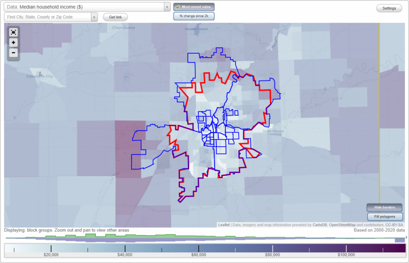
Fort Wayne, Indiana Neighborhood Map - Income, House Prices, Occupations, Boundaries
Settings
X

- City boundary
- Neighborhood boundaries
Business Search - 14 Million verified businesses
Neighborhoods:
Bloomingdale, Brentwood Park, Broad River, Creighton-Home, Downtown Fort Wayne, East Central, East Side, Fairfield, Five Points, Frances Slocum, Greater McMillen Park, Hamilton, Hanna Creighton, Harvester, Hoagland Masterson, LaRez, Lincoln Park, Memorial Park, Michigan Avenue, Nebraska, North Anthony, North Side, Northeast Fort Wayne, Northwest Fort Wayne, Oakdale, Oxford, Pettit Rudisill, Poplar, South Wayne, Southeast Fort Wayne, Southwest Fort Wayne, Spy Run, West Central, Williams - Woodland Park, Williams ParkBloomingdale neighborhood in Fort Wayne statistics: (Find on map)
Area: 0.576 square miles
Population: 3,443
Population density:
Median household income in 2021:
Median rent in in 2021:
Male vs Females
Median age
Housing prices:
Average estimated value of detached houses in 2021 (74.6% of all units):
Average estimated '21 value of housing units in 5-or-more-unit structures (2.1% of all units):
Most popular occupations of males: service occupations (23.0%); production occupations (17.6%); material moving occupations (9.5%); sales and office occupations (9.4%); transportation occupations (9.4%); management occupations (except farmers) (8.0%); construction, extraction, and maintenance occupations (4.9%)
Most popular occupations of females: service occupations (27.3%); sales and office occupations (19.4%); production occupations (17.5%); education, training, and library occupations (15.3%); material moving occupations (6.2%); healthcare practitioners and technical occupations (4.4%); community and social services occupations (2.9%)
Roads and streets: N Wells St; 3rd St; W 4th St; Cass St; Putnam St; 5th St; Barthold St; Andrew St; N Harrison St; Huffman St; Archer Ave; Spring St; Short St; Greenlawn Ave; High St; Florence Ave; 2nd St; Meridian St; Hensch St; Cortland Ave; W Jacobs Ave; 6th St; N Calhoun St; Fairmount Pl; Commerce Dr; Orchard St; Marion St; Kelly Dr; Geller St; Wells St; Wefel St; Clark St; 1st St; Beach St; E 4th St; Ewing St; Miller Ln; Marion Ct.
Railroad features: New York Chicago and St Louis RR; Penn Central RR.
Other features: St Marys Riv.
Bloomingdale neighborhood detailed profile
Area: 0.576 square miles
Population: 3,443
Population density:
| Bloomingdale: | 5,974 people per square mile |
| Fort Wayne: | 3,341 people per square mile |
Median household income in 2021:
| Bloomingdale: | $32,104 |
| Fort Wayne: | $54,737 |
Median rent in in 2021:
| Bloomingdale: | $556 |
| Fort Wayne: | $686 |
Male vs Females
| Males: | 1,532 |
| Females: | 1,910 |
Median age
| Males: | 37.1 years |
| Females: | 29.5 years |
Housing prices:
Average estimated value of detached houses in 2021 (74.6% of all units):
| Bloomingdale: | $67,088 |
| Indiana: | $227,058 |
Average estimated '21 value of housing units in 5-or-more-unit structures (2.1% of all units):
| Bloomingdale: | $111,293 |
| Indiana: | $193,907 |
Most popular occupations of males: service occupations (23.0%); production occupations (17.6%); material moving occupations (9.5%); sales and office occupations (9.4%); transportation occupations (9.4%); management occupations (except farmers) (8.0%); construction, extraction, and maintenance occupations (4.9%)
Most popular occupations of females: service occupations (27.3%); sales and office occupations (19.4%); production occupations (17.5%); education, training, and library occupations (15.3%); material moving occupations (6.2%); healthcare practitioners and technical occupations (4.4%); community and social services occupations (2.9%)
Roads and streets: N Wells St; 3rd St; W 4th St; Cass St; Putnam St; 5th St; Barthold St; Andrew St; N Harrison St; Huffman St; Archer Ave; Spring St; Short St; Greenlawn Ave; High St; Florence Ave; 2nd St; Meridian St; Hensch St; Cortland Ave; W Jacobs Ave; 6th St; N Calhoun St; Fairmount Pl; Commerce Dr; Orchard St; Marion St; Kelly Dr; Geller St; Wells St; Wefel St; Clark St; 1st St; Beach St; E 4th St; Ewing St; Miller Ln; Marion Ct.
Railroad features: New York Chicago and St Louis RR; Penn Central RR.
Other features: St Marys Riv.
Bloomingdale neighborhood detailed profile
Brentwood Park neighborhood in Fort Wayne statistics: (Find on map)
Area: 0.167 square miles
Population: 1,272
Population density:
Median household income in 2021:
Median rent in in 2021:
Male vs Females
Median age
Average estimated value of detached houses in 2021 (69.0% of all units):
Most popular occupations of males: management occupations (except farmers) (31.3%); production occupations (19.2%); sales and office occupations (15.7%); transportation occupations (8.9%); construction, extraction, and maintenance occupations (8.0%); material moving occupations (5.1%); business and financial operations occupations (1.9%)
Most popular occupations of females: service occupations (49.6%); sales and office occupations (20.3%); production occupations (16.5%); material moving occupations (3.7%); education, training, and library occupations (2.9%); healthcare practitioners and technical occupations (2.9%); management occupations (except farmers) (2.4%)
Highways in this neighborhood: Coliseum Blvd N (State Rd 930, US Hwy 30, US Hwy 24).
Roads and streets: Sherborne Blvd; Farnsworth Dr; Hastings Rd; Stafford Dr; Belfast Dr; Bosworth Dr; Bolton Dr; Dover Dr; E State Blvd.
Brentwood Park neighborhood detailed profile
Area: 0.167 square miles
Population: 1,272
Population density:
| Brentwood Park: | 7,634 people per square mile |
| Fort Wayne: | 3,341 people per square mile |
Median household income in 2021:
| Brentwood Park: | $35,992 |
| Fort Wayne: | $54,737 |
Median rent in in 2021:
| Brentwood Park: | $603 |
| Fort Wayne: | $686 |
Male vs Females
| Males: | 520 |
| Females: | 752 |
Median age
| Males: | 35.0 years |
| Females: | 49.9 years |
Average estimated value of detached houses in 2021 (69.0% of all units):
| Brentwood Park: | $125,608 |
| Indiana: | $227,058 |
Most popular occupations of males: management occupations (except farmers) (31.3%); production occupations (19.2%); sales and office occupations (15.7%); transportation occupations (8.9%); construction, extraction, and maintenance occupations (8.0%); material moving occupations (5.1%); business and financial operations occupations (1.9%)
Most popular occupations of females: service occupations (49.6%); sales and office occupations (20.3%); production occupations (16.5%); material moving occupations (3.7%); education, training, and library occupations (2.9%); healthcare practitioners and technical occupations (2.9%); management occupations (except farmers) (2.4%)
Highways in this neighborhood: Coliseum Blvd N (State Rd 930, US Hwy 30, US Hwy 24).
Roads and streets: Sherborne Blvd; Farnsworth Dr; Hastings Rd; Stafford Dr; Belfast Dr; Bosworth Dr; Bolton Dr; Dover Dr; E State Blvd.
Brentwood Park neighborhood detailed profile
Broad River neighborhood in Fort Wayne statistics: (Find on map)
Area: 0.211 square miles
Population: 1,103
Population density:
Median household income in 2021:
Median rent in in 2021:
Male vs Females
Median age
Average estimated value of detached houses in 2021 (72.8% of all units):
Most popular occupations of males: material moving occupations (21.5%); construction, extraction, and maintenance occupations (19.7%); service occupations (11.4%); production occupations (10.7%); sales and office occupations (7.5%); education, training, and library occupations (7.4%); architecture and engineering occupations (5.3%)
Most popular occupations of females: service occupations (39.9%); sales and office occupations (17.6%); production occupations (13.4%); material moving occupations (7.4%); community and social services occupations (6.4%); construction, extraction, and maintenance occupations (6.0%); arts, design, entertainment, sports, and media occupations (5.6%)
Roads and streets: Broadway St; Park Ave; Thompson Ave; Maple Ave; Huestis Ave; Home Ave; W Wildwood Ave; Waldron Cir; Fay Dr; Beaver Ave; Dinnen Ave; W Packard Ave; Maple Pl; Broadway; Saint Marys Pkwy; Eva St; Wildmere Dr.
Broad River neighborhood detailed profile
Area: 0.211 square miles
Population: 1,103
Population density:
| Broad River: | 5,226 people per square mile |
| Fort Wayne: | 3,341 people per square mile |
Median household income in 2021:
| Broad River: | $39,082 |
| Fort Wayne: | $54,737 |
Median rent in in 2021:
| Broad River: | $586 |
| Fort Wayne: | $686 |
Male vs Females
| Males: | 663 |
| Females: | 439 |
Median age
| Males: | 36.8 years |
| Females: | 32.0 years |
Average estimated value of detached houses in 2021 (72.8% of all units):
| Broad River: | $63,764 |
| Indiana: | $227,058 |
Most popular occupations of males: material moving occupations (21.5%); construction, extraction, and maintenance occupations (19.7%); service occupations (11.4%); production occupations (10.7%); sales and office occupations (7.5%); education, training, and library occupations (7.4%); architecture and engineering occupations (5.3%)
Most popular occupations of females: service occupations (39.9%); sales and office occupations (17.6%); production occupations (13.4%); material moving occupations (7.4%); community and social services occupations (6.4%); construction, extraction, and maintenance occupations (6.0%); arts, design, entertainment, sports, and media occupations (5.6%)
Roads and streets: Broadway St; Park Ave; Thompson Ave; Maple Ave; Huestis Ave; Home Ave; W Wildwood Ave; Waldron Cir; Fay Dr; Beaver Ave; Dinnen Ave; W Packard Ave; Maple Pl; Broadway; Saint Marys Pkwy; Eva St; Wildmere Dr.
Broad River neighborhood detailed profile
Creighton-Home neighborhood in Fort Wayne statistics: (Find on map)
Area: 0.139 square miles
Population: 955
Population density:
Median household income in 2021:
Median rent in in 2021:
Male vs Females
Median age
Average estimated value of detached houses in 2021 (50.1% of all units):
Most popular occupations of males: sales and office occupations (25.5%); service occupations (23.6%); arts, design, entertainment, sports, and media occupations (12.0%); transportation occupations (11.1%); management occupations (except farmers) (7.6%); material moving occupations (5.5%); production occupations (2.5%)
Most popular occupations of females: sales and office occupations (45.3%); service occupations (19.5%); material moving occupations (18.5%); production occupations (10.8%); business and financial operations occupations (2.4%); healthcare practitioners and technical occupations (1.7%); arts, design, entertainment, sports, and media occupations (1.0%)
Roads and streets: Home Ave; Beechwood Dr; Fox Ave; S Wayne Ave; Fairfield Ave; Indiana Ave; Pierce Ave; Meyer Ave; Beechwood Cir; Grace Ave; Miner St; Huestis Ave; Guildford Ave; Belle Ave; Plymouth Ave.
Creighton-Home neighborhood detailed profile
Area: 0.139 square miles
Population: 955
Population density:
| Creighton-Home: | 6,861 people per square mile |
| Fort Wayne: | 3,341 people per square mile |
Median household income in 2021:
| Creighton-Home: | $44,099 |
| Fort Wayne: | $54,737 |
Median rent in in 2021:
| Creighton-Home: | $619 |
| Fort Wayne: | $686 |
Male vs Females
| Males: | 445 |
| Females: | 509 |
Median age
| Males: | 36.0 years |
| Females: | 33.2 years |
Average estimated value of detached houses in 2021 (50.1% of all units):
| Creighton-Home: | $124,783 |
| Indiana: | $227,058 |
Most popular occupations of males: sales and office occupations (25.5%); service occupations (23.6%); arts, design, entertainment, sports, and media occupations (12.0%); transportation occupations (11.1%); management occupations (except farmers) (7.6%); material moving occupations (5.5%); production occupations (2.5%)
Most popular occupations of females: sales and office occupations (45.3%); service occupations (19.5%); material moving occupations (18.5%); production occupations (10.8%); business and financial operations occupations (2.4%); healthcare practitioners and technical occupations (1.7%); arts, design, entertainment, sports, and media occupations (1.0%)
Roads and streets: Home Ave; Beechwood Dr; Fox Ave; S Wayne Ave; Fairfield Ave; Indiana Ave; Pierce Ave; Meyer Ave; Beechwood Cir; Grace Ave; Miner St; Huestis Ave; Guildford Ave; Belle Ave; Plymouth Ave.
Creighton-Home neighborhood detailed profile
Downtown Fort Wayne neighborhood in Fort Wayne statistics: (Find on map)
Area: 0.678 square miles
Population: 2,238
Population density:
Median household income in 2021:
Median rent in in 2021:
Male vs Females
Median age
Housing prices:
Average estimated value of detached houses in 2021 (16.1% of all units):
Average estimated '21 value of housing units in 5-or-more-unit structures (49.3% of all units):
Most popular occupations of males: sales and office occupations (19.4%); service occupations (12.3%); management occupations (except farmers) (10.7%); architecture and engineering occupations (9.5%); production occupations (9.3%); construction, extraction, and maintenance occupations (6.8%); legal occupations (4.9%)
Most popular occupations of females: service occupations (20.7%); management occupations (except farmers) (16.7%); sales and office occupations (14.2%); healthcare practitioners and technical occupations (14.1%); education, training, and library occupations (12.0%); business and financial operations occupations (10.5%); architecture and engineering occupations (3.3%)
Highways in this neighborhood: State Rd 1 (US Hwy 33, Lafayette St, US Hwy 27).
Roads and streets: S Calhoun St; S Clinton St; S Harrison St; W Main St; W Berry St; W Wayne St; E Berry St; E Wayne St; W Jefferson Blvd; S Barr St (Barr St); W Washington Blvd; Clay St; Ewing St; Webster St; E Brackenridge St; E Lewis St; E Douglas Ave; E Washington Blvd; E Jefferson Blvd; E Main St; Pearl St; S Barr St; Fulton St; E Superior St; Fairfield Ave; W Baker St; W Douglas Ave; W Brackenridge St; W Superior St; W Lewis St; Madison St; E Columbia St; Main St E; McClellan St; Broadway; Maiden Ln; Barr St S; W Columbia St; Three Rivers N; Railroad St; Clair Ave; Duck St; E Baker St; Three Rivers E; Harmony Ct; Van Buren St; Court St; Monroe St (S Monroe St); N Wells St (S Wells St); Wood Ave; Jackson St; Rose Maries Aly.
Railroad features: Norfolk and Western Rlwy; Penn Central RR.
Downtown Fort Wayne neighborhood detailed profile
Area: 0.678 square miles
Population: 2,238
Population density:
| Downtown Fort Wayne (Downtown): | 3,299 people per square mile |
| Fort Wayne: | 3,341 people per square mile |
Median household income in 2021:
| Downtown Fort Wayne (Downtown): | $37,837 |
| Fort Wayne: | $54,737 |
Median rent in in 2021:
| Downtown Fort Wayne (Downtown): | $580 |
| Fort Wayne: | $686 |
Male vs Females
| Males: | 1,488 |
| Females: | 749 |
Median age
| Males: | 33.6 years |
| Females: | 29.6 years |
Housing prices:
Average estimated value of detached houses in 2021 (16.1% of all units):
| Downtown Fort Wayne (Downtown): | $112,267 |
| Indiana: | $227,058 |
Average estimated '21 value of housing units in 5-or-more-unit structures (49.3% of all units):
| Downtown Fort Wayne (Downtown): | $410,504 |
| Indiana: | $193,907 |
Most popular occupations of males: sales and office occupations (19.4%); service occupations (12.3%); management occupations (except farmers) (10.7%); architecture and engineering occupations (9.5%); production occupations (9.3%); construction, extraction, and maintenance occupations (6.8%); legal occupations (4.9%)
Most popular occupations of females: service occupations (20.7%); management occupations (except farmers) (16.7%); sales and office occupations (14.2%); healthcare practitioners and technical occupations (14.1%); education, training, and library occupations (12.0%); business and financial operations occupations (10.5%); architecture and engineering occupations (3.3%)
Highways in this neighborhood: State Rd 1 (US Hwy 33, Lafayette St, US Hwy 27).
Roads and streets: S Calhoun St; S Clinton St; S Harrison St; W Main St; W Berry St; W Wayne St; E Berry St; E Wayne St; W Jefferson Blvd; S Barr St (Barr St); W Washington Blvd; Clay St; Ewing St; Webster St; E Brackenridge St; E Lewis St; E Douglas Ave; E Washington Blvd; E Jefferson Blvd; E Main St; Pearl St; S Barr St; Fulton St; E Superior St; Fairfield Ave; W Baker St; W Douglas Ave; W Brackenridge St; W Superior St; W Lewis St; Madison St; E Columbia St; Main St E; McClellan St; Broadway; Maiden Ln; Barr St S; W Columbia St; Three Rivers N; Railroad St; Clair Ave; Duck St; E Baker St; Three Rivers E; Harmony Ct; Van Buren St; Court St; Monroe St (S Monroe St); N Wells St (S Wells St); Wood Ave; Jackson St; Rose Maries Aly.
Railroad features: Norfolk and Western Rlwy; Penn Central RR.
Downtown Fort Wayne neighborhood detailed profile
East Central neighborhood in Fort Wayne statistics: (Find on map)
Area: 0.966 square miles
Population: 3,646
Population density:
Median household income in 2021:
Median rent in in 2021:
Male vs Females
Median age
Housing prices:
Average estimated value of detached houses in 2021 (24.9% of all units):
Average estimated '21 value of housing units in 5-or-more-unit structures (84.3% of all units):
Most popular occupations of males: service occupations (36.2%); management occupations (except farmers) (24.2%); production occupations (10.6%); sales and office occupations (8.0%); computer and mathematical occupations (6.6%); architecture and engineering occupations (4.1%); construction, extraction, and maintenance occupations (3.6%)
Most popular occupations of females: sales and office occupations (20.4%); service occupations (18.1%); education, training, and library occupations (17.2%); business and financial operations occupations (16.1%); healthcare practitioners and technical occupations (14.1%); legal occupations (4.2%); arts, design, entertainment, sports, and media occupations (4.2%)
Roads and streets: E Lewis St; E Wayne St; E Berry St; E Washington Blvd; Hayden St; Hugh St; Maumee Ave; Eliza St; Harmar St; Clay St; Hanna St (S Hanna St); Francis St; Monroe St (S Monroe St); E Jefferson Blvd; Madison St; Summit St; Winter St; Ohio St; Lillie St; Chute St; Liberty St; Mc Culloch St; Schick St; E Brackenridge St; Division St; Coombs St; S Anthony Exd (S Anthony Blvd); Gay St; Oak St; E Douglas Ave; E Columbia St; Hanover St; Alliger St; Walter St; Begue St; Herbert St; Canal St; Griffin St; University St; Lanternier St; Cedar St; Simons St; Cochran St; Howard St; Comparet St; King St; River Bend Ct; Three Rivers E; Tam St; E Main St; Columbia Ave.
Railroad features: Norfolk and Western Rlwy; Penn Central RR.
Other features: Maumee Riv.
East Central neighborhood detailed profile
Area: 0.966 square miles
Population: 3,646
Population density:
| East Central: | 3,773 people per square mile |
| Fort Wayne: | 3,341 people per square mile |
Median household income in 2021:
| East Central: | $35,397 |
| Fort Wayne: | $54,737 |
Median rent in in 2021:
| East Central: | $759 |
| Fort Wayne: | $686 |
Male vs Females
| Males: | 2,613 |
| Females: | 1,033 |
Median age
| Males: | 33.0 years |
| Females: | 33.5 years |
Housing prices:
Average estimated value of detached houses in 2021 (24.9% of all units):
| East Central: | $86,897 |
| Indiana: | $227,058 |
Average estimated '21 value of housing units in 5-or-more-unit structures (84.3% of all units):
| East Central: | $1,824,615 |
| Indiana: | $193,907 |
Most popular occupations of males: service occupations (36.2%); management occupations (except farmers) (24.2%); production occupations (10.6%); sales and office occupations (8.0%); computer and mathematical occupations (6.6%); architecture and engineering occupations (4.1%); construction, extraction, and maintenance occupations (3.6%)
Most popular occupations of females: sales and office occupations (20.4%); service occupations (18.1%); education, training, and library occupations (17.2%); business and financial operations occupations (16.1%); healthcare practitioners and technical occupations (14.1%); legal occupations (4.2%); arts, design, entertainment, sports, and media occupations (4.2%)
Roads and streets: E Lewis St; E Wayne St; E Berry St; E Washington Blvd; Hayden St; Hugh St; Maumee Ave; Eliza St; Harmar St; Clay St; Hanna St (S Hanna St); Francis St; Monroe St (S Monroe St); E Jefferson Blvd; Madison St; Summit St; Winter St; Ohio St; Lillie St; Chute St; Liberty St; Mc Culloch St; Schick St; E Brackenridge St; Division St; Coombs St; S Anthony Exd (S Anthony Blvd); Gay St; Oak St; E Douglas Ave; E Columbia St; Hanover St; Alliger St; Walter St; Begue St; Herbert St; Canal St; Griffin St; University St; Lanternier St; Cedar St; Simons St; Cochran St; Howard St; Comparet St; King St; River Bend Ct; Three Rivers E; Tam St; E Main St; Columbia Ave.
Railroad features: Norfolk and Western Rlwy; Penn Central RR.
Other features: Maumee Riv.
East Central neighborhood detailed profile
East Side neighborhood in Fort Wayne statistics: (Find on map)
Area: 0.527 square miles
Population: 1,413
Population density:
Median household income in 2021:
Median rent in in 2021:
Male vs Females
Median age
Average estimated value of detached houses in 2021 (37.8% of all units):
Most popular occupations of males: service occupations (28.1%); construction, extraction, and maintenance occupations (25.1%); production occupations (16.9%); sales and office occupations (13.7%); management occupations (except farmers) (7.7%); material moving occupations (7.6%); computer and mathematical occupations (4.4%)
Most popular occupations of females: service occupations (31.9%); sales and office occupations (23.6%); material moving occupations (11.3%); production occupations (8.3%); business and financial operations occupations (7.4%); healthcare practitioners and technical occupations (6.4%); education, training, and library occupations (5.4%)
Roads and streets: Wayne Trce; Chestnut St; Reynolds St; New Haven Ave; Schele Ave; Raymond St; Roy St; E Pontiac St; Mc Cormick Ave; Fenker Ave; Lumbard St; Summer St; Warren St; Slataper St; Edsall Ave; Pitt St; Julian St; Molitor St; Dubois St; Lee St; Lawrence St (Lawrence Ave); E Creighton Ave; St Andrews Ln; Alden Ave; Pioneer St; Bitler St; Harvester Ave (Harvester St); Raymond Ave; Felician St.
Railroad features: Penn Central RR.
East Side neighborhood detailed profile
Area: 0.527 square miles
Population: 1,413
Population density:
| East Side (Eastside): | 2,681 people per square mile |
| Fort Wayne: | 3,341 people per square mile |
Median household income in 2021:
| East Side (Eastside): | $27,541 |
| Fort Wayne: | $54,737 |
Median rent in in 2021:
| East Side (Eastside): | $686 |
| Fort Wayne: | $686 |
Male vs Females
| Males: | 543 |
| Females: | 869 |
Median age
| Males: | 26.2 years |
| Females: | 29.3 years |
Average estimated value of detached houses in 2021 (37.8% of all units):
| East Side (Eastside): | $70,339 |
| Indiana: | $227,058 |
Most popular occupations of males: service occupations (28.1%); construction, extraction, and maintenance occupations (25.1%); production occupations (16.9%); sales and office occupations (13.7%); management occupations (except farmers) (7.7%); material moving occupations (7.6%); computer and mathematical occupations (4.4%)
Most popular occupations of females: service occupations (31.9%); sales and office occupations (23.6%); material moving occupations (11.3%); production occupations (8.3%); business and financial operations occupations (7.4%); healthcare practitioners and technical occupations (6.4%); education, training, and library occupations (5.4%)
Roads and streets: Wayne Trce; Chestnut St; Reynolds St; New Haven Ave; Schele Ave; Raymond St; Roy St; E Pontiac St; Mc Cormick Ave; Fenker Ave; Lumbard St; Summer St; Warren St; Slataper St; Edsall Ave; Pitt St; Julian St; Molitor St; Dubois St; Lee St; Lawrence St (Lawrence Ave); E Creighton Ave; St Andrews Ln; Alden Ave; Pioneer St; Bitler St; Harvester Ave (Harvester St); Raymond Ave; Felician St.
Railroad features: Penn Central RR.
East Side neighborhood detailed profile
Fairfield neighborhood in Fort Wayne statistics: (Find on map)
Area: 0.186 square miles
Population: 1,594
Population density:
Median household income in 2021:
Median rent in in 2021:
Male vs Females
Median age
Average estimated value of detached houses in 2021 (87.0% of all units):
Most popular occupations of males: material moving occupations (28.6%); service occupations (19.8%); production occupations (16.3%); transportation occupations (11.6%); management occupations (except farmers) (10.8%); construction, extraction, and maintenance occupations (6.9%); sales and office occupations (3.4%)
Most popular occupations of females: service occupations (38.6%); sales and office occupations (37.7%); production occupations (7.7%); education, training, and library occupations (4.6%); transportation occupations (3.3%); healthcare practitioners and technical occupations (2.9%); management occupations (except farmers) (2.4%)
Roads and streets: W Packard Ave; S Calhoun St; S Harrison St; Hoagland Ave; Webster St; W Wildwood Ave; W Leith St; Killea Ave (Killea St); Kinsmoor Ave; Shawnee Dr; W Darrow Ave; Kinnaird Ave; la Jolla Ct; Bond Ave.
Fairfield neighborhood detailed profile
Area: 0.186 square miles
Population: 1,594
Population density:
| Fairfield: | 8,579 people per square mile |
| Fort Wayne: | 3,341 people per square mile |
Median household income in 2021:
| Fairfield: | $48,057 |
| Fort Wayne: | $54,737 |
Median rent in in 2021:
| Fairfield: | $698 |
| Fort Wayne: | $686 |
Male vs Females
| Males: | 752 |
| Females: | 841 |
Median age
| Males: | 34.6 years |
| Females: | 32.2 years |
Average estimated value of detached houses in 2021 (87.0% of all units):
| Fairfield: | $113,691 |
| Indiana: | $227,058 |
Most popular occupations of males: material moving occupations (28.6%); service occupations (19.8%); production occupations (16.3%); transportation occupations (11.6%); management occupations (except farmers) (10.8%); construction, extraction, and maintenance occupations (6.9%); sales and office occupations (3.4%)
Most popular occupations of females: service occupations (38.6%); sales and office occupations (37.7%); production occupations (7.7%); education, training, and library occupations (4.6%); transportation occupations (3.3%); healthcare practitioners and technical occupations (2.9%); management occupations (except farmers) (2.4%)
Roads and streets: W Packard Ave; S Calhoun St; S Harrison St; Hoagland Ave; Webster St; W Wildwood Ave; W Leith St; Killea Ave (Killea St); Kinsmoor Ave; Shawnee Dr; W Darrow Ave; Kinnaird Ave; la Jolla Ct; Bond Ave.
Fairfield neighborhood detailed profile
Five Points neighborhood in Fort Wayne statistics: (Find on map)
Area: 0.393 square miles
Population: 1,520
Population density:
Median household income in 2021:
Median rent in in 2021:
Male vs Females
Median age
Housing prices:
Average estimated value of detached houses in 2021 (90.1% of all units):
Average estimated '21 value of housing units in 5-or-more-unit structures (62.0% of all units):
Most popular occupations of males: material moving occupations (27.8%); production occupations (17.1%); service occupations (14.4%); sales and office occupations (10.7%); management occupations (except farmers) (8.0%); construction, extraction, and maintenance occupations (5.9%); business and financial operations occupations (5.1%)
Most popular occupations of females: sales and office occupations (37.7%); service occupations (17.2%); education, training, and library occupations (11.6%); production occupations (10.0%); material moving occupations (8.5%); arts, design, entertainment, sports, and media occupations (6.5%); healthcare practitioners and technical occupations (3.6%)
Roads and streets: Goshen Ave; Elmer Ave; Russell Ave; N Wells St; Lillian Ave; Mildred Ave; Irene Ave; W State Blvd; Cass St; Hensch St; Clayton Ave; Sherman Blvd; Cortland Ave; Wallywood Dr (Wallywood Ave); Sties Dr; Lincoln Ct.
Railroad features: Penn Central RR.
Other features: Spy Run Crk.
Five Points neighborhood detailed profile
Area: 0.393 square miles
Population: 1,520
Population density:
| Five Points: | 3,863 people per square mile |
| Fort Wayne: | 3,341 people per square mile |
Median household income in 2021:
| Five Points: | $44,964 |
| Fort Wayne: | $54,737 |
Median rent in in 2021:
| Five Points: | $743 |
| Fort Wayne: | $686 |
Male vs Females
| Males: | 693 |
| Females: | 827 |
Median age
| Males: | 35.9 years |
| Females: | 36.6 years |
Housing prices:
Average estimated value of detached houses in 2021 (90.1% of all units):
| Five Points: | $101,919 |
| Indiana: | $227,058 |
Average estimated '21 value of housing units in 5-or-more-unit structures (62.0% of all units):
| Five Points: | $33,106 |
| Indiana: | $193,907 |
Most popular occupations of males: material moving occupations (27.8%); production occupations (17.1%); service occupations (14.4%); sales and office occupations (10.7%); management occupations (except farmers) (8.0%); construction, extraction, and maintenance occupations (5.9%); business and financial operations occupations (5.1%)
Most popular occupations of females: sales and office occupations (37.7%); service occupations (17.2%); education, training, and library occupations (11.6%); production occupations (10.0%); material moving occupations (8.5%); arts, design, entertainment, sports, and media occupations (6.5%); healthcare practitioners and technical occupations (3.6%)
Roads and streets: Goshen Ave; Elmer Ave; Russell Ave; N Wells St; Lillian Ave; Mildred Ave; Irene Ave; W State Blvd; Cass St; Hensch St; Clayton Ave; Sherman Blvd; Cortland Ave; Wallywood Dr (Wallywood Ave); Sties Dr; Lincoln Ct.
Railroad features: Penn Central RR.
Other features: Spy Run Crk.
Five Points neighborhood detailed profile
Frances Slocum neighborhood in Fort Wayne statistics: (Find on map)
Area: 0.466 square miles
Population: 2,364
Population density:
Median household income in 2021:
Median rent in in 2021:
Male vs Females
Median age
Average estimated value of detached houses in 2021 (90.4% of all units):
Most popular occupations of males: sales and office occupations (23.1%); service occupations (20.4%); production occupations (9.6%); construction, extraction, and maintenance occupations (9.2%); management occupations (except farmers) (8.7%); material moving occupations (6.5%); education, training, and library occupations (5.4%)
Most popular occupations of females: sales and office occupations (19.4%); healthcare practitioners and technical occupations (17.0%); service occupations (16.4%); business and financial operations occupations (10.4%); education, training, and library occupations (10.4%); management occupations (except farmers) (7.7%); arts, design, entertainment, sports, and media occupations (4.8%)
Roads and streets: E State Blvd; Hobson Rd; Kenwood Ave; Charlotte Ave; Glenwood Ave; Curdes Ave; Dodge Ave; Leroy Ave; Lynn Ave; Carew St; Vance Ave; Rolston St; Clara Ave; Beacon St; Santa Rosa Dr; Hazelwood Ave; Hubertus Ave; Lawndale Dr; Woodward Ave; Oakgrove Ave; Robert St; Santa Lisa Ct; Varsity Ln.
Frances Slocum neighborhood detailed profile
Area: 0.466 square miles
Population: 2,364
Population density:
| Frances Slocum: | 5,076 people per square mile |
| Fort Wayne: | 3,341 people per square mile |
Median household income in 2021:
| Frances Slocum: | $41,207 |
| Fort Wayne: | $54,737 |
Median rent in in 2021:
| Frances Slocum: | $577 |
| Fort Wayne: | $686 |
Male vs Females
| Males: | 1,195 |
| Females: | 1,169 |
Median age
| Males: | 36.5 years |
| Females: | 47.0 years |
Average estimated value of detached houses in 2021 (90.4% of all units):
| Frances Slocum: | $124,121 |
| Indiana: | $227,058 |
Most popular occupations of males: sales and office occupations (23.1%); service occupations (20.4%); production occupations (9.6%); construction, extraction, and maintenance occupations (9.2%); management occupations (except farmers) (8.7%); material moving occupations (6.5%); education, training, and library occupations (5.4%)
Most popular occupations of females: sales and office occupations (19.4%); healthcare practitioners and technical occupations (17.0%); service occupations (16.4%); business and financial operations occupations (10.4%); education, training, and library occupations (10.4%); management occupations (except farmers) (7.7%); arts, design, entertainment, sports, and media occupations (4.8%)
Roads and streets: E State Blvd; Hobson Rd; Kenwood Ave; Charlotte Ave; Glenwood Ave; Curdes Ave; Dodge Ave; Leroy Ave; Lynn Ave; Carew St; Vance Ave; Rolston St; Clara Ave; Beacon St; Santa Rosa Dr; Hazelwood Ave; Hubertus Ave; Lawndale Dr; Woodward Ave; Oakgrove Ave; Robert St; Santa Lisa Ct; Varsity Ln.
Frances Slocum neighborhood detailed profile
Greater McMillen Park neighborhood in Fort Wayne statistics: (Find on map)
Area: 0.260 square miles
Population: 1,584
Population density:
Median household income in 2021:
Median rent in in 2021:
Male vs Females
Median age
Average estimated value of detached houses in 2021 (95.0% of all units):
Most popular occupations of males: service occupations (29.6%); sales and office occupations (29.6%); production occupations (21.4%); construction, extraction, and maintenance occupations (5.2%); architecture and engineering occupations (4.2%); management occupations (except farmers) (1.8%); transportation occupations (1.2%)
Most popular occupations of females: service occupations (41.6%); sales and office occupations (28.0%); production occupations (19.3%); management occupations (except farmers) (5.0%); material moving occupations (4.7%); arts, design, entertainment, sports, and media occupations (1.3%)
Roads and streets: Oxford St; Trentman Ave; Drexel Ave; Evans St; Manford St; Ormsby St; Adams St; Fruehauf Dr; Queen St; Turpie St; Wayne Trce; Mauldin Dr; Mc Kee St; McKee St; Radcliffe Dr; Larwill Ct; Knode Ct.
Greater McMillen Park neighborhood detailed profile
Area: 0.260 square miles
Population: 1,584
Population density:
| Greater McMillen Park: | 6,086 people per square mile |
| Fort Wayne: | 3,341 people per square mile |
Median household income in 2021:
| Greater McMillen Park: | $32,601 |
| Fort Wayne: | $54,737 |
Median rent in in 2021:
| Greater McMillen Park: | $634 |
| Fort Wayne: | $686 |
Male vs Females
| Males: | 748 |
| Females: | 836 |
Median age
| Males: | 19.0 years |
| Females: | 28.0 years |
Average estimated value of detached houses in 2021 (95.0% of all units):
| Greater McMillen Park: | $40,538 |
| Indiana: | $227,058 |
Most popular occupations of males: service occupations (29.6%); sales and office occupations (29.6%); production occupations (21.4%); construction, extraction, and maintenance occupations (5.2%); architecture and engineering occupations (4.2%); management occupations (except farmers) (1.8%); transportation occupations (1.2%)
Most popular occupations of females: service occupations (41.6%); sales and office occupations (28.0%); production occupations (19.3%); management occupations (except farmers) (5.0%); material moving occupations (4.7%); arts, design, entertainment, sports, and media occupations (1.3%)
Roads and streets: Oxford St; Trentman Ave; Drexel Ave; Evans St; Manford St; Ormsby St; Adams St; Fruehauf Dr; Queen St; Turpie St; Wayne Trce; Mauldin Dr; Mc Kee St; McKee St; Radcliffe Dr; Larwill Ct; Knode Ct.
Greater McMillen Park neighborhood detailed profile
Hamilton neighborhood in Fort Wayne statistics: (Find on map)
Area: 0.468 square miles
Population: 3,105
Population density:
Median household income in 2021:
Median rent in in 2021:
Male vs Females
Median age
Average estimated value of detached houses in 2021 (78.7% of all units):
Most popular occupations of males: sales and office occupations (24.6%); construction, extraction, and maintenance occupations (17.9%); service occupations (11.5%); material moving occupations (11.1%); production occupations (7.1%); management occupations (except farmers) (5.7%); business and financial operations occupations (3.8%)
Most popular occupations of females: service occupations (33.8%); sales and office occupations (30.0%); community and social services occupations (6.3%); production occupations (6.2%); management occupations (except farmers) (5.4%); education, training, and library occupations (5.1%); healthcare practitioners and technical occupations (4.5%)
Roads and streets: Sinclair St; 3rd St; W 4th St; Sherman Blvd; Oakland St; St Marys Ave; Franklin Ave; Tyler Ave; Steup Ave; Spring St; Greenlawn Ave; Putnam St; Huffman St; Archer Ave; Margaret Ave; Ida Ave; Huffman Blvd; Cherokee Rd; Emma Ave; Ellen Ave; Emerson Ave; Florence Ave; Schilling Ave; Runnion Ave; Rumsey Ave; Rosemont Dr; Burgess St; High St; Herman St; Frederick St.
Railroad features: New York Chicago and St Louis RR; Penn Central RR.
Other features: St Marys Riv.
Hamilton neighborhood detailed profile
Area: 0.468 square miles
Population: 3,105
Population density:
| Hamilton: | 6,637 people per square mile |
| Fort Wayne: | 3,341 people per square mile |
Median household income in 2021:
| Hamilton: | $45,186 |
| Fort Wayne: | $54,737 |
Median rent in in 2021:
| Hamilton: | $600 |
| Fort Wayne: | $686 |
Male vs Females
| Males: | 1,510 |
| Females: | 1,595 |
Median age
| Males: | 38.8 years |
| Females: | 37.4 years |
Average estimated value of detached houses in 2021 (78.7% of all units):
| Hamilton: | $79,672 |
| Indiana: | $227,058 |
Most popular occupations of males: sales and office occupations (24.6%); construction, extraction, and maintenance occupations (17.9%); service occupations (11.5%); material moving occupations (11.1%); production occupations (7.1%); management occupations (except farmers) (5.7%); business and financial operations occupations (3.8%)
Most popular occupations of females: service occupations (33.8%); sales and office occupations (30.0%); community and social services occupations (6.3%); production occupations (6.2%); management occupations (except farmers) (5.4%); education, training, and library occupations (5.1%); healthcare practitioners and technical occupations (4.5%)
Roads and streets: Sinclair St; 3rd St; W 4th St; Sherman Blvd; Oakland St; St Marys Ave; Franklin Ave; Tyler Ave; Steup Ave; Spring St; Greenlawn Ave; Putnam St; Huffman St; Archer Ave; Margaret Ave; Ida Ave; Huffman Blvd; Cherokee Rd; Emma Ave; Ellen Ave; Emerson Ave; Florence Ave; Schilling Ave; Runnion Ave; Rumsey Ave; Rosemont Dr; Burgess St; High St; Herman St; Frederick St.
Railroad features: New York Chicago and St Louis RR; Penn Central RR.
Other features: St Marys Riv.
Hamilton neighborhood detailed profile
Hanna Creighton neighborhood in Fort Wayne statistics: (Find on map)
Area: 0.493 square miles
Population: 3,655
Population density:
Median household income in 2021:
Median rent in in 2021:
Male vs Females
Median age
Average estimated value of detached houses in 2021 (50.4% of all units):
Most popular occupations of males: production occupations (33.9%); computer and mathematical occupations (17.1%); sales and office occupations (8.7%); service occupations (8.6%); healthcare practitioners and technical occupations (6.0%); management occupations (except farmers) (4.7%); construction, extraction, and maintenance occupations (3.7%)
Most popular occupations of females: production occupations (25.8%); service occupations (21.4%); sales and office occupations (19.8%); business and financial operations occupations (13.8%); management occupations (except farmers) (8.8%); material moving occupations (4.7%); healthcare practitioners and technical occupations (3.7%)
Roads and streets: E Creighton Ave; E Wallace St; Smith St; Greene St; Weisser Park Ave; Hurd St; Gay St; John St; Oaklawn Ct; S Anthony Exd (S Anthony Blvd); Milan St; Euclid Ave; Bowser Ave; Holton Ave; Buchanan St; Oliver St; Greentree Ct; Winter St; Lillie St; Emily St; Reed St; Diamond St; Antoinette St; E Pontiac St; Fisher St; Central Dr; E Woodbine Pl; Eden St; Lahmeyer St.
Hanna Creighton neighborhood detailed profile
Area: 0.493 square miles
Population: 3,655
Population density:
| Hanna Creighton (Hanna-Creighton): | 7,414 people per square mile |
| Fort Wayne: | 3,341 people per square mile |
Median household income in 2021:
| Hanna Creighton (Hanna-Creighton): | $20,107 |
| Fort Wayne: | $54,737 |
Median rent in in 2021:
| Hanna Creighton (Hanna-Creighton): | $590 |
| Fort Wayne: | $686 |
Male vs Females
| Males: | 1,629 |
| Females: | 2,025 |
Median age
| Males: | 16.3 years |
| Females: | 22.6 years |
Average estimated value of detached houses in 2021 (50.4% of all units):
| Hanna Creighton (Hanna-Creighton): | $82,822 |
| Indiana: | $227,058 |
Most popular occupations of males: production occupations (33.9%); computer and mathematical occupations (17.1%); sales and office occupations (8.7%); service occupations (8.6%); healthcare practitioners and technical occupations (6.0%); management occupations (except farmers) (4.7%); construction, extraction, and maintenance occupations (3.7%)
Most popular occupations of females: production occupations (25.8%); service occupations (21.4%); sales and office occupations (19.8%); business and financial operations occupations (13.8%); management occupations (except farmers) (8.8%); material moving occupations (4.7%); healthcare practitioners and technical occupations (3.7%)
Roads and streets: E Creighton Ave; E Wallace St; Smith St; Greene St; Weisser Park Ave; Hurd St; Gay St; John St; Oaklawn Ct; S Anthony Exd (S Anthony Blvd); Milan St; Euclid Ave; Bowser Ave; Holton Ave; Buchanan St; Oliver St; Greentree Ct; Winter St; Lillie St; Emily St; Reed St; Diamond St; Antoinette St; E Pontiac St; Fisher St; Central Dr; E Woodbine Pl; Eden St; Lahmeyer St.
Hanna Creighton neighborhood detailed profile
Harvester neighborhood in Fort Wayne statistics: (Find on map)
Area: 0.408 square miles
Population: 393
Population density:
Median household income in 2021:
Median rent in in 2021:
Male vs Females
Median age
Average estimated value of detached houses in 2021 (100.0% of all units):
Most popular occupations of males: service occupations (16.3%); production occupations (16.0%); construction, extraction, and maintenance occupations (14.1%); material moving occupations (11.5%); sales and office occupations (11.2%); community and social services occupations (7.9%); arts, design, entertainment, sports, and media occupations (6.5%)
Most popular occupations of females: sales and office occupations (57.5%); service occupations (17.3%); production occupations (14.4%); material moving occupations (7.9%); computer and mathematical occupations (2.9%)
Highways in this neighborhood: Coliseum Blvd S.
Roads and streets: New Haven Ave; Raymond Ave; Schele Ave; Mc Cormick Ave; Reynolds St; E Pontiac St; Redwood Ave; Birchwood Ave; Holly Ave; Fleetwood Ave; Felician St; Logan Ave; Rodgers Ave; Chestnut St; Harvester Ave (Harvester St); Shadybrook Dr; Perth St; Woodside Dr.
Harvester neighborhood detailed profile
Area: 0.408 square miles
Population: 393
Population density:
| Harvester: | 963 people per square mile |
| Fort Wayne: | 3,341 people per square mile |
Median household income in 2021:
| Harvester: | $34,988 |
| Fort Wayne: | $54,737 |
Median rent in in 2021:
| Harvester: | $532 |
| Fort Wayne: | $686 |
Male vs Females
| Males: | 262 |
| Females: | 131 |
Median age
| Males: | 33.6 years |
| Females: | 32.7 years |
Average estimated value of detached houses in 2021 (100.0% of all units):
| Harvester: | $42,868 |
| Indiana: | $227,058 |
Most popular occupations of males: service occupations (16.3%); production occupations (16.0%); construction, extraction, and maintenance occupations (14.1%); material moving occupations (11.5%); sales and office occupations (11.2%); community and social services occupations (7.9%); arts, design, entertainment, sports, and media occupations (6.5%)
Most popular occupations of females: sales and office occupations (57.5%); service occupations (17.3%); production occupations (14.4%); material moving occupations (7.9%); computer and mathematical occupations (2.9%)
Highways in this neighborhood: Coliseum Blvd S.
Roads and streets: New Haven Ave; Raymond Ave; Schele Ave; Mc Cormick Ave; Reynolds St; E Pontiac St; Redwood Ave; Birchwood Ave; Holly Ave; Fleetwood Ave; Felician St; Logan Ave; Rodgers Ave; Chestnut St; Harvester Ave (Harvester St); Shadybrook Dr; Perth St; Woodside Dr.
Harvester neighborhood detailed profile
Hoagland Masterson neighborhood in Fort Wayne statistics: (Find on map)
Area: 0.172 square miles
Population: 923
Population density:
Median household income in 2021:
Median rent in in 2021:
Male vs Females
Median age
Average estimated value of detached houses in 2021 (57.8% of all units):
Most popular occupations of males: material moving occupations (33.2%); service occupations (24.3%); production occupations (8.2%); construction, extraction, and maintenance occupations (7.6%); sales and office occupations (6.7%); farming, fishing, and forestry occupations (4.9%); business and financial operations occupations (4.3%)
Most popular occupations of females: service occupations (44.1%); production occupations (35.3%); sales and office occupations (13.9%); material moving occupations (5.9%); healthcare practitioners and technical occupations (3.1%); community and social services occupations (2.6%); transportation occupations (1.0%)
Roads and streets: S Harrison St; Hoagland Ave; W Williams St; S Calhoun St; Webster St; W Masterson Ave; W Creighton Ave; W Butler St; W Dewald St; Melita St; W Wallace St; Brandriff St; Prince St; Bass St; Cromwell Ct.
Hoagland Masterson neighborhood detailed profile
Area: 0.172 square miles
Population: 923
Population density:
| Hoagland Masterson: | 5,361 people per square mile |
| Fort Wayne: | 3,341 people per square mile |
Median household income in 2021:
| Hoagland Masterson: | $35,062 |
| Fort Wayne: | $54,737 |
Median rent in in 2021:
| Hoagland Masterson: | $505 |
| Fort Wayne: | $686 |
Male vs Females
| Males: | 442 |
| Females: | 481 |
Median age
| Males: | 30.8 years |
| Females: | 33.4 years |
Average estimated value of detached houses in 2021 (57.8% of all units):
| Hoagland Masterson: | $88,248 |
| Indiana: | $227,058 |
Most popular occupations of males: material moving occupations (33.2%); service occupations (24.3%); production occupations (8.2%); construction, extraction, and maintenance occupations (7.6%); sales and office occupations (6.7%); farming, fishing, and forestry occupations (4.9%); business and financial operations occupations (4.3%)
Most popular occupations of females: service occupations (44.1%); production occupations (35.3%); sales and office occupations (13.9%); material moving occupations (5.9%); healthcare practitioners and technical occupations (3.1%); community and social services occupations (2.6%); transportation occupations (1.0%)
Roads and streets: S Harrison St; Hoagland Ave; W Williams St; S Calhoun St; Webster St; W Masterson Ave; W Creighton Ave; W Butler St; W Dewald St; Melita St; W Wallace St; Brandriff St; Prince St; Bass St; Cromwell Ct.
Hoagland Masterson neighborhood detailed profile
LaRez neighborhood in Fort Wayne statistics: (Find on map)
Area: 0.367 square miles
Population: 2,010
Population density:
Median household income in 2021:
Median rent in in 2021:
Male vs Females
Median age
Average estimated value of detached houses in 2021 (55.9% of all units):
Most popular occupations of males: material moving occupations (41.2%); service occupations (25.9%); arts, design, entertainment, sports, and media occupations (11.6%); management occupations (except farmers) (11.0%); sales and office occupations (8.3%); production occupations (7.3%); construction, extraction, and maintenance occupations (6.3%)
Most popular occupations of females: service occupations (48.2%); production occupations (39.0%); sales and office occupations (12.9%); material moving occupations (11.4%); business and financial operations occupations (11.1%); healthcare practitioners and technical occupations (9.7%); management occupations (except farmers) (6.2%)
Highways in this neighborhood: State Rd 1 (Lafayette St, US Hwy 27, US Hwy 33).
Roads and streets: S Clinton St; Hanna St (S Hanna St); E Masterson Ave; E Creighton Ave; E Dewald St; E Wallace St; E Suttenfield St; Barr St; Warsaw St; E Pontiac St; Lasalle St; St Martins St; Buchanan St; E Taber St; E Woodland Ave; E Butler St; E Williams St; Murray St; S Monroe St; Clay St; Caroline St.
LaRez neighborhood detailed profile
Area: 0.367 square miles
Population: 2,010
Population density:
| LaRez: | 5,477 people per square mile |
| Fort Wayne: | 3,341 people per square mile |
Median household income in 2021:
| LaRez: | $31,750 |
| Fort Wayne: | $54,737 |
Median rent in in 2021:
| LaRez: | $506 |
| Fort Wayne: | $686 |
Male vs Females
| Males: | 916 |
| Females: | 1,093 |
Median age
| Males: | 24.9 years |
| Females: | 27.9 years |
Average estimated value of detached houses in 2021 (55.9% of all units):
| LaRez: | $74,338 |
| Indiana: | $227,058 |
Most popular occupations of males: material moving occupations (41.2%); service occupations (25.9%); arts, design, entertainment, sports, and media occupations (11.6%); management occupations (except farmers) (11.0%); sales and office occupations (8.3%); production occupations (7.3%); construction, extraction, and maintenance occupations (6.3%)
Most popular occupations of females: service occupations (48.2%); production occupations (39.0%); sales and office occupations (12.9%); material moving occupations (11.4%); business and financial operations occupations (11.1%); healthcare practitioners and technical occupations (9.7%); management occupations (except farmers) (6.2%)
Highways in this neighborhood: State Rd 1 (Lafayette St, US Hwy 27, US Hwy 33).
Roads and streets: S Clinton St; Hanna St (S Hanna St); E Masterson Ave; E Creighton Ave; E Dewald St; E Wallace St; E Suttenfield St; Barr St; Warsaw St; E Pontiac St; Lasalle St; St Martins St; Buchanan St; E Taber St; E Woodland Ave; E Butler St; E Williams St; Murray St; S Monroe St; Clay St; Caroline St.
LaRez neighborhood detailed profile
Lincoln Park neighborhood in Fort Wayne statistics: (Find on map)
Area: 0.319 square miles
Population: 554
Population density:
Median household income in 2021:
Median rent in in 2021:
Male vs Females
Median age
Average estimated value of detached houses in 2021 (68.1% of all units):
Most popular occupations of males: material moving occupations (64.4%); architecture and engineering occupations (10.4%); healthcare practitioners and technical occupations (10.4%); sales and office occupations (8.8%); arts, design, entertainment, sports, and media occupations (5.1%); community and social services occupations (1.8%)
Most popular occupations of females: production occupations (51.8%); service occupations (23.4%); management occupations (except farmers) (10.7%); community and social services occupations (7.0%); computer and mathematical occupations (6.4%); transportation occupations (6.2%); legal occupations (4.7%)
Roads and streets: W State Blvd; N Highlands Blvd; Irene Ave; Stanford Ave; Poinsette Dr; Clayton Ave; Cambridge Blvd; Trinity Blvd; Princeton Ave; Purdue Dr; Tyler Ave; Ethel Ave; Yale Dr; Lillian Ave; Clifton Hills Dr; Goshen Ave; Sherman Blvd; St Marys Ave; Henry Ave; Betty Ave; Ralph Ave; Lawn Ave.
Lincoln Park neighborhood detailed profile
Area: 0.319 square miles
Population: 554
Population density:
| Lincoln Park: | 1,734 people per square mile |
| Fort Wayne: | 3,341 people per square mile |
Median household income in 2021:
| Lincoln Park: | $47,312 |
| Fort Wayne: | $54,737 |
Median rent in in 2021:
| Lincoln Park: | $619 |
| Fort Wayne: | $686 |
Male vs Females
| Males: | 195 |
| Females: | 358 |
Median age
| Males: | 40.7 years |
| Females: | 40.4 years |
Average estimated value of detached houses in 2021 (68.1% of all units):
| Lincoln Park: | $87,562 |
| Indiana: | $227,058 |
Most popular occupations of males: material moving occupations (64.4%); architecture and engineering occupations (10.4%); healthcare practitioners and technical occupations (10.4%); sales and office occupations (8.8%); arts, design, entertainment, sports, and media occupations (5.1%); community and social services occupations (1.8%)
Most popular occupations of females: production occupations (51.8%); service occupations (23.4%); management occupations (except farmers) (10.7%); community and social services occupations (7.0%); computer and mathematical occupations (6.4%); transportation occupations (6.2%); legal occupations (4.7%)
Roads and streets: W State Blvd; N Highlands Blvd; Irene Ave; Stanford Ave; Poinsette Dr; Clayton Ave; Cambridge Blvd; Trinity Blvd; Princeton Ave; Purdue Dr; Tyler Ave; Ethel Ave; Yale Dr; Lillian Ave; Clifton Hills Dr; Goshen Ave; Sherman Blvd; St Marys Ave; Henry Ave; Betty Ave; Ralph Ave; Lawn Ave.
Lincoln Park neighborhood detailed profile
Memorial Park neighborhood in Fort Wayne statistics: (Find on map)
Area: 0.525 square miles
Population: 899
Population density:
Median household income in 2021:
Median rent in in 2021:
Male vs Females
Median age
Average estimated value of detached houses in 2021 (64.1% of all units):
Most popular occupations of males: construction, extraction, and maintenance occupations (25.3%); service occupations (23.5%); sales and office occupations (13.2%); production occupations (11.5%); material moving occupations (10.6%); management occupations (except farmers) (5.4%); community and social services occupations (3.2%)
Most popular occupations of females: sales and office occupations (33.0%); service occupations (31.5%); material moving occupations (13.0%); education, training, and library occupations (6.8%); production occupations (5.8%); business and financial operations occupations (4.2%); healthcare practitioners and technical occupations (2.6%)
Roads and streets: E Washington Blvd; Maumee Ave; Pennsylvania St; Pittsburgh St; Winch St; Grant Ave; Mc Donald St; Wabash Ave; Jefferds Ave; Lumbard St; Roy St; Glasgow Ave; Edsall Ave; Kitch St; Fletcher Ave; Washington Blvd E; Sidney St; Dubois St; Summer St; Humphrey St; Hancock Ave; Warren St; Randall St; E Wayne St; Fairview Ave; White Ave; Luther St; Alliger St; Greenwalt Ave.
Railroad features: Norfolk and Western Rlwy.
Memorial Park neighborhood detailed profile
Area: 0.525 square miles
Population: 899
Population density:
| Memorial Park: | 1,712 people per square mile |
| Fort Wayne: | 3,341 people per square mile |
Median household income in 2021:
| Memorial Park: | $34,988 |
| Fort Wayne: | $54,737 |
Median rent in in 2021:
| Memorial Park: | $700 |
| Fort Wayne: | $686 |
Male vs Females
| Males: | 350 |
| Females: | 548 |
Median age
| Males: | 33.6 years |
| Females: | 32.7 years |
Average estimated value of detached houses in 2021 (64.1% of all units):
| Memorial Park: | $59,581 |
| Indiana: | $227,058 |
Most popular occupations of males: construction, extraction, and maintenance occupations (25.3%); service occupations (23.5%); sales and office occupations (13.2%); production occupations (11.5%); material moving occupations (10.6%); management occupations (except farmers) (5.4%); community and social services occupations (3.2%)
Most popular occupations of females: sales and office occupations (33.0%); service occupations (31.5%); material moving occupations (13.0%); education, training, and library occupations (6.8%); production occupations (5.8%); business and financial operations occupations (4.2%); healthcare practitioners and technical occupations (2.6%)
Roads and streets: E Washington Blvd; Maumee Ave; Pennsylvania St; Pittsburgh St; Winch St; Grant Ave; Mc Donald St; Wabash Ave; Jefferds Ave; Lumbard St; Roy St; Glasgow Ave; Edsall Ave; Kitch St; Fletcher Ave; Washington Blvd E; Sidney St; Dubois St; Summer St; Humphrey St; Hancock Ave; Warren St; Randall St; E Wayne St; Fairview Ave; White Ave; Luther St; Alliger St; Greenwalt Ave.
Railroad features: Norfolk and Western Rlwy.
Memorial Park neighborhood detailed profile
Michigan Avenue neighborhood in Fort Wayne statistics: (Find on map)
Area: 0.141 square miles
Population: 503
Population density:
Median household income in 2021:
Median rent in in 2021:
Male vs Females
Median age
Average estimated value of detached houses in 2021 (95.8% of all units):
Most popular occupations of males: construction, extraction, and maintenance occupations (46.5%); production occupations (11.4%); management occupations (except farmers) (10.5%); service occupations (9.1%); life, physical, and social science occupations (8.9%); material moving occupations (7.0%); sales and office occupations (6.3%)
Most popular occupations of females: service occupations (45.8%); construction, extraction, and maintenance occupations (22.3%); material moving occupations (10.0%); sales and office occupations (9.8%); computer and mathematical occupations (7.8%); production occupations (7.5%); community and social services occupations (5.8%)
Roads and streets: Guthrie St; Michigan Ave; Thompson Ave; Riedmiller Ave; Hale Ave; Zollars Ave; Nelson St; Leland St; Eagle St; Broadway; Brookside St.
Railroad features: Norfolk and Western Rlwy.
Michigan Avenue neighborhood detailed profile
Area: 0.141 square miles
Population: 503
Population density:
| Michigan Avenue: | 3,567 people per square mile |
| Fort Wayne: | 3,341 people per square mile |
Median household income in 2021:
| Michigan Avenue: | $41,475 |
| Fort Wayne: | $54,737 |
Median rent in in 2021:
| Michigan Avenue: | $797 |
| Fort Wayne: | $686 |
Male vs Females
| Males: | 274 |
| Females: | 228 |
Median age
| Males: | 42.3 years |
| Females: | 44.4 years |
Average estimated value of detached houses in 2021 (95.8% of all units):
| Michigan Avenue: | $66,542 |
| Indiana: | $227,058 |
Most popular occupations of males: construction, extraction, and maintenance occupations (46.5%); production occupations (11.4%); management occupations (except farmers) (10.5%); service occupations (9.1%); life, physical, and social science occupations (8.9%); material moving occupations (7.0%); sales and office occupations (6.3%)
Most popular occupations of females: service occupations (45.8%); construction, extraction, and maintenance occupations (22.3%); material moving occupations (10.0%); sales and office occupations (9.8%); computer and mathematical occupations (7.8%); production occupations (7.5%); community and social services occupations (5.8%)
Roads and streets: Guthrie St; Michigan Ave; Thompson Ave; Riedmiller Ave; Hale Ave; Zollars Ave; Nelson St; Leland St; Eagle St; Broadway; Brookside St.
Railroad features: Norfolk and Western Rlwy.
Michigan Avenue neighborhood detailed profile
Nebraska neighborhood in Fort Wayne statistics: (Find on map)
Area: 0.529 square miles
Population: 4,746
Population density:
Median household income in 2021:
Median rent in in 2021:
Male vs Females
Median age
Average estimated value of detached houses in 2021 (74.2% of all units):
Most popular occupations of males: production occupations (24.0%); service occupations (20.3%); sales and office occupations (18.5%); material moving occupations (11.7%); construction, extraction, and maintenance occupations (8.4%); business and financial operations occupations (2.5%); management occupations (except farmers) (1.9%)
Most popular occupations of females: service occupations (44.5%); sales and office occupations (29.3%); construction, extraction, and maintenance occupations (9.3%); production occupations (4.1%); healthcare practitioners and technical occupations (3.9%); computer and mathematical occupations (3.0%); arts, design, entertainment, sports, and media occupations (2.3%)
Roads and streets: High St; W Main St; Howell St; Osage St; Boone St; Runnion Ave; Polk St; Park Dr; Mechanic St; Richardson St; Burgess St; St Marys Ave; Center St; Wheeler St; Elm St; Growth Ave; Watkins St; Camp Allen Dr; Greenwood Ave; Degroff St; Franklin Ave; Davis St; Cherry St; Rumsey Ave; Mary St; Manufacturers Ave; Illinois St; Huron St; Breck St; Edgerton St; Fry St; Fair St; Morrison St; Link St; Bequette St; Perry Ave; Tyler Ave; Windom St; (Jefferson Blvd W).
Railroad features: Penn Central RR; Norfolk and Western Rlwy.
Other features: Junk Ditch.
Other features: St Marys Riv.
Nebraska neighborhood detailed profile
Area: 0.529 square miles
Population: 4,746
Population density:
| Nebraska: | 8,965 people per square mile |
| Fort Wayne: | 3,341 people per square mile |
Median household income in 2021:
| Nebraska: | $41,888 |
| Fort Wayne: | $54,737 |
Median rent in in 2021:
| Nebraska: | $568 |
| Fort Wayne: | $686 |
Male vs Females
| Males: | 2,478 |
| Females: | 2,268 |
Median age
| Males: | 32.6 years |
| Females: | 33.4 years |
Average estimated value of detached houses in 2021 (74.2% of all units):
| Nebraska: | $72,964 |
| Indiana: | $227,058 |
Most popular occupations of males: production occupations (24.0%); service occupations (20.3%); sales and office occupations (18.5%); material moving occupations (11.7%); construction, extraction, and maintenance occupations (8.4%); business and financial operations occupations (2.5%); management occupations (except farmers) (1.9%)
Most popular occupations of females: service occupations (44.5%); sales and office occupations (29.3%); construction, extraction, and maintenance occupations (9.3%); production occupations (4.1%); healthcare practitioners and technical occupations (3.9%); computer and mathematical occupations (3.0%); arts, design, entertainment, sports, and media occupations (2.3%)
Roads and streets: High St; W Main St; Howell St; Osage St; Boone St; Runnion Ave; Polk St; Park Dr; Mechanic St; Richardson St; Burgess St; St Marys Ave; Center St; Wheeler St; Elm St; Growth Ave; Watkins St; Camp Allen Dr; Greenwood Ave; Degroff St; Franklin Ave; Davis St; Cherry St; Rumsey Ave; Mary St; Manufacturers Ave; Illinois St; Huron St; Breck St; Edgerton St; Fry St; Fair St; Morrison St; Link St; Bequette St; Perry Ave; Tyler Ave; Windom St; (Jefferson Blvd W).
Railroad features: Penn Central RR; Norfolk and Western Rlwy.
Other features: Junk Ditch.
Other features: St Marys Riv.
Nebraska neighborhood detailed profile
North Anthony neighborhood in Fort Wayne statistics: (Find on map)
Area: 0.359 square miles
Population: 1,862
Population density:
Median household income in 2021:
Median rent in in 2021:
Male vs Females
Median age
Average estimated value of detached houses in 2021 (88.0% of all units):
Most popular occupations of males: service occupations (24.4%); sales and office occupations (14.9%); management occupations (except farmers) (14.8%); construction, extraction, and maintenance occupations (7.1%); healthcare practitioners and technical occupations (5.8%); production occupations (5.6%); transportation occupations (5.1%)
Most popular occupations of females: sales and office occupations (26.1%); healthcare practitioners and technical occupations (16.9%); service occupations (16.1%); education, training, and library occupations (10.2%); management occupations (except farmers) (9.9%); community and social services occupations (5.5%); business and financial operations occupations (4.5%)
Roads and streets: Kensington Blvd; N Anthony Blvd; Pemberton Dr; Randalia Dr; Curdes Ave; Lake Ave; Buena Vista Dr; Garfield St; Tilden Ave; Columbia Ave; Cody Ave; Forest Ave; Delaware Ave; Nevada Ave; Vermont Ave; Dodge Ave; Lynn Ave; E State Blvd; Glenwood Ave; Kenwood Ave; Lawndale Dr; Woodward Ave; Edgewater Ave; Charlotte Ave; Clara Ave; Niagara Dr.
Other features: Maumee Riv.
North Anthony neighborhood detailed profile
Area: 0.359 square miles
Population: 1,862
Population density:
| North Anthony: | 5,180 people per square mile |
| Fort Wayne: | 3,341 people per square mile |
Median household income in 2021:
| North Anthony: | $47,467 |
| Fort Wayne: | $54,737 |
Median rent in in 2021:
| North Anthony: | $677 |
| Fort Wayne: | $686 |
Male vs Females
| Males: | 952 |
| Females: | 909 |
Median age
| Males: | 35.1 years |
| Females: | 39.8 years |
Average estimated value of detached houses in 2021 (88.0% of all units):
| North Anthony: | $125,718 |
| Indiana: | $227,058 |
Most popular occupations of males: service occupations (24.4%); sales and office occupations (14.9%); management occupations (except farmers) (14.8%); construction, extraction, and maintenance occupations (7.1%); healthcare practitioners and technical occupations (5.8%); production occupations (5.6%); transportation occupations (5.1%)
Most popular occupations of females: sales and office occupations (26.1%); healthcare practitioners and technical occupations (16.9%); service occupations (16.1%); education, training, and library occupations (10.2%); management occupations (except farmers) (9.9%); community and social services occupations (5.5%); business and financial operations occupations (4.5%)
Roads and streets: Kensington Blvd; N Anthony Blvd; Pemberton Dr; Randalia Dr; Curdes Ave; Lake Ave; Buena Vista Dr; Garfield St; Tilden Ave; Columbia Ave; Cody Ave; Forest Ave; Delaware Ave; Nevada Ave; Vermont Ave; Dodge Ave; Lynn Ave; E State Blvd; Glenwood Ave; Kenwood Ave; Lawndale Dr; Woodward Ave; Edgewater Ave; Charlotte Ave; Clara Ave; Niagara Dr.
Other features: Maumee Riv.
North Anthony neighborhood detailed profile
North Side neighborhood in Fort Wayne statistics: (Find on map)
Area: 1.353 square miles
Population: 6,508
Population density:
Median household income in 2021:
Median rent in in 2021:
Male vs Females
Median age
Housing prices:
Average estimated value of detached houses in 2021 (75.7% of all units):
Average estimated '21 value of housing units in 5-or-more-unit structures (4.6% of all units):
Most popular occupations of males: service occupations (20.0%); transportation occupations (12.7%); sales and office occupations (11.9%); production occupations (10.7%); construction, extraction, and maintenance occupations (7.7%); management occupations (except farmers) (7.4%); material moving occupations (7.3%)
Most popular occupations of females: sales and office occupations (29.6%); service occupations (21.7%); healthcare practitioners and technical occupations (11.9%); production occupations (8.3%); management occupations (except farmers) (5.3%); business and financial operations occupations (5.0%); education, training, and library occupations (4.8%)
Roads and streets: Crescent Ave; Parnell Ave; E State Blvd; Kentucky Ave; Curdes Ave; Charlotte Ave; Kenwood Ave; St Joseph Blvd (St Joe Blvd); Edgewater Ave; Columbia Ave; Vance Ave; Lake Ave; Forest Ave; Northside Dr; California Ave; Florida Dr; Delaware Ave; River Forest Dr; Tecumseh St; Northlawn Ave (Northlawn Dr); Ferguson Ave; Glenwood Ave; Dodge Ave; Bayer Ave; Northwood Blvd; Tennessee Ave; Somerset Ln; Rivermet Ave; Oneida St; Alabama Ave; Pleasant Ave; Oswego Ave; Woodrow Ave; Vermont Ave; Nevada Ave; Lynn Ave; Saint Joe River Dr; Clara Ave; Hillside Ave; Stadium Dr; Elmwood Ave; Sallie Ave; Dearborn St; Eade Ave; Delta Blvd; Loree St; Fricke Ave; Glazier Ave; Romy Ave; Nettie Ave; Shore Dr; Addison Ave; Lafort St; Morton St; Tilden Ave; Emmett Ln; McDougal Ave; State Blvd E; Saint Joe Blvd; Hillcrest Dr.
Other features: St Joseph Riv; Maumee Riv.
North Side neighborhood detailed profile
Area: 1.353 square miles
Population: 6,508
Population density:
| North Side (Northside): | 4,811 people per square mile |
| Fort Wayne: | 3,341 people per square mile |
Median household income in 2021:
| North Side (Northside): | $47,032 |
| Fort Wayne: | $54,737 |
Median rent in in 2021:
| North Side (Northside): | $663 |
| Fort Wayne: | $686 |
Male vs Females
| Males: | 3,274 |
| Females: | 3,233 |
Median age
| Males: | 36.3 years |
| Females: | 32.8 years |
Housing prices:
Average estimated value of detached houses in 2021 (75.7% of all units):
| North Side (Northside): | $104,118 |
| Indiana: | $227,058 |
Average estimated '21 value of housing units in 5-or-more-unit structures (4.6% of all units):
| North Side (Northside): | $33,106 |
| Indiana: | $193,907 |
Most popular occupations of males: service occupations (20.0%); transportation occupations (12.7%); sales and office occupations (11.9%); production occupations (10.7%); construction, extraction, and maintenance occupations (7.7%); management occupations (except farmers) (7.4%); material moving occupations (7.3%)
Most popular occupations of females: sales and office occupations (29.6%); service occupations (21.7%); healthcare practitioners and technical occupations (11.9%); production occupations (8.3%); management occupations (except farmers) (5.3%); business and financial operations occupations (5.0%); education, training, and library occupations (4.8%)
Roads and streets: Crescent Ave; Parnell Ave; E State Blvd; Kentucky Ave; Curdes Ave; Charlotte Ave; Kenwood Ave; St Joseph Blvd (St Joe Blvd); Edgewater Ave; Columbia Ave; Vance Ave; Lake Ave; Forest Ave; Northside Dr; California Ave; Florida Dr; Delaware Ave; River Forest Dr; Tecumseh St; Northlawn Ave (Northlawn Dr); Ferguson Ave; Glenwood Ave; Dodge Ave; Bayer Ave; Northwood Blvd; Tennessee Ave; Somerset Ln; Rivermet Ave; Oneida St; Alabama Ave; Pleasant Ave; Oswego Ave; Woodrow Ave; Vermont Ave; Nevada Ave; Lynn Ave; Saint Joe River Dr; Clara Ave; Hillside Ave; Stadium Dr; Elmwood Ave; Sallie Ave; Dearborn St; Eade Ave; Delta Blvd; Loree St; Fricke Ave; Glazier Ave; Romy Ave; Nettie Ave; Shore Dr; Addison Ave; Lafort St; Morton St; Tilden Ave; Emmett Ln; McDougal Ave; State Blvd E; Saint Joe Blvd; Hillcrest Dr.
Other features: St Joseph Riv; Maumee Riv.
North Side neighborhood detailed profile
Northeast Fort Wayne neighborhood in Fort Wayne statistics: (Find on map)
Area: 25.377 square miles
Population: 61,514
Population density:
Median household income in 2021:
Median rent in in 2021:
Male vs Females
Median age
Housing prices:
Average estimated value of detached houses in 2021 (77.6% of all units):
Average estimated value of townhouses or other attached units in 2021 (5.6% of all units):
Average estimated '21 value of housing units in 5-or-more-unit structures (14.9% of all units):
Average estimated value of mobile home in 2021 (6.2% of all units):
Most popular occupations of males: sales and office occupations (18.8%); service occupations (13.4%); production occupations (13.1%); management occupations (except farmers) (10.6%); construction, extraction, and maintenance occupations (7.4%); transportation occupations (7.1%); material moving occupations (5.9%)
Most popular occupations of females: sales and office occupations (29.5%); service occupations (18.0%); healthcare practitioners and technical occupations (12.2%); management occupations (except farmers) (9.3%); education, training, and library occupations (7.6%); production occupations (5.9%); business and financial operations occupations (5.2%)
Highways in this neighborhood: State Rd 37 (Stellhorn Rd).
Roads and streets: E State Blvd; St Joe Center Rd; Maplecrest Rd; Trier Rd; Lake Ave; Vance Ave; Maysville Rd; Reed Rd; Crescent Ave; St Joe Rd; Coliseum Blvd E (930); Hobson Rd; Kenwood Ave; Charlotte Ave; Coliseum Blvd N (930); Dodge Ave; Curdes Ave; Forest Ave; N Anthony Blvd; Kensington Blvd; Inwood Dr; Lahmeyer Rd; Evard Rd; Wheelock Rd; Rothman Rd; Glenwood Ave; Nevada Ave; Columbia Ave; Delaware Ave; N River Rd; Lynn Ave; Monarch Dr; Carew St; Forest Park Blvd; Edgewater Ave; Parnell Ave; Kentucky Ave; Goeglein Rd; Beacon St; St Joseph Blvd (St Joe Blvd); Greyhawk Dr; Cherry Hill Pkwy; Clara Ave; Pemberton Dr; Saint Joe River Dr; Rolston St; Drakes Bay Run; Vermont Ave; Hartford Dr; Hazelwood Ave; Saint Joe Rd; W Arlington Park Blvd; Ashland Dr; Glencairn Dr; Woodway Dr; Sunny Ln; Salge Dr; Winnebago Dr; Rockwood Dr; Stonehedge Blvd; Northside Dr; California Ave; Canterbury Blvd; Litchfield Rd; Florida Dr; North Dr; Antebellum Blvd (Antebellum Dr); River Forest Dr; Lake Forest Village Cir; Highwood Dr; Oakhurst Dr; Londonderry Ln; Forest Valley Dr; Countess Dr; Tecumseh St; Ascher Dr; Leroy Ave; Woodlea Ave; Walden Run; Northlawn Ave (Northlawn Dr); Imperial Park Dr; Benham Dr; Abbey Dr; Northgate Blvd; Hazlett Rd; Bellefield Dr; Springfield Ave; Woodshire Dr; Birchdale Dr; Spanish Trl; Dalewood Dr; Tipperary Trl; Eicher Dr; Imperial Plaza Dr; Buckhurst Run; Berkley Ave; Tamarack Dr; Long Rd; Elmbrook Dr; Meijer Dr; Gate Tree Ln; Killeen Run; Sherborne Blvd; Wyandotte Dr; Welshire Blvd; Ferguson Ave; Tanbark Ln; Blum Dr; Stowaway Cove; Kern Valley Dr; Derome Dr; Ashbrook Dr; Kildore Xing; Delray Dr; Sawmill Woods Dr; Exeter Dr; Arlington Pkwy S; Twilight Ln; Kirkfield Dr; Treasure Cove; Thornbriar Ln; Christian Ave; Maple Terrace Pkwy; Fieldstone Ln; Parkerdale Dr; Frontier Ave; Bayer Ave; State Blvd E; Elwood Dr; Barnhart Ave; Nordholme Ave; White Oak Ave; Tilden Ave; Randalia Dr; Northwood Blvd; Buesching Dr; Santa Rosa Dr; Laverne Ave; Whitegate Dr; Derome Dr E; Allenwood Dr; Chancellor Dr; Regina Dr; Glenoak Pkwy; Innsbruck Dr; Sunland Dr; Hillsboro Ln; Fox Mill Run; Meadowbrook Dr; Country Park Ln (Oklahoma Trl); N Brookwood Dr; Becker St (Becker Dr); Maxim Dr; Tennessee Ave; Parker Dr; Manistee Dr; Bello Dr; Valley Meadows Dr; Millers Crossing Run; Turkey Run Dr; Revere Pl; Old Dover Blvd; Sunderland Dr; Pawawna Dr; Anthony Blvd N; Somerset Ln; Neighbor Dr; Rail Fence Rd; Landmark Dr; South Dr; Rivermet Ave; Blackhawk Ln; Oneida St; Lofton Way; Woodstock Dr (Woodstock Ave); Shell Dr; Schmucker Dr; Westminster Dr; Alabama Ave; Tunbridge Xing; Pleasant Ave; Oswego Ave; Midfield Dr; Woodrow Ave; Bradford Dr; Willowbrook Dr; Eastwick Dr; Hastings Rd; Danbury Ln; Farnsworth Dr; Autumn Woods Trl; Crofton Dr; Buena Vista Dr; Wyndemere Ln; Wrangler Trl; Placer Run; Amulet Dr; Winding Way Dr; Saint Joe Center Rd; Auer Dr; Ann Hackley Dr; Campus Dr W; Dennison Dr; Lawndale Dr; Courtwood Dr; Rosebury Dr; Fairlawn Pass; Newfield Dr; Lamont Dr; Bay View Dr; Kirkwood Dr; Stellhorn Crossing Blvd; Glenview Dr; Starwood Dr; Ivy Brook Dr; Duane Dr; Ivy League Dr (Ivy League Ln); Nadina Cv; Brian Dr; Knightway Dr; Haffner Dr; Albert Dr; Hampshire Dr; Potomac Dr; Quincy Ct; Marias Dr; Sagimore Ct; Pinehurst Dr; Shannon Dr; Rothermere Dr; Thornton Dr; Chantilly Dr; Plymouth Rd; Woodford Dr; Bolton Dr; Lake Forest Dr; Prestwick Run; Addison Ave; Goodfellow Dr; Greenwich Ct; Lawshe Dr; Vermont Ln; Maravilla Dr; Bell Tower Ln; Stanton Dr; Mirando Dr; Newland Pl; Clover Meadow Dr; Sea View Cove; Millhollow Ln; Chichester Ln; Stony Brook Dr; Kiwanis Dr; Ione Dr; Ferndale Dr; Valley Forge Pl; Roscommon Dr; Woodward Ave; Bitter End Cove; Nassau Dr; Linda Dr; Kirkdale Dr; Post Brook Ln; Lionel Dr; Bellwood Dr; Tewksbury Ct; Caribe Blvd; Monte Ave; Stafford Dr; Greendale Dr; Forest Grove Dr; Simcoe Dr (Simcoe Ct); Bradwood Ter; Brandonwood Ln; Beckstein Dr; Bojrab Dr; Thorngate Dr; Skipjack Cove; Trierwood Park Dr; Sandridge Rd; Granada Dr; Thamesford Dr; Woodmark Dr; Old Maysville Rd; Westlane Rd; Arnel Ave; Oakleaf Dr; Sandarac Ln; Hillside Ave; Doenges Dr; Karen Ave (Karen St); Eastwood Dr; Belfast Dr; Nighthawk Dr; Velmar Dr; Kerrigans Way; Diane Dr; Stadium Dr; Renfrew Dr; Centerton Dr; Lynhurst Dr; Scokian Dr; Skyhawk Dr; Glenridge Dr; Trotter Ct; Harmony Ln; Penrose Dr; Elmwood Ave; Roebuck Blvd; Laurel Hurst Pl; Fawncrest Pl; Monument Dr; Bennington Dr; Oak Park Dr; Ridgeside Ln; Bellingham Ln; Mill Ridge Run; Castell Dr; Andorra Dr; Cadet Dr; Cadena Ct (Cadena Ln); White Eagle Dr; Black Oak Blvd; Ramshire Ln; Hawksnest Trl; Victoria Dr; Sunnybrook Dr; Sallie Ave; Brackenwood Ct; Ray Dr; Harcourt Dr; Varsity Ln; Mapledowns Dr; Desoto Dr; Hewitt Ln; Mystic Dr; Knollcrest Rd; Cody Ave; Pine Meadows Ln; Hope Farm Rd; Chartercrest Dr; Springwood Dr; Wyoming Pass; Georgetown Ln; Port Royal; Running Brook Ln; Landover Pl; Shady Ln; Golden Ln; Crystal Ridge Cove; Dearborn St; Clubhouse Dr; Creekwood Trl; Midwood Dr; Providence Dr; Denise Dr; New England Dr; Cranston Ave; Groveland Dr; Ranger Trl; Countrydale Dr; Timberhill Dr; Greenfield Dr; Brookfield Dr; Wedgewood Dr; Park State Dr; Bosworth Dr; Garfield St; Oak Forest Trl; Old Brook Dr; Trotters Chase Ln; Cardinal Ln; Fountainhead Pl; Kreiselmeyer Dr; Georgetown North Blvd; Heatherwind Dr; Thoreau Ave; Dumont Dr; Mowhawa Dr; Durango Dr; Highgate Pl; Tanbark Trl; Eade Ave; Wheatridge Rd; Myanna Ln; Windsor Oaks Dr; Beaverbrook Dr; Duprey Dr; Arlington Pkwy N; Ottawa Dr; Martinique Rd; Foxcross Ct; Roanoke Dr; Cimarron Pass; Northwest Dr; Campus Dr S; Dial Dr; Laurelwood Cove; Brickshire Pkwy; Maple Valley Dr; Stellhorn Crossing Pkwy; Redstone Dr; Kristine Dr; St Croix Dr; Forest Downs Dr; Arrowwood Dr; Foxknoll Cove; Bristers Spring Run; Merivale St; Curwood Dr; Bent Willow Dr; Albany Ct; Keswick Ln; Chaucer Rd; Red Oak Dr; Hampstead Ln; Sweet Blossom Ct; Folsom Ln; Meriwood Dr; Bohde Trl; Crestfield Ct; Silverthorn Run; Midlothian Dr; Woodcrest Dr; Marston Dr; Delta Blvd; Bear Paw Dr; Northcreek Dr; Basel Dr; Lawford Ln; Carnoven Dr; Rupp Dr; Ballymore Dr; Wyndemere Pass; Kenaston Dr; Berlle Isle Ln; Camelot Dr; Wood Manor Run; Lawnwood Dr; Brockport Run; San Pedro Dr; David Ln; Rockingham Dr; Knightsbridge Pl; Southbrook Rd; Stillwood Dr; Countryview Dr; Repton Dr; Sugar Mill Dr; Saxton Run; Cordava Ct; Hedwig Dr; Graber Dr; Hubertus Ave; Karen Ct; Rosner Xing; Langwood Blvd; Loree St; Knollridge Dr; Manchester Dr; Shoaff Park River Dr; Upper St Joe Center Rd; Centerhurst Rd; Royal Dr; Bradenton Rd; Senior Dr; Dominion Dr; Porter Dr; Willshire Estates Dr; Fernbank Dr; Woodmark Ct; Windswept Dr; Brookshire Cir; Santa Fe Trl; Topsfield Ln; Kendale Dr; Willowhurst Dr; Bellmawr Ln; Brookview Dr; Ordway Dr; Greymoor Dr; Mauve Dr; Sunbury Dr; Sovereign Dr; Knightsbridge Dr; Captiva Dr; Fricke Ave; Glenhurst Ave; Woodrock Dr; Lakecrest Ct; Lake Valley Ct; Acorn Ln; N Arlington Park Blvd; Boca Trl; Fiesta Way; Connaught Ct; Chiswell Run; Sandhurst Dr; Pine Valley Dr; Langley Pass; Abington Dr; Bruneal Dr; Gold Dr; Philip Way; Joan Dr; Belvidere Dr; Bridlewood Dr; Putt Ln; Forest View Dr; Embers Ct; Madiera Dr; Evergreen Ln; Forest Wood Dr; Bayside Dr; Mathias St; Centerhurst Ter; Stanley Ave; Majestic Ln; Dover Dr; Dewberry Dr; Bahama Ln; Campus Dr E; Nantucket Dr; Darwood Dr; Forest Glen Ct; Trellis Cove; Woodcreek Ln; Encanto Way; Chickasaw Dr; Maysville Park Blvd; Chivington Dr; Piegan Pl; Kanata Ct; Brookline Ct; Roseview Rd; Sanibel Dr; Annette Ave; Linde Ln; Queensbury Dr; Marigold Dr; Hike Ln; Utah Dr; Oak Creek Ct; West Dr; Daner Dr; Coronet Dr; Thames Dr; Collegiate Ct; Lionsgate Run; Fieldstone Dr; Kingsbury Dr; Danbury Dr; Fall Brook Ln; Spring Burn Dr; Trishlyn Cove; East Dr; Vernandah Ln; Nottingham Dr; Wakopa Ct; Briar Bush Ln; Voors Dr; Brookfarm Pl; Ramblewood Dr; Morton St; Willman Ln; Glazier Ave; White Oak Dr; Woodstock Dr; Laurel Dr; Druid Hills Dr; Sandalwood Dr; Bluffside Ave; Kirkland Ave; Willshire Ct; 46th Dr; Georgetowne Park Dr; Finchley Ct; Lakehurst Dr; Hemlock Ln; 47th Dr; Connemarro Ct; Hadley Farm Ln; Tirol Pass; Romy Ave; Harrisburg Ln; Fountain Head Dr; Burrwood Ter; Mamie Dr; del Rio Dr; Casa Grande Dr; Bruick Ln; Pana Dr; Dwight Dr; Driftwood Dr; St Thomas Pt E; Scarlet Ct; Belle Isle Ln; Country Park Ln; Baychester Dr; River Bluff Dr; Busche Dr; Woodthrush Dr; Niagara Dr; Cathedral Oaks Pl; Jason Dr; Corby Dr; Emmons Dr; Willowwood Dr; Monique Dr; Taliesin Way; Belle Plain Cove; Nettie Ave; Wood Meadows Ln; Brixham Pl; Flagstone Dr; Old Grist Mill Pl; Hallowell Pl; Heritage Park Dr; Dyerbrook Pass; Broyles Blvd; W Shenandoah Cir; Shore Dr; Winnebago Ct; Forest Creek Pkwy; Margot Way; Nelwood Dr; Tranquilla Pl; Rebecca St; Kendawa Dr; Bluegrass Ln; Basswood Pl; Kirkwood Cir; Glenrose Dr; Nyack Ave; Maple Ridge Dr; Damask Dr; Raleigh Ct; Briarcliff Dr; Montana Dr (Montana Pass); Hunterdon Cove; Copper Creek Pl; Clovercrest Dr; Blueridge Ln; Furge Dr; Northhampton Pl; Sawmill Woods Blvd; Bob O Link Crossover; Nina Dr; E Shenandoah Cir; Kercheval Dr; Windlass Ct; Preakness Cove; Meadow Hills Dr; E Shore Dr; Collbran Ct; Tonawanda Dr; Elsdale Dr; Tralee Ct; Hawkeechee Dr; Crestview Dr; Willard Dr; Fitchburg Pl; Lombard Pl; Oak Creek Dr; Waterfront Dr; Aloha Dr; Jonquil Dr; Sweetwater Pl; Fortuna Way; Edinborough Ln; Canby Dr; Worchester Pl; Crestfield Ave; Bellshire Way; Fantasia Ln (Fantasia Way); Parliament Pl; Cutters Creek; Shepherd Ln; Kingsley Dr; Harold Dr; Clipper Cove; Sable Ct; Westwick Pl; Belle Isle Pl; Merrimack Pl; Beacon Ridge Pl; Idaho Ct (Idaho Dr); Castle Pines Pl; Squires Pl; New Burg Pl; Sedgewick Pl; Meridith Dr; Jonathon Oaks Blvd; Hermitage Pl; Muirfield Dr; Carlow Ct; Sedgemore Pl; Donegstor Pl; Red Clover Ln; Welsh Dr; Shadowbrook Cove; Devon Ct (Devon Dr); Cherrystone Ln; Inwood Ln; Chelmsford Pl; Stonehill Ct; Rio Vista Dr; E Arlington Park Blvd; Oak Mill Pl; Wyndemere Ct; Wishingwell Ct; Valley Dr; Cooper Pt Run; Muscoda Dr (Quail Canyon Dr); Terry Ln; Seafarer Cove; Lassiter Mill Pl; Ridgedale Dr; Sudbury Pl; Temberton Way; Pepperill Ridge; Blue Beech Dr; Plantation Ln; Bohnke Dr; Shackleford Rd; Silver Wolf Trl; Lucerne Xing; Kinlock Pl; Collbran Dr; Beechcrest Dr; Hillsboro Ct; Dune Creek Cove; Papago Ct; Glouchester Dr; Kerrway Ct; Mangrove Ln; Brook Dr; Twisted Oak Ct; Becky Ln; Vineland Dr; Red Dr; Tennyson Pl; Hubbard Run; Shade Creek Pl; Wakashan Pl; Ivy Point Pl; Arbor View Ct; Deerpointe Cove; Rollindale Dr; Derby Ln; Sterling Way Ct; Preston Dr; Fountainhead Dr; Hinsdale Ln; Mateo Ct; Firwood Dr; Heywood Cove; Martys Hill Pl; Sandyridge Pl; Bramblecrest Dr; Kingsland Ct; Lafort St; Ponema Ct; Pheasant Run; Star Pine Way; Woodbury Dr; Weston Ridge Pl; Colony Ct; Solitude Pl; Tristam Ct; Graysford Pl; Dutchess Ln; Asher Dr; East Xing; Naquaga Dr; Nature Trail Dr; Redstone Ct; Galaxy Dr; Corydon Ct; Wildberry Ln; Fontana Dr; Montcalm Ct; Palmilla Ct; Woodbriar Pass; Echo Ln; Kingston Pt; Creekwood Ln; Angello Ct; Grand Forest Ct; Pebble Creek Pl; Wolfsboro Ln; Fallingbrook Ln; Butterfield Dr; Tarrington Dr; Kennedy Dr; Araglin Pointe; Bandon Dr; Potowatami Dr; Greythorn Dr; Arborfield Ct; Hobson Dr; Timber Wheel Ct; Winslow Pl; Lynwood Ct; Darby Dr; Randford Pl; Landers Ct; Faulkner Ct; Westford Ct; Sawmill Woods Ct; Timbers End Pl; Miaqueah Ct; Barton Ln; Wind Ridge Ln; Montavilla Dr; Briar Rose Ct; Thornwood Ct; Daisy Ln; Weybridge Pl; Old Cove Pond; Lorman Ct; Donegal Dr; Whetstone Ln; Pleasant Run Ct; Robin Run; Orchard View Ct; Clarmarnic Dr; Lamplighter Ct; Scepter Ct; Garland Dr; Yardley Ct; Roxboro Ct; Tonawanda Ct; Valley View Dr; Gateway Ct; Maycrest Dr; Grandure Dr; Talmage Ct; Quailwest Cove; Guaine Ct; Lancelot Ct; Janet Dr; Bright Oaks Trl; Dawn Ave; Chapel Bend Dr; Deveraux Dr; Old Willow Pl; Langley Ct; Stepping Stone Ln; Lark Meadow Run; Shadow Lake Ln; Arch Tree Pl; Clingmans Trl; Canopy Ln; Hazelett Dr; Hidden Village Pl; Burlington Ave; Kennon Ct; Sheldon Dr; Cheshire Ct; Grayling Pl; Leeds Ln; Vida Dr; Kebir Ct; Lockwood Dr; Salge Dr (Salge Ct); Shag Bark Ct; Wayward Ct; Royal Oak Dr; Meadows Ct; Bonita Pl (Bonita Dr); Althean Dr; Brandy Chase Cove; Briarwood Ct; Pheasant Pass; Cross Ln; Roxton Ln; Justin Dr; Blackfoot Ct; Timberland Dr; Knollwood Ct; Louden Dr; Seabree Ln; Tiger Lily Pl; Oak Bridge Pl; Harwick Ct; Montgomery Ct; Brockton Ln; Truemper Way; Calico Ct; Rutland Ln; Graymoor Ln; Argonia Dr; Chicory Dr; Sir Francis Cove; Deville Pl; Wayoata Ct; Oakgrove Ave; Underwood Cove; Chateau Pl; Hunter Wood Dr; Mosskey Ct; Wrangler Ct; Omee Ct; Northlane Rd; Norward Ln; Canterwood Pl; Gallmeyer Ct; Rockcroft Ct; Creekwood Blvd; Talbot Ct; Mounded Ct; Holiday Ln; Weeping Willow Ct; Belton Ln; Millwrights Ct; Kohart Pl; Algate Ln; Wren Ln; Hillock Ct; Greenock Pl; Lampwick Ln; White Plains Ct; Cutter Cove; Chetham Dr; Canterbury Dr; Emmett Ln; Morning Knoll Dr; Pin Oak Cir; Lawton Oaks Ct; Oxford Ct; McDougal Ave; Hightower Pl; Mound Creek Cove; Willowwood Ct; Harvest Pl; Bracebridge Pl; Galway Dr; Swayne Ave; Heritage Oaks Pl; Brimfield Ct; Hatteras Pl; Granary Ln; Bluebird Ct; Windham Ct; Dyerbrook Ct; Norwood Ct; Southlane Rd; Justin Ct; Seaforth Ln; Pavillion Ct; Cabot Ln; Ellwood Rd; Bimini Ln; Sea Isle Pl; Woodtrail Ct; Deer Cove; Teakwood Dr; Blair Ln; Savannah Cove; Lakeview Ct; Millwright Pl; Dunleith Ct; Holbrook Dr; Parsons Ct; Certo Ct; Pineview Dr; Parkwood Dr; Bankbarn Pl; Robert St; Blossom Ridge (Blossom Rdg); Rosita Ct; Daveway Dr; Charter Ln; Baldwin Dr; Cero Ct; Pinnacle Ct; Brixworth Ct; Langsdon Pass; Sullivan Ct; Sawgrass Ct; Whitfield Chase; Blairwood Dr; London Ln; Tremont Ct; Springbrook Dr; Creek Ridge Pl; Brookwood Pass; Casa Grande Ct; Alcot Pl; Mystic Wood Pl; Stanton Hall Pkwy; Ironwood Ct; Winsted Ct; Tatum Ct; Parrish Dr; Ardsley Ct; Jonnie Dr; Billjo Dr; Rose Hill Ln; Well Meadow Pl; Ruanne Dr; Fallen Pine Ct; Winfield Ct; Redbird Trl; Corto Calle St; St Thomas Pt N; Devon Dr; Andro Run; Hobson Ct; Hilmer Ct; Saint Joe Blvd; Chilako Ct; Pine Ridge Ct; Pepper Mill Pl; Dublin Ct; Uhrick Dr; Leesville Pl; Lakeland Ln; Bailey Ct; Cherrystone Ct; Trickingham Ct; Gate View Dr; Tifton Ct; Brooklawn Dr; Seward Ln; Orial Pl; Wheaton Dr; Tarbet Pl; Hillcrest Dr; Neptunes Xing; Cindy Dr; Chantclair Pl; Signature Run; Bayhead Cove; Wyss Rd; Kiowa Ct; Sea Pines Cove; Trent Dr; Darien Dr; Surrey Ct; Pleasure Ct; Tiago Ln; Crofton Ct; Kenfield Dr; Colorado Ct; Great Bear Ct; Rockdale Ct; Woodstock Ct; Wheaton Ct; Olde Towne Pkwy; Olde Town Pkwy; Larkspur Dr; Millers Cove; Regal Ct; Cinnabar Ct; Crenshaw Ct; Elk Horn Dr; Montecito Ct; Iowa Ct; Morgan Ct; Upton Ct; Mellis Dr; N Heritage Park Ln; Cotton Mill Pl; Dichotomy Ct; Padago Ct; College Park Blvd W; Fieldbrook Pass; Andros Ln; Turnhill Ct; Edinborough Ct; Kipling Ct; Santa Lisa Ct; Saymore Ct; Darwood Ct; Jekyll Ln; Tibbets Ct; Imperial Ct; Stillwood Ct; Keswick Ct; Pine Oak Ct; Rose Bay Ct; Greenbank Ct; Antebellum Ct; Hazelett Rd; Cranbrook Dr; Bareberry Ct; Lark Ln; Birchdale Ct; Kewatin Ct; Sugar Tree Pl; Rainbow Dr; Carramore Ct; Thaine Ct; Casa Grande Cir; Glenview Ct; Bunch Berry Ct; Compton Ct; Old Pond Cove; Carine Cove; Hartzog Dr; Nova Ct; Charlesbury Ct; Bayview Dr; Kurt Ln; Country Ct; Mayberry St; San Juan Cir; Berkley Ct; River Ranch Ct; Valley Ct; Inwood Ct; Dalton Ct; Rothman Pl; Harrow Ct; Caballero Ct; Creek Mill Run; Cardiff Ct; Mystic Xing; Summerwood Ct; Hasta Ct; Denise Ct.
Other features: Bullerman Ditch.
Other features: Maumee Riv.
Other features: Koester Ditch.
Other features: Bullerman Br; Schoppman Drn; St Joseph Riv.
Other features: Pierson Ditch; Gerke Ditch; Langley Ditch.
Other features: Drain Ditch 1.
Powerlines: Power Line.
Northeast Fort Wayne neighborhood detailed profile
Area: 25.377 square miles
Population: 61,514
Population density:
| Northeast Fort Wayne: | 2,424 people per square mile |
| Fort Wayne: | 3,341 people per square mile |
Median household income in 2021:
| Northeast Fort Wayne: | $60,171 |
| Fort Wayne: | $54,737 |
Median rent in in 2021:
| Northeast Fort Wayne: | $748 |
| Fort Wayne: | $686 |
Male vs Females
| Males: | 28,776 |
| Females: | 32,737 |
Median age
| Males: | 35.8 years |
| Females: | 38.9 years |
Housing prices:
Average estimated value of detached houses in 2021 (77.6% of all units):
| Northeast Fort Wayne: | $140,362 |
| Indiana: | $227,058 |
Average estimated value of townhouses or other attached units in 2021 (5.6% of all units):
| This neighborhood: | $116,370 |
| Indiana: | $203,135 |
Average estimated '21 value of housing units in 5-or-more-unit structures (14.9% of all units):
| Northeast Fort Wayne: | $33,106 |
| Indiana: | $193,907 |
Average estimated value of mobile home in 2021 (6.2% of all units):
| Northeast Fort Wayne: | $5,206,240 |
| Indiana: | $73,721 |
Most popular occupations of males: sales and office occupations (18.8%); service occupations (13.4%); production occupations (13.1%); management occupations (except farmers) (10.6%); construction, extraction, and maintenance occupations (7.4%); transportation occupations (7.1%); material moving occupations (5.9%)
Most popular occupations of females: sales and office occupations (29.5%); service occupations (18.0%); healthcare practitioners and technical occupations (12.2%); management occupations (except farmers) (9.3%); education, training, and library occupations (7.6%); production occupations (5.9%); business and financial operations occupations (5.2%)
Highways in this neighborhood: State Rd 37 (Stellhorn Rd).
Roads and streets: E State Blvd; St Joe Center Rd; Maplecrest Rd; Trier Rd; Lake Ave; Vance Ave; Maysville Rd; Reed Rd; Crescent Ave; St Joe Rd; Coliseum Blvd E (930); Hobson Rd; Kenwood Ave; Charlotte Ave; Coliseum Blvd N (930); Dodge Ave; Curdes Ave; Forest Ave; N Anthony Blvd; Kensington Blvd; Inwood Dr; Lahmeyer Rd; Evard Rd; Wheelock Rd; Rothman Rd; Glenwood Ave; Nevada Ave; Columbia Ave; Delaware Ave; N River Rd; Lynn Ave; Monarch Dr; Carew St; Forest Park Blvd; Edgewater Ave; Parnell Ave; Kentucky Ave; Goeglein Rd; Beacon St; St Joseph Blvd (St Joe Blvd); Greyhawk Dr; Cherry Hill Pkwy; Clara Ave; Pemberton Dr; Saint Joe River Dr; Rolston St; Drakes Bay Run; Vermont Ave; Hartford Dr; Hazelwood Ave; Saint Joe Rd; W Arlington Park Blvd; Ashland Dr; Glencairn Dr; Woodway Dr; Sunny Ln; Salge Dr; Winnebago Dr; Rockwood Dr; Stonehedge Blvd; Northside Dr; California Ave; Canterbury Blvd; Litchfield Rd; Florida Dr; North Dr; Antebellum Blvd (Antebellum Dr); River Forest Dr; Lake Forest Village Cir; Highwood Dr; Oakhurst Dr; Londonderry Ln; Forest Valley Dr; Countess Dr; Tecumseh St; Ascher Dr; Leroy Ave; Woodlea Ave; Walden Run; Northlawn Ave (Northlawn Dr); Imperial Park Dr; Benham Dr; Abbey Dr; Northgate Blvd; Hazlett Rd; Bellefield Dr; Springfield Ave; Woodshire Dr; Birchdale Dr; Spanish Trl; Dalewood Dr; Tipperary Trl; Eicher Dr; Imperial Plaza Dr; Buckhurst Run; Berkley Ave; Tamarack Dr; Long Rd; Elmbrook Dr; Meijer Dr; Gate Tree Ln; Killeen Run; Sherborne Blvd; Wyandotte Dr; Welshire Blvd; Ferguson Ave; Tanbark Ln; Blum Dr; Stowaway Cove; Kern Valley Dr; Derome Dr; Ashbrook Dr; Kildore Xing; Delray Dr; Sawmill Woods Dr; Exeter Dr; Arlington Pkwy S; Twilight Ln; Kirkfield Dr; Treasure Cove; Thornbriar Ln; Christian Ave; Maple Terrace Pkwy; Fieldstone Ln; Parkerdale Dr; Frontier Ave; Bayer Ave; State Blvd E; Elwood Dr; Barnhart Ave; Nordholme Ave; White Oak Ave; Tilden Ave; Randalia Dr; Northwood Blvd; Buesching Dr; Santa Rosa Dr; Laverne Ave; Whitegate Dr; Derome Dr E; Allenwood Dr; Chancellor Dr; Regina Dr; Glenoak Pkwy; Innsbruck Dr; Sunland Dr; Hillsboro Ln; Fox Mill Run; Meadowbrook Dr; Country Park Ln (Oklahoma Trl); N Brookwood Dr; Becker St (Becker Dr); Maxim Dr; Tennessee Ave; Parker Dr; Manistee Dr; Bello Dr; Valley Meadows Dr; Millers Crossing Run; Turkey Run Dr; Revere Pl; Old Dover Blvd; Sunderland Dr; Pawawna Dr; Anthony Blvd N; Somerset Ln; Neighbor Dr; Rail Fence Rd; Landmark Dr; South Dr; Rivermet Ave; Blackhawk Ln; Oneida St; Lofton Way; Woodstock Dr (Woodstock Ave); Shell Dr; Schmucker Dr; Westminster Dr; Alabama Ave; Tunbridge Xing; Pleasant Ave; Oswego Ave; Midfield Dr; Woodrow Ave; Bradford Dr; Willowbrook Dr; Eastwick Dr; Hastings Rd; Danbury Ln; Farnsworth Dr; Autumn Woods Trl; Crofton Dr; Buena Vista Dr; Wyndemere Ln; Wrangler Trl; Placer Run; Amulet Dr; Winding Way Dr; Saint Joe Center Rd; Auer Dr; Ann Hackley Dr; Campus Dr W; Dennison Dr; Lawndale Dr; Courtwood Dr; Rosebury Dr; Fairlawn Pass; Newfield Dr; Lamont Dr; Bay View Dr; Kirkwood Dr; Stellhorn Crossing Blvd; Glenview Dr; Starwood Dr; Ivy Brook Dr; Duane Dr; Ivy League Dr (Ivy League Ln); Nadina Cv; Brian Dr; Knightway Dr; Haffner Dr; Albert Dr; Hampshire Dr; Potomac Dr; Quincy Ct; Marias Dr; Sagimore Ct; Pinehurst Dr; Shannon Dr; Rothermere Dr; Thornton Dr; Chantilly Dr; Plymouth Rd; Woodford Dr; Bolton Dr; Lake Forest Dr; Prestwick Run; Addison Ave; Goodfellow Dr; Greenwich Ct; Lawshe Dr; Vermont Ln; Maravilla Dr; Bell Tower Ln; Stanton Dr; Mirando Dr; Newland Pl; Clover Meadow Dr; Sea View Cove; Millhollow Ln; Chichester Ln; Stony Brook Dr; Kiwanis Dr; Ione Dr; Ferndale Dr; Valley Forge Pl; Roscommon Dr; Woodward Ave; Bitter End Cove; Nassau Dr; Linda Dr; Kirkdale Dr; Post Brook Ln; Lionel Dr; Bellwood Dr; Tewksbury Ct; Caribe Blvd; Monte Ave; Stafford Dr; Greendale Dr; Forest Grove Dr; Simcoe Dr (Simcoe Ct); Bradwood Ter; Brandonwood Ln; Beckstein Dr; Bojrab Dr; Thorngate Dr; Skipjack Cove; Trierwood Park Dr; Sandridge Rd; Granada Dr; Thamesford Dr; Woodmark Dr; Old Maysville Rd; Westlane Rd; Arnel Ave; Oakleaf Dr; Sandarac Ln; Hillside Ave; Doenges Dr; Karen Ave (Karen St); Eastwood Dr; Belfast Dr; Nighthawk Dr; Velmar Dr; Kerrigans Way; Diane Dr; Stadium Dr; Renfrew Dr; Centerton Dr; Lynhurst Dr; Scokian Dr; Skyhawk Dr; Glenridge Dr; Trotter Ct; Harmony Ln; Penrose Dr; Elmwood Ave; Roebuck Blvd; Laurel Hurst Pl; Fawncrest Pl; Monument Dr; Bennington Dr; Oak Park Dr; Ridgeside Ln; Bellingham Ln; Mill Ridge Run; Castell Dr; Andorra Dr; Cadet Dr; Cadena Ct (Cadena Ln); White Eagle Dr; Black Oak Blvd; Ramshire Ln; Hawksnest Trl; Victoria Dr; Sunnybrook Dr; Sallie Ave; Brackenwood Ct; Ray Dr; Harcourt Dr; Varsity Ln; Mapledowns Dr; Desoto Dr; Hewitt Ln; Mystic Dr; Knollcrest Rd; Cody Ave; Pine Meadows Ln; Hope Farm Rd; Chartercrest Dr; Springwood Dr; Wyoming Pass; Georgetown Ln; Port Royal; Running Brook Ln; Landover Pl; Shady Ln; Golden Ln; Crystal Ridge Cove; Dearborn St; Clubhouse Dr; Creekwood Trl; Midwood Dr; Providence Dr; Denise Dr; New England Dr; Cranston Ave; Groveland Dr; Ranger Trl; Countrydale Dr; Timberhill Dr; Greenfield Dr; Brookfield Dr; Wedgewood Dr; Park State Dr; Bosworth Dr; Garfield St; Oak Forest Trl; Old Brook Dr; Trotters Chase Ln; Cardinal Ln; Fountainhead Pl; Kreiselmeyer Dr; Georgetown North Blvd; Heatherwind Dr; Thoreau Ave; Dumont Dr; Mowhawa Dr; Durango Dr; Highgate Pl; Tanbark Trl; Eade Ave; Wheatridge Rd; Myanna Ln; Windsor Oaks Dr; Beaverbrook Dr; Duprey Dr; Arlington Pkwy N; Ottawa Dr; Martinique Rd; Foxcross Ct; Roanoke Dr; Cimarron Pass; Northwest Dr; Campus Dr S; Dial Dr; Laurelwood Cove; Brickshire Pkwy; Maple Valley Dr; Stellhorn Crossing Pkwy; Redstone Dr; Kristine Dr; St Croix Dr; Forest Downs Dr; Arrowwood Dr; Foxknoll Cove; Bristers Spring Run; Merivale St; Curwood Dr; Bent Willow Dr; Albany Ct; Keswick Ln; Chaucer Rd; Red Oak Dr; Hampstead Ln; Sweet Blossom Ct; Folsom Ln; Meriwood Dr; Bohde Trl; Crestfield Ct; Silverthorn Run; Midlothian Dr; Woodcrest Dr; Marston Dr; Delta Blvd; Bear Paw Dr; Northcreek Dr; Basel Dr; Lawford Ln; Carnoven Dr; Rupp Dr; Ballymore Dr; Wyndemere Pass; Kenaston Dr; Berlle Isle Ln; Camelot Dr; Wood Manor Run; Lawnwood Dr; Brockport Run; San Pedro Dr; David Ln; Rockingham Dr; Knightsbridge Pl; Southbrook Rd; Stillwood Dr; Countryview Dr; Repton Dr; Sugar Mill Dr; Saxton Run; Cordava Ct; Hedwig Dr; Graber Dr; Hubertus Ave; Karen Ct; Rosner Xing; Langwood Blvd; Loree St; Knollridge Dr; Manchester Dr; Shoaff Park River Dr; Upper St Joe Center Rd; Centerhurst Rd; Royal Dr; Bradenton Rd; Senior Dr; Dominion Dr; Porter Dr; Willshire Estates Dr; Fernbank Dr; Woodmark Ct; Windswept Dr; Brookshire Cir; Santa Fe Trl; Topsfield Ln; Kendale Dr; Willowhurst Dr; Bellmawr Ln; Brookview Dr; Ordway Dr; Greymoor Dr; Mauve Dr; Sunbury Dr; Sovereign Dr; Knightsbridge Dr; Captiva Dr; Fricke Ave; Glenhurst Ave; Woodrock Dr; Lakecrest Ct; Lake Valley Ct; Acorn Ln; N Arlington Park Blvd; Boca Trl; Fiesta Way; Connaught Ct; Chiswell Run; Sandhurst Dr; Pine Valley Dr; Langley Pass; Abington Dr; Bruneal Dr; Gold Dr; Philip Way; Joan Dr; Belvidere Dr; Bridlewood Dr; Putt Ln; Forest View Dr; Embers Ct; Madiera Dr; Evergreen Ln; Forest Wood Dr; Bayside Dr; Mathias St; Centerhurst Ter; Stanley Ave; Majestic Ln; Dover Dr; Dewberry Dr; Bahama Ln; Campus Dr E; Nantucket Dr; Darwood Dr; Forest Glen Ct; Trellis Cove; Woodcreek Ln; Encanto Way; Chickasaw Dr; Maysville Park Blvd; Chivington Dr; Piegan Pl; Kanata Ct; Brookline Ct; Roseview Rd; Sanibel Dr; Annette Ave; Linde Ln; Queensbury Dr; Marigold Dr; Hike Ln; Utah Dr; Oak Creek Ct; West Dr; Daner Dr; Coronet Dr; Thames Dr; Collegiate Ct; Lionsgate Run; Fieldstone Dr; Kingsbury Dr; Danbury Dr; Fall Brook Ln; Spring Burn Dr; Trishlyn Cove; East Dr; Vernandah Ln; Nottingham Dr; Wakopa Ct; Briar Bush Ln; Voors Dr; Brookfarm Pl; Ramblewood Dr; Morton St; Willman Ln; Glazier Ave; White Oak Dr; Woodstock Dr; Laurel Dr; Druid Hills Dr; Sandalwood Dr; Bluffside Ave; Kirkland Ave; Willshire Ct; 46th Dr; Georgetowne Park Dr; Finchley Ct; Lakehurst Dr; Hemlock Ln; 47th Dr; Connemarro Ct; Hadley Farm Ln; Tirol Pass; Romy Ave; Harrisburg Ln; Fountain Head Dr; Burrwood Ter; Mamie Dr; del Rio Dr; Casa Grande Dr; Bruick Ln; Pana Dr; Dwight Dr; Driftwood Dr; St Thomas Pt E; Scarlet Ct; Belle Isle Ln; Country Park Ln; Baychester Dr; River Bluff Dr; Busche Dr; Woodthrush Dr; Niagara Dr; Cathedral Oaks Pl; Jason Dr; Corby Dr; Emmons Dr; Willowwood Dr; Monique Dr; Taliesin Way; Belle Plain Cove; Nettie Ave; Wood Meadows Ln; Brixham Pl; Flagstone Dr; Old Grist Mill Pl; Hallowell Pl; Heritage Park Dr; Dyerbrook Pass; Broyles Blvd; W Shenandoah Cir; Shore Dr; Winnebago Ct; Forest Creek Pkwy; Margot Way; Nelwood Dr; Tranquilla Pl; Rebecca St; Kendawa Dr; Bluegrass Ln; Basswood Pl; Kirkwood Cir; Glenrose Dr; Nyack Ave; Maple Ridge Dr; Damask Dr; Raleigh Ct; Briarcliff Dr; Montana Dr (Montana Pass); Hunterdon Cove; Copper Creek Pl; Clovercrest Dr; Blueridge Ln; Furge Dr; Northhampton Pl; Sawmill Woods Blvd; Bob O Link Crossover; Nina Dr; E Shenandoah Cir; Kercheval Dr; Windlass Ct; Preakness Cove; Meadow Hills Dr; E Shore Dr; Collbran Ct; Tonawanda Dr; Elsdale Dr; Tralee Ct; Hawkeechee Dr; Crestview Dr; Willard Dr; Fitchburg Pl; Lombard Pl; Oak Creek Dr; Waterfront Dr; Aloha Dr; Jonquil Dr; Sweetwater Pl; Fortuna Way; Edinborough Ln; Canby Dr; Worchester Pl; Crestfield Ave; Bellshire Way; Fantasia Ln (Fantasia Way); Parliament Pl; Cutters Creek; Shepherd Ln; Kingsley Dr; Harold Dr; Clipper Cove; Sable Ct; Westwick Pl; Belle Isle Pl; Merrimack Pl; Beacon Ridge Pl; Idaho Ct (Idaho Dr); Castle Pines Pl; Squires Pl; New Burg Pl; Sedgewick Pl; Meridith Dr; Jonathon Oaks Blvd; Hermitage Pl; Muirfield Dr; Carlow Ct; Sedgemore Pl; Donegstor Pl; Red Clover Ln; Welsh Dr; Shadowbrook Cove; Devon Ct (Devon Dr); Cherrystone Ln; Inwood Ln; Chelmsford Pl; Stonehill Ct; Rio Vista Dr; E Arlington Park Blvd; Oak Mill Pl; Wyndemere Ct; Wishingwell Ct; Valley Dr; Cooper Pt Run; Muscoda Dr (Quail Canyon Dr); Terry Ln; Seafarer Cove; Lassiter Mill Pl; Ridgedale Dr; Sudbury Pl; Temberton Way; Pepperill Ridge; Blue Beech Dr; Plantation Ln; Bohnke Dr; Shackleford Rd; Silver Wolf Trl; Lucerne Xing; Kinlock Pl; Collbran Dr; Beechcrest Dr; Hillsboro Ct; Dune Creek Cove; Papago Ct; Glouchester Dr; Kerrway Ct; Mangrove Ln; Brook Dr; Twisted Oak Ct; Becky Ln; Vineland Dr; Red Dr; Tennyson Pl; Hubbard Run; Shade Creek Pl; Wakashan Pl; Ivy Point Pl; Arbor View Ct; Deerpointe Cove; Rollindale Dr; Derby Ln; Sterling Way Ct; Preston Dr; Fountainhead Dr; Hinsdale Ln; Mateo Ct; Firwood Dr; Heywood Cove; Martys Hill Pl; Sandyridge Pl; Bramblecrest Dr; Kingsland Ct; Lafort St; Ponema Ct; Pheasant Run; Star Pine Way; Woodbury Dr; Weston Ridge Pl; Colony Ct; Solitude Pl; Tristam Ct; Graysford Pl; Dutchess Ln; Asher Dr; East Xing; Naquaga Dr; Nature Trail Dr; Redstone Ct; Galaxy Dr; Corydon Ct; Wildberry Ln; Fontana Dr; Montcalm Ct; Palmilla Ct; Woodbriar Pass; Echo Ln; Kingston Pt; Creekwood Ln; Angello Ct; Grand Forest Ct; Pebble Creek Pl; Wolfsboro Ln; Fallingbrook Ln; Butterfield Dr; Tarrington Dr; Kennedy Dr; Araglin Pointe; Bandon Dr; Potowatami Dr; Greythorn Dr; Arborfield Ct; Hobson Dr; Timber Wheel Ct; Winslow Pl; Lynwood Ct; Darby Dr; Randford Pl; Landers Ct; Faulkner Ct; Westford Ct; Sawmill Woods Ct; Timbers End Pl; Miaqueah Ct; Barton Ln; Wind Ridge Ln; Montavilla Dr; Briar Rose Ct; Thornwood Ct; Daisy Ln; Weybridge Pl; Old Cove Pond; Lorman Ct; Donegal Dr; Whetstone Ln; Pleasant Run Ct; Robin Run; Orchard View Ct; Clarmarnic Dr; Lamplighter Ct; Scepter Ct; Garland Dr; Yardley Ct; Roxboro Ct; Tonawanda Ct; Valley View Dr; Gateway Ct; Maycrest Dr; Grandure Dr; Talmage Ct; Quailwest Cove; Guaine Ct; Lancelot Ct; Janet Dr; Bright Oaks Trl; Dawn Ave; Chapel Bend Dr; Deveraux Dr; Old Willow Pl; Langley Ct; Stepping Stone Ln; Lark Meadow Run; Shadow Lake Ln; Arch Tree Pl; Clingmans Trl; Canopy Ln; Hazelett Dr; Hidden Village Pl; Burlington Ave; Kennon Ct; Sheldon Dr; Cheshire Ct; Grayling Pl; Leeds Ln; Vida Dr; Kebir Ct; Lockwood Dr; Salge Dr (Salge Ct); Shag Bark Ct; Wayward Ct; Royal Oak Dr; Meadows Ct; Bonita Pl (Bonita Dr); Althean Dr; Brandy Chase Cove; Briarwood Ct; Pheasant Pass; Cross Ln; Roxton Ln; Justin Dr; Blackfoot Ct; Timberland Dr; Knollwood Ct; Louden Dr; Seabree Ln; Tiger Lily Pl; Oak Bridge Pl; Harwick Ct; Montgomery Ct; Brockton Ln; Truemper Way; Calico Ct; Rutland Ln; Graymoor Ln; Argonia Dr; Chicory Dr; Sir Francis Cove; Deville Pl; Wayoata Ct; Oakgrove Ave; Underwood Cove; Chateau Pl; Hunter Wood Dr; Mosskey Ct; Wrangler Ct; Omee Ct; Northlane Rd; Norward Ln; Canterwood Pl; Gallmeyer Ct; Rockcroft Ct; Creekwood Blvd; Talbot Ct; Mounded Ct; Holiday Ln; Weeping Willow Ct; Belton Ln; Millwrights Ct; Kohart Pl; Algate Ln; Wren Ln; Hillock Ct; Greenock Pl; Lampwick Ln; White Plains Ct; Cutter Cove; Chetham Dr; Canterbury Dr; Emmett Ln; Morning Knoll Dr; Pin Oak Cir; Lawton Oaks Ct; Oxford Ct; McDougal Ave; Hightower Pl; Mound Creek Cove; Willowwood Ct; Harvest Pl; Bracebridge Pl; Galway Dr; Swayne Ave; Heritage Oaks Pl; Brimfield Ct; Hatteras Pl; Granary Ln; Bluebird Ct; Windham Ct; Dyerbrook Ct; Norwood Ct; Southlane Rd; Justin Ct; Seaforth Ln; Pavillion Ct; Cabot Ln; Ellwood Rd; Bimini Ln; Sea Isle Pl; Woodtrail Ct; Deer Cove; Teakwood Dr; Blair Ln; Savannah Cove; Lakeview Ct; Millwright Pl; Dunleith Ct; Holbrook Dr; Parsons Ct; Certo Ct; Pineview Dr; Parkwood Dr; Bankbarn Pl; Robert St; Blossom Ridge (Blossom Rdg); Rosita Ct; Daveway Dr; Charter Ln; Baldwin Dr; Cero Ct; Pinnacle Ct; Brixworth Ct; Langsdon Pass; Sullivan Ct; Sawgrass Ct; Whitfield Chase; Blairwood Dr; London Ln; Tremont Ct; Springbrook Dr; Creek Ridge Pl; Brookwood Pass; Casa Grande Ct; Alcot Pl; Mystic Wood Pl; Stanton Hall Pkwy; Ironwood Ct; Winsted Ct; Tatum Ct; Parrish Dr; Ardsley Ct; Jonnie Dr; Billjo Dr; Rose Hill Ln; Well Meadow Pl; Ruanne Dr; Fallen Pine Ct; Winfield Ct; Redbird Trl; Corto Calle St; St Thomas Pt N; Devon Dr; Andro Run; Hobson Ct; Hilmer Ct; Saint Joe Blvd; Chilako Ct; Pine Ridge Ct; Pepper Mill Pl; Dublin Ct; Uhrick Dr; Leesville Pl; Lakeland Ln; Bailey Ct; Cherrystone Ct; Trickingham Ct; Gate View Dr; Tifton Ct; Brooklawn Dr; Seward Ln; Orial Pl; Wheaton Dr; Tarbet Pl; Hillcrest Dr; Neptunes Xing; Cindy Dr; Chantclair Pl; Signature Run; Bayhead Cove; Wyss Rd; Kiowa Ct; Sea Pines Cove; Trent Dr; Darien Dr; Surrey Ct; Pleasure Ct; Tiago Ln; Crofton Ct; Kenfield Dr; Colorado Ct; Great Bear Ct; Rockdale Ct; Woodstock Ct; Wheaton Ct; Olde Towne Pkwy; Olde Town Pkwy; Larkspur Dr; Millers Cove; Regal Ct; Cinnabar Ct; Crenshaw Ct; Elk Horn Dr; Montecito Ct; Iowa Ct; Morgan Ct; Upton Ct; Mellis Dr; N Heritage Park Ln; Cotton Mill Pl; Dichotomy Ct; Padago Ct; College Park Blvd W; Fieldbrook Pass; Andros Ln; Turnhill Ct; Edinborough Ct; Kipling Ct; Santa Lisa Ct; Saymore Ct; Darwood Ct; Jekyll Ln; Tibbets Ct; Imperial Ct; Stillwood Ct; Keswick Ct; Pine Oak Ct; Rose Bay Ct; Greenbank Ct; Antebellum Ct; Hazelett Rd; Cranbrook Dr; Bareberry Ct; Lark Ln; Birchdale Ct; Kewatin Ct; Sugar Tree Pl; Rainbow Dr; Carramore Ct; Thaine Ct; Casa Grande Cir; Glenview Ct; Bunch Berry Ct; Compton Ct; Old Pond Cove; Carine Cove; Hartzog Dr; Nova Ct; Charlesbury Ct; Bayview Dr; Kurt Ln; Country Ct; Mayberry St; San Juan Cir; Berkley Ct; River Ranch Ct; Valley Ct; Inwood Ct; Dalton Ct; Rothman Pl; Harrow Ct; Caballero Ct; Creek Mill Run; Cardiff Ct; Mystic Xing; Summerwood Ct; Hasta Ct; Denise Ct.
Other features: Bullerman Ditch.
Other features: Maumee Riv.
Other features: Koester Ditch.
Other features: Bullerman Br; Schoppman Drn; St Joseph Riv.
Other features: Pierson Ditch; Gerke Ditch; Langley Ditch.
Other features: Drain Ditch 1.
Powerlines: Power Line.
Northeast Fort Wayne neighborhood detailed profile
Northwest Fort Wayne neighborhood in Fort Wayne statistics: (Find on map)
Area: 32.974 square miles
Population: 55,608
Population density:
Median household income in 2021:
Median rent in in 2021:
Male vs Females
Median age
Housing prices:
Average estimated value of detached houses in 2021 (72.1% of all units):
Average estimated value of townhouses or other attached units in 2021 (3.1% of all units):
Average estimated '21 value of housing units in 3-to-4-unit structures (9.4% of all units):
Average estimated '21 value of housing units in 5-or-more-unit structures (13.0% of all units):
Average estimated value of mobile home in 2021 (11.8% of all units):
Most popular occupations of males: sales and office occupations (15.8%); service occupations (15.5%); production occupations (15.3%); material moving occupations (9.0%); construction, extraction, and maintenance occupations (8.5%); transportation occupations (6.7%); management occupations (except farmers) (6.5%)
Most popular occupations of females: sales and office occupations (27.7%); service occupations (20.8%); healthcare practitioners and technical occupations (11.5%); education, training, and library occupations (8.4%); production occupations (7.2%); business and financial operations occupations (5.6%); management occupations (except farmers) (5.1%)
Limited-access highways (interstate or state) in this neighborhood: US Hwy 24 (State Rd 3, I- 69).
Highways in this neighborhood: State Rd 3 (Lima Rd); Goshen Rd (US Hwy 33 N, US Hwy 33); US Hwy 30 (State Rd 930 E, A Strd 14, Coliseum Blvd E, US Hwy 24); State Rd 1 (Spy Run Ave, US Hwy 27, US Hwy 33); US Hwy 30; US Hwy 33 (State Rd 1, Northrop St, US Hwy 27).
Roads and streets: Coldwater Rd; N Clinton St; W Washington Center Rd; Coliseum Blvd W; W Ludwig Rd; Auburn Rd; W State Blvd; Sherman Blvd; E Dupont Rd; W Cook Rd; Country Forest Dr; N Wells St; Spring St; W Wallen Rd; Leo Rd (N Clinton St); Clinton St N; W Till Rd; W Dupont Rd; E Wallen Rd; Hatfield Rd; Butler Rd; W 4th St; 3rd St; Hillegas Rd; Dawsons Creek Blvd; Dupont Rd E (104); Dupont Circle Dr; High St; E Cook Rd; W Main St; Independence Dr; Production Rd; St Marys Ave; Martin Luther Dr; Tyler Ave; E Washington Center Rd; Louisedale Dr; Dupont Lakes Dr; Woodland Xing; N Highlands Blvd; W California Rd; Irene Ave; Putnam St; Archer Ave; E Wallen Rd (Wallen Rd); Foxchase Run; E California Rd; Leesburg Rd; Eastbrook Dr; Cass St; Traders Xing; Industrial Rd; Goshen Ave; W Dupont Rd (Dupont Rd); Sweet Cider Rd; St Joe Center Rd; Saint Joe Center Rd; Sinclair St; Huguenard Rd; Windsor Woods Blvd; Washington Center Rd E; Washington Center Rd W; W Jefferson Blvd; Fernhill Ave; Otsego Dr; I- 469; 792 (Valley O Pines Pkwy); Westbrook Dr; Innovation Blvd; Bellevue Dr; Ludwig Park Dr; Cherokee Rd; Huffman St; Fox Orchard Run; Executive Blvd; Northcrest Dr; Spy Run Ave Exd; Park Dr; Airport North Office Park; Ley Rd; River Run Trl; Clayton Ave; E Till Rd; Tulip Tree Rd; Garden Park Dr; Meadows Park Way; Poinsette Dr; Highview Dr; Emerson Ave; Russell Ave; Oakland St; Westwind Dr; Greenlawn Ave; Ridgewood Dr; Parnell Ave; Millstone Dr; Bass Rd; Edgewood Ave; Orlando Dr; Lillian Ave; Elmer Ave; Lindenwood Ave; Progress Rd; N Harry Baals Dr; Huffman Blvd; Bethany Ln; Congressional Pkwy; Harris Rd; Runnion Ave; Valdosta Dr; Northland Blvd; Jacobs Creek Run; Springbrook Rd; Merchant Rd; Larch Ln; Pelham Dr; Riveroak Dr; Investment Dr; Broken Oak Rd; Cross Creek Blvd; Cinnamon Rd; Brandywine Trl; Franklin Ave; 30 (30, US Hwy 30 W); Florence Ave; Elnora Dr; Rumsey Ave; Northway Dr; Southway Dr; Old Lantern Trl; 469 (I 469); Windmill Ride Run (Brandywine Dr); Ashley Ave; Riviera Dr; Rosemont Dr; Oak Trail Rd; Billy Dr; Ransom Dr; NW Passage Trl; Broadmoor Ave (Broadmoor Dr); Lima Ln; Hensch St; Rabus Dr; Gillmore Dr; Turbo Trl; Klug Dr; Cumberland Ave; Margaret Ave; Elizabeth St; Willowind Trl; 5th St; Racquet Dr; Vantage Point Dr; Cortland Ave; Applewood Rd; Graham Dr; Andrew St; Manor Dr; Pine Mills Rd; Stony Run Ln; Sakaden Pkwy; 33 (US Hwy 30 W, 33); Windsor Rd; Wayside Dr; Inland Trl; Lincolndale Ave; Lawton Pl; Stand Ridge Run; Oaktree Rd; Burma Rd; Mildred Ave; Hickory Tree Rd; Riley Dr; Burgess St; N Harrison St; Oak Bay Run; E 4th St; Profit Dr; Rollingwood Ln; Griswold Dr; Versailles Village Pl; Short St; Melrose Ave; Colony Dr; Trick Ave; Barthold St; Cold Springs Blvd; Wolverton Dr; Stonewall Run; Neuhaus Dr; Transportation Dr; Speedway Dr; la Cabreah Ln; Howell St; Westmore Dr; Olladale Dr; Rodenbeck Dr; Collins Rd; Grove St; Sharon Dr; Cambridge Blvd; Chalfant Rd; Osage St; Jessie Ave; Wallen Chase Run E; Shearwater Pass; Medicine Bow Run; Irvington Dr; Water Wheel Run; Holly Dr; Upland Ridge Dr; Mill Lake Rd; Lone Eagle Way; Golfview Dr; Honeywell Dr; Easton Trl; Woodbine Ave; Avalon Way; Woodland Springs Pl; Olmston Dr; Boone St; Archwood Ln; Wendmere Ln; Stanford Ave; Princeton Ave; Brighton Dr; Leatherwood Run; Lakeview Dr; Windrift Ln; Lima Valley Dr; Harvard Blvd; Merlin Dr; S Camden Dr; Polk St; Chesterton Trl; Cannongate Dr; Rocky Glen Pl; Red Haw Dr; Kensington Dr E; Research Dr; Bridgewater Dr; Distribution Dr; Opportunity Dr; Deer Lodge Pl; 2nd St; Kenbridge Ct; Steup Ave; Westgate Dr; Normandale Dr; Hunters Knoll Run; Baytree Dr; E State Blvd; Woodland Lake Pass; Meridian St; Dartmouth Dr; Kingsbrook Way; Point West Dr; Maywin Dr; Schilling Ave; Stonefield Dr; Riverton Dr; Bayberry Dr; Mechanic St; Woodbrook Dr; Wagner St; Directors Row; Richardson St; Blackstone Dr; Contractors Dr (Contractors Way); Brooks Rd (253); Wallen Hills Dr; Centennial Dr; Conklin Ave; Prospect Ave; Swifts Run; Beechmont Dr; Lathrop Dr; Ida Ave; Deerwood Dr; Trinity Blvd; Silver Lake Ct; Dupont Circle Dr W; Young Dr; Stratton Rd; Bittersweet Dr; Eventer Trl; Choctaw Pass; Candlewood Way; Medallion Run; Dividend Rd; Franke Park Dr; Sterling St; Kensington Dr W; Norfolk Ave; Troon Way; S Ring Rd; Swift Dr; Bluefield Pl; Parkland Dr; Choctimar Trl; Constance Ave; Wood Rim Run; Fairhill Rd; Ellen Ave; Ford Dr; Nottawa Trl; Sunshine Ave; High Point Run; Anderson Ave; Warwick Ave; Marcelle Dr; Knollton Run; Chapelwood Pl; Incentive Dr; Holliston Trl; Option Pass; Mayfield Pl; Penn Ave; Trails Dr N; E Rosewood Cir; Badiac Rd; E Limberlost Trl; E Essex Ln; Grove Dr; Ruston Pass; Landau Run; Mardego Pkwy; Dalgren Ave; Gongwer Dr; Red Shank Ln; Walkers Ridge; Kelleys Lndg; Becketts Ridge Ln; Terrace Rd; Northeast Dr; Tennessee Ave; Still Hollow Run; Waterswolde Ln; Bunkerhill Pl; Wood Ave; Estero Rd; Summer Chase Rd; State Rte 1 (1, 1); Winnsboro Pass; Gillieron Rd; Rummel Ave; Tanager Blvd; Crosier Ln; White Hall Dr; Tamer Trl; Clinton Park Dr; Parkhill Ave; Nussbaum Ave; Ridgemoor Dr; Purdue Dr; Riverside Ave; Catherine Ave; Summerset Pl; Mabry Cv; Center St; Pepperwood Ct; Madina Pkwy; Cha Ca Peta Pass; Chanterelle St; Polo Run; Deer Brook Pl; Cremer Ave; Walker Rd; Bremen Way; Viola Ave; Woodland Plaza Dr; el Dorado Trl W; Landsford Dr; Medical Park Dr; Spy Run Hill Dr; Victoria Woods Pl; Shadyhurst Dr; Autumn Chase (Autumn Chase Dr); Crowder Ct; E Ludwig Rd; W Jacobs Ave; West St; Broken Arrow Dr; Wimberly Xing; Caperiole Pl; Oakville Rd; Weymouth Ct; Cherryblossom Ln; Garden Club Dr; Aragon Dr; Patrick Ln; Sterling Ridge Cv; Danny Dr; Langford Dr; N Schomburg Dr; Burning Tree Rd; Cedar Ridge Run; Southridge Rd; Kings Xing; N Camden Dr; Challenger Pkwy; Fairington Dr; August Dr; Overlook Dr; Foxboro Dr; Blueberry Ln; Heartland Dr; Maple Springs Cove; Fallen Timber Trl; Westridge Rd; Point Wood Rd; Pellston Dr; Aurora Knoll Ln; Thornapple Cove; Betty Ave; Redbud Dr; 750 (Farmstead Rd); Broadmore Ct; W Essex Ln; Rangley Pass; Catalina Ave; Fernhill Ave W; Emerald Canyon Cv; Frenchmans Xing; Hunters Pointe; Holley Oak Dr; Council Dr; Discount Dr; Merchandise Dr; Forest Hill Ave; Wheeler St; Fourier Dr; Hillside Oaks Dr; Yellowstone Dr; Spring Creek Dr; Calverton Pass; Montcello Blvd; Walnut Valley Dr; Newport Ave; Oak Branch Ct; Raintree Rd; Ludwig Cir; Azalea Dr; Macy Ln; Cliffwood Ln; River Park Dr; Moore Dr; Medallion Pl; Briardale Ct; Goldfinch Ln; Coventry Ave; Freedom Way; Cedar Run; Piney Creek Dr; Mardigras Ln; Shalimar Dr; Elm St; Cornerstone Pkwy; Lewis Rd; Barouche Pl; Nettlecreek Dr; Lost Valley Dr; Conestoga Dr; Butler Ct; Hackberry Dr; E Camden Dr; Dunnwood Dr; Westfield Dr; Red Eagle Pass; Newaygo Rd; Larchwood Run; Catbird Ave; Brittany Pl; Arizona Ave; Woodhollow Trl; Gulf Dr; Coverdale Pl (Coverdale Dr); Sycamore Dr; Buckingham Dr; Shady Hollow Pl; Countrywood Trl; Growth Ave; Jamaica Dr; Windrush Dr; 6th St; Foxberry Lake Run; 3 (State Rte 3, 3); W Rosewood Cir; Ethel Ave; Treeline Cv; Cavalier Dr; Summit View Pl; Wakefield Ave; Wave Cir; Robinair Dr; el Dorado Trl E; Yale Dr; Moss Grove Pl; Cherry Creek Rd; Villa Park Ct; Lakeland Cove; Glen Eagle Ln; Forester Ave; Jefferson Way; Virginia Ave; Edith Ave; Papermill Xing; Corporate Dr; Freehold Ln (Freehold Dr); Emma Ave; Wallen Ln; Falconview Pl; Clover Ln; Mutual Dr; Clarion Dr; Traders Pass; Pape Ave; Perry Trl; Hickory Knoll Blvd; Stalf Ct; Sawgrass Trl; Autumn Lake Pl; Merkler St; Donnell Ave; Homewood Dr; Chambeau Rd; Longwood Dr; Keystone Dr; N Calhoun St; Wilderness Rd; Limerick Pl; Oaktree Ct; Simplicity Ct; Hickory Glen Trl; Watkins St; St Clairs Retreat; Riley Pl; Romane Ct (Romane Dr); Camp Allen Dr; Weather Wood Pl; Wayfair Pl; Hidden River Dr; Magnolia Ln; Bushnell Ct; Stillwater Pl; Eagle Crest Trl; Smokey Ridge Pl; Village Dr; Coree Dr; Whitewater Pass; Sprunger Ave; Mountain Ash Run; Sevan Lake Ct; Kentland Ave; Trade Wind Cove; Paradise Dr; Trail North Dr; Rome Dr; Clifton Hills Dr; Allen Ave; Seamist Pl; Marston Dr; Northbury Dr; Noble Dr; Woodland Plaza Run; Effie Dr; Pencross Dr; Coronet Ct; Ridgebrook Blvd; Craftsbury Cir; Sprunger Rd E; Summer Glen Pl; Sorrel Ln; Newberry Dr; Wane Ln; Stonecreek Trl; Oregon Dr; Autumn Leaf Ln; Greenwood Ave; Stony Run Ct; Brudi Ave; Fairmount Pl; Dupont Plaza Dr; Bentley Woods Dr; W State Ct; Island Club Dr; Degroff St; Woodland Ct; Livingston Ave; Hinton Dr; Lavender Dr; Hawk Spring Hill; Easton Ridge Pl; Deerfield Ave; Landlord Ln; Indianola Dr; Reef Ct; Montclair Ave; Sundown Ln; Loch Lomond Dr; Ruskin Ct; Saint Ives Dr; Ward Dr; Commerce Dr; Goshawk Ln; Pondview Dr; Grand River Dr; Killarney Pl; Big Horn Pl; Davis St; Crescent Cir; Herman St; Cutler Run; Archer Ln; Augusta Way; Stoneridge Ct; Breton Dr (Breton Ln); Carrington Blvd; Middleford Pl; Cherry St; Brotherhood Way; Pellston Ct; Bedford Downs; Hofer Ave; Whittier Ct; Cedar Glen Dr; Disalle Blvd; Passier Ct; Ginko Cv; Stoney Creek Dr; Castle Ridge Pl; Lone Eagle Ct; Oakridge Rd; Insurance Dr; Brightwood Ct; Haverford Pl; Stanley Ave; Misty River Dr; Conrad St; Kelsey Ct; Charleston Pl; Edgehill Ave; Sugar Tree Dr; 748 (Audubon Trl); Concordia Dr; Clinic Ct; Ravenswood Dr; Mary St; Spruce Creek Pl; Markwood Rd; Fiddlers Cove; Soaring Eagle Ct; Campus Ct; Wingate Dr; Wellingham Ct; Cypress Ln; Manufacturers Ave; Downy Ave; Fall Creek Pkwy; Tendall Ct; Parkcrest Dr; Bay Bridge Rd; Garland Ave; Colsons Hill; Shalimar Cir; Cobblers Cove; Lochinvar Dr; Sandra Ct; Creeping Phlox Cove; Foxcroft Dr; Orff Ave; Grayfield Ct; Strawberry Dr; Grandstand Way; Mobile Ave; Snowgoose Ln; Rapids Way; Alderwood Ln; Willistead Pl; Fall Creek Dr; Rickey Ln; Cilantro Cv; Grapevine Ln; Foxgrove Ave; Hunters Knoll Pl; Burning Tree Ct; Westmore Ct; Waycliff Ct; Shearwater Ct; Deep Wood Cove; Blue Jacket Run; Skyline Pass; Pin Tail Pl; N Mayfield Pl; Illinois St; Bridge Pointe; Sanderling Dr (Sanderling Rd); Wisteria Pl; Eagle Trace Cove; Hampton Ave; Sheraton Dr; Hidden Meadows Pl; Mayfield Pl S; Eagle Point Ct; Marlton Dr; Northbrook Valley Dr; Hidden Hills Pl; Warbler Dr; Foxglove Ln; Lofty Dr; Cranberry Rd; Circle Dr; Sherrelwood Ct; Stable Dr; Skyview Ln; Province Dr; Clearview Dr; Neva Ave; Timber Ln; Roaring Fork Run; Willowind Ct; Chisholm Pl; Old Colony Rd; Parkside Dr; Henry Ave; Thistle Ln; Huron St; Kimberwick Pl; Old Bridge Pl; Latimer Ct; Canbury Dr; Lake Pointe Dr; Dupont Medical Ct; Balsam Ln; Memorial Way; Community Dr; Cook Ave; Loganberry Cove; Superior Ridge Dr; Sprunger Rd W; Mariposa Pl; Dunn St (Dunn Ave); Caledon Pl; Peartree Ln; Calera Dr; York Ridge Pl; Sylvania Plz; Lyell Ct; Saddlewood Dr; Rainbow Ridge Pl; Foxmoor Run; Lee St; Krissy Ct; Lantern Ln; Ballycastle Pl; Mill Lake Cove; Woodland Plaza Pkwy; Chapel Hill Pl; Rock Creek Pl; Marne Pl; Woodvalley Dr; Olympia Ct; Darlington Ct; Eleanor Ave; Tamar Ct; Avalon Ct; Banner Dr; Conway Ct; Wonderboy Way; Rays Creek Way; Breck St; Stonebrook Pl; Edgerton St; Wells St Exd; Lancashire Ct; Dellmere Dr; Thornapple Dr; Harbour Pointe; Watergrove Trl; Thorny Meadow Ln; Stockade Dr; Victor Ln; Northbury Ct; Laurel Hill Pl; Grover Ln; Wildflower Pl; Clarks Psge; Northway Ave; Willow Green Dr; Millbridge Ct; Orchard Pl; Coronado Ct; Prairie Ln; Wadsworth Ct; Park Ridge Dr; Calverton Ct; Lemonwood Ct; Sumner Dr; Lakemont Ct; Crossbranch Ct; Franchesca Way; Maral Ct; Wallen Oaks Ct; Water Meade Pl; Secretary Dr; Carriage Pl; Planeview Dr; Westwind Pl; Sterling Dr; Brook Valley Pl; Beaulieu Pl; Grainger Dr; Lykeway Ct; Culpepper Ct; Morrow Way; Finch Ln; Lotus Blossom Cove; Stuart Ave; May Pl; Falcons Run; Edna St; Ravinia Rd; Copperfield Dr; Millwood Ct; Calera Ct; Scotswolde Dr; Washington Ct; Angler Pass; Glenfield Dr; Senica Dr; Briarfield Dr; Lansing Ave; Plainfield Dr; Bradfield Dr; Clearwater Ln; Oak Trail Ct; Oakfield Dr; Field St; Wallywood Dr (Wallywood Ave); Lima Meadow Run; Sona Marie Ct; Glenbarr Dr; Wyndmoor Dr; Anchor Way; E Jacobs Ave; Kentfield Pl; Coriander Pl; Northwood Park Dr; Augusta Dr; Grassland Ct; Fieldcrest Dr; Butternut Ln; Fieldcrest Ct; N Hill Dr; Calvert Ct; Orchard St; Marion St; Fernwood Ave; Racquet Dr W; Driftwood Pointe; Builders Ct; Wolfe Dr; Indiana Ave; Sweetfern Ln; Wyckford Pl; Nuthatch Ln; Berryhill Ct; Longwood Ct; Wild Ridge Pl; Bellflower Ln; Oakbrook Pkwy; Ross Ave; Channel Ct; Seabrook Dr; Bowstring Pass; Verbena Ln; Harbor Pines Pl; Sassafras Cove; 869 (Larry Ln); Bisque Ct; Rockburn Dr; S Hill Dr; Fawns Ford; Enterprise Rd; Hovan Dr; Silver Springs Run; Owl Tree Pl; Edlu St (Edlu Ave); Wycliffe Pl; Lavista Pl; Pretty Ridge Ct; Ransom Ct; Winford Shoals; W Creek Dr; Caradoza Cv; Thaxton Pl; N Hanna St; Claridge Pl; Downeys Lndg; Fry St; Ralph Ave; Timberwood Ct; Lake Pointe Cove; Cove Crst; Apricot Ct; Chris Ln; Short Dr; Willow Hill Run; Stonegate Pl; Tangerine Ln; East St; Wells St; W Diller St; Limewood Ct; Eagle Crest Ct; Heine Dr; N Star Pl; State Blvd E; Roma Dr; Beaumont Dr; Old Auburn Cove; Millpointe; Taline Ct; Bluffview Ct; Falcon Hill Pl; Westwind Ct; Kelly Dr; Basin Ct; Project Dr; Meadow Wood Pl; Geller St; Jean Dr; Camino Ct; Vail Ct; Nob Rd; Plover Cir; Aspen Ct; Corrinado Ct; Railroad Ln; Colter Ln; Post Oak Ct; Allen St; Liberty Creek Run; McMan Pl; Oakcliff Ln; Commodity Ct; Dove Nest Cove; Willowwick Ln; Sandpiper Cove (Sandpiper Ln); Peppertree Trl; Dartford Ct; Harbour Bay; Carolyn Ct; Silver Springs Ct; Fair St; Channel Pl; Trl End; Charnell Ct; Northhaven Ct; Meadow Stream; Willow Mound; Courtyard Cv; Tyndale Pl; Figel Ave; Edgewood Dr; Cider Mill Ct; Beckett's Ridge Ln; Strand Rd; Swifts Pass; Thornapple Cv; Iona Ln; Morrison St; Patrician Pl; Fowler Pl (Fowler Dr); Huser Dr; Beedle Rd; Thurston Ct; Sunturn Dr; Mock Orange Ln; Caprice Ct; Lantern Bay Cove; Link St; Bequette St; Harris Meadow Ct (Harris Meadow Pl); Sageport Pl; River Run Ct; Willow Cove; Beckwith Dr; Westhampton Dr; Dartmouth Ct; Dupont Commerce Ct; Glenn Ave; Shelter Field Run; Lane Dr; Rollingwood Pl; Ruth St; Keen Pl; Goings Rd; Radbourne Dr; Marston Ct; Dungiven Pl; Choctaw Ct; Clearfield Ct; Shelbourne Ct; Pine Mills Ct; Frederick St; Woodland Plaza Cove; Arthur St; Midnight Pass; Wefel St; S Fork Pass; Clairmont Ct; Colwyn Ln; Ernst Ct; Windmill Ridge Run; Keady Run; Clark St; Sumac Ct; Perry Ave; Paula Pkwy; Sties Dr; Dupont Dental Ct; Woodflower Ct; Woodhollow Ct; Arc Dr; Derev Ct; Brazo Ln; Ridgemont Dr; Hickory Tree Ct; Pomeroy Pl; Mimosa Ln; Bedrock Ct; Teal Dr; 1st St; Colony Ct; Lima Meadow Ct; Monaco Pl; Dupont Circle Ct; Jimru St; Jewel Ct; Ciera Ct; Sun Hollow Pl; Carroll Cv; Singletree Pl; Traders Pointe; Bramblewood Ln; Fagan Ave; Jefferson Blvd W; Greenway Rd; Canter Ct; Albemarle Ct; Hera Ct; River Cove Trl; Leora St; Owls Pt; Trenton Ct; Wallen Chase Run; Cobblewood Cove; Richmarr Pl; Derry Pl; Langworth Ct; Baltes Ave; Woodvale Ave; Wingate Run; N Lima Ln; Suppliers Ct; Mohawk Dr; Wesley Ct; Eastern Dr; Cedar Ridge Ct; Dau St; Streamside Ct; Old Field Pl; N Oak Blvd; English Ln; Miller Ridge Ct; Clear St; Traders Ct; Welwyn Ct; Black Oak Ct; Cove Ct; N Monroe St; Tamar Trl; Westley Ct; Wooster Ct; Cabriolet Run; Grist Mill Ct; Golden Fields Ct; Collins Rd E; Gabion Way; Tina Marie Ct; Moon Flower Pl; Whitewater Ct; Wayfield Dr; Talbert Run; Lone Tree Pl; Misty Meadow Ct; Conifer Pl; Beach St; Ethen Ct; Dusing Ave; Shorecrest Dr; Tierney Dr; Daro Ct; Manhatten Cir; Arbodale Pl; Fowler Pl; Bethany Bay; Rockbrook Ct; Riding Pass; Jasmine Pl; Orchard Creek Pl; Bridle Creek Xing; Blade Ct; Sunrise Ct; Oakcliff Ct; Ewing St; Waters Ct; Glenfield Pl E; Miller Ln; Watergrove Ct; White Hall Dr (Richmond Dr); Tamar Cove; Thatcher Ct; Palmetta Ct; Becketts Ct; Wallen Ct; Cresskill Ct; Wembley Ct; Norwich Ct; Comfort Ct; Marion Ct; Radford Ct; Hickory Branch Ct; Skylark Ct; Dells Ave; Old Wallen Ct; Crosshill Ct; Orangewood Ct; Shadeland Ct; Talisman Dr; Brook St; Country Wood Pl; Shalimar Ct; Robison Ct; Zieg Pl; Oleander Ct; Point Cir; White Hall Ct; Noble Ridge Pl; Lincoln Ct; Windom St; Longmont Pl; Veterans Ct; Colebrook Ct; Sandpiper Cv; Silver Springs Pl; Clay Spring Pl; Peachwood Ct; Falconview Pl E; Porteco Pl; Laurel Ter; Garcia Ct; Plumtree Ct; Mc Afee St; Red Shank Ct; Huckberry Ln; Canons Way; Fox Chase Run; Northbrook Blvd; Baron Hill Ct; Meadow Run; Kruse Ln; Wane Ct; Tara Ct.
Railroad features: Penn Central RR; New York Chicago and St Louis RR; Norfolk and Western Rlwy.
Other features: Spy Run Crk; Becketts Run; St Joseph Riv; St Marys Riv.
Other features: Stolte Ditch; Swift Ditch; Neuhas Ditch; Neuhaus Ditch; Junk Ditch; Roy Delagrange Ditch.
Other features: Drain Ditch 2.
Northwest Fort Wayne neighborhood detailed profile
Area: 32.974 square miles
Population: 55,608
Population density:
| Northwest Fort Wayne: | 1,686 people per square mile |
| Fort Wayne: | 3,341 people per square mile |
Median household income in 2021:
| Northwest Fort Wayne: | $55,215 |
| Fort Wayne: | $54,737 |
Median rent in in 2021:
| Northwest Fort Wayne: | $734 |
| Fort Wayne: | $686 |
Male vs Females
| Males: | 27,996 |
| Females: | 27,611 |
Median age
| Males: | 38.6 years |
| Females: | 39.1 years |
Housing prices:
Average estimated value of detached houses in 2021 (72.1% of all units):
| Northwest Fort Wayne: | $151,271 |
| Indiana: | $227,058 |
Average estimated value of townhouses or other attached units in 2021 (3.1% of all units):
| This neighborhood: | $675,107 |
| Indiana: | $203,135 |
Average estimated '21 value of housing units in 3-to-4-unit structures (9.4% of all units):
| Northwest Fort Wayne: | $162,034 |
| Indiana: | $181,418 |
Average estimated '21 value of housing units in 5-or-more-unit structures (13.0% of all units):
| Northwest Fort Wayne: | $37,124 |
| Indiana: | $193,907 |
Average estimated value of mobile home in 2021 (11.8% of all units):
| Northwest Fort Wayne: | $26,421 |
| Indiana: | $73,721 |
Most popular occupations of males: sales and office occupations (15.8%); service occupations (15.5%); production occupations (15.3%); material moving occupations (9.0%); construction, extraction, and maintenance occupations (8.5%); transportation occupations (6.7%); management occupations (except farmers) (6.5%)
Most popular occupations of females: sales and office occupations (27.7%); service occupations (20.8%); healthcare practitioners and technical occupations (11.5%); education, training, and library occupations (8.4%); production occupations (7.2%); business and financial operations occupations (5.6%); management occupations (except farmers) (5.1%)
Limited-access highways (interstate or state) in this neighborhood: US Hwy 24 (State Rd 3, I- 69).
Highways in this neighborhood: State Rd 3 (Lima Rd); Goshen Rd (US Hwy 33 N, US Hwy 33); US Hwy 30 (State Rd 930 E, A Strd 14, Coliseum Blvd E, US Hwy 24); State Rd 1 (Spy Run Ave, US Hwy 27, US Hwy 33); US Hwy 30; US Hwy 33 (State Rd 1, Northrop St, US Hwy 27).
Roads and streets: Coldwater Rd; N Clinton St; W Washington Center Rd; Coliseum Blvd W; W Ludwig Rd; Auburn Rd; W State Blvd; Sherman Blvd; E Dupont Rd; W Cook Rd; Country Forest Dr; N Wells St; Spring St; W Wallen Rd; Leo Rd (N Clinton St); Clinton St N; W Till Rd; W Dupont Rd; E Wallen Rd; Hatfield Rd; Butler Rd; W 4th St; 3rd St; Hillegas Rd; Dawsons Creek Blvd; Dupont Rd E (104); Dupont Circle Dr; High St; E Cook Rd; W Main St; Independence Dr; Production Rd; St Marys Ave; Martin Luther Dr; Tyler Ave; E Washington Center Rd; Louisedale Dr; Dupont Lakes Dr; Woodland Xing; N Highlands Blvd; W California Rd; Irene Ave; Putnam St; Archer Ave; E Wallen Rd (Wallen Rd); Foxchase Run; E California Rd; Leesburg Rd; Eastbrook Dr; Cass St; Traders Xing; Industrial Rd; Goshen Ave; W Dupont Rd (Dupont Rd); Sweet Cider Rd; St Joe Center Rd; Saint Joe Center Rd; Sinclair St; Huguenard Rd; Windsor Woods Blvd; Washington Center Rd E; Washington Center Rd W; W Jefferson Blvd; Fernhill Ave; Otsego Dr; I- 469; 792 (Valley O Pines Pkwy); Westbrook Dr; Innovation Blvd; Bellevue Dr; Ludwig Park Dr; Cherokee Rd; Huffman St; Fox Orchard Run; Executive Blvd; Northcrest Dr; Spy Run Ave Exd; Park Dr; Airport North Office Park; Ley Rd; River Run Trl; Clayton Ave; E Till Rd; Tulip Tree Rd; Garden Park Dr; Meadows Park Way; Poinsette Dr; Highview Dr; Emerson Ave; Russell Ave; Oakland St; Westwind Dr; Greenlawn Ave; Ridgewood Dr; Parnell Ave; Millstone Dr; Bass Rd; Edgewood Ave; Orlando Dr; Lillian Ave; Elmer Ave; Lindenwood Ave; Progress Rd; N Harry Baals Dr; Huffman Blvd; Bethany Ln; Congressional Pkwy; Harris Rd; Runnion Ave; Valdosta Dr; Northland Blvd; Jacobs Creek Run; Springbrook Rd; Merchant Rd; Larch Ln; Pelham Dr; Riveroak Dr; Investment Dr; Broken Oak Rd; Cross Creek Blvd; Cinnamon Rd; Brandywine Trl; Franklin Ave; 30 (30, US Hwy 30 W); Florence Ave; Elnora Dr; Rumsey Ave; Northway Dr; Southway Dr; Old Lantern Trl; 469 (I 469); Windmill Ride Run (Brandywine Dr); Ashley Ave; Riviera Dr; Rosemont Dr; Oak Trail Rd; Billy Dr; Ransom Dr; NW Passage Trl; Broadmoor Ave (Broadmoor Dr); Lima Ln; Hensch St; Rabus Dr; Gillmore Dr; Turbo Trl; Klug Dr; Cumberland Ave; Margaret Ave; Elizabeth St; Willowind Trl; 5th St; Racquet Dr; Vantage Point Dr; Cortland Ave; Applewood Rd; Graham Dr; Andrew St; Manor Dr; Pine Mills Rd; Stony Run Ln; Sakaden Pkwy; 33 (US Hwy 30 W, 33); Windsor Rd; Wayside Dr; Inland Trl; Lincolndale Ave; Lawton Pl; Stand Ridge Run; Oaktree Rd; Burma Rd; Mildred Ave; Hickory Tree Rd; Riley Dr; Burgess St; N Harrison St; Oak Bay Run; E 4th St; Profit Dr; Rollingwood Ln; Griswold Dr; Versailles Village Pl; Short St; Melrose Ave; Colony Dr; Trick Ave; Barthold St; Cold Springs Blvd; Wolverton Dr; Stonewall Run; Neuhaus Dr; Transportation Dr; Speedway Dr; la Cabreah Ln; Howell St; Westmore Dr; Olladale Dr; Rodenbeck Dr; Collins Rd; Grove St; Sharon Dr; Cambridge Blvd; Chalfant Rd; Osage St; Jessie Ave; Wallen Chase Run E; Shearwater Pass; Medicine Bow Run; Irvington Dr; Water Wheel Run; Holly Dr; Upland Ridge Dr; Mill Lake Rd; Lone Eagle Way; Golfview Dr; Honeywell Dr; Easton Trl; Woodbine Ave; Avalon Way; Woodland Springs Pl; Olmston Dr; Boone St; Archwood Ln; Wendmere Ln; Stanford Ave; Princeton Ave; Brighton Dr; Leatherwood Run; Lakeview Dr; Windrift Ln; Lima Valley Dr; Harvard Blvd; Merlin Dr; S Camden Dr; Polk St; Chesterton Trl; Cannongate Dr; Rocky Glen Pl; Red Haw Dr; Kensington Dr E; Research Dr; Bridgewater Dr; Distribution Dr; Opportunity Dr; Deer Lodge Pl; 2nd St; Kenbridge Ct; Steup Ave; Westgate Dr; Normandale Dr; Hunters Knoll Run; Baytree Dr; E State Blvd; Woodland Lake Pass; Meridian St; Dartmouth Dr; Kingsbrook Way; Point West Dr; Maywin Dr; Schilling Ave; Stonefield Dr; Riverton Dr; Bayberry Dr; Mechanic St; Woodbrook Dr; Wagner St; Directors Row; Richardson St; Blackstone Dr; Contractors Dr (Contractors Way); Brooks Rd (253); Wallen Hills Dr; Centennial Dr; Conklin Ave; Prospect Ave; Swifts Run; Beechmont Dr; Lathrop Dr; Ida Ave; Deerwood Dr; Trinity Blvd; Silver Lake Ct; Dupont Circle Dr W; Young Dr; Stratton Rd; Bittersweet Dr; Eventer Trl; Choctaw Pass; Candlewood Way; Medallion Run; Dividend Rd; Franke Park Dr; Sterling St; Kensington Dr W; Norfolk Ave; Troon Way; S Ring Rd; Swift Dr; Bluefield Pl; Parkland Dr; Choctimar Trl; Constance Ave; Wood Rim Run; Fairhill Rd; Ellen Ave; Ford Dr; Nottawa Trl; Sunshine Ave; High Point Run; Anderson Ave; Warwick Ave; Marcelle Dr; Knollton Run; Chapelwood Pl; Incentive Dr; Holliston Trl; Option Pass; Mayfield Pl; Penn Ave; Trails Dr N; E Rosewood Cir; Badiac Rd; E Limberlost Trl; E Essex Ln; Grove Dr; Ruston Pass; Landau Run; Mardego Pkwy; Dalgren Ave; Gongwer Dr; Red Shank Ln; Walkers Ridge; Kelleys Lndg; Becketts Ridge Ln; Terrace Rd; Northeast Dr; Tennessee Ave; Still Hollow Run; Waterswolde Ln; Bunkerhill Pl; Wood Ave; Estero Rd; Summer Chase Rd; State Rte 1 (1, 1); Winnsboro Pass; Gillieron Rd; Rummel Ave; Tanager Blvd; Crosier Ln; White Hall Dr; Tamer Trl; Clinton Park Dr; Parkhill Ave; Nussbaum Ave; Ridgemoor Dr; Purdue Dr; Riverside Ave; Catherine Ave; Summerset Pl; Mabry Cv; Center St; Pepperwood Ct; Madina Pkwy; Cha Ca Peta Pass; Chanterelle St; Polo Run; Deer Brook Pl; Cremer Ave; Walker Rd; Bremen Way; Viola Ave; Woodland Plaza Dr; el Dorado Trl W; Landsford Dr; Medical Park Dr; Spy Run Hill Dr; Victoria Woods Pl; Shadyhurst Dr; Autumn Chase (Autumn Chase Dr); Crowder Ct; E Ludwig Rd; W Jacobs Ave; West St; Broken Arrow Dr; Wimberly Xing; Caperiole Pl; Oakville Rd; Weymouth Ct; Cherryblossom Ln; Garden Club Dr; Aragon Dr; Patrick Ln; Sterling Ridge Cv; Danny Dr; Langford Dr; N Schomburg Dr; Burning Tree Rd; Cedar Ridge Run; Southridge Rd; Kings Xing; N Camden Dr; Challenger Pkwy; Fairington Dr; August Dr; Overlook Dr; Foxboro Dr; Blueberry Ln; Heartland Dr; Maple Springs Cove; Fallen Timber Trl; Westridge Rd; Point Wood Rd; Pellston Dr; Aurora Knoll Ln; Thornapple Cove; Betty Ave; Redbud Dr; 750 (Farmstead Rd); Broadmore Ct; W Essex Ln; Rangley Pass; Catalina Ave; Fernhill Ave W; Emerald Canyon Cv; Frenchmans Xing; Hunters Pointe; Holley Oak Dr; Council Dr; Discount Dr; Merchandise Dr; Forest Hill Ave; Wheeler St; Fourier Dr; Hillside Oaks Dr; Yellowstone Dr; Spring Creek Dr; Calverton Pass; Montcello Blvd; Walnut Valley Dr; Newport Ave; Oak Branch Ct; Raintree Rd; Ludwig Cir; Azalea Dr; Macy Ln; Cliffwood Ln; River Park Dr; Moore Dr; Medallion Pl; Briardale Ct; Goldfinch Ln; Coventry Ave; Freedom Way; Cedar Run; Piney Creek Dr; Mardigras Ln; Shalimar Dr; Elm St; Cornerstone Pkwy; Lewis Rd; Barouche Pl; Nettlecreek Dr; Lost Valley Dr; Conestoga Dr; Butler Ct; Hackberry Dr; E Camden Dr; Dunnwood Dr; Westfield Dr; Red Eagle Pass; Newaygo Rd; Larchwood Run; Catbird Ave; Brittany Pl; Arizona Ave; Woodhollow Trl; Gulf Dr; Coverdale Pl (Coverdale Dr); Sycamore Dr; Buckingham Dr; Shady Hollow Pl; Countrywood Trl; Growth Ave; Jamaica Dr; Windrush Dr; 6th St; Foxberry Lake Run; 3 (State Rte 3, 3); W Rosewood Cir; Ethel Ave; Treeline Cv; Cavalier Dr; Summit View Pl; Wakefield Ave; Wave Cir; Robinair Dr; el Dorado Trl E; Yale Dr; Moss Grove Pl; Cherry Creek Rd; Villa Park Ct; Lakeland Cove; Glen Eagle Ln; Forester Ave; Jefferson Way; Virginia Ave; Edith Ave; Papermill Xing; Corporate Dr; Freehold Ln (Freehold Dr); Emma Ave; Wallen Ln; Falconview Pl; Clover Ln; Mutual Dr; Clarion Dr; Traders Pass; Pape Ave; Perry Trl; Hickory Knoll Blvd; Stalf Ct; Sawgrass Trl; Autumn Lake Pl; Merkler St; Donnell Ave; Homewood Dr; Chambeau Rd; Longwood Dr; Keystone Dr; N Calhoun St; Wilderness Rd; Limerick Pl; Oaktree Ct; Simplicity Ct; Hickory Glen Trl; Watkins St; St Clairs Retreat; Riley Pl; Romane Ct (Romane Dr); Camp Allen Dr; Weather Wood Pl; Wayfair Pl; Hidden River Dr; Magnolia Ln; Bushnell Ct; Stillwater Pl; Eagle Crest Trl; Smokey Ridge Pl; Village Dr; Coree Dr; Whitewater Pass; Sprunger Ave; Mountain Ash Run; Sevan Lake Ct; Kentland Ave; Trade Wind Cove; Paradise Dr; Trail North Dr; Rome Dr; Clifton Hills Dr; Allen Ave; Seamist Pl; Marston Dr; Northbury Dr; Noble Dr; Woodland Plaza Run; Effie Dr; Pencross Dr; Coronet Ct; Ridgebrook Blvd; Craftsbury Cir; Sprunger Rd E; Summer Glen Pl; Sorrel Ln; Newberry Dr; Wane Ln; Stonecreek Trl; Oregon Dr; Autumn Leaf Ln; Greenwood Ave; Stony Run Ct; Brudi Ave; Fairmount Pl; Dupont Plaza Dr; Bentley Woods Dr; W State Ct; Island Club Dr; Degroff St; Woodland Ct; Livingston Ave; Hinton Dr; Lavender Dr; Hawk Spring Hill; Easton Ridge Pl; Deerfield Ave; Landlord Ln; Indianola Dr; Reef Ct; Montclair Ave; Sundown Ln; Loch Lomond Dr; Ruskin Ct; Saint Ives Dr; Ward Dr; Commerce Dr; Goshawk Ln; Pondview Dr; Grand River Dr; Killarney Pl; Big Horn Pl; Davis St; Crescent Cir; Herman St; Cutler Run; Archer Ln; Augusta Way; Stoneridge Ct; Breton Dr (Breton Ln); Carrington Blvd; Middleford Pl; Cherry St; Brotherhood Way; Pellston Ct; Bedford Downs; Hofer Ave; Whittier Ct; Cedar Glen Dr; Disalle Blvd; Passier Ct; Ginko Cv; Stoney Creek Dr; Castle Ridge Pl; Lone Eagle Ct; Oakridge Rd; Insurance Dr; Brightwood Ct; Haverford Pl; Stanley Ave; Misty River Dr; Conrad St; Kelsey Ct; Charleston Pl; Edgehill Ave; Sugar Tree Dr; 748 (Audubon Trl); Concordia Dr; Clinic Ct; Ravenswood Dr; Mary St; Spruce Creek Pl; Markwood Rd; Fiddlers Cove; Soaring Eagle Ct; Campus Ct; Wingate Dr; Wellingham Ct; Cypress Ln; Manufacturers Ave; Downy Ave; Fall Creek Pkwy; Tendall Ct; Parkcrest Dr; Bay Bridge Rd; Garland Ave; Colsons Hill; Shalimar Cir; Cobblers Cove; Lochinvar Dr; Sandra Ct; Creeping Phlox Cove; Foxcroft Dr; Orff Ave; Grayfield Ct; Strawberry Dr; Grandstand Way; Mobile Ave; Snowgoose Ln; Rapids Way; Alderwood Ln; Willistead Pl; Fall Creek Dr; Rickey Ln; Cilantro Cv; Grapevine Ln; Foxgrove Ave; Hunters Knoll Pl; Burning Tree Ct; Westmore Ct; Waycliff Ct; Shearwater Ct; Deep Wood Cove; Blue Jacket Run; Skyline Pass; Pin Tail Pl; N Mayfield Pl; Illinois St; Bridge Pointe; Sanderling Dr (Sanderling Rd); Wisteria Pl; Eagle Trace Cove; Hampton Ave; Sheraton Dr; Hidden Meadows Pl; Mayfield Pl S; Eagle Point Ct; Marlton Dr; Northbrook Valley Dr; Hidden Hills Pl; Warbler Dr; Foxglove Ln; Lofty Dr; Cranberry Rd; Circle Dr; Sherrelwood Ct; Stable Dr; Skyview Ln; Province Dr; Clearview Dr; Neva Ave; Timber Ln; Roaring Fork Run; Willowind Ct; Chisholm Pl; Old Colony Rd; Parkside Dr; Henry Ave; Thistle Ln; Huron St; Kimberwick Pl; Old Bridge Pl; Latimer Ct; Canbury Dr; Lake Pointe Dr; Dupont Medical Ct; Balsam Ln; Memorial Way; Community Dr; Cook Ave; Loganberry Cove; Superior Ridge Dr; Sprunger Rd W; Mariposa Pl; Dunn St (Dunn Ave); Caledon Pl; Peartree Ln; Calera Dr; York Ridge Pl; Sylvania Plz; Lyell Ct; Saddlewood Dr; Rainbow Ridge Pl; Foxmoor Run; Lee St; Krissy Ct; Lantern Ln; Ballycastle Pl; Mill Lake Cove; Woodland Plaza Pkwy; Chapel Hill Pl; Rock Creek Pl; Marne Pl; Woodvalley Dr; Olympia Ct; Darlington Ct; Eleanor Ave; Tamar Ct; Avalon Ct; Banner Dr; Conway Ct; Wonderboy Way; Rays Creek Way; Breck St; Stonebrook Pl; Edgerton St; Wells St Exd; Lancashire Ct; Dellmere Dr; Thornapple Dr; Harbour Pointe; Watergrove Trl; Thorny Meadow Ln; Stockade Dr; Victor Ln; Northbury Ct; Laurel Hill Pl; Grover Ln; Wildflower Pl; Clarks Psge; Northway Ave; Willow Green Dr; Millbridge Ct; Orchard Pl; Coronado Ct; Prairie Ln; Wadsworth Ct; Park Ridge Dr; Calverton Ct; Lemonwood Ct; Sumner Dr; Lakemont Ct; Crossbranch Ct; Franchesca Way; Maral Ct; Wallen Oaks Ct; Water Meade Pl; Secretary Dr; Carriage Pl; Planeview Dr; Westwind Pl; Sterling Dr; Brook Valley Pl; Beaulieu Pl; Grainger Dr; Lykeway Ct; Culpepper Ct; Morrow Way; Finch Ln; Lotus Blossom Cove; Stuart Ave; May Pl; Falcons Run; Edna St; Ravinia Rd; Copperfield Dr; Millwood Ct; Calera Ct; Scotswolde Dr; Washington Ct; Angler Pass; Glenfield Dr; Senica Dr; Briarfield Dr; Lansing Ave; Plainfield Dr; Bradfield Dr; Clearwater Ln; Oak Trail Ct; Oakfield Dr; Field St; Wallywood Dr (Wallywood Ave); Lima Meadow Run; Sona Marie Ct; Glenbarr Dr; Wyndmoor Dr; Anchor Way; E Jacobs Ave; Kentfield Pl; Coriander Pl; Northwood Park Dr; Augusta Dr; Grassland Ct; Fieldcrest Dr; Butternut Ln; Fieldcrest Ct; N Hill Dr; Calvert Ct; Orchard St; Marion St; Fernwood Ave; Racquet Dr W; Driftwood Pointe; Builders Ct; Wolfe Dr; Indiana Ave; Sweetfern Ln; Wyckford Pl; Nuthatch Ln; Berryhill Ct; Longwood Ct; Wild Ridge Pl; Bellflower Ln; Oakbrook Pkwy; Ross Ave; Channel Ct; Seabrook Dr; Bowstring Pass; Verbena Ln; Harbor Pines Pl; Sassafras Cove; 869 (Larry Ln); Bisque Ct; Rockburn Dr; S Hill Dr; Fawns Ford; Enterprise Rd; Hovan Dr; Silver Springs Run; Owl Tree Pl; Edlu St (Edlu Ave); Wycliffe Pl; Lavista Pl; Pretty Ridge Ct; Ransom Ct; Winford Shoals; W Creek Dr; Caradoza Cv; Thaxton Pl; N Hanna St; Claridge Pl; Downeys Lndg; Fry St; Ralph Ave; Timberwood Ct; Lake Pointe Cove; Cove Crst; Apricot Ct; Chris Ln; Short Dr; Willow Hill Run; Stonegate Pl; Tangerine Ln; East St; Wells St; W Diller St; Limewood Ct; Eagle Crest Ct; Heine Dr; N Star Pl; State Blvd E; Roma Dr; Beaumont Dr; Old Auburn Cove; Millpointe; Taline Ct; Bluffview Ct; Falcon Hill Pl; Westwind Ct; Kelly Dr; Basin Ct; Project Dr; Meadow Wood Pl; Geller St; Jean Dr; Camino Ct; Vail Ct; Nob Rd; Plover Cir; Aspen Ct; Corrinado Ct; Railroad Ln; Colter Ln; Post Oak Ct; Allen St; Liberty Creek Run; McMan Pl; Oakcliff Ln; Commodity Ct; Dove Nest Cove; Willowwick Ln; Sandpiper Cove (Sandpiper Ln); Peppertree Trl; Dartford Ct; Harbour Bay; Carolyn Ct; Silver Springs Ct; Fair St; Channel Pl; Trl End; Charnell Ct; Northhaven Ct; Meadow Stream; Willow Mound; Courtyard Cv; Tyndale Pl; Figel Ave; Edgewood Dr; Cider Mill Ct; Beckett's Ridge Ln; Strand Rd; Swifts Pass; Thornapple Cv; Iona Ln; Morrison St; Patrician Pl; Fowler Pl (Fowler Dr); Huser Dr; Beedle Rd; Thurston Ct; Sunturn Dr; Mock Orange Ln; Caprice Ct; Lantern Bay Cove; Link St; Bequette St; Harris Meadow Ct (Harris Meadow Pl); Sageport Pl; River Run Ct; Willow Cove; Beckwith Dr; Westhampton Dr; Dartmouth Ct; Dupont Commerce Ct; Glenn Ave; Shelter Field Run; Lane Dr; Rollingwood Pl; Ruth St; Keen Pl; Goings Rd; Radbourne Dr; Marston Ct; Dungiven Pl; Choctaw Ct; Clearfield Ct; Shelbourne Ct; Pine Mills Ct; Frederick St; Woodland Plaza Cove; Arthur St; Midnight Pass; Wefel St; S Fork Pass; Clairmont Ct; Colwyn Ln; Ernst Ct; Windmill Ridge Run; Keady Run; Clark St; Sumac Ct; Perry Ave; Paula Pkwy; Sties Dr; Dupont Dental Ct; Woodflower Ct; Woodhollow Ct; Arc Dr; Derev Ct; Brazo Ln; Ridgemont Dr; Hickory Tree Ct; Pomeroy Pl; Mimosa Ln; Bedrock Ct; Teal Dr; 1st St; Colony Ct; Lima Meadow Ct; Monaco Pl; Dupont Circle Ct; Jimru St; Jewel Ct; Ciera Ct; Sun Hollow Pl; Carroll Cv; Singletree Pl; Traders Pointe; Bramblewood Ln; Fagan Ave; Jefferson Blvd W; Greenway Rd; Canter Ct; Albemarle Ct; Hera Ct; River Cove Trl; Leora St; Owls Pt; Trenton Ct; Wallen Chase Run; Cobblewood Cove; Richmarr Pl; Derry Pl; Langworth Ct; Baltes Ave; Woodvale Ave; Wingate Run; N Lima Ln; Suppliers Ct; Mohawk Dr; Wesley Ct; Eastern Dr; Cedar Ridge Ct; Dau St; Streamside Ct; Old Field Pl; N Oak Blvd; English Ln; Miller Ridge Ct; Clear St; Traders Ct; Welwyn Ct; Black Oak Ct; Cove Ct; N Monroe St; Tamar Trl; Westley Ct; Wooster Ct; Cabriolet Run; Grist Mill Ct; Golden Fields Ct; Collins Rd E; Gabion Way; Tina Marie Ct; Moon Flower Pl; Whitewater Ct; Wayfield Dr; Talbert Run; Lone Tree Pl; Misty Meadow Ct; Conifer Pl; Beach St; Ethen Ct; Dusing Ave; Shorecrest Dr; Tierney Dr; Daro Ct; Manhatten Cir; Arbodale Pl; Fowler Pl; Bethany Bay; Rockbrook Ct; Riding Pass; Jasmine Pl; Orchard Creek Pl; Bridle Creek Xing; Blade Ct; Sunrise Ct; Oakcliff Ct; Ewing St; Waters Ct; Glenfield Pl E; Miller Ln; Watergrove Ct; White Hall Dr (Richmond Dr); Tamar Cove; Thatcher Ct; Palmetta Ct; Becketts Ct; Wallen Ct; Cresskill Ct; Wembley Ct; Norwich Ct; Comfort Ct; Marion Ct; Radford Ct; Hickory Branch Ct; Skylark Ct; Dells Ave; Old Wallen Ct; Crosshill Ct; Orangewood Ct; Shadeland Ct; Talisman Dr; Brook St; Country Wood Pl; Shalimar Ct; Robison Ct; Zieg Pl; Oleander Ct; Point Cir; White Hall Ct; Noble Ridge Pl; Lincoln Ct; Windom St; Longmont Pl; Veterans Ct; Colebrook Ct; Sandpiper Cv; Silver Springs Pl; Clay Spring Pl; Peachwood Ct; Falconview Pl E; Porteco Pl; Laurel Ter; Garcia Ct; Plumtree Ct; Mc Afee St; Red Shank Ct; Huckberry Ln; Canons Way; Fox Chase Run; Northbrook Blvd; Baron Hill Ct; Meadow Run; Kruse Ln; Wane Ct; Tara Ct.
Railroad features: Penn Central RR; New York Chicago and St Louis RR; Norfolk and Western Rlwy.
Other features: Spy Run Crk; Becketts Run; St Joseph Riv; St Marys Riv.
Other features: Stolte Ditch; Swift Ditch; Neuhas Ditch; Neuhaus Ditch; Junk Ditch; Roy Delagrange Ditch.
Other features: Drain Ditch 2.
Northwest Fort Wayne neighborhood detailed profile
Oakdale neighborhood in Fort Wayne statistics: (Find on map)
Area: 0.219 square miles
Population: 2,374
Population density:
Median household income in 2021:
Median rent in in 2021:
Male vs Females
Median age
Average estimated value of detached houses in 2021 (82.5% of all units):
Most popular occupations of males: production occupations (28.8%); sales and office occupations (16.9%); construction, extraction, and maintenance occupations (12.5%); service occupations (11.2%); computer and mathematical occupations (7.0%); management occupations (except farmers) (6.5%); architecture and engineering occupations (3.5%)
Most popular occupations of females: service occupations (21.9%); production occupations (18.1%); sales and office occupations (17.6%); management occupations (except farmers) (13.9%); education, training, and library occupations (7.9%); healthcare practitioners and technical occupations (4.7%); community and social services occupations (4.1%)
Roads and streets: W Oakdale Dr; Dayton Ave; Nuttman Ave; Arcadia Ct; French Ave; Hoagland Ave; Fairfield Ave; Englewood Ct; Illsley Dr; Indiana Ave; Webster St; S Calhoun St; Beaver Ave; S Wayne Ave; Shady Ct; Ramsey Ave.
Oakdale neighborhood detailed profile
Area: 0.219 square miles
Population: 2,374
Population density:
| Oakdale: | 10,840 people per square mile |
| Fort Wayne: | 3,341 people per square mile |
Median household income in 2021:
| Oakdale: | $56,542 |
| Fort Wayne: | $54,737 |
Median rent in in 2021:
| Oakdale: | $578 |
| Fort Wayne: | $686 |
Male vs Females
| Males: | 1,124 |
| Females: | 1,249 |
Median age
| Males: | 35.1 years |
| Females: | 37.0 years |
Average estimated value of detached houses in 2021 (82.5% of all units):
| Oakdale: | $133,366 |
| Indiana: | $227,058 |
Most popular occupations of males: production occupations (28.8%); sales and office occupations (16.9%); construction, extraction, and maintenance occupations (12.5%); service occupations (11.2%); computer and mathematical occupations (7.0%); management occupations (except farmers) (6.5%); architecture and engineering occupations (3.5%)
Most popular occupations of females: service occupations (21.9%); production occupations (18.1%); sales and office occupations (17.6%); management occupations (except farmers) (13.9%); education, training, and library occupations (7.9%); healthcare practitioners and technical occupations (4.7%); community and social services occupations (4.1%)
Roads and streets: W Oakdale Dr; Dayton Ave; Nuttman Ave; Arcadia Ct; French Ave; Hoagland Ave; Fairfield Ave; Englewood Ct; Illsley Dr; Indiana Ave; Webster St; S Calhoun St; Beaver Ave; S Wayne Ave; Shady Ct; Ramsey Ave.
Oakdale neighborhood detailed profile
Oxford neighborhood in Fort Wayne statistics: (Find on map)
Area: 0.728 square miles
Population: 5,402
Population density:
Median household income in 2021:
Median rent in in 2021:
Male vs Females
Median age
Average estimated value of detached houses in 2021 (94.5% of all units):
Most popular occupations of males: production occupations (36.7%); service occupations (15.4%); construction, extraction, and maintenance occupations (11.5%); material moving occupations (11.2%); management occupations (except farmers) (5.7%); transportation occupations (5.6%); sales and office occupations (4.9%)
Most popular occupations of females: service occupations (29.6%); sales and office occupations (25.9%); material moving occupations (13.4%); production occupations (10.6%); arts, design, entertainment, sports, and media occupations (4.9%); business and financial operations occupations (4.1%); healthcare practitioners and technical occupations (2.8%)
Roads and streets: Oxford St; E Rudisill Blvd; Colerick St; Drexel Ave; Eckart St; Hamilton Ave; Woodview Blvd; Hanna St (S Hanna St); Warsaw St; Mc Kee St; S Monroe St; Holton Ave; Bowser Ave; S Anthony Exd (S Anthony Blvd); Oliver St; Smith St; Grier St; Reed St; Winter St; Lillie St; Robinwood Dr; Weisser Park Ave; Gaywood Dr; E Leith St; Gumpper Ave; S Park Dr; Avondale Dr; John St; Dalman Ave; Boltz St; E Wildwood Ave; Gay St; Wiebke St.
Oxford neighborhood detailed profile
Area: 0.728 square miles
Population: 5,402
Population density:
| Oxford: | 7,417 people per square mile |
| Fort Wayne: | 3,341 people per square mile |
Median household income in 2021:
| Oxford: | $33,577 |
| Fort Wayne: | $54,737 |
Median rent in in 2021:
| Oxford: | $570 |
| Fort Wayne: | $686 |
Male vs Females
| Males: | 2,431 |
| Females: | 2,971 |
Median age
| Males: | 23.3 years |
| Females: | 32.2 years |
Average estimated value of detached houses in 2021 (94.5% of all units):
| Oxford: | $47,647 |
| Indiana: | $227,058 |
Most popular occupations of males: production occupations (36.7%); service occupations (15.4%); construction, extraction, and maintenance occupations (11.5%); material moving occupations (11.2%); management occupations (except farmers) (5.7%); transportation occupations (5.6%); sales and office occupations (4.9%)
Most popular occupations of females: service occupations (29.6%); sales and office occupations (25.9%); material moving occupations (13.4%); production occupations (10.6%); arts, design, entertainment, sports, and media occupations (4.9%); business and financial operations occupations (4.1%); healthcare practitioners and technical occupations (2.8%)
Roads and streets: Oxford St; E Rudisill Blvd; Colerick St; Drexel Ave; Eckart St; Hamilton Ave; Woodview Blvd; Hanna St (S Hanna St); Warsaw St; Mc Kee St; S Monroe St; Holton Ave; Bowser Ave; S Anthony Exd (S Anthony Blvd); Oliver St; Smith St; Grier St; Reed St; Winter St; Lillie St; Robinwood Dr; Weisser Park Ave; Gaywood Dr; E Leith St; Gumpper Ave; S Park Dr; Avondale Dr; John St; Dalman Ave; Boltz St; E Wildwood Ave; Gay St; Wiebke St.
Oxford neighborhood detailed profile
Pettit Rudisill neighborhood in Fort Wayne statistics: (Find on map)
Area: 0.760 square miles
Population: 4,145
Population density:
Median household income in 2021:
Median rent in in 2021:
Male vs Females
Median age
Average estimated value of detached houses in 2021 (93.5% of all units):
Most popular occupations of males: production occupations (37.3%); transportation occupations (15.5%); construction, extraction, and maintenance occupations (12.9%); material moving occupations (12.5%); service occupations (8.1%); sales and office occupations (7.8%); management occupations (except farmers) (2.6%)
Most popular occupations of females: service occupations (24.1%); production occupations (24.0%); material moving occupations (14.6%); sales and office occupations (14.3%); management occupations (except farmers) (7.6%); education, training, and library occupations (6.1%); arts, design, entertainment, sports, and media occupations (5.7%)
Roads and streets: McKinnie Ave; Baxter St; Senate Ave; S Anthony Blvd (S Anthony Exd); Avondale Dr; Warsaw St; S Monroe St; S Hanna St (Hanna St); Bowser Ave; E Maplegrove Ave; Capitol Ave; S Park Dr; Holton Ave; Reed St; Winter St; Smith St; Oliver St; Lillie St; Congress Ave; E Sherwood Ter; Weisser Park Ave; Spatz Ave; Gaywood Dr; Milton St; Richardsville Ave; E Pettit Ave; Robinwood Dr.
Pettit Rudisill neighborhood detailed profile
Area: 0.760 square miles
Population: 4,145
Population density:
| Pettit Rudisill (Pettit-Rudisill): | 5,451 people per square mile |
| Fort Wayne: | 3,341 people per square mile |
Median household income in 2021:
| Pettit Rudisill (Pettit-Rudisill): | $41,301 |
| Fort Wayne: | $54,737 |
Median rent in in 2021:
| Pettit Rudisill (Pettit-Rudisill): | $567 |
| Fort Wayne: | $686 |
Male vs Females
| Males: | 2,061 |
| Females: | 2,083 |
Median age
| Males: | 29.2 years |
| Females: | 35.4 years |
Average estimated value of detached houses in 2021 (93.5% of all units):
| Pettit Rudisill (Pettit-Rudisill): | $49,800 |
| Indiana: | $227,058 |
Most popular occupations of males: production occupations (37.3%); transportation occupations (15.5%); construction, extraction, and maintenance occupations (12.9%); material moving occupations (12.5%); service occupations (8.1%); sales and office occupations (7.8%); management occupations (except farmers) (2.6%)
Most popular occupations of females: service occupations (24.1%); production occupations (24.0%); material moving occupations (14.6%); sales and office occupations (14.3%); management occupations (except farmers) (7.6%); education, training, and library occupations (6.1%); arts, design, entertainment, sports, and media occupations (5.7%)
Roads and streets: McKinnie Ave; Baxter St; Senate Ave; S Anthony Blvd (S Anthony Exd); Avondale Dr; Warsaw St; S Monroe St; S Hanna St (Hanna St); Bowser Ave; E Maplegrove Ave; Capitol Ave; S Park Dr; Holton Ave; Reed St; Winter St; Smith St; Oliver St; Lillie St; Congress Ave; E Sherwood Ter; Weisser Park Ave; Spatz Ave; Gaywood Dr; Milton St; Richardsville Ave; E Pettit Ave; Robinwood Dr.
Pettit Rudisill neighborhood detailed profile
Poplar neighborhood in Fort Wayne statistics: (Find on map)
Area: 0.105 square miles
Population: 422
Population density:
Median household income in 2021:
Median rent in in 2021:
Male vs Females
Median age
Average estimated value of detached houses in 2021 (61.8% of all units):
Most popular occupations of males: service occupations (23.0%); production occupations (21.8%); arts, design, entertainment, sports, and media occupations (17.4%); material moving occupations (9.0%); farming, fishing, and forestry occupations (8.5%); management occupations (except farmers) (8.0%); transportation occupations (8.0%)
Most popular occupations of females: sales and office occupations (46.4%); production occupations (22.7%); service occupations (18.6%); healthcare practitioners and technical occupations (12.3%); community and social services occupations (6.5%); transportation occupations (2.6%)
Roads and streets: Poplar St; W Dewald St; Walnut St; Fairfield Ave; Fox Ave; Taylor St; Oakley St; Miner St; Locust St; Pine St.
Poplar neighborhood detailed profile
Area: 0.105 square miles
Population: 422
Population density:
| Poplar: | 4,002 people per square mile |
| Fort Wayne: | 3,341 people per square mile |
Median household income in 2021:
| Poplar: | $34,590 |
| Fort Wayne: | $54,737 |
Median rent in in 2021:
| Poplar: | $405 |
| Fort Wayne: | $686 |
Male vs Females
| Males: | 251 |
| Females: | 170 |
Median age
| Males: | 31.9 years |
| Females: | 29.4 years |
Average estimated value of detached houses in 2021 (61.8% of all units):
| Poplar: | $97,070 |
| Indiana: | $227,058 |
Most popular occupations of males: service occupations (23.0%); production occupations (21.8%); arts, design, entertainment, sports, and media occupations (17.4%); material moving occupations (9.0%); farming, fishing, and forestry occupations (8.5%); management occupations (except farmers) (8.0%); transportation occupations (8.0%)
Most popular occupations of females: sales and office occupations (46.4%); production occupations (22.7%); service occupations (18.6%); healthcare practitioners and technical occupations (12.3%); community and social services occupations (6.5%); transportation occupations (2.6%)
Roads and streets: Poplar St; W Dewald St; Walnut St; Fairfield Ave; Fox Ave; Taylor St; Oakley St; Miner St; Locust St; Pine St.
Poplar neighborhood detailed profile
South Wayne neighborhood in Fort Wayne statistics: (Find on map)
Area: 0.161 square miles
Population: 508
Population density:
Median household income in 2021:
Median rent in in 2021:
Male vs Females
Median age
Average estimated value of detached houses in 2021 (100.0% of all units):
Most popular occupations of males: sales and office occupations (92.7%); computer and mathematical occupations (45.0%); material moving occupations (36.2%); service occupations (35.2%); architecture and engineering occupations (24.3%); management occupations (except farmers) (20.4%); business and financial operations occupations (18.2%)
Most popular occupations of females: production occupations (39.9%); sales and office occupations (26.9%); business and financial operations occupations (24.3%); transportation occupations (23.8%); community and social services occupations (14.6%); healthcare practitioners and technical occupations (12.3%); arts, design, entertainment, sports, and media occupations (11.5%)
Roads and streets: Kinnaird Ave; W Packard Ave; W Wildwood Ave; Kinsmoor Ave; Cottage Ave; Beaver Ave; Fairfield Ave; Indiana Ave; S Wayne Ave.
South Wayne neighborhood detailed profile
Area: 0.161 square miles
Population: 508
Population density:
| South Wayne: | 3,149 people per square mile |
| Fort Wayne: | 3,341 people per square mile |
Median household income in 2021:
| South Wayne: | $88,328 |
| Fort Wayne: | $54,737 |
Median rent in in 2021:
| South Wayne: | $606 |
| Fort Wayne: | $686 |
Male vs Females
| Males: | 170 |
| Females: | 337 |
Median age
| Males: | 91.5 years |
| Females: | 78.6 years |
Average estimated value of detached houses in 2021 (100.0% of all units):
| South Wayne: | $197,304 |
| Indiana: | $227,058 |
Most popular occupations of males: sales and office occupations (92.7%); computer and mathematical occupations (45.0%); material moving occupations (36.2%); service occupations (35.2%); architecture and engineering occupations (24.3%); management occupations (except farmers) (20.4%); business and financial operations occupations (18.2%)
Most popular occupations of females: production occupations (39.9%); sales and office occupations (26.9%); business and financial operations occupations (24.3%); transportation occupations (23.8%); community and social services occupations (14.6%); healthcare practitioners and technical occupations (12.3%); arts, design, entertainment, sports, and media occupations (11.5%)
Roads and streets: Kinnaird Ave; W Packard Ave; W Wildwood Ave; Kinsmoor Ave; Cottage Ave; Beaver Ave; Fairfield Ave; Indiana Ave; S Wayne Ave.
South Wayne neighborhood detailed profile
Southeast Fort Wayne neighborhood in Fort Wayne statistics: (Find on map)
Area: 16.967 square miles
Population: 42,999
Population density:
Median household income in 2021:
Median rent in in 2021:
Male vs Females
Median age
Housing prices:
Average estimated value of detached houses in 2021 (75.0% of all units):
Average estimated '21 value of housing units in 5-or-more-unit structures (15.8% of all units):
Average estimated value of mobile home in 2021 (6.3% of all units):
Most popular occupations of males: production occupations (24.2%); service occupations (15.0%); material moving occupations (14.2%); sales and office occupations (11.8%); construction, extraction, and maintenance occupations (10.3%); transportation occupations (7.0%); management occupations (except farmers) (4.0%)
Most popular occupations of females: service occupations (27.9%); sales and office occupations (23.2%); production occupations (17.9%); material moving occupations (8.4%); management occupations (except farmers) (6.1%); healthcare practitioners and technical occupations (4.4%); business and financial operations occupations (4.3%)
Highways in this neighborhood: US Hwy 33 (Lafayette St, US Hwy 27); Coliseum Blvd S; US Hwy 24 (US Hwy 30, US Hwy 30 W).
Roads and streets: S Anthony Exd (S Anthony Blvd); E Paulding Rd; E Tillman Rd; Wayne Trce; Oxford St; E Pontiac St; E Washington Blvd; McKinnie Ave; Winter St; Hanna St (S Hanna St); Hessen Cassel Rd; Lafayette St S (27); S Clinton St; Maumee Ave; E Rudisill Blvd; Smith St; Lillie St; Bowser Ave; Decatur Rd; Warsaw St; E Pettit Ave; Drexel Ave; Holton Ave; E Maplegrove Ave; Plaza Dr; Reed St; New Haven Ave; Oliver St; E Wayne St; Meyer Rd; S Monroe St; Senate Ave; E Creighton Ave; Colerick St; Weisser Park Ave; S Hanna St; Capitol Ave; Congress Ave; E Berry St; E Lewis St; E Fairfax Ave; Reynolds St; E Wallace St; Euclid Ave; Eckart St; Gaywood Dr; Chestnut St; Mc Kee St; E Sherwood Ter; Schele Ave; Baxter St; Central Dr; Avondale Dr; Hayden St; John St; Werling Dr; Abbott St; S Park Dr; Edsall Ave; S Barr St; S Barr St (Barr St); Moeller Rd; Standish Dr; Hoevel Rd; Pennsylvania St; Mc Cormick Ave; E Jefferson Blvd; Holly Ave; Pittsburgh St; Adams Center Rd; Ventura Ln; Gay St; Fruehauf Dr; Hugh St; Clay St; Winch St; Seddlemeyer Ave; Roy St; Raymond Ave; Oakwood Dr; Hamilton Ave; Washington Blvd E; Madison St; Felician St; S Bueter Ave; Queen St; Eliza St; Robinwood Dr; Buchanan St; Fleetwood Ave; Redwood Ave; Harmar St; Dwenger Ave; State Rte 930 W (930, 930); Woodview Blvd; Manford St; Trentman Ave; Clermont Ave; E Hawthorne St; E Douglas Ave; Farwood Ave; Birchwood Ave; Lumbard St; Evans St; Dellview Dr; Dexter Dr; Ridgeway Dr; Stinson Dr; Castle Dr; E Leith St; Eastway Dr; N Southtown Xing (Southtown Xing); Stardale Dr; Grant Ave; Waycross Dr; Francis St; Prestwick Square Dr; Monroe St (S Monroe St); Tillman Rd E; Strathdon Dr; Schaper Dr; E Masterson Ave; E Dewald St; Greene St; E Suttenfield St; E Brackenridge St; Spatz Ave; Hoevelwood Dr; Lemar Dr; Richfield Ln; Grier St; Logan Ave; Rodgers Ave; Dalman Ave; S Phoenix Pkwy; Chadwick Dr; Raymond St; Alexander St; Ormsby St; Gable Rd; Summit St; Harvester Ave (Harvester St); Casa Verde Dr; Adams St; Shadyoak Dr; Autumn View Dr; Marcy Ln; Edgeknoll Ln; Woodlynn Dr; Wabash Ave; Glasgow Ave; Summer St; Mc Donald St; Palisade Dr; Milton St; Salem Ln; E Main St; Debeney Dr; Hurd St; E Belmont Dr; Southtown Blvd; Ohio St; Sanford Ln; Warren St; Elmrow Dr; Radcliffe Dr; Corwin Ln; E Fleming Ave; Kent Rd; Lakeside Ct; Grayston Ave; Brentwood Ave; Southview Ave; E Wildwood Ave; Embassy Dr; Chute St; Wiebke St; Dubois St; Philley Ave; Fletcher Ave; Southcrest Rd; Jefferds Ave; Chartwell Dr; Fayette Dr; Whiteford Ln; Shadybrook Dr; Salisbury Dr; Oaklawn Ct; Liberty St; Gardendale Ave; Alliger St; Moorfield Ln; Montagne Dr; Wilson Dr; Selkirk Dr; W Lafayette Esplanade; Milan St; Cloverbrook Dr; Lasalle St; Mc Culloch St; St Martins St; Gathings Dr; E Taber St; Sundale Dr; Downingtown Dr; Boltz St; Austin Dr; Richardsville Ave; Gumpper Ave; Homedale Dr; Elmdale Dr; E Lafayette Esplanade; Cheviot Dr; E Woodland Ave; Roosevelt Dr; Frosch Dr; Sylvia Ave (Sylvia St); Monogene Dr; Landsdowne Dr; Schick St; Priscilla Ln; Southdale Ave; Chaddsford Dr; Heritage Dr; Christofer Ln; Linden Dr; Alverado Dr; Phoenix Pkwy N; Encino Dr; Devonshire Dr; Kitch St; McMillen Park Dr; Casselwood Dr; Ashcroft Dr; SW Anthony Wayne Dr; Lexington Ct; Gretna Ave; Fenker Ave; Division St; S Calhoun St; Lindbergh Blvd; Coombs St; Calumet Ave; Chatham Dr; Anthony Blvd S; Sidney St; Burns Blvd (Burns Dr); Chinchilla Ln; Gladstone Dr; Bunnel Dr; Yorkshire Dr; Holgate Dr; Sherrill Dr; Winston Dr; Turtle Creek Dr; Greentree Ct; Turpie St; E Oakdale Dr; Chandler Dr; Bunt Dr; Mirada Dr; Mount Vernon Park Dr; Eastrowe St; Wildrose Dr; Prestwick South Dr; Andre Ln; E Branning Ave; Gary St; S Colonial Ave; E Superior St; Mauldin Dr; E Columbia St; Amarillo Dr; Main St E; Ester Dr; W Colonial Ave; E Butler St; E Williams St; Tamera Gardens Ave; Emily St; Murray St; Leswood Ct; Regis Dr; Oakmont Rd; Crestmont Dr; Treverton Dr; Lunada Dr; Southwin Dr; Beatrice Dr; E Foster Pkwy; Warfield St (Warfield Ave); Perth St; Bridgeway Cir; Humphrey St; Dawnan Dr; Hancock Ave; Oak St; Altadena Dr; Arlene Ave; Rexford Dr; Kenilworth St; Woodside Ave; Alverno Dr; Fox Point Tri; Slataper St; Chantada Ln; Newlin Dr; E Cox Dr; Santa Ana Dr; Pitt St; Thrush Ave; Contessa Dr; Wilmette St; Adirondack Dr; Champlain Dr; Maumee Rd; Wentworth Dr; Bade Dr; E Fairfax St; Montford Dr; Hanover St; Esmond St; Lynfield Dr; Malvern Dr; Kimberton Dr; Marvin Dr; Randall St; Carterton Dr; Walter St; Begue St; Herbert St; Diamond St; Peerless Dr; Luther St; Bauer Ave; Antoinette St; Vantage View Dr; Southern Ct; Hystone Dr; Julian St; Guild Dr; Leighton Ln; Lester Dr; Fisher St; Molitor St; Fairview Ave; Agnes St; Canal St; Verona Dr; Sequayah Pass; E Hollis Ln; Griffin St; Barrington Dr; University St; Lanternier St; Bridgeway Blvd; Cedar St; Churchill Dr; Argyle Dr; Lona Dr; Simons St; Piqua Ave; Glencoe Ave; E Concord Ln; Kenny Dr; Saint Henrys Ln; Cochran St; Atwood Dr; Wayne Park Dr; Glenmary Dr; Howard St; Mc Kinnie Cir; Woodsdale Ln; Wellington Dr; White Ave; Derbyshire Dr; Mayfair Rd; Comparet St; McKee St; Silverleaf Dr; Radcliffe Ct; Maywood Ave; Trace Dr; Decor Dr; King St; Montrose Ave; Woodside Dr; Marquette Dr; Evanwood Ct; Cascade Dr; Noll Ave; Lee St; Eagledale Ct; Jasper Ln; Richfield Ct; Bristol Rd; W Melody Cir; Fairwood Dr; Roberta Dr; Dunbar Ln; Caroline St; Clinton Ct; Ensign Ct; E Woodbine Pl; Barr St S; Ludington Dr; Melville Dr; W Foster Pkwy; W Branning Ave; Three Rivers N; Lawrence St (Lawrence Ave); Berwyn Ln; Duck St; Autumn Ln; Pioneer St; Roberta Ln; Willoughby Pl; E Hoover Dr; Billington Pl; Larkwood Ln; E Baker St; Travers Pl; E Darrow Ave; Village Court Dr; E Packard Ave; Chatfield Ct; Hanna Way; Chipperdale Ct; Kettering Dr; Woodlynn Ct; Maverick Pl; Ardon Ct; Eden St; Barbara Jean Ct; River Bend Ct; St Andrews Ln; S Harrison St; Lahmeyer St; Patriot Xing; Alden Ave; Three Rivers E; Asquith Dr; Geddes Ct; Court St; James St; Eton Rd; Larwill Ct; Fairlane Ave; Treverton Ct; Knode Ct; E Crown Ln; Sitko Dr; Alwood Dr; Jane St; Gregory Dr; Casino Dr; Tam St; Prescott Ct; Bitler St; Dorsett Dr; Millford Ct; Turnwood Dr; Greenwalt Ave; Mercer Ct; Doan Dr; Ferdinand Ct; Columbia Ave; Esser Dr; Newton Sq; Darius Ct; Charlton Ct; Norma Ct; N Melody Cir; S Melody Cir; Dania Ct; Napoleon Ct; Selkirk Ct; Moorfield Ct; Coruna Dr; S Kirk Dr; Lunada Ct; Anthony Wayne Dr SW; Lakeside Dr; Connie Jean Ct; Picadilly Cir.
Railroad features: Norfolk and Western Rlwy; Penn Central RR.
Other features: Paul Trier Ditch.
Other features: Maumee Riv.
Southeast Fort Wayne neighborhood detailed profile
Area: 16.967 square miles
Population: 42,999
Population density:
| Southeast Fort Wayne: | 2,534 people per square mile |
| Fort Wayne: | 3,341 people per square mile |
Median household income in 2021:
| Southeast Fort Wayne: | $42,091 |
| Fort Wayne: | $54,737 |
Median rent in in 2021:
| Southeast Fort Wayne: | $584 |
| Fort Wayne: | $686 |
Male vs Females
| Males: | 21,406 |
| Females: | 21,593 |
Median age
| Males: | 30.5 years |
| Females: | 35.2 years |
Housing prices:
Average estimated value of detached houses in 2021 (75.0% of all units):
| Southeast Fort Wayne: | $70,865 |
| Indiana: | $227,058 |
Average estimated '21 value of housing units in 5-or-more-unit structures (15.8% of all units):
| Southeast Fort Wayne: | $597,835 |
| Indiana: | $193,907 |
Average estimated value of mobile home in 2021 (6.3% of all units):
| Southeast Fort Wayne: | $556,463 |
| Indiana: | $73,721 |
Most popular occupations of males: production occupations (24.2%); service occupations (15.0%); material moving occupations (14.2%); sales and office occupations (11.8%); construction, extraction, and maintenance occupations (10.3%); transportation occupations (7.0%); management occupations (except farmers) (4.0%)
Most popular occupations of females: service occupations (27.9%); sales and office occupations (23.2%); production occupations (17.9%); material moving occupations (8.4%); management occupations (except farmers) (6.1%); healthcare practitioners and technical occupations (4.4%); business and financial operations occupations (4.3%)
Highways in this neighborhood: US Hwy 33 (Lafayette St, US Hwy 27); Coliseum Blvd S; US Hwy 24 (US Hwy 30, US Hwy 30 W).
Roads and streets: S Anthony Exd (S Anthony Blvd); E Paulding Rd; E Tillman Rd; Wayne Trce; Oxford St; E Pontiac St; E Washington Blvd; McKinnie Ave; Winter St; Hanna St (S Hanna St); Hessen Cassel Rd; Lafayette St S (27); S Clinton St; Maumee Ave; E Rudisill Blvd; Smith St; Lillie St; Bowser Ave; Decatur Rd; Warsaw St; E Pettit Ave; Drexel Ave; Holton Ave; E Maplegrove Ave; Plaza Dr; Reed St; New Haven Ave; Oliver St; E Wayne St; Meyer Rd; S Monroe St; Senate Ave; E Creighton Ave; Colerick St; Weisser Park Ave; S Hanna St; Capitol Ave; Congress Ave; E Berry St; E Lewis St; E Fairfax Ave; Reynolds St; E Wallace St; Euclid Ave; Eckart St; Gaywood Dr; Chestnut St; Mc Kee St; E Sherwood Ter; Schele Ave; Baxter St; Central Dr; Avondale Dr; Hayden St; John St; Werling Dr; Abbott St; S Park Dr; Edsall Ave; S Barr St; S Barr St (Barr St); Moeller Rd; Standish Dr; Hoevel Rd; Pennsylvania St; Mc Cormick Ave; E Jefferson Blvd; Holly Ave; Pittsburgh St; Adams Center Rd; Ventura Ln; Gay St; Fruehauf Dr; Hugh St; Clay St; Winch St; Seddlemeyer Ave; Roy St; Raymond Ave; Oakwood Dr; Hamilton Ave; Washington Blvd E; Madison St; Felician St; S Bueter Ave; Queen St; Eliza St; Robinwood Dr; Buchanan St; Fleetwood Ave; Redwood Ave; Harmar St; Dwenger Ave; State Rte 930 W (930, 930); Woodview Blvd; Manford St; Trentman Ave; Clermont Ave; E Hawthorne St; E Douglas Ave; Farwood Ave; Birchwood Ave; Lumbard St; Evans St; Dellview Dr; Dexter Dr; Ridgeway Dr; Stinson Dr; Castle Dr; E Leith St; Eastway Dr; N Southtown Xing (Southtown Xing); Stardale Dr; Grant Ave; Waycross Dr; Francis St; Prestwick Square Dr; Monroe St (S Monroe St); Tillman Rd E; Strathdon Dr; Schaper Dr; E Masterson Ave; E Dewald St; Greene St; E Suttenfield St; E Brackenridge St; Spatz Ave; Hoevelwood Dr; Lemar Dr; Richfield Ln; Grier St; Logan Ave; Rodgers Ave; Dalman Ave; S Phoenix Pkwy; Chadwick Dr; Raymond St; Alexander St; Ormsby St; Gable Rd; Summit St; Harvester Ave (Harvester St); Casa Verde Dr; Adams St; Shadyoak Dr; Autumn View Dr; Marcy Ln; Edgeknoll Ln; Woodlynn Dr; Wabash Ave; Glasgow Ave; Summer St; Mc Donald St; Palisade Dr; Milton St; Salem Ln; E Main St; Debeney Dr; Hurd St; E Belmont Dr; Southtown Blvd; Ohio St; Sanford Ln; Warren St; Elmrow Dr; Radcliffe Dr; Corwin Ln; E Fleming Ave; Kent Rd; Lakeside Ct; Grayston Ave; Brentwood Ave; Southview Ave; E Wildwood Ave; Embassy Dr; Chute St; Wiebke St; Dubois St; Philley Ave; Fletcher Ave; Southcrest Rd; Jefferds Ave; Chartwell Dr; Fayette Dr; Whiteford Ln; Shadybrook Dr; Salisbury Dr; Oaklawn Ct; Liberty St; Gardendale Ave; Alliger St; Moorfield Ln; Montagne Dr; Wilson Dr; Selkirk Dr; W Lafayette Esplanade; Milan St; Cloverbrook Dr; Lasalle St; Mc Culloch St; St Martins St; Gathings Dr; E Taber St; Sundale Dr; Downingtown Dr; Boltz St; Austin Dr; Richardsville Ave; Gumpper Ave; Homedale Dr; Elmdale Dr; E Lafayette Esplanade; Cheviot Dr; E Woodland Ave; Roosevelt Dr; Frosch Dr; Sylvia Ave (Sylvia St); Monogene Dr; Landsdowne Dr; Schick St; Priscilla Ln; Southdale Ave; Chaddsford Dr; Heritage Dr; Christofer Ln; Linden Dr; Alverado Dr; Phoenix Pkwy N; Encino Dr; Devonshire Dr; Kitch St; McMillen Park Dr; Casselwood Dr; Ashcroft Dr; SW Anthony Wayne Dr; Lexington Ct; Gretna Ave; Fenker Ave; Division St; S Calhoun St; Lindbergh Blvd; Coombs St; Calumet Ave; Chatham Dr; Anthony Blvd S; Sidney St; Burns Blvd (Burns Dr); Chinchilla Ln; Gladstone Dr; Bunnel Dr; Yorkshire Dr; Holgate Dr; Sherrill Dr; Winston Dr; Turtle Creek Dr; Greentree Ct; Turpie St; E Oakdale Dr; Chandler Dr; Bunt Dr; Mirada Dr; Mount Vernon Park Dr; Eastrowe St; Wildrose Dr; Prestwick South Dr; Andre Ln; E Branning Ave; Gary St; S Colonial Ave; E Superior St; Mauldin Dr; E Columbia St; Amarillo Dr; Main St E; Ester Dr; W Colonial Ave; E Butler St; E Williams St; Tamera Gardens Ave; Emily St; Murray St; Leswood Ct; Regis Dr; Oakmont Rd; Crestmont Dr; Treverton Dr; Lunada Dr; Southwin Dr; Beatrice Dr; E Foster Pkwy; Warfield St (Warfield Ave); Perth St; Bridgeway Cir; Humphrey St; Dawnan Dr; Hancock Ave; Oak St; Altadena Dr; Arlene Ave; Rexford Dr; Kenilworth St; Woodside Ave; Alverno Dr; Fox Point Tri; Slataper St; Chantada Ln; Newlin Dr; E Cox Dr; Santa Ana Dr; Pitt St; Thrush Ave; Contessa Dr; Wilmette St; Adirondack Dr; Champlain Dr; Maumee Rd; Wentworth Dr; Bade Dr; E Fairfax St; Montford Dr; Hanover St; Esmond St; Lynfield Dr; Malvern Dr; Kimberton Dr; Marvin Dr; Randall St; Carterton Dr; Walter St; Begue St; Herbert St; Diamond St; Peerless Dr; Luther St; Bauer Ave; Antoinette St; Vantage View Dr; Southern Ct; Hystone Dr; Julian St; Guild Dr; Leighton Ln; Lester Dr; Fisher St; Molitor St; Fairview Ave; Agnes St; Canal St; Verona Dr; Sequayah Pass; E Hollis Ln; Griffin St; Barrington Dr; University St; Lanternier St; Bridgeway Blvd; Cedar St; Churchill Dr; Argyle Dr; Lona Dr; Simons St; Piqua Ave; Glencoe Ave; E Concord Ln; Kenny Dr; Saint Henrys Ln; Cochran St; Atwood Dr; Wayne Park Dr; Glenmary Dr; Howard St; Mc Kinnie Cir; Woodsdale Ln; Wellington Dr; White Ave; Derbyshire Dr; Mayfair Rd; Comparet St; McKee St; Silverleaf Dr; Radcliffe Ct; Maywood Ave; Trace Dr; Decor Dr; King St; Montrose Ave; Woodside Dr; Marquette Dr; Evanwood Ct; Cascade Dr; Noll Ave; Lee St; Eagledale Ct; Jasper Ln; Richfield Ct; Bristol Rd; W Melody Cir; Fairwood Dr; Roberta Dr; Dunbar Ln; Caroline St; Clinton Ct; Ensign Ct; E Woodbine Pl; Barr St S; Ludington Dr; Melville Dr; W Foster Pkwy; W Branning Ave; Three Rivers N; Lawrence St (Lawrence Ave); Berwyn Ln; Duck St; Autumn Ln; Pioneer St; Roberta Ln; Willoughby Pl; E Hoover Dr; Billington Pl; Larkwood Ln; E Baker St; Travers Pl; E Darrow Ave; Village Court Dr; E Packard Ave; Chatfield Ct; Hanna Way; Chipperdale Ct; Kettering Dr; Woodlynn Ct; Maverick Pl; Ardon Ct; Eden St; Barbara Jean Ct; River Bend Ct; St Andrews Ln; S Harrison St; Lahmeyer St; Patriot Xing; Alden Ave; Three Rivers E; Asquith Dr; Geddes Ct; Court St; James St; Eton Rd; Larwill Ct; Fairlane Ave; Treverton Ct; Knode Ct; E Crown Ln; Sitko Dr; Alwood Dr; Jane St; Gregory Dr; Casino Dr; Tam St; Prescott Ct; Bitler St; Dorsett Dr; Millford Ct; Turnwood Dr; Greenwalt Ave; Mercer Ct; Doan Dr; Ferdinand Ct; Columbia Ave; Esser Dr; Newton Sq; Darius Ct; Charlton Ct; Norma Ct; N Melody Cir; S Melody Cir; Dania Ct; Napoleon Ct; Selkirk Ct; Moorfield Ct; Coruna Dr; S Kirk Dr; Lunada Ct; Anthony Wayne Dr SW; Lakeside Dr; Connie Jean Ct; Picadilly Cir.
Railroad features: Norfolk and Western Rlwy; Penn Central RR.
Other features: Paul Trier Ditch.
Other features: Maumee Riv.
Southeast Fort Wayne neighborhood detailed profile
Southwest Fort Wayne neighborhood in Fort Wayne statistics: (Find on map)
Area: 34.943 square miles
Population: 59,378
Population density:
Median household income in 2021:
Median rent in in 2021:
Male vs Females
Median age
Housing prices:
Average estimated value of detached houses in 2021 (67.9% of all units):
Average estimated value of townhouses or other attached units in 2021 (5.0% of all units):
Average estimated '21 value of housing units in 3-to-4-unit structures (20.1% of all units):
Average estimated '21 value of housing units in 5-or-more-unit structures (15.2% of all units):
Most popular occupations of males: production occupations (15.1%); sales and office occupations (13.5%); service occupations (12.1%); management occupations (except farmers) (9.2%); material moving occupations (8.8%); construction, extraction, and maintenance occupations (7.6%); transportation occupations (5.7%)
Most popular occupations of females: sales and office occupations (31.5%); service occupations (20.8%); healthcare practitioners and technical occupations (10.0%); production occupations (10.0%); management occupations (except farmers) (7.7%); education, training, and library occupations (7.4%); business and financial operations occupations (2.9%)
Limited-access highways (interstate or state) in this neighborhood: I- 69 (State Rd 3, US Hwy 24).
Highways in this neighborhood: US Hwy 24 (US Hwy 24 W, W Jefferson Blvd); State Rd 14 (Illinois Rd); W Paulding Rd (State Rd 1).
Roads and streets: Covington Rd; Bluffton Rd; Fairfield Ave; Jefferson Blvd W (1769); Engle Rd; S Harrison St; Taylor St; Aboite Center Rd; Baer Field Thruway; S Calhoun St; Ardmore Ave; Airport Expy; Lower Huntington Rd; Webster St; Nuttman Ave; Hoagland Ave; Liberty Mills Rd; S Wayne Ave; Winchester Rd; Indiana Ave; N Washington Rd; Dicke Rd; W Ferguson Rd; Homestead Rd; Old Trail Rd; Getz Rd; W Packard Ave; Sycamore Hills Dr; 685 (S Bend Dr); Coventry Ln; Sand Point Rd; Smith Rd (5400 W); W Washington Blvd; Kinsmoor Ave; Old Mill Rd; W Sherwood Ter; Dalman Rd; Freeman St; W Wildwood Ave; Baer Rd; S Hadley Rd; W Rudisill Blvd; Timberlake Trl; W Oakdale Dr; Lexington Ave; St Louis Ave; Beaver Ave; W Wayne St; Brooklyn Ave; Tacoma Ave; Bradbury Ave; Broadway; W Berry St; Thompson Ave; W Pettit Ave; Broadway St; W Foster Pkwy; Winterfield Run; Kinnaird Ave; S Scott Rd; Buell Dr; W Branning Ave; Indianapolis Rd; W Creighton Ave; W Dewald St; Beaty Ave; Fernwood Ave; W Main St; McArthur Dr; Taylor St (Taylor Rd); W Fairfax Ave; W Hills Rd; Illinois Rd S; Arlington Ave; Woodstream Dr; Lakewood Dr; Ave of Autos; Maxine Dr; Fairoak Dr; 13th St (Airport Dr); Aboite Lake Dr; W Maplegrove Ave; Orchard Ln; Ardis Dr (Ardis St); Braemar Dr; Apple Glen Blvd; Dell Loch Way; W Superior St; Turf Ln; Live Oak Blvd; Hartman Rd; Pointe Inverness Way; Ideal Ave; Ewing St; Three Oaks Dr; Spring Forest Dr; Oak Borough Run; Home Ave; de Forest Ave; Reckeweg Rd; Waynewood Dr; Pasadena Dr; Saratoga Rd; Turnberry Ln; Belle Vista Blvd; Wawonaissa Trl; Whittynsham Ln; Inverness Lakes Dr; Summersworth Run; McKinley Ave; Woodland Ridge W; Nelson St; Rose Ann Pkwy; Sycamore Hills Pkwy; Carnoustie Ln; Maplewood Rd; N Glendale Dr; Geneva St; Coventry Pkwy; W Brackenridge St; Rosewood Dr; Commercial Rd; Huestis Ave; Morris St; Cadillac Dr (671); Tomahawk Trl; Woodhurst Blvd; Piper Dr; Fox Ave; Copper Hill Run; Catalpa St; Indian Village Blvd; Whispering Woods Dr; Van Buren St; Kyle Rd; Beaver Creek Ct; Swinney Ave; Edenton Dr; Allegany Ave; White Cedar Rd; Stage Coach Dr; Brown St; College St; Hazelhurst Dr; Wood Moor Dr; Dell Cove Dr; Goodrich Rd; Arbor Trl; Ontario St; Air St; Jackson St; Willowdale Rd; Sweetbriar Dr (Sweetbrier Dr); Hickory Ln; Poplar St; Burns Blvd (Burns Dr); Avionics Dr; Hale Ave; Hiawatha Blvd; W Sycamore Hills Dr; Westlawn Dr; Red Oak Run; Eagle Creek Dr; Legoma Dr; Sherington Rd; Lake Tahoe Dr; Constitution Dr; Unita Dr; Praire Grove Dr; Meda Pass; Mc Clellan St; S Washington Rd; Inverness Lakes Trl; Wenonah Ln; Redwood; Park Dr; Illsley Dr; W Lenox Ave; Buckskin Dr; Fulton St; Covington Lake Dr; Park Ave; Stophlet St; Knightswood Dr; Caribou Dr; Ridgelane Dr; Genesee Ave; W Belmont Dr; Fillmore St; Willow Oaks Dr; Wilkie Dr; Cresthill Dr; Crown Point Dr; Air Guard Rd; W Fleming Ave; Morning Mist Trl; W Pontiac St; Wall St; Covington Reserve Pkwy; Portage Blvd; W Masterson Ave; Reservation Dr; Dayton Ave; W Williams St; W Butler St; Union St; W Baker St; Wilt St; Emerald Lake Dr; Randall Rd; Waynedale Blvd; Maywood Cir; Thieme Dr; Brighton Meadows Dr; N Bend Dr; Ojibway Trl; Lavina St; Scottwood Ct; Rolling Hills Pkwy; Rockhill St; Grey Birch Rd; Eby Ave; Crystal Springs Dr (Crystal Springs Ln); Westlakes Dr; Voetter Dr; Clubview Dr; Cherry Ln; N Westlakes Dr; Marietta Dr; Chase Creek Run (Chase Creek Ct); Westover Rd; E Saddle Dr; Candlewick Dr; Magnavox Way; Blue Mound Dr; Liberty Dr; Middle Grove Rd; Reindeer Rd; Woodhill Dr; Opechee Way; Abbeyhill Rd; Riedmiller Ave; American Way; Earhart Dr; Coleman Ave; Kingsbridge Rd (Knightsbridge Rd); Mallard Cove Ln; Inverness Lakes Xing; Rewill Dr; 1987 (Hopkinton Dr); Avalon Dr; Owaissa Way; Suburban Dr; Maple Ave; Winding Creek Ln; Bittersweet Creek Run; Hawthorne Rd; Blue Harbor Dr; Cottage Ave; Thoroughbred Dr; Wapiti Dr; Donna Dr; Guthrie St; Silver Linden Ct; Arcadia Ct; Pearl St; W Cox Dr; Burbank Dr; Shorewood Trl; la Belle Pl (1950); E Goldspur Dr; 1996 (Covington Hollow Ln); Scott Ave; Manito Blvd; Rosedale Dr; Ladue Ln; Penmoken Dr; Sycamore Lakes Ct; Shoreview Dr; Garden Ln; Maurane Dr; 14 (14, State Rte 14 W); Crestridge Dr; Edgebrook Dr; Greenoak Blvd; Labalme Trl; Dunmore Ln; Kingsway Dr; Inverness Dr; White Hill Ct; Westward Dr; Sheffield Way; W Hollis Ln; Michigan Ave; Shiregreen Ln; Vesey Ave; S Thomas Rd; Saddleback Ct; Juliette Ave; Snowberry Dr; Wohama Dr; Elzey St; Dunkelberg Rd; Dockshire Ln; Witchwood Dr; Miner St; Elyetta St; Circlewood Dr; Walnut St; Nordale Dr; W Concord Ln; Stratford Rd; Paul St; Bluewater Trl; Nokomis Rd; Montclair Dr; Dale Dr; Sail Wind Dr; Blake Dr; Lafontain St; Koons St; Glen Gelder Cirlce; Mulberry Ln; Autumn Ridge Ln; Covington Reserve Blvd; Castle Creek Dr; Pacific Dr; Sweet Wood Ct; Eagle Creek Pl; Middle St; Langford Ln; Longleaf Dr; 1994 (Wrentham Ln); Mohican Trl; Beechwood Dr; Pursley Dr; Stone Creek Run; Fountain Blvd; Country Club Rd; Windpump Rd; Red Twig Pl; Sandra Lee Ave; Kumfer Ave; Weatherside Run; Serpentine Cove; Prestwick Ln; Vanguard Dr; Henrietta St; Willow Dr; Clermont Dr; Oak Mast Trl; Strathmore St; Westbreeze Trl; Elmhurst Dr; Broadripple Dr; Rehm Dr; Sheridan Ct; W Leith St; White Field Dr; Inverness Glens Dr; Phenie St; Chester Blvd; W Darrow Ave; W Taber St; Corline St; Killea Ave (Killea St); W Woodland Ave; Spy Glass Run; W Suttenfield St; Breckenwood Dr; W Hawthorne St; Richland Dr; Breconshire Dr; Willow Grove Dr; Sea Wind Pl; Laura Ln; Banks Ave; Lake Sebago Dr; Tyrone Rd; S Cornell Cir; Tweedsmuir Run; Arbor Ave; Carriage Ln; Brigadoon Ct; Eagle Creek Pass; Highland Dr; Uncas Trl; Lagro Dr; Alma Ave (Alma St); Village Grove Dr; French Ave; Williamsburg Ct; Mexico Dr; Vernon Ave; Buttermore Run; Hearthside Pl; Almond Bluff Pass; Clubridge Dr; Reserve Line Rd; Little River Run; Chippewa Trl; Anneta Ave; Glen Lake Dr; Eagle Lake Ct; Windsong Ct; Lakeridge Dr; Edwards St; Vermilyea Pass; Covington Creek Trl; Morell Dr; Blue Mist Rd; Woodgate Trl; Gardenview Ave; Earth Dr; Hickory Creek Dr; Woodheath Ave; Corvalis Ave; Woodcroft Ln; Culbertson St; Blackthorn Cove; Aviation Dr; Jones St; Bellaire Dr; W Douglas Ave; Elmcrest Dr; Lawrence Dr; Hunters Retreat Rd; Covington Woods Blvd; Pinewood Dr; Breakwater Dr; Carlton Ave; Bright St; Mission Hill Dr; Northridge Dr; Pinegrove Ln; Sandpiper Ct; Greenview Ave; Lincolnway Ct; Timbermill Run; Mill Run Rd; Jennridge Dr; Birkdale Ct; Chancery Pl; Fox Hound Way; Allen Dale Dr; Camberwell Dr; Burnham Woods Ln; Manor Woods Rd; Montclaire Dr; Maple; Hiltonia Dr; S Seminole Cir; Amherst Dr; Berkshire Ln; Oriole Cir; Ridgeknoll Dr; W Lewis St; Griffey Dr; Shamrock Rd; Fairway Dr; Lois Ln; Sleepy Hollow Ln; Monterey Dr; Harrison St S; Blaceberry Dr; Heatherton Dr; Prange Dr; McClure Ct; Indigo Dr; Pine Lake Rd; Kekionga Dr; Missaukee Trl; Callman Ave (Callman Rd); River Oak Run; Connett Ave; Blythewood Pl; Waterside Dr; Eagle Ridge Dr; Woodland Ridge E; Tielker Rd; Indian Hills Dr; Mound Pass; Tall Timber Trl; Crestwood Dr; Creekside Pl; Binford Ln; Cle Elum Dr; 24th Ave; Tiffany Dr; Regent Ct; Sunset Dr; Babcock Dr; Dawnsford Dr; Grandview Dr; Grace Ave; Voyager Dr; Brantford Ct; Abbey Place Blvd; Settlement Creek Run; Stag Dr; Currie Hill St; N Seminole Cir; Melita St; Porta Trl; Covington Hollow Trl; Kimberley Rd; Springlake Dr; Sunningdale Ct; Blue Ash Ct; Hollyhill Dr; Houndshill Pl; Melody Ln; Falls Dr; Lake Front Dr; Aurora Pl; Monmouth Ave; Whittingham Ln; Timbers Dr; Balmoral Dr; Woodhue Ln; Woodhaven Dr; Yearling Dr; Glen Arbor Pass; Westview Ave; Buckfield Ct; Gruber Ave; Wisteria Ln; Kline St; Pinto Ln; White Shell Dr; Arrow Dr; Garden St; Premiere Dr; Millside Ct; Elmae Dr; Mason Dr; Wilmarbee Dr; Shady Creek Ct; Omaha Ct; Kingswood Blvd; Southfair Ct; Pinedale Dr; Huth Dr; Southfield Dr; Hedgerow Pass; Oak Ln; Ridge Valley Dr; W Crown Ln; Point Inverness Way; Algonquin Pass; Crestway Dr; Glenmoor Dr; Paw Paw Dr; Bittersweet Lakes Run; Wood Glen Dr; Clearbrook Dr; Apache Ct; Turnberry Pl; Kelmar Dr; Lake Ridge Dr; Cypress Ln; N Goldspur Dr; Mark Dr; Clayburn Dr; Waterside Ct; Thunder Hill Pl; Mayflower Rd; E Hills Rd; Retha Dr; Arrowhead Pass; Northfield Dr; Cedarwood Way; Hillegas Rd S; River Haze Rd; Billingsly Wood Dr; Meadow Ln; Thurber Ave; Skyhill Dr; Yellow Lake Dr; Southampton Ct; Pauline St; Flag Stone Pl; Shawnee Dr; E Lawn Dr; Bittersweet Dells Ln; Deer Trl; Westbury Dr; Emery; Tattersholl Ct; Engleton Dr; Temple Dr; Wildcat Cove; McClellan St; Darlene Dr; Capri Dr; Deep Creek Ct; Covington Commons Dr; Birchtree Ln; Oakley St; Glendale Rd; Stormy Ridge Pl; Barcroft Ct; Agora Dr; Inverness Cmns; Waterscape Dr; Whaler's Cove; Spurwood Ct; Greenbriar Dr; N Gerke Ave; Beaconwoods Pl; Chapel Pines Run; River Birch Run; Palatine Dr; Lake Mead Dr; Rousseau Ave; W Canal Point Ln; Tangle Creek Ct; Spartan Dr; W Wallace St; Millbrook Dr; Shadow Ridge Run; Welsh Glen Run; Covighton Pointe Trl; Sand Hill Dr; N Cornell Cir; Win Ave; Interlaken Dr; Bitterroot Dr; Oak Glen Trl; Aylesford Dr; Spruce Dr; Rolling Pine Run; Marborough Dr; Kenton Ln; Woods Edge Ln; Spurwood Cir; Stoner Dr; Bittersweet Lake Ct; Spring View Dr; Deer Creek Ln; Mohave Ct; Statesmans Way; Elmwood Ct (1991); Curry Ford Ln; Stockbride Pl; Timber Ridge Ct; W Cove Ct; Lindley Ave; Sawtooth Ct (Sawtooth Dr); Worth Dr; Dalevue Dr; Pinebrook Dr; Church St; W Mohawk Ct; Melbourne Ct; Pembroke Ln; Drury Ln; Glenlivet Ct; Bayless Ln; Deer Cliff Ct; Drake Dr; Sandy Creek Xing; Crandon Ln; Ashwood Dr; Springhill Dr; Old Orchard Rd; Hearthstone Dr; Pierce Ave; Oakhill Dr; Meyer Ave; Leeward Cove; Nightfall Rd; Goldspur Dr S; Mulberry Rd; Violet Ct; Lynvale Dr; Burnsdale Ave; Hendricks St; Englewood Ct; Downing Ave; Burnt Ember Pl; Sun Valley Dr; Lincoln Ave; Wolf River Pl; Rose Ln; Sky Blue Dr; Cunningham Dr; Snow Fall Rd; Wood Knoll Ln; Bass St; Arden Dr; Waldron Cir; Bent Tree Ln; Bittersweet Moors Dr; Savilla Ave; Silverfox Dr; Korte Ln; Ladue Cove; Neil Armstrong Ct; Woodbridge Dr; Wendigo Ln; Carrington Dr; Godfrey Rd; Winterset Rd; Remington Dr; 25th Ave; Zollars Ave; Baylor Dr (Baylor St); Scotsdale Dr; Ontario Cir; Mc Maken Dr; Covington Woods Ct; Sanctuary Trl; Meadow Ridge Rd; Creek Bed Pl; Turnberry Ct; Old Farm Cir; N Cedar Crest Cir; Bridgetown Run; Sheffield Cove; Sunburst Ln; Grassy Creek Run; Michaels Ave; Quachita Ct; Starland Ct; Cameron Hill Pl; Bevel Ave; Haddington Ct; Isleview Cove; Brierbrook Ln; Maple Ln; Southwood Ave; Smokey Hill Pl; US Hwy 24 W (24, 24); Currie Hill Ct; Blue Creek Dr; Mistflower Ln; Saginaw Dr; Benderlock Way; S Cedar Crest Cir; Quail Ridge Ln; Cunningham Cove; Andover Pl; E Canal Point Ln; Wexsford Dr; Heather Knoll Pl; Weigela Ct; Fay Dr; Liberty Glen Dr; Coneflower Dr; Windy Knoll Ct; Tallow Dr; Cheverly Ln; Brandriff St; Lake Shasta Ct; Pequeen St (Pequeen Dr); Ash Bourne Dr; Gardenview Dr; Teton Ct (1576); Pine Crest Dr; Locust St; Rainer Pass; Candlelite Ct; Garden Lane Dr; Beechwood Cir; Torch Lake Dr; Portage Ave; Clarewood Ct; Rolling Hills Dr; Soaring Hill Pl; Kasota Ct; Cheyenne Dr; Prince St; Red Pine Ct; Clemson Dr; Lupine Ln; Silvershore Ct; Saint Albans Ct; Briar Fence Ln; Roxbury Ct; Pemberbrook Dr; Lyonhurst Rd; Blue Stone Ct; Callander Ct; Ridge Hill Pl; Bitter Dell Ct; Valley Vista Pl; W Cedar Crest Cir; Kimberlite Pl; Eagle Creek Cove; Shingle Oak Pointe; Pointe Center Cove; Beadell St; Hollytree Pl; Spring Cress Rd; Muscoday Pass; Larekit Ln; Indian Reserve Trl; Chimney Hill Pl; Whitmore St; Blue Cliff Pl; Goldspur Dr W; Mahogany Dr; Wintergreen Dr; Marchfield Pl; Shady Lake Dr; Eileen St; Lake Tahoe Ct; Leland St; Blue Water Ct; Rock Cove; Kings Mill Pl; Olympia Dr; Bitterroot Ct; Paveys Glen Run; Chippewa Ct; Hopewell Dr; Palladio Sq; Pebblewood Pl; Roe Dr; Wilmington Ct; Rutgers St (Rutgers Dr); Lough Nest Ct; Estevan Ln; Colgate Dr; Van Orman Dr; Long Canon Pl; Enola Ct; Koester Dr; Hickory St; Mirror Light Pl; Piazza Cir; Darlene Ct; Hialeah Ln; Morning Wind Pl; Cheswick Cove; Club Ter; Navajo Ct; Wawasee Ct (Wawasee Cove); Shady Lake Ct; Fireside Ct; Land Dr; Windshire Dr; Kekienga Dr; Live Oak Ct; Ivy Creek Cove; Gates Dr; Maiden Ln; Thicket Ct; Highlander Ct; Bridgetown Ct; Kickapoo Ct; Laredo Ave; Chardonnay Ln; Lakeridge Pl; Loraine Ave; Enfield Cove; Greeley St; Covington Hollow Pass; Fairwick Ln; Alpine Ave; Olin Ave; Butter Stone Ct; Sky Breeze Ct; Bittersweet Moors Ct; Thornbury Pl; Paddock Ct; Parkview Ave; Illamna Ave; Pine Gate Dr; Mallard Cove Pl; 1405 (Welsford Ct); Barbara Ln; W Columbia St; Tranquil Ct; Deer Cliff Run; Tolbert Ct; Carlton Ct; Clair Ave; Arbor Tree Cove; Yorktowne Pl; Stone Fountain Chase; Sugarmans Trl; Iroquois Ct; Yellow Tree Ct; Eagle St; Hunters Cove; Bayside Ct; Timbermill Pl; Williamsburg Dr; Knollfield Pl; Twisted Branch Pl; Columbine Dr; Wendover Rd; Daisylea Dr; Copper Tree Pl; Smugglers Cove; Hemingway Run; Spruce Ln; Cobblestone Pl; Morning Gate Pass; Cinnamon Tree Pl; Kinross Ln; Carver Ct; Red Butte Cove; Junicer; Azurite Pl; Dunbarten Ln; Tarrant Spring Trl; Wood Chime Ct; Century Ct; Copper Beach Run; Southampton Dr; Ardis St; Parkway Dr; Miami Ln; Rosalia Dr; Magnolia Dr; Knoll Rd; Covington Pines Ct; Orchard Green Pl; Mallard Cove Ter; Almond Tree Ct; Gilford Dr; Basswood Trl; Blue Spruce Ct; Diamond Point Pl; Homestead Ct; Brae Brook Dr; Dade Dr; Watersedge Cove; Radial Ln; Ransgate Ct; Buttermore Ct; Ozark Ave; Covington Pines Pl; Saddlebrook Ct; Octagon Sq; E Westover Rd; Hopkinton Ct; Shadow Ridge Pl; Wawasee Cv; Saunton Ct; Grand St; Ravens Cliff Pl; Hilldale Dr; Schuler Ct; Dirwood Ct; Grey Owl Pl; Homestead Hills Dr; Marydale Ln; Camberwell Ct; Pine St; Pasture Gate Pl; Eagle Creek Ln; Mesa Glen Ct; Hemingway Bay; Hollow Creek Ct; Rothbury Ct; Mill Run Dr; Shoreworth Trl; Waterton Cove; Un Rd; Sturgis St; Locust Spring Pl; Sunbird Cove; Topaz Cove; Bryant Ct; Fairfield View Pl; Liberty Glade Ct; Rurode Ln; Guildford Ave; Kalina Ct; Columbine Ln; Stormy Ct; Acton Ct; Cardinal Ct; Bittersweet Dells Ct; Waterford Pl; Waterwood Ct; Whitmore Ave; Windmill Ct; Spring Forest Ct; Lightning Wood Ct; Antelope Ct; Daffodil Dr; Morning Gate Ct; Dresden Ln; Bardsey Ln; Elliot Wood Pl; Allendale Ct; Little Turtle Trl; Kelsey Dr; Liggett Dr; Magnolla Dr; Echo Hill; Kenosha Blvd; Ladue Glen; Thornley Dr; Durban Dr; Homestead Hills Run; Creston Ln; Elk Dr; Shady Ct; Charlottesville Row; Belle Ave; Swinney Park Pl; Dinnen Ave; Airline Dr; Kelsey Ave; Silver Maple; Christiana Campbell Ct; Galina Pl; Buffalo Ct; Fawn Dr; Peachtree Ln; Hartzell St; Covington Club Ct; Heather Brook Cove; Lochmere Ct; Eagle View Ct; Electric Ave; Frary Ave; Ledgewood Ct; Worthman Ct; Cozy Ct; Buck Ct; Senna Ct; Plymouth Ave; Manor Woods Pkwy; Blairmore Dr (Blairmore Ct); Gilbert Dr; Harmony Ct; Cinnabar Pl; Covington Pointe Way; Summertrace Dr; Burnhill Ct; Spirea Ct; White Stone Ct; Mc Kinley Ave; Timber Line Ct; Airport Dr; Westbridge Ct; Green Oak Blvd; Eagle Creek Ct; Braeburn Ct; Birkdale Ln; Cambrian Pl; Eagle Nest Ct; Wood Glen Ct; River Ct; Coralberry Ct; Chepequah Ln; Babcock Ln; Sanctuary Ct; Silver Ridge Ct; Red Berry Ct; Forest Ridge Dr; Leykauf St; Homestead Hills Ct; Klaehn Ct; Brightleaf Ct; Chapel Pines Pl; Vera Ave; Ladue Ct; Foxtrot Ct; Lanewood Ct; Canalers Ct; Maple Pl; Otter Creek Ct; Countryside Dr; Paper Pl; Beechhurst Ct; Brookside St; Knoll Creek Cove; Glen Cove Pl; Emilie Pine Pl; Neil Armstrong Trl; Ross St; N Wells St (S Wells St); Lancaster Ct; Honeysuckle Ct; Moonrock Ct; Trevina Ct; Primrose Dr; Wood Ave; Sweetgum Ct; Candlewick Ct; Dells of Bittersweet; Dells of Bittersweet Blvd (2000); Saint Marys Pkwy; Wood Craft Ct; Senna Dr; Canterchase Ct; Kimmel Dr; Hickory Hill Trl; Mill Pond Ct; Bridle Path Ct; Paddle Gate Ct; Randall Ct; Gardenia Ln; Twelve Oak Ct; Morning Sun Dr; Crosscut Ct; Heather Ct; Ramsey Ave; Steeplechase Ct; Andreas Way; Braeburn Dr; Eva St; Snowfall Ct; Reckeweg Pl; Crater Cove; Hedge Apple Ct; Tattershall Cir; Monterey Ct; Sheffield Dr; Autumn Knoll Ct; Saratoga Ct; White Sand Ct; Wrentham Cove; Gisson Dr; King James Ct; Craigs Cove (Craig's Cove); Glen Lake Ct; Martin St; Idlebrook Dr; Lakewood Ct; Breccia Ln; King David Ct; Dobbins Ct; 564 (Mohawk Ct); Walnut Hills Ct; Dunbrooke Ct; Liberty Ct; Balfour Cir; Riverway Dr; Salford Ct; Bronco Dr; Inverlith Cir; Muir Ct; Tweedsmuir Cir; Poplar Ridge; Twynestel Cir; Patty Pl; Cromwell Ct; Fairbrook Ct; Torch Lake Cove; Woodchime Ct (Springbreeze Ct); Hamlets Blvd; W Hoover Dr; Dogwood Ct; Swinney Ct; Pine Manor Ct; Stone Mill Dr; Clayburn Ct; Red Oak Ct; Amber Ridge Dr; Lisa Ct; Rock Bluff Ct; Magnetic Way (Magnet Way); Deforest Ave; Aboite Trl; Cleveland Ave; Wildmere Dr; Foster Ct; Jackson Tree Ct; Bashwood Pass; Cut Bank Cove; Waggonner Ct; Almond Bluff Dr; Homespun Ct; la Jolla Ct; Bittersweet Lake Way; Wells St; Abbey Place Ct; Kruge Dr; Birch Cove; Irwin Pines Ct; Goldfinch Way; Gates Ct; Covington Pointe Cove; Ullyot Ct; Rose Maries Aly.
Railroad features: Norfolk and Western Rlwy; Penn Central RR.
Other features: St Marys Riv.
Other features: Junk Ditch; Durnell Ditch; Fairfield Ditch; Harber Ditch; Flaugh Ditch; Beal Taylor Ditch.
Other features: Graham McCulloch Ditch; Robinson Crk; Aboite Crk; Seegar Crk.
Southwest Fort Wayne neighborhood detailed profile
Area: 34.943 square miles
Population: 59,378
Population density:
| Southwest Fort Wayne: | 1,699 people per square mile |
| Fort Wayne: | 3,341 people per square mile |
Median household income in 2021:
| Southwest Fort Wayne: | $57,986 |
| Fort Wayne: | $54,737 |
Median rent in in 2021:
| Southwest Fort Wayne: | $686 |
| Fort Wayne: | $686 |
Male vs Females
| Males: | 29,306 |
| Females: | 30,071 |
Median age
| Males: | 38.2 years |
| Females: | 39.9 years |
Housing prices:
Average estimated value of detached houses in 2021 (67.9% of all units):
| Southwest Fort Wayne: | $138,139 |
| Indiana: | $227,058 |
Average estimated value of townhouses or other attached units in 2021 (5.0% of all units):
| This neighborhood: | $135,027 |
| Indiana: | $203,135 |
Average estimated '21 value of housing units in 3-to-4-unit structures (20.1% of all units):
| Southwest Fort Wayne: | $162,034 |
| Indiana: | $181,418 |
Average estimated '21 value of housing units in 5-or-more-unit structures (15.2% of all units):
| Southwest Fort Wayne: | $118,330 |
| Indiana: | $193,907 |
Most popular occupations of males: production occupations (15.1%); sales and office occupations (13.5%); service occupations (12.1%); management occupations (except farmers) (9.2%); material moving occupations (8.8%); construction, extraction, and maintenance occupations (7.6%); transportation occupations (5.7%)
Most popular occupations of females: sales and office occupations (31.5%); service occupations (20.8%); healthcare practitioners and technical occupations (10.0%); production occupations (10.0%); management occupations (except farmers) (7.7%); education, training, and library occupations (7.4%); business and financial operations occupations (2.9%)
Limited-access highways (interstate or state) in this neighborhood: I- 69 (State Rd 3, US Hwy 24).
Highways in this neighborhood: US Hwy 24 (US Hwy 24 W, W Jefferson Blvd); State Rd 14 (Illinois Rd); W Paulding Rd (State Rd 1).
Roads and streets: Covington Rd; Bluffton Rd; Fairfield Ave; Jefferson Blvd W (1769); Engle Rd; S Harrison St; Taylor St; Aboite Center Rd; Baer Field Thruway; S Calhoun St; Ardmore Ave; Airport Expy; Lower Huntington Rd; Webster St; Nuttman Ave; Hoagland Ave; Liberty Mills Rd; S Wayne Ave; Winchester Rd; Indiana Ave; N Washington Rd; Dicke Rd; W Ferguson Rd; Homestead Rd; Old Trail Rd; Getz Rd; W Packard Ave; Sycamore Hills Dr; 685 (S Bend Dr); Coventry Ln; Sand Point Rd; Smith Rd (5400 W); W Washington Blvd; Kinsmoor Ave; Old Mill Rd; W Sherwood Ter; Dalman Rd; Freeman St; W Wildwood Ave; Baer Rd; S Hadley Rd; W Rudisill Blvd; Timberlake Trl; W Oakdale Dr; Lexington Ave; St Louis Ave; Beaver Ave; W Wayne St; Brooklyn Ave; Tacoma Ave; Bradbury Ave; Broadway; W Berry St; Thompson Ave; W Pettit Ave; Broadway St; W Foster Pkwy; Winterfield Run; Kinnaird Ave; S Scott Rd; Buell Dr; W Branning Ave; Indianapolis Rd; W Creighton Ave; W Dewald St; Beaty Ave; Fernwood Ave; W Main St; McArthur Dr; Taylor St (Taylor Rd); W Fairfax Ave; W Hills Rd; Illinois Rd S; Arlington Ave; Woodstream Dr; Lakewood Dr; Ave of Autos; Maxine Dr; Fairoak Dr; 13th St (Airport Dr); Aboite Lake Dr; W Maplegrove Ave; Orchard Ln; Ardis Dr (Ardis St); Braemar Dr; Apple Glen Blvd; Dell Loch Way; W Superior St; Turf Ln; Live Oak Blvd; Hartman Rd; Pointe Inverness Way; Ideal Ave; Ewing St; Three Oaks Dr; Spring Forest Dr; Oak Borough Run; Home Ave; de Forest Ave; Reckeweg Rd; Waynewood Dr; Pasadena Dr; Saratoga Rd; Turnberry Ln; Belle Vista Blvd; Wawonaissa Trl; Whittynsham Ln; Inverness Lakes Dr; Summersworth Run; McKinley Ave; Woodland Ridge W; Nelson St; Rose Ann Pkwy; Sycamore Hills Pkwy; Carnoustie Ln; Maplewood Rd; N Glendale Dr; Geneva St; Coventry Pkwy; W Brackenridge St; Rosewood Dr; Commercial Rd; Huestis Ave; Morris St; Cadillac Dr (671); Tomahawk Trl; Woodhurst Blvd; Piper Dr; Fox Ave; Copper Hill Run; Catalpa St; Indian Village Blvd; Whispering Woods Dr; Van Buren St; Kyle Rd; Beaver Creek Ct; Swinney Ave; Edenton Dr; Allegany Ave; White Cedar Rd; Stage Coach Dr; Brown St; College St; Hazelhurst Dr; Wood Moor Dr; Dell Cove Dr; Goodrich Rd; Arbor Trl; Ontario St; Air St; Jackson St; Willowdale Rd; Sweetbriar Dr (Sweetbrier Dr); Hickory Ln; Poplar St; Burns Blvd (Burns Dr); Avionics Dr; Hale Ave; Hiawatha Blvd; W Sycamore Hills Dr; Westlawn Dr; Red Oak Run; Eagle Creek Dr; Legoma Dr; Sherington Rd; Lake Tahoe Dr; Constitution Dr; Unita Dr; Praire Grove Dr; Meda Pass; Mc Clellan St; S Washington Rd; Inverness Lakes Trl; Wenonah Ln; Redwood; Park Dr; Illsley Dr; W Lenox Ave; Buckskin Dr; Fulton St; Covington Lake Dr; Park Ave; Stophlet St; Knightswood Dr; Caribou Dr; Ridgelane Dr; Genesee Ave; W Belmont Dr; Fillmore St; Willow Oaks Dr; Wilkie Dr; Cresthill Dr; Crown Point Dr; Air Guard Rd; W Fleming Ave; Morning Mist Trl; W Pontiac St; Wall St; Covington Reserve Pkwy; Portage Blvd; W Masterson Ave; Reservation Dr; Dayton Ave; W Williams St; W Butler St; Union St; W Baker St; Wilt St; Emerald Lake Dr; Randall Rd; Waynedale Blvd; Maywood Cir; Thieme Dr; Brighton Meadows Dr; N Bend Dr; Ojibway Trl; Lavina St; Scottwood Ct; Rolling Hills Pkwy; Rockhill St; Grey Birch Rd; Eby Ave; Crystal Springs Dr (Crystal Springs Ln); Westlakes Dr; Voetter Dr; Clubview Dr; Cherry Ln; N Westlakes Dr; Marietta Dr; Chase Creek Run (Chase Creek Ct); Westover Rd; E Saddle Dr; Candlewick Dr; Magnavox Way; Blue Mound Dr; Liberty Dr; Middle Grove Rd; Reindeer Rd; Woodhill Dr; Opechee Way; Abbeyhill Rd; Riedmiller Ave; American Way; Earhart Dr; Coleman Ave; Kingsbridge Rd (Knightsbridge Rd); Mallard Cove Ln; Inverness Lakes Xing; Rewill Dr; 1987 (Hopkinton Dr); Avalon Dr; Owaissa Way; Suburban Dr; Maple Ave; Winding Creek Ln; Bittersweet Creek Run; Hawthorne Rd; Blue Harbor Dr; Cottage Ave; Thoroughbred Dr; Wapiti Dr; Donna Dr; Guthrie St; Silver Linden Ct; Arcadia Ct; Pearl St; W Cox Dr; Burbank Dr; Shorewood Trl; la Belle Pl (1950); E Goldspur Dr; 1996 (Covington Hollow Ln); Scott Ave; Manito Blvd; Rosedale Dr; Ladue Ln; Penmoken Dr; Sycamore Lakes Ct; Shoreview Dr; Garden Ln; Maurane Dr; 14 (14, State Rte 14 W); Crestridge Dr; Edgebrook Dr; Greenoak Blvd; Labalme Trl; Dunmore Ln; Kingsway Dr; Inverness Dr; White Hill Ct; Westward Dr; Sheffield Way; W Hollis Ln; Michigan Ave; Shiregreen Ln; Vesey Ave; S Thomas Rd; Saddleback Ct; Juliette Ave; Snowberry Dr; Wohama Dr; Elzey St; Dunkelberg Rd; Dockshire Ln; Witchwood Dr; Miner St; Elyetta St; Circlewood Dr; Walnut St; Nordale Dr; W Concord Ln; Stratford Rd; Paul St; Bluewater Trl; Nokomis Rd; Montclair Dr; Dale Dr; Sail Wind Dr; Blake Dr; Lafontain St; Koons St; Glen Gelder Cirlce; Mulberry Ln; Autumn Ridge Ln; Covington Reserve Blvd; Castle Creek Dr; Pacific Dr; Sweet Wood Ct; Eagle Creek Pl; Middle St; Langford Ln; Longleaf Dr; 1994 (Wrentham Ln); Mohican Trl; Beechwood Dr; Pursley Dr; Stone Creek Run; Fountain Blvd; Country Club Rd; Windpump Rd; Red Twig Pl; Sandra Lee Ave; Kumfer Ave; Weatherside Run; Serpentine Cove; Prestwick Ln; Vanguard Dr; Henrietta St; Willow Dr; Clermont Dr; Oak Mast Trl; Strathmore St; Westbreeze Trl; Elmhurst Dr; Broadripple Dr; Rehm Dr; Sheridan Ct; W Leith St; White Field Dr; Inverness Glens Dr; Phenie St; Chester Blvd; W Darrow Ave; W Taber St; Corline St; Killea Ave (Killea St); W Woodland Ave; Spy Glass Run; W Suttenfield St; Breckenwood Dr; W Hawthorne St; Richland Dr; Breconshire Dr; Willow Grove Dr; Sea Wind Pl; Laura Ln; Banks Ave; Lake Sebago Dr; Tyrone Rd; S Cornell Cir; Tweedsmuir Run; Arbor Ave; Carriage Ln; Brigadoon Ct; Eagle Creek Pass; Highland Dr; Uncas Trl; Lagro Dr; Alma Ave (Alma St); Village Grove Dr; French Ave; Williamsburg Ct; Mexico Dr; Vernon Ave; Buttermore Run; Hearthside Pl; Almond Bluff Pass; Clubridge Dr; Reserve Line Rd; Little River Run; Chippewa Trl; Anneta Ave; Glen Lake Dr; Eagle Lake Ct; Windsong Ct; Lakeridge Dr; Edwards St; Vermilyea Pass; Covington Creek Trl; Morell Dr; Blue Mist Rd; Woodgate Trl; Gardenview Ave; Earth Dr; Hickory Creek Dr; Woodheath Ave; Corvalis Ave; Woodcroft Ln; Culbertson St; Blackthorn Cove; Aviation Dr; Jones St; Bellaire Dr; W Douglas Ave; Elmcrest Dr; Lawrence Dr; Hunters Retreat Rd; Covington Woods Blvd; Pinewood Dr; Breakwater Dr; Carlton Ave; Bright St; Mission Hill Dr; Northridge Dr; Pinegrove Ln; Sandpiper Ct; Greenview Ave; Lincolnway Ct; Timbermill Run; Mill Run Rd; Jennridge Dr; Birkdale Ct; Chancery Pl; Fox Hound Way; Allen Dale Dr; Camberwell Dr; Burnham Woods Ln; Manor Woods Rd; Montclaire Dr; Maple; Hiltonia Dr; S Seminole Cir; Amherst Dr; Berkshire Ln; Oriole Cir; Ridgeknoll Dr; W Lewis St; Griffey Dr; Shamrock Rd; Fairway Dr; Lois Ln; Sleepy Hollow Ln; Monterey Dr; Harrison St S; Blaceberry Dr; Heatherton Dr; Prange Dr; McClure Ct; Indigo Dr; Pine Lake Rd; Kekionga Dr; Missaukee Trl; Callman Ave (Callman Rd); River Oak Run; Connett Ave; Blythewood Pl; Waterside Dr; Eagle Ridge Dr; Woodland Ridge E; Tielker Rd; Indian Hills Dr; Mound Pass; Tall Timber Trl; Crestwood Dr; Creekside Pl; Binford Ln; Cle Elum Dr; 24th Ave; Tiffany Dr; Regent Ct; Sunset Dr; Babcock Dr; Dawnsford Dr; Grandview Dr; Grace Ave; Voyager Dr; Brantford Ct; Abbey Place Blvd; Settlement Creek Run; Stag Dr; Currie Hill St; N Seminole Cir; Melita St; Porta Trl; Covington Hollow Trl; Kimberley Rd; Springlake Dr; Sunningdale Ct; Blue Ash Ct; Hollyhill Dr; Houndshill Pl; Melody Ln; Falls Dr; Lake Front Dr; Aurora Pl; Monmouth Ave; Whittingham Ln; Timbers Dr; Balmoral Dr; Woodhue Ln; Woodhaven Dr; Yearling Dr; Glen Arbor Pass; Westview Ave; Buckfield Ct; Gruber Ave; Wisteria Ln; Kline St; Pinto Ln; White Shell Dr; Arrow Dr; Garden St; Premiere Dr; Millside Ct; Elmae Dr; Mason Dr; Wilmarbee Dr; Shady Creek Ct; Omaha Ct; Kingswood Blvd; Southfair Ct; Pinedale Dr; Huth Dr; Southfield Dr; Hedgerow Pass; Oak Ln; Ridge Valley Dr; W Crown Ln; Point Inverness Way; Algonquin Pass; Crestway Dr; Glenmoor Dr; Paw Paw Dr; Bittersweet Lakes Run; Wood Glen Dr; Clearbrook Dr; Apache Ct; Turnberry Pl; Kelmar Dr; Lake Ridge Dr; Cypress Ln; N Goldspur Dr; Mark Dr; Clayburn Dr; Waterside Ct; Thunder Hill Pl; Mayflower Rd; E Hills Rd; Retha Dr; Arrowhead Pass; Northfield Dr; Cedarwood Way; Hillegas Rd S; River Haze Rd; Billingsly Wood Dr; Meadow Ln; Thurber Ave; Skyhill Dr; Yellow Lake Dr; Southampton Ct; Pauline St; Flag Stone Pl; Shawnee Dr; E Lawn Dr; Bittersweet Dells Ln; Deer Trl; Westbury Dr; Emery; Tattersholl Ct; Engleton Dr; Temple Dr; Wildcat Cove; McClellan St; Darlene Dr; Capri Dr; Deep Creek Ct; Covington Commons Dr; Birchtree Ln; Oakley St; Glendale Rd; Stormy Ridge Pl; Barcroft Ct; Agora Dr; Inverness Cmns; Waterscape Dr; Whaler's Cove; Spurwood Ct; Greenbriar Dr; N Gerke Ave; Beaconwoods Pl; Chapel Pines Run; River Birch Run; Palatine Dr; Lake Mead Dr; Rousseau Ave; W Canal Point Ln; Tangle Creek Ct; Spartan Dr; W Wallace St; Millbrook Dr; Shadow Ridge Run; Welsh Glen Run; Covighton Pointe Trl; Sand Hill Dr; N Cornell Cir; Win Ave; Interlaken Dr; Bitterroot Dr; Oak Glen Trl; Aylesford Dr; Spruce Dr; Rolling Pine Run; Marborough Dr; Kenton Ln; Woods Edge Ln; Spurwood Cir; Stoner Dr; Bittersweet Lake Ct; Spring View Dr; Deer Creek Ln; Mohave Ct; Statesmans Way; Elmwood Ct (1991); Curry Ford Ln; Stockbride Pl; Timber Ridge Ct; W Cove Ct; Lindley Ave; Sawtooth Ct (Sawtooth Dr); Worth Dr; Dalevue Dr; Pinebrook Dr; Church St; W Mohawk Ct; Melbourne Ct; Pembroke Ln; Drury Ln; Glenlivet Ct; Bayless Ln; Deer Cliff Ct; Drake Dr; Sandy Creek Xing; Crandon Ln; Ashwood Dr; Springhill Dr; Old Orchard Rd; Hearthstone Dr; Pierce Ave; Oakhill Dr; Meyer Ave; Leeward Cove; Nightfall Rd; Goldspur Dr S; Mulberry Rd; Violet Ct; Lynvale Dr; Burnsdale Ave; Hendricks St; Englewood Ct; Downing Ave; Burnt Ember Pl; Sun Valley Dr; Lincoln Ave; Wolf River Pl; Rose Ln; Sky Blue Dr; Cunningham Dr; Snow Fall Rd; Wood Knoll Ln; Bass St; Arden Dr; Waldron Cir; Bent Tree Ln; Bittersweet Moors Dr; Savilla Ave; Silverfox Dr; Korte Ln; Ladue Cove; Neil Armstrong Ct; Woodbridge Dr; Wendigo Ln; Carrington Dr; Godfrey Rd; Winterset Rd; Remington Dr; 25th Ave; Zollars Ave; Baylor Dr (Baylor St); Scotsdale Dr; Ontario Cir; Mc Maken Dr; Covington Woods Ct; Sanctuary Trl; Meadow Ridge Rd; Creek Bed Pl; Turnberry Ct; Old Farm Cir; N Cedar Crest Cir; Bridgetown Run; Sheffield Cove; Sunburst Ln; Grassy Creek Run; Michaels Ave; Quachita Ct; Starland Ct; Cameron Hill Pl; Bevel Ave; Haddington Ct; Isleview Cove; Brierbrook Ln; Maple Ln; Southwood Ave; Smokey Hill Pl; US Hwy 24 W (24, 24); Currie Hill Ct; Blue Creek Dr; Mistflower Ln; Saginaw Dr; Benderlock Way; S Cedar Crest Cir; Quail Ridge Ln; Cunningham Cove; Andover Pl; E Canal Point Ln; Wexsford Dr; Heather Knoll Pl; Weigela Ct; Fay Dr; Liberty Glen Dr; Coneflower Dr; Windy Knoll Ct; Tallow Dr; Cheverly Ln; Brandriff St; Lake Shasta Ct; Pequeen St (Pequeen Dr); Ash Bourne Dr; Gardenview Dr; Teton Ct (1576); Pine Crest Dr; Locust St; Rainer Pass; Candlelite Ct; Garden Lane Dr; Beechwood Cir; Torch Lake Dr; Portage Ave; Clarewood Ct; Rolling Hills Dr; Soaring Hill Pl; Kasota Ct; Cheyenne Dr; Prince St; Red Pine Ct; Clemson Dr; Lupine Ln; Silvershore Ct; Saint Albans Ct; Briar Fence Ln; Roxbury Ct; Pemberbrook Dr; Lyonhurst Rd; Blue Stone Ct; Callander Ct; Ridge Hill Pl; Bitter Dell Ct; Valley Vista Pl; W Cedar Crest Cir; Kimberlite Pl; Eagle Creek Cove; Shingle Oak Pointe; Pointe Center Cove; Beadell St; Hollytree Pl; Spring Cress Rd; Muscoday Pass; Larekit Ln; Indian Reserve Trl; Chimney Hill Pl; Whitmore St; Blue Cliff Pl; Goldspur Dr W; Mahogany Dr; Wintergreen Dr; Marchfield Pl; Shady Lake Dr; Eileen St; Lake Tahoe Ct; Leland St; Blue Water Ct; Rock Cove; Kings Mill Pl; Olympia Dr; Bitterroot Ct; Paveys Glen Run; Chippewa Ct; Hopewell Dr; Palladio Sq; Pebblewood Pl; Roe Dr; Wilmington Ct; Rutgers St (Rutgers Dr); Lough Nest Ct; Estevan Ln; Colgate Dr; Van Orman Dr; Long Canon Pl; Enola Ct; Koester Dr; Hickory St; Mirror Light Pl; Piazza Cir; Darlene Ct; Hialeah Ln; Morning Wind Pl; Cheswick Cove; Club Ter; Navajo Ct; Wawasee Ct (Wawasee Cove); Shady Lake Ct; Fireside Ct; Land Dr; Windshire Dr; Kekienga Dr; Live Oak Ct; Ivy Creek Cove; Gates Dr; Maiden Ln; Thicket Ct; Highlander Ct; Bridgetown Ct; Kickapoo Ct; Laredo Ave; Chardonnay Ln; Lakeridge Pl; Loraine Ave; Enfield Cove; Greeley St; Covington Hollow Pass; Fairwick Ln; Alpine Ave; Olin Ave; Butter Stone Ct; Sky Breeze Ct; Bittersweet Moors Ct; Thornbury Pl; Paddock Ct; Parkview Ave; Illamna Ave; Pine Gate Dr; Mallard Cove Pl; 1405 (Welsford Ct); Barbara Ln; W Columbia St; Tranquil Ct; Deer Cliff Run; Tolbert Ct; Carlton Ct; Clair Ave; Arbor Tree Cove; Yorktowne Pl; Stone Fountain Chase; Sugarmans Trl; Iroquois Ct; Yellow Tree Ct; Eagle St; Hunters Cove; Bayside Ct; Timbermill Pl; Williamsburg Dr; Knollfield Pl; Twisted Branch Pl; Columbine Dr; Wendover Rd; Daisylea Dr; Copper Tree Pl; Smugglers Cove; Hemingway Run; Spruce Ln; Cobblestone Pl; Morning Gate Pass; Cinnamon Tree Pl; Kinross Ln; Carver Ct; Red Butte Cove; Junicer; Azurite Pl; Dunbarten Ln; Tarrant Spring Trl; Wood Chime Ct; Century Ct; Copper Beach Run; Southampton Dr; Ardis St; Parkway Dr; Miami Ln; Rosalia Dr; Magnolia Dr; Knoll Rd; Covington Pines Ct; Orchard Green Pl; Mallard Cove Ter; Almond Tree Ct; Gilford Dr; Basswood Trl; Blue Spruce Ct; Diamond Point Pl; Homestead Ct; Brae Brook Dr; Dade Dr; Watersedge Cove; Radial Ln; Ransgate Ct; Buttermore Ct; Ozark Ave; Covington Pines Pl; Saddlebrook Ct; Octagon Sq; E Westover Rd; Hopkinton Ct; Shadow Ridge Pl; Wawasee Cv; Saunton Ct; Grand St; Ravens Cliff Pl; Hilldale Dr; Schuler Ct; Dirwood Ct; Grey Owl Pl; Homestead Hills Dr; Marydale Ln; Camberwell Ct; Pine St; Pasture Gate Pl; Eagle Creek Ln; Mesa Glen Ct; Hemingway Bay; Hollow Creek Ct; Rothbury Ct; Mill Run Dr; Shoreworth Trl; Waterton Cove; Un Rd; Sturgis St; Locust Spring Pl; Sunbird Cove; Topaz Cove; Bryant Ct; Fairfield View Pl; Liberty Glade Ct; Rurode Ln; Guildford Ave; Kalina Ct; Columbine Ln; Stormy Ct; Acton Ct; Cardinal Ct; Bittersweet Dells Ct; Waterford Pl; Waterwood Ct; Whitmore Ave; Windmill Ct; Spring Forest Ct; Lightning Wood Ct; Antelope Ct; Daffodil Dr; Morning Gate Ct; Dresden Ln; Bardsey Ln; Elliot Wood Pl; Allendale Ct; Little Turtle Trl; Kelsey Dr; Liggett Dr; Magnolla Dr; Echo Hill; Kenosha Blvd; Ladue Glen; Thornley Dr; Durban Dr; Homestead Hills Run; Creston Ln; Elk Dr; Shady Ct; Charlottesville Row; Belle Ave; Swinney Park Pl; Dinnen Ave; Airline Dr; Kelsey Ave; Silver Maple; Christiana Campbell Ct; Galina Pl; Buffalo Ct; Fawn Dr; Peachtree Ln; Hartzell St; Covington Club Ct; Heather Brook Cove; Lochmere Ct; Eagle View Ct; Electric Ave; Frary Ave; Ledgewood Ct; Worthman Ct; Cozy Ct; Buck Ct; Senna Ct; Plymouth Ave; Manor Woods Pkwy; Blairmore Dr (Blairmore Ct); Gilbert Dr; Harmony Ct; Cinnabar Pl; Covington Pointe Way; Summertrace Dr; Burnhill Ct; Spirea Ct; White Stone Ct; Mc Kinley Ave; Timber Line Ct; Airport Dr; Westbridge Ct; Green Oak Blvd; Eagle Creek Ct; Braeburn Ct; Birkdale Ln; Cambrian Pl; Eagle Nest Ct; Wood Glen Ct; River Ct; Coralberry Ct; Chepequah Ln; Babcock Ln; Sanctuary Ct; Silver Ridge Ct; Red Berry Ct; Forest Ridge Dr; Leykauf St; Homestead Hills Ct; Klaehn Ct; Brightleaf Ct; Chapel Pines Pl; Vera Ave; Ladue Ct; Foxtrot Ct; Lanewood Ct; Canalers Ct; Maple Pl; Otter Creek Ct; Countryside Dr; Paper Pl; Beechhurst Ct; Brookside St; Knoll Creek Cove; Glen Cove Pl; Emilie Pine Pl; Neil Armstrong Trl; Ross St; N Wells St (S Wells St); Lancaster Ct; Honeysuckle Ct; Moonrock Ct; Trevina Ct; Primrose Dr; Wood Ave; Sweetgum Ct; Candlewick Ct; Dells of Bittersweet; Dells of Bittersweet Blvd (2000); Saint Marys Pkwy; Wood Craft Ct; Senna Dr; Canterchase Ct; Kimmel Dr; Hickory Hill Trl; Mill Pond Ct; Bridle Path Ct; Paddle Gate Ct; Randall Ct; Gardenia Ln; Twelve Oak Ct; Morning Sun Dr; Crosscut Ct; Heather Ct; Ramsey Ave; Steeplechase Ct; Andreas Way; Braeburn Dr; Eva St; Snowfall Ct; Reckeweg Pl; Crater Cove; Hedge Apple Ct; Tattershall Cir; Monterey Ct; Sheffield Dr; Autumn Knoll Ct; Saratoga Ct; White Sand Ct; Wrentham Cove; Gisson Dr; King James Ct; Craigs Cove (Craig's Cove); Glen Lake Ct; Martin St; Idlebrook Dr; Lakewood Ct; Breccia Ln; King David Ct; Dobbins Ct; 564 (Mohawk Ct); Walnut Hills Ct; Dunbrooke Ct; Liberty Ct; Balfour Cir; Riverway Dr; Salford Ct; Bronco Dr; Inverlith Cir; Muir Ct; Tweedsmuir Cir; Poplar Ridge; Twynestel Cir; Patty Pl; Cromwell Ct; Fairbrook Ct; Torch Lake Cove; Woodchime Ct (Springbreeze Ct); Hamlets Blvd; W Hoover Dr; Dogwood Ct; Swinney Ct; Pine Manor Ct; Stone Mill Dr; Clayburn Ct; Red Oak Ct; Amber Ridge Dr; Lisa Ct; Rock Bluff Ct; Magnetic Way (Magnet Way); Deforest Ave; Aboite Trl; Cleveland Ave; Wildmere Dr; Foster Ct; Jackson Tree Ct; Bashwood Pass; Cut Bank Cove; Waggonner Ct; Almond Bluff Dr; Homespun Ct; la Jolla Ct; Bittersweet Lake Way; Wells St; Abbey Place Ct; Kruge Dr; Birch Cove; Irwin Pines Ct; Goldfinch Way; Gates Ct; Covington Pointe Cove; Ullyot Ct; Rose Maries Aly.
Railroad features: Norfolk and Western Rlwy; Penn Central RR.
Other features: St Marys Riv.
Other features: Junk Ditch; Durnell Ditch; Fairfield Ditch; Harber Ditch; Flaugh Ditch; Beal Taylor Ditch.
Other features: Graham McCulloch Ditch; Robinson Crk; Aboite Crk; Seegar Crk.
Southwest Fort Wayne neighborhood detailed profile
Spy Run neighborhood in Fort Wayne statistics: (Find on map)
Area: 0.398 square miles
Population: 1,305
Population density:
Median household income in 2021:
Median rent in in 2021:
Male vs Females
Median age
Housing prices:
Average estimated value of detached houses in 2021 (53.7% of all units):
Average estimated '21 value of housing units in 5-or-more-unit structures (4.4% of all units):
Most popular occupations of males: service occupations (25.3%); production occupations (23.4%); material moving occupations (21.4%); transportation occupations (6.1%); architecture and engineering occupations (6.0%); construction, extraction, and maintenance occupations (4.0%); management occupations (except farmers) (3.8%)
Most popular occupations of females: sales and office occupations (31.6%); education, training, and library occupations (22.3%); production occupations (13.9%); service occupations (9.4%); material moving occupations (9.2%); community and social services occupations (5.6%); healthcare practitioners and technical occupations (5.4%)
Highways in this neighborhood: State Rd 1 (Spy Run Ave, US Hwy 27, US Hwy 33).
Roads and streets: Lawton Pl; Griswold Dr; Elizabeth St; Wagner St; Prospect Ave; Anderson Ave; Tennessee Ave; Nussbaum Ave; Riverside Ave; Edna St; N Hanna St; E 4th St; E State Blvd; State Blvd E; Ruth St; Baltes Ave; N Monroe St; Mc Afee St.
Other features: Spy Run Crk; St Marys Riv.
Spy Run neighborhood detailed profile
Area: 0.398 square miles
Population: 1,305
Population density:
| Spy Run: | 3,279 people per square mile |
| Fort Wayne: | 3,341 people per square mile |
Median household income in 2021:
| Spy Run: | $35,233 |
| Fort Wayne: | $54,737 |
Median rent in in 2021:
| Spy Run: | $507 |
| Fort Wayne: | $686 |
Male vs Females
| Males: | 669 |
| Females: | 635 |
Median age
| Males: | 37.2 years |
| Females: | 33.8 years |
Housing prices:
Average estimated value of detached houses in 2021 (53.7% of all units):
| Spy Run: | $65,021 |
| Indiana: | $227,058 |
Average estimated '21 value of housing units in 5-or-more-unit structures (4.4% of all units):
| Spy Run: | $53,973 |
| Indiana: | $193,907 |
Most popular occupations of males: service occupations (25.3%); production occupations (23.4%); material moving occupations (21.4%); transportation occupations (6.1%); architecture and engineering occupations (6.0%); construction, extraction, and maintenance occupations (4.0%); management occupations (except farmers) (3.8%)
Most popular occupations of females: sales and office occupations (31.6%); education, training, and library occupations (22.3%); production occupations (13.9%); service occupations (9.4%); material moving occupations (9.2%); community and social services occupations (5.6%); healthcare practitioners and technical occupations (5.4%)
Highways in this neighborhood: State Rd 1 (Spy Run Ave, US Hwy 27, US Hwy 33).
Roads and streets: Lawton Pl; Griswold Dr; Elizabeth St; Wagner St; Prospect Ave; Anderson Ave; Tennessee Ave; Nussbaum Ave; Riverside Ave; Edna St; N Hanna St; E 4th St; E State Blvd; State Blvd E; Ruth St; Baltes Ave; N Monroe St; Mc Afee St.
Other features: Spy Run Crk; St Marys Riv.
Spy Run neighborhood detailed profile
West Central neighborhood in Fort Wayne statistics: (Find on map)
Area: 0.958 square miles
Population: 4,425
Population density:
Median household income in 2021:
Median rent in in 2021:
Male vs Females
Median age
Housing prices:
Average estimated value of detached houses in 2021 (31.6% of all units):
Average estimated '21 value of housing units in 5-or-more-unit structures (64.0% of all units):
Most popular occupations of males: sales and office occupations (16.3%); service occupations (10.3%); material moving occupations (10.0%); management occupations (except farmers) (9.5%); production occupations (8.4%); construction, extraction, and maintenance occupations (8.1%); architecture and engineering occupations (5.6%)
Most popular occupations of females: sales and office occupations (22.3%); service occupations (22.0%); management occupations (except farmers) (14.5%); healthcare practitioners and technical occupations (9.0%); production occupations (6.4%); arts, design, entertainment, sports, and media occupations (6.1%); community and social services occupations (5.1%)
Roads and streets: W Jefferson Blvd; W Washington Blvd; W Wayne St; W Berry St; W Main St; Broadway; S Harrison St; Fairfield Ave; W Superior St; Ewing St; Taylor St; W Brackenridge St; Van Buren St; Swinney Ave; S Calhoun St; College St; Jackson St; Webster St; Fulton St; Stophlet St; Nelson St; Wall St; Union St; W Baker St; Wilt St; Thieme Dr; Lavina St; Rockhill St; Pearl St; Jones St; W Douglas Ave; W Lewis St; Garden St; Thompson Ave; Riedmiller Ave; McClellan St; Lindley Ave; Hendricks St; Michaels Ave; Phenie St; Maiden Ln; Greeley St; Parkview Ave; W Columbia St; Clair Ave; Sturgis St; Swinney Park Pl; Harmony Ct; Leykauf St; Ross St; N Wells St (S Wells St); Wood Ave; Martin St; Swinney Ct; Wells St; Rose Maries Aly.
Railroad features: Penn Central RR; Norfolk and Western Rlwy.
Other features: St Marys Riv.
West Central neighborhood detailed profile
Area: 0.958 square miles
Population: 4,425
Population density:
| West Central: | 4,617 people per square mile |
| Fort Wayne: | 3,341 people per square mile |
Median household income in 2021:
| West Central: | $38,100 |
| Fort Wayne: | $54,737 |
Median rent in in 2021:
| West Central: | $573 |
| Fort Wayne: | $686 |
Male vs Females
| Males: | 2,483 |
| Females: | 1,942 |
Median age
| Males: | 33.3 years |
| Females: | 30.4 years |
Housing prices:
Average estimated value of detached houses in 2021 (31.6% of all units):
| West Central: | $86,781 |
| Indiana: | $227,058 |
Average estimated '21 value of housing units in 5-or-more-unit structures (64.0% of all units):
| West Central: | $118,418 |
| Indiana: | $193,907 |
Most popular occupations of males: sales and office occupations (16.3%); service occupations (10.3%); material moving occupations (10.0%); management occupations (except farmers) (9.5%); production occupations (8.4%); construction, extraction, and maintenance occupations (8.1%); architecture and engineering occupations (5.6%)
Most popular occupations of females: sales and office occupations (22.3%); service occupations (22.0%); management occupations (except farmers) (14.5%); healthcare practitioners and technical occupations (9.0%); production occupations (6.4%); arts, design, entertainment, sports, and media occupations (6.1%); community and social services occupations (5.1%)
Roads and streets: W Jefferson Blvd; W Washington Blvd; W Wayne St; W Berry St; W Main St; Broadway; S Harrison St; Fairfield Ave; W Superior St; Ewing St; Taylor St; W Brackenridge St; Van Buren St; Swinney Ave; S Calhoun St; College St; Jackson St; Webster St; Fulton St; Stophlet St; Nelson St; Wall St; Union St; W Baker St; Wilt St; Thieme Dr; Lavina St; Rockhill St; Pearl St; Jones St; W Douglas Ave; W Lewis St; Garden St; Thompson Ave; Riedmiller Ave; McClellan St; Lindley Ave; Hendricks St; Michaels Ave; Phenie St; Maiden Ln; Greeley St; Parkview Ave; W Columbia St; Clair Ave; Sturgis St; Swinney Park Pl; Harmony Ct; Leykauf St; Ross St; N Wells St (S Wells St); Wood Ave; Martin St; Swinney Ct; Wells St; Rose Maries Aly.
Railroad features: Penn Central RR; Norfolk and Western Rlwy.
Other features: St Marys Riv.
West Central neighborhood detailed profile
Williams - Woodland Park neighborhood in Fort Wayne statistics: (Find on map)
Area: 0.094 square miles
Population: 550
Population density:
Median household income in 2021:
Median rent in in 2021:
Male vs Females
Median age
Average estimated value of detached houses in 2021 (62.2% of all units):
Most popular occupations of males: service occupations (19.3%); management occupations (except farmers) (17.9%); material moving occupations (17.7%); arts, design, entertainment, sports, and media occupations (15.2%); construction, extraction, and maintenance occupations (11.7%); architecture and engineering occupations (8.1%); sales and office occupations (8.0%)
Most popular occupations of females: sales and office occupations (30.1%); healthcare practitioners and technical occupations (18.3%); community and social services occupations (16.6%); service occupations (12.9%); material moving occupations (9.5%); transportation occupations (6.6%); production occupations (4.8%)
Roads and streets: W Taber St; W Woodland Ave; W Suttenfield St; W Pontiac St; Webster St; S Calhoun St; S Harrison St; Hoagland Ave; Fairfield View Pl.
Williams - Woodland Park neighborhood detailed profile
Area: 0.094 square miles
Population: 550
Population density:
| Williams - Woodland Park: | 5,857 people per square mile |
| Fort Wayne: | 3,341 people per square mile |
Median household income in 2021:
| Williams - Woodland Park: | $38,465 |
| Fort Wayne: | $54,737 |
Median rent in in 2021:
| Williams - Woodland Park: | $558 |
| Fort Wayne: | $686 |
Male vs Females
| Males: | 300 |
| Females: | 249 |
Median age
| Males: | 38.8 years |
| Females: | 36.9 years |
Average estimated value of detached houses in 2021 (62.2% of all units):
| Williams - Woodland Park: | $130,605 |
| Indiana: | $227,058 |
Most popular occupations of males: service occupations (19.3%); management occupations (except farmers) (17.9%); material moving occupations (17.7%); arts, design, entertainment, sports, and media occupations (15.2%); construction, extraction, and maintenance occupations (11.7%); architecture and engineering occupations (8.1%); sales and office occupations (8.0%)
Most popular occupations of females: sales and office occupations (30.1%); healthcare practitioners and technical occupations (18.3%); community and social services occupations (16.6%); service occupations (12.9%); material moving occupations (9.5%); transportation occupations (6.6%); production occupations (4.8%)
Roads and streets: W Taber St; W Woodland Ave; W Suttenfield St; W Pontiac St; Webster St; S Calhoun St; S Harrison St; Hoagland Ave; Fairfield View Pl.
Williams - Woodland Park neighborhood detailed profile
Williams Park neighborhood in Fort Wayne statistics: (Find on map)
Area: 0.184 square miles
Population: 1,103
Population density:
Median household income in 2021:
Median rent in in 2021:
Male vs Females
Median age
Average estimated value of detached houses in 2021 (95.9% of all units):
Most popular occupations of males: healthcare practitioners and technical occupations (18.5%); sales and office occupations (16.6%); material moving occupations (15.5%); production occupations (9.9%); service occupations (6.3%); management occupations (except farmers) (6.0%); computer and mathematical occupations (5.9%)
Most popular occupations of females: sales and office occupations (42.8%); service occupations (25.8%); healthcare practitioners and technical occupations (6.8%); material moving occupations (6.0%); management occupations (except farmers) (4.7%); community and social services occupations (4.7%); production occupations (3.0%)
Highways in this neighborhood: US Hwy 33 (State Rd 1, US Hwy 27, Lafayette St).
Roads and streets: S Clinton St; S Barr St; E Leith St; E Wildwood Ave; E Oakdale Dr; E Rudisill Blvd; Dalman Ave; Esmond St; Piqua Ave; Wiebke St; Clinton Ct; E Darrow Ave; E Packard Ave; James St.
Williams Park neighborhood detailed profile
Area: 0.184 square miles
Population: 1,103
Population density:
| Williams Park: | 6,010 people per square mile |
| Fort Wayne: | 3,341 people per square mile |
Median household income in 2021:
| Williams Park: | $65,173 |
| Fort Wayne: | $54,737 |
Median rent in in 2021:
| Williams Park: | $636 |
| Fort Wayne: | $686 |
Male vs Females
| Males: | 637 |
| Females: | 466 |
Median age
| Males: | 40.6 years |
| Females: | 29.3 years |
Average estimated value of detached houses in 2021 (95.9% of all units):
| Williams Park: | $48,387 |
| Indiana: | $227,058 |
Most popular occupations of males: healthcare practitioners and technical occupations (18.5%); sales and office occupations (16.6%); material moving occupations (15.5%); production occupations (9.9%); service occupations (6.3%); management occupations (except farmers) (6.0%); computer and mathematical occupations (5.9%)
Most popular occupations of females: sales and office occupations (42.8%); service occupations (25.8%); healthcare practitioners and technical occupations (6.8%); material moving occupations (6.0%); management occupations (except farmers) (4.7%); community and social services occupations (4.7%); production occupations (3.0%)
Highways in this neighborhood: US Hwy 33 (State Rd 1, US Hwy 27, Lafayette St).
Roads and streets: S Clinton St; S Barr St; E Leith St; E Wildwood Ave; E Oakdale Dr; E Rudisill Blvd; Dalman Ave; Esmond St; Piqua Ave; Wiebke St; Clinton Ct; E Darrow Ave; E Packard Ave; James St.
Williams Park neighborhood detailed profile