Rancho Cucamonga, California Neighborhood Map - Income, House Prices, Occupations, Boundaries
Settings
X

- City boundary
- Neighborhood boundaries
Business Search - 14 Million verified businesses
Neighborhoods:
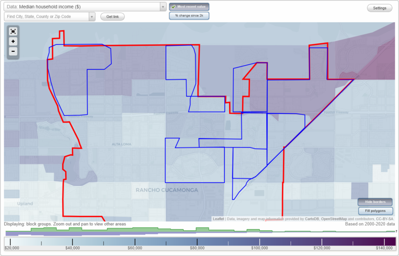
Alta Loma, Caryn, Day Creek, Deer Creek, Downtown, Etiwanda, Rancho Etiwanda, Terra Vista, VictoriaAlta Loma neighborhood in Rancho Cucamonga statistics: (Find on map)
Area: 2.631 square miles
Population: 5,146
Population density:
Median household income in 2021:
Median rent in in 2021:
Male vs Females
Median age
Most popular occupations of males: management occupations (except farmers) (34.9%); sales and office occupations (16.1%); life, physical, and social science occupations (11.9%); education, training, and library occupations (7.5%); production occupations (4.9%); material moving occupations (3.4%); business and financial operations occupations (3.1%)
Most popular occupations of females: education, training, and library occupations (34.5%); sales and office occupations (19.7%); management occupations (except farmers) (17.7%); healthcare practitioners and technical occupations (8.3%); life, physical, and social science occupations (8.2%); service occupations (4.0%); production occupations (2.6%)
Roads and streets: Hillside Rd; Carnelian St; Sapphire St; Almond St; Jasper St; Thoroughbred St; Banyan St; Turquoise Ave; Orchard St; Jennet St; Topaz St; Bella Vista Dr; Highland Ave; Napa Ave; Whirlaway St; Beechwood Dr; Beryl St; la Senda Rd; Lemon Ave; Via Serena; Orange St; Cameo St; Peridot Ave; Pearl St; Rosebud St; Sard St; Vicara Dr; Hidden Farm Rd; Buckthorn Ave; Vinmar Ave; Indigo Ave; Mandarin Ave; Camellia Ct; Appaloosa Ct; Reales St; Hunter Dr; Celestite Ave; Carol Ave; Citrine St; Sunflower Ave; Crestview Pl; Hollyoak Dr; Marble Ave; Trotters Ln; Surrey Ln; Whirlaway Ct; Skyline Rd; Caballero Dr; Della Ave; Amberwood Dr; Laramie Dr; Ranch Gate Rd; Citation Ct; Pumalo St; Galloway St; Inspiration Dr; Buggy Whip Rd; Gardenia Ave; Dresden St; Carrari Ct; Alta Loma Dr; Earl Ct; Falling Tree Ln; Aquamarine Ave; King Ranch Rd; Moonstone Ave; Via el Dorado; la Senda Ct; Sunstone Ave; Wilson Ct; Via Paraiso St; Via Verde St; Cherry Ln; Gateway Rd; Brittany Ln; Laredo Pl; Appaloosa St; Quarter Horse Ln; la Colina Dr; Ridgeway Rd; Castle Ct; Eastwood Ave; Moon Ct; Delphin Pl; Indigo Ct; Napa Ct; Henry St; Turk St; Vinmar Ct; Dresden Ct; Fox Ct; Drexel Ct; Exeter Ct; Crestview Ct; Mojave Dr; Marble Ct; Lomas Ct; Peridot Ct; Shire Ct; Welsh Ct.
Other features: Sunstone.
Other features: Strang Ln.
Alta Loma neighborhood detailed profile
Area: 2.631 square miles
Population: 5,146
Population density:
| Alta Loma: | 1,956 people per square mile |
| Rancho Cucamonga: | 4,677 people per square mile |
Median household income in 2021:
| Alta Loma: | $141,190 |
| Rancho Cucamonga: | $83,850 |
Median rent in in 2021:
| Alta Loma: | $1,205 |
| Rancho Cucamonga: | $1,863 |
Male vs Females
| Males: | 2,276 |
| Females: | 2,870 |
Median age
| Males: | 49.8 years |
| Females: | 43.3 years |
Most popular occupations of males: management occupations (except farmers) (34.9%); sales and office occupations (16.1%); life, physical, and social science occupations (11.9%); education, training, and library occupations (7.5%); production occupations (4.9%); material moving occupations (3.4%); business and financial operations occupations (3.1%)
Most popular occupations of females: education, training, and library occupations (34.5%); sales and office occupations (19.7%); management occupations (except farmers) (17.7%); healthcare practitioners and technical occupations (8.3%); life, physical, and social science occupations (8.2%); service occupations (4.0%); production occupations (2.6%)
Roads and streets: Hillside Rd; Carnelian St; Sapphire St; Almond St; Jasper St; Thoroughbred St; Banyan St; Turquoise Ave; Orchard St; Jennet St; Topaz St; Bella Vista Dr; Highland Ave; Napa Ave; Whirlaway St; Beechwood Dr; Beryl St; la Senda Rd; Lemon Ave; Via Serena; Orange St; Cameo St; Peridot Ave; Pearl St; Rosebud St; Sard St; Vicara Dr; Hidden Farm Rd; Buckthorn Ave; Vinmar Ave; Indigo Ave; Mandarin Ave; Camellia Ct; Appaloosa Ct; Reales St; Hunter Dr; Celestite Ave; Carol Ave; Citrine St; Sunflower Ave; Crestview Pl; Hollyoak Dr; Marble Ave; Trotters Ln; Surrey Ln; Whirlaway Ct; Skyline Rd; Caballero Dr; Della Ave; Amberwood Dr; Laramie Dr; Ranch Gate Rd; Citation Ct; Pumalo St; Galloway St; Inspiration Dr; Buggy Whip Rd; Gardenia Ave; Dresden St; Carrari Ct; Alta Loma Dr; Earl Ct; Falling Tree Ln; Aquamarine Ave; King Ranch Rd; Moonstone Ave; Via el Dorado; la Senda Ct; Sunstone Ave; Wilson Ct; Via Paraiso St; Via Verde St; Cherry Ln; Gateway Rd; Brittany Ln; Laredo Pl; Appaloosa St; Quarter Horse Ln; la Colina Dr; Ridgeway Rd; Castle Ct; Eastwood Ave; Moon Ct; Delphin Pl; Indigo Ct; Napa Ct; Henry St; Turk St; Vinmar Ct; Dresden Ct; Fox Ct; Drexel Ct; Exeter Ct; Crestview Ct; Mojave Dr; Marble Ct; Lomas Ct; Peridot Ct; Shire Ct; Welsh Ct.
Other features: Sunstone.
Other features: Strang Ln.
Alta Loma neighborhood detailed profile
Caryn neighborhood in Rancho Cucamonga statistics: (Find on map)
Area: 0.472 square miles
Highways in this neighborhood: State Rte 210.
Roads and streets: Vintage Dr; Sierra Crest Vw Lp; Terrace Vw Lp; Netherlands Vw Lp; Hillview Loop; Milliken Ave; Morning Pl; Mount Wilson Ct (Mt Wilson Ct); Softwind Pl; White Mountain Ct; Mt Gunnison Ct (Mount Gunnison Ct); Mt Cambridge Ct (Mount Cambridge Ct); Mt Johnson Ct (Mount Johnson Ct); Highview Dr; Mount Wallace Ct; Pyramid Peak Ct; Copper Pass Ct; Mt Lassen Ct (Mount Lassen Ct); Summerside Ln (Summerside Dr); Mount Baker Ct; Mount Sterling Ct; Mount Everett Ct; Mount Rainer Ct; Mt Royal Ct; Mt Harvard Ct; Tioga Peak Ct; Mount Ritter St (Mt Ritter St); Santiago Peak Ct; Mount Hood Ct; Meadow Glen Pl; Hillview Loop S; Mineral Peak Ct; Mammoth Peak Ct; Puma Pl; Mt Baldwin Ct; Mount Waverly Ct (Mt Waverly Ct); Mt Jefferson Dr (Mount Jefferson Dr); Mt San Antonio St (Mount San Antonio Ct); el Capitan Ct; Antler Peak Ct; Silverwood Pl; Mt Whitney Ct; Rochester Ave; Mt Palomar St (Mount Palomar St); Sunny Hills Pl; Pinnacle Peak Ct; Skyview Ln; Mount Miriah Dr (Mt Miriah Dr); Mount Baxter Ct (Mount Baxter St); Mount Sherman Ct; Pikes Peak Ct; Mt Abbott Ct; Reflection Dr; Twilight Pl; Kettle Peak Pl; Cougar Ct; Donner Pass Ct; Bobcat Ct; Starview Pl; Moonshadow Pl; Mount Bend Pl; Starview Ct; Eagle Peak Pl; Silver Sun Ln; Calico Peak Pl; Crestridge Ct; Oak Brook Ct; Mt Wellington Ct; Rainbow Falls Ct; Mount Rushmore Pl (Mt Rushmore Pl); Mt Cook Ct (Mount Cook Ct); Butler Peak Pl; Panorama Ct; Hilltop Ct; Mt Baldy Pl; Sunridge Ct; Woodland Ct; Teton Peak Ct; Mt Pinos Ct (Mount Pinos Ct).
Other features: Deer Crk.
Caryn neighborhood detailed profile
Day Creek neighborhood in Rancho Cucamonga statistics: (Find on map)
Area: 1.396 square miles
Roads and streets: Etiwanda Ave; Day Creek Blvd; Vintage Dr; Banyon St (Summit Ave); 24th St (Wilson Ave); Wilson Ave; Banyan St; Altura Dr; Hanley Ave; Split Rein Dr; E Rancho Estates Pl; Stoneview Rd; Laurel Blossom Pl; Arena Dr; Blackstone Dr; Taylor Canyon Pl; 25th St; Amber Ln; Countrywood Pl; High Horse Dr; Ridgecrest Dr; Challendon Dr; Golden Trails Ave; N Overlook Dr; Canyon Meadows Dr; Churchill Dr; Parke Cir; Tejas Ct; Keenland Dr; Carmello Ct; W Rancho Estates Pl; Alvarado Pl; Wolfson Dr; Dapple Dr; Cervantes Pl; N Rim Way; Rock Creek Rd; Richfield Dr; Vista Verde Dr; Cambria Dr; Goodwood Dr; Saddle Tree Pl; Golden Prairie Dr; Silver Saddle Dr; Clydesdale Dr; Secretariat Dr; Carmel Knolls Dr; Hidden Brook Pl; Bluegrass Ave; Penrose Pl; Bridge Water Dr; Greentree Dr; Duncaster Pl; Danville Dr; Appian Dr; Mountain Ash Ct; Oldenberg Ct; Chicory Ct; Stable Falls Ave; Greyville Pl; E Overlook Dr; W Overlook Dr; Newmarket Pl; Roseville Dr; Windstar Dr; Ironstone Dr; N Bend Ct; Saddlehorn Dr; Bahama Ct; Rancho Vista Pl; Prospect Pl; Canter Dr; Rutland Ct; Winterberry Pl; Cedar Hill Pl; Glen Ridge Ct; Ascot Pl; Pacific Crest Pl; Cheyenne Ct; Rodeo Dr; Middlebury Ct; Greenwood; Sandown Pl; Sagebrush Ct; Show Horse Way; Colt Dr; Socorro Dr; Colt Ct; Black Creek Ct; Linda Vista Ct; Triple Crown Ct; Los Altos Ct; White Rock Dr; Filly Ct; Cimarron Ct; Rocking Horse Pl; Silver Ridge Rd; Meadowbrook Ct; Oaklawn Pl; Oakridge Ct; Rustic Oak Ct; Camarrio Ct; Jackson Pl; del Norte Pl; Sandhill Pl; Polo Pl; Stagecoach Ct; Kentucky Derby Ct; Golden Spur Pl; Blue Spruce Dr; San Carlos Ct; Preakness Pl; Quarry Ct; Lost Trail Ct; Aspen Meadows Ct; Still Creek Ct; Ludlow Pl; Rock Garden Ct; San Pablo Ct; Bermuda Ct; Madre Pl; Pebble Hill Ct; Estates Way; Steeplechase Ct; Bronco Pl; Seabiscuit Ct; Dundee Ct; Aruba Ct; Lusitano Ct; Vaquero Ct; Brookstone Pl; Chandler Ct; Horseshoe Ct; Rosecroft Ct; Las Brisas Ct; Kendall Ct; Moondance Ct.
Day Creek neighborhood detailed profile
Deer Creek neighborhood in Rancho Cucamonga statistics: (Find on map)
Area: 0.983 square miles
Roads and streets: Hillside Rd; Ringstem Dr; Deer Canyon Dr; Wilson Ave; Canistel Ave; Boulder Canyon Rd; Tackstem St; Beechwood Dr; Valinda Ave; High Meadow Pl; Wilderness Dr; Paddock Pl; Carriage Dr; Ridge Canyon Rd; Apple Ln; Cedar Mountain Dr; Stone River Dr; Fredericksburg Ave; Carriage Pl; Antietam Dr; Morning Star Dr; Cedar Creek Dr; Seven Pines Dr; Shiloh Ct; Lippizan Pl; Equine Pl; Shady Lane Ct; Vicksburg Ct; Stallion Way; Peach Tree Ln; Running Creek Ln; Silver Spur Ct; Bonita Ave; Clover Pl; Gettysburg Dr; Rodeo Rd; Date Ave; Appomatox Ct; Ranch Dr; Broken Arrow Rd; Bramble Ct; Martingale Way; Trails End Ct; Cobblestone Ln; Bridle Pl; Cross Keys Dr; Lone Acres Ct; Northwind Pl; Palomino Pl; Calico Ct; Calypso Ct; Morgan Pl; Buckskin Ct; Ginger Ct; Cactus Ct; Hidden Trl Dr; Granada Ct; Cold Harbor Dr; Deer Creek Ln; Running Fawn Ct; Deer Run Ct; Corral Ct; Shadow Ln; Roan Ct; Sundowner Ct.
Deer Creek neighborhood detailed profile
Downtown neighborhood in Rancho Cucamonga statistics: (Find on map)
Area: 0.831 square miles
Roads and streets: Church St; Victoria Gardens Ln; Day Creek Blvd; N Main St; Versailles St; Cultural Center Dr; Victoria Park Ln; Arbor Ln; S Main St; Etiwanda Ave; Monet Ave; Long Meadow Dr; Wild Horse Way; Eden Ave; Colonnade Dr; Kew Pl; Monticello Ave; Royal Oaks Dr; Spring Mountain Dr; Winery Dr; Chimney Rock Dr; Mosaic Dr; Madrigal Dr; Sonoma Creek Ct; Calistoga Pl; Kenwood Pl; Iron Horse Pl; Pine Ridge Pl; Elegance Dr; Dry Creek Dr; Vintner Dr; Waterbrook Dr; Wilson Creek Dr; Bridlewood Dr; Silver Rose Ct; Los Olivos Pl; Silverado Trail Pl; Elk Cove Ct; Penfold Dr; Rutherford Dr; Reserve Pl; Meritage Ct; Appellation Dr; Duck Creek Pl; Estancia Ct; Alcazar Pl; Silver Oak Pl; Waterland Pl; Roundhill Pl; Oakford Ct; Saintsbury Pl; Alderbrook Dr; Freestone Ct; Pavilion Gardens Pl; (I 15 Fwy S); Chalk Hill Pl; Hess Pl; Hitching Post Ct; Vine Crest Pl; Miller Ave; Marquis Pl; Mosiac Dr; Old Port Ct; Tiffany Pl; Rosemount Ct; Wine Cellar Ct; Covey Run Ct; Cloudy Bay Ct.
Downtown neighborhood detailed profile
Etiwanda neighborhood in Rancho Cucamonga statistics: (Find on map)
Area: 3.746 square miles
Limited-access highways (interstate or state) in this neighborhood: Ontario Fwy (I- 15).
Highways in this neighborhood: State Rte 210.
Roads and streets: I 15 Fwy S; East Ave; Summit Ave (Banyon St); San Sevaine Rd; Fisher Dr (State Hwy 30, Highland Ave); Victoria St; Smokestone St; Wardman Bullock Rd; Crestline Pl; Ridgeline Pl; Blue Gum Dr; Summit Ave (Wilson Ave); Aggazzitti Rd (Aggosetti Rd); State Hwy 30 (Highland Ave); Crescenta Way; Pecan Ave; Regina Dr; Chickasaw Rd; Young's Cyn Rd; Cherry Ave; Colonial Dr; Baseline Rd; Dicarlo Pl; Almond Ave; Rogue River Dr; Vai Brothers Dr; Johnston Pl; Whitestone Pl; Bungalow Way; Windy Grove Dr; Annandale Ln; San Dimas Ln; Via Tesoro Dr; Ashton Pl; Via Regallo Dr; Claremont Ln; Santa Ynez Pl; San Segundo Dr; Arapaho Rd; Frost Dr; Shepherd Dr; Egglestone Pl; Flagstone Pl; Norcia Dr; Mulberry St; Starstone Pl; Redwood Dr; Dove Canyon Way; Laurel Tree Dr; Cassia St; Pinecone Way; Arcadia Way; Hastings Ranch Ln; Henderson Dr; Catalpa St; San Antonio Dr; Chateau Dr; Hoppe Dr; Mueuer Ct; Soledad Way; Crawford Pl; Dona Way; Oakleaf Way; Quail Ct; Colonbero Rd; Carnesi Dr; Emmett Way; Acorn Pl; Darkwood Way; Hickox Ln; Brownstone Pl; Base Line Rd; Harness Dr; Covina Pl; Williamson Rd; Eaglewood Pl; Sunshine Dr; Pinon St; Green Canyon Dr; Vista St; Larrera St; Glendora Dr; Lima Dr; Dove Wood Dr; Jeremy Ct; Glendale Ct; Bradbury Way; Jordan Ct; Highstone Manor Ct; River Birch; Forester Pl; Los Cedros Ave; Beech Ave; Via Brunello Pl; Munigo Ct; Murietta Ct; Baseline Ave; Hummingbird Way; Blossom Pl; Baldwin Ct; Guidera Dr; Choctaw Pl; Riley Ct; Pelican Dr; Bluebell Pl; Campanella Pl; Shooting Star Way; Montclair Ct; Shelby Pl; Little Oak Ct; Ash Ave; Pear Ave; Torrey Pine Ct; Rolling Pastures Pl; Westwood Way; Greenpine Ct; Ingvaldsen Pl; Grovewood Pl; Los Robles Ct; Greenstone Dr; Parkview Way; Falling Oak Dr; Padre Ct; White Fir Ct; San Marino Way; Pellburne Way; Alhambra Ct; Carrotwood Ct; Galliano Ave; Roberts Pl; Horse Thief Pl; Truckee Pl; Kittyhawk Way; Sheep Creek Ct; Koch Pl; Philly Dr; Garrett Ave; Blue Gum Ct; Raintree Pl; Brisas Ct; Galliano Ct; Stephens Pl; Shasta Ct; Oakcrest Ct; Hacienda Ct; Green Glen Ct; Pinebluff Ct; Strawberry Pl; Purisima Pl; Colony Ct; San Gabriel Ct; Sanchez Ct; Congemi Ct; Lancia Ct; Banyan St; Mandala Ave; Coppi Ct; Owens Dr; Carriage Trails Ct; Opici Ct; Shore Pine Ct; Bautista Way; Cervetti Ave; Gallo Ct; Cashew Way; Fields Pl; Plateau Dr; Rose Way; Russian River Ct; Santa Fe Ct; Via Savino Dr; Ross Ct; Via Savino Pl; Pear Ct; Clark Ct; Columbia Ct; Pasture Ct; Pierson Ct; Altadena Ct; Peak Pl; Park Meadow Pl; Sand Creek Ct; Weeping Willow Ct; Pasadena Ct; Star Tulip Ct; Baine Ct; Goldenstar Ct; Blue Cup Ct; Cajon Creek Ct; Blackfoot Ct; Walnut Grove Ct.
Other features: Flood Control Chnnl; East Etiwanda Crk.
Etiwanda neighborhood detailed profile
Rancho Etiwanda neighborhood in Rancho Cucamonga statistics: (Find on map)
Area: 1.088 square miles
Roads and streets: I 15 Fwy S; East Ave; Victoria St; Fisher Dr (State Hwy 30, Highland Ave); Smokestone St; State Hwy 30 (Highland Ave); Pecan Ave; Colonial Dr; Baseline Rd; Dicarlo Pl; Rogue River Dr; Whitestone Pl; Bungalow Way; Windy Grove Dr; Via Tesoro Dr; Via Regallo Dr; Egglestone Pl; Flagstone Pl; Norcia Dr; Mulberry St; Starstone Pl; Redwood Dr; Catalpa St; Chateau Dr; Mueuer Ct; Crawford Pl; Quail Ct; Carnesi Dr; Emmett Way; Acorn Pl; Brownstone Pl; Base Line Rd; Williamson Rd; Sunshine Dr; Pinon St; Green Canyon Dr; Vista St; Larrera St; Lima Dr; Jeremy Ct; Jordan Ct; Highstone Manor Ct; Forester Pl; Los Cedros Ave; Via Brunello Pl; Munigo Ct; Murietta Ct; Baseline Ave; Riley Ct; Bluebell Pl; Shooting Star Way; Shelby Pl; Ash Ave; Pear Ave; Torrey Pine Ct; Greenstone Dr; Falling Oak Dr; Truckee Pl; Sheep Creek Ct; Raintree Pl; Brisas Ct; Oakcrest Ct; Green Glen Ct; Pinebluff Ct; Strawberry Pl; Owens Dr; Plateau Dr; Russian River Ct; Via Savino Dr; Via Savino Pl; Pear Ct; Columbia Ct; Pasture Ct; Sand Creek Ct; Star Tulip Ct; Goldenstar Ct; Blue Cup Ct; Cajon Creek Ct; Blackfoot Ct.
Other features: Flood Control Chnnl; East Etiwanda Crk.
Rancho Etiwanda neighborhood detailed profile
Terra Vista neighborhood in Rancho Cucamonga statistics: (Find on map)
Area: 1.913 square miles
Highways in this neighborhood: Foothill Blvd (State Hwy 66).
Roads and streets: Church St; Terra Vista Pkwy; Mountain View Dr; Elm Ave; Haven Ave; Spruce Ave; Milliken Ave; Town Center Dr; Rochester Ave; Country View Dr; Constitution Way; Belpine Pl; Malaga Dr; Spyglass Dr; Base Line Rd (Baseline Rd); Parkside Pl; Brandywine Pl; Bunker Hill Dr; Muirfield Dr; Mayten Ave; Declaration Dr; Valencia Ave; Alencon Dr; Stamfield Dr; Sundance Dr; Mansfield Rd; Annapolis Dr; Mountain View Dr S; Daybreak Pl; Plymouth Way; Fitzpatrick Dr; Monument Dr; Corsica Ct; Belvedere Pl; Constitution Ave; Chesterton Dr; Merrimack Pl; Barrett Dr; Meadowlark Pl; Danbury Dr; Brookside Rd; Windsong Pl; Oxford Pl; Palm Meadows Dr; Cardiff Pl; Greenhaven Ave; Weybridge Dr; Woodview Dr; Fulbourn Ct; Fairhaven Pl; Creekbridge St; Parliament Dr; Ambrosia Rd; Addison Rd; Glouchester Dr; Grapevine St; Countryside Dr; Essex Pl; Northview Dr (Northview St); Stonecrest Dr; New England Dr; Revolution Dr; Wildwood Dr; Berwick Dr; Springfield Dr; Continental Pl; de Anza Dr; Rockingham Ct; Orange Blossom Dr; Wellington Pl; Butterfield Pl; Stoneridge Dr; Glenoaks Dr; Cedarbrook Pl; Sunburst Dr; Meyers Dr; Waterbury Pl; Proclamation Pl; Brentwood Dr; Oakdale Dr; Roxbury Pl; Greenacre Dr; Broadmoor Pl; Regent Dr; Weatherly Pl; Hollaway Rd; Greenbriar Pl; St Tropez Dr; Montgomery Dr; Marmande Pl; Quincy Pl; Claridge Dr; Ellena Way; Tangerine Pl; Wild Rose Dr; Celebration Dr; Black Horse Ct; Hutchinson Pl; Downing Ct; Summerfield Pl; Correspondence Pl; Nesbitt Dr; Hardy Ave; Covington Pl; Manhattan Ct; Byron Ave; Springmill Pl; Hastings Ct; Washington Pl; Villa Crest Pl; Oakhurst Dr; Massachusetts Pl; Saybrook Dr; Langham Pl; Hinsdale Pl; Amiata Dr; Franklin Dr; Potomac Ct; Linaro Rd; Tyler Pl; Greenwich Pl; Stonebrook Pl; Worcester Dr; Bunker Dr; Sandpiper Ct; Lancaster Way; Gainey Ct; Calais Ct; Palacio Ct; Warwick Ct; Sierra Linda Ct; Claridge Pl; Barrington Ct; Deerfield Dr; Smallwood Pl; Gage Dr; Glenview Dr; Cascade Ct; Congress Dr; Danner Ct; Westwind Dr; Grandview Dr; Harmony Dr; Freedom Pl; Montecito Ct; Meadowcrest Ct; Emery Pl; Yorktown Ct; Jefferson Ct; Tradition Pl; Sarzana Pl; Dickens Ct; Madison Pl; Hampton Pl; Legacy Pl; Evergreen Dr; Lowell Dr; Mason Pl; Southampton Ct; Chaumont Pl; Stonehaven Pl; Aurora Pl; Newberry Pl; Newburry Pl; Niagara Pl; Birkdale Pl; Vermont Dr; Devonshire Ct; Highgrove Pl; Connecticutt Dr; Buckingham Ct; Hillcrest Ct; Northgate Pl; Schuyler Ct; Clover Ct; Garrison Dr; Morningside Ct; Edgewood Ct; Norfolk Dr; el Dorado Ct; Tarkington Pl; Heathcliff Way; Augusta Dr; Canterbury Ct; Rutledge Ct; Clarisa Pl; Liberation Dr; Weston Pl; Derby Pl; Bolton Pl; Wimbleton Ct; Rhode Island Ct; Radcliff Pl; Biarritz Pl; Cloverdale Ct; Carlisle Pl; Windemere Pl; Duxbury Pl; Locke Pl; Walden Pl; Hinton Ct.
Other features: Deer Crk.
Terra Vista neighborhood detailed profile
Victoria neighborhood in Rancho Cucamonga statistics: (Find on map)
Area: 2.118 square miles
Highways in this neighborhood: Foothill Blvd (State Hwy 66); State Rte 210.
Roads and streets: Base Line Rd (Baseline Rd); Victoria Park Ln; Day Creek Blvd; N Victoria Windrows Loop; Church St; Victoria Gardens Ln; Etiwanda Ave; N Main St; Highland Ave; Monet Ave; Versailles St; Cultural Center Dr; Arbor Ln; S Main St; Palo Verde Pl; Candela Dr; Plum Way; Bougainvillea Way; Long Meadow Dr; Wild Horse Way; Eden Ave; Pistache St; Victoria St; Colonnade Dr; Kew Pl; Monticello Ave; S Victoria Windrows Loop; Tipu Pl; Saddleridge Dr; Morning Glory Dr; Ellena Way; Sugar Gum St; Royal Oaks Dr; Spring Mountain Dr; Farrington St; Ellena E; Fontaine Pl; San Carmela Ct; Carob Ave; Amelia Dr; Atwood St; Aloe Ct; Turning Leaf Pl; Coriander Ct; Dunmore Pl; Nasturtium Dr; Winery Dr; Santolina Pl; Mimosa Pl; Trivento Pl; Travis Pl; Silverberry St; Peach Pl; Chimney Rock Dr; Cumberland Ct; Mosaic Dr; Basswood Pl; Kalmia St; Grape Pl; Westhaven Pl; Lantana Dr; Taggart Pl; Wintergreen St; Sevilla Pl; Silktassel Dr; Madrigal Dr; Sonoma Creek Ct; Calistoga Pl; Ravenswood Pl; Sweetgum Dr; Comiso Way; Kenwood Pl; Carissa Ct; Larino Dr; Iron Horse Pl; Firethorn St; Blazing Star Ct; Pine Ridge Pl; Snapdragon St; Rochester Ave; Goldenrain Way; Locust Ave; Rockrose Ave; Elegance Dr; Dry Creek Dr; Mint Ct; Huntley Dr; Vintner Dr; Waterbrook Dr; Basil St; Sagemont Dr; Wilson Creek Dr; Victoria Windrows Loop; Buttercup Way; Harwick Dr; Bridlewood Dr; Walcott Pl; Daisy Ct; Craig Dr; Lily Ct; Silver Rose Ct; Los Olivos Pl; Barberry St; Silverado Trail Pl; Elk Cove Ct; Penfold Dr; Gainsborough Ct; Columbine Way; Camassia Ct; Fuchsia Dr; Broken Branch Dr; Saratoga St; Rutherford Dr; Ironbark Dr; Pavola Dr; Redbud Pl; Altari Pl; Sappada Pl; Reserve Pl; Hazelnut Way; Arabis Pl; Meritage Ct; George Ct; Daphne Dr; Dove Tree Dr; Scalea Pl; Jessie Ct; Carano Pl; Appellation Dr; Coral Tree Rd; Duck Creek Pl; Foxtail Ct; Riva Pl; Province St; Estancia Ct; Rosewood Pl; Terni Pl; Breno Pl; Twinspur Pl; Alcazar Pl; Silver Oak Pl; Waterland Pl; Bellflower Ct; Thistle Dr; William Ridge Dr; Sapri Pl; Santo Pl; Primrose Pl; Roundhill Pl; Marconi Pl; Powell Pl; Dogwood Pl; Bettola Pl; Venosa Pl; Huckleberry Ct; Tilden Dr; Oakford Ct; Fermo Pl; Montella Dr; Aster Ct; Begonia Ct; Tresenda Dr; Saintsbury Pl; Bronte Pl; Triola Dr; Forenza Pl; Letini Dr; Lucerne Ct; Fasano Pl; Brienza Pl; Kenyon Way; Elderberry Ct; Alderbrook Dr; Freestone Ct; Pavilion Gardens Pl; Lotus Ct; Cosenza Pl; Tamarisk Dr; (I 15 Fwy S); Tindari Pl; Chalk Hill Pl; Renwick Dr; Bamboo Pl; Citrus Pl; Skylark Pl; Larkspur Pl; Sanza Pl; Iris Pl; Lesina Pl; Hess Pl; Ellena E (Ellena Dr); Corte Pl; Pioneer Pl; Bertrand Dr; Hitching Post Ct; Pinehurst Dr; Vine Crest Pl; Miller Ave; Myrtle Ct; Geranium Pl; Verbena Ct; Camphor Ct; Shenandoah Dr; Marquis Pl; Harne Ct; Chaney Ct; Mosiac Dr; Nicolet Ct; Old Port Ct; Henshaw Ct; Tiffany Pl; Wanona Pl; Spencer Ct; Hollow Tree Dr; Virginia Pl; Rosemary Ct; Margate Ct; Jasmine Ct; Durness Pl; Lorenzo Dr; Zinnia Ct; Rosa Dr; Maidenhair Ct; Columbine Ct; Trillium Ct; Poppy Ct; Orchid Ct; Isle Ct; Saffron Ct; Violet Ct; Marigold Ct; Townsend Ct; Swanson Pl; Adria Ln; Bougainvillea Ct; Silk Oak Ct; Tulip Ct; Veronica Ct; Casoli Pl; Lilac Ct; Crema Pl; Foxglove Ct; Crocus Ct; Berra Rd; Dahlia Ct; Blue Mist Dr; Rosemount Ct; Azalea Ct; Wine Cellar Ct; Clear Lake Ct; Covey Run Ct; Cloudy Bay Ct.
Other features: Day Creek Chnnl.
Victoria neighborhood detailed profile