Calhoun Isles neighborhood in Minneapolis, Minnesota (MN), 55403, 55405, 55408, 55416 detailed profile
Settings
X

Business Search - 14 Million verified businesses
Area: 5.520 square miles
Population: 33,390
Population density:
| Calhoun Isles: | 6,049 people per square mile |
| Minneapolis: | 7,744 people per square mile |

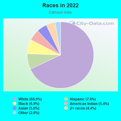
- 25,70768.0%White
- 2,8647.6%Hispanic or Latino
- 2,6106.9%Black
- 2,0465.4%American Indian
- 1,9025.0%Asian
- 1,6804.4%Two or more races
- 9892.6%Some other race
Distribution of median household income
![Distribution of median household income]()
- 2,484Less than $10,000
- 1,902$10,000 to $19,999
- 1,506$20,000 to $29,999
- 1,840$30,000 to $39,999
- 2,844$40,000 to $49,999
- 1,678$50,000 to $59,999
- 2,285$60,000 to $74,999
- 2,542$75,000 to $99,999
- 1,814$100,000 to $124,999
- 1,983$125,000 to $149,999
- 1,454$150,000 to $199,999
- 3,485$200,000 or more

Distribution of owner-occupied house/condo value
![Distribution of owner-occupied house/condo value]()
- 1,689Less than $50,000
- 7,442$50,000 to $99,999
- 1,485$100,000 to $149,999
- 809$150,000 to $199,999
- 621$200,000 to $249,999
- 495$250,000 to $299,999
- 1,309$300,000 to $399,999
- 1,318$400,000 to $499,999
- 1,699$500,000 to $749,999
- 1,055$750,000 to $999,999
- 2,364$1,000,000 or more

Distribution of rent paid by renters
![Distribution of rent paid by renters]()
- 1,205Less than $100
- 4,296$100 to $199
- 7,864$200 to $299
- 3,178$300 to $399
- 2,267$400 to $499
- 4,833$500 to $599
- 3,136$600 to $699
- 2,487$700 to $799
- 2,178$800 to $899
- 2,109$900 to $999
- 3,356$1,000 to $1,249
- 2,992$1,250 to $1,499
- 3,237$1,500 to $1,999
- 4,251$2,000 or more

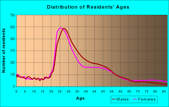
| Males: | 17,594 |
| Females: | 15,796 |
Males:
| This neighborhood: | 36.8 years |
| Whole city: | 33.3 years |
| This neighborhood: | 37.3 years |
| Whole city: | 33.2 years |
Average household size:
| Calhoun Isles: | 2.5 people |
| Minneapolis: | 2.1 people |
Percentage of family households:
| Calhoun Isles: | 22.0% |
| Minneapolis: | 34.1% |
| Here: | 25.4% |
| Minneapolis: | 29.8% |
Percentage of married-couple families with children (among all households):
| Calhoun Isles: | 47.2% |
| Minneapolis: | 31.8% |
Percentage of single-mother households (among all households):
| Calhoun Isles: | 12.8% |
| Minneapolis: | 10.5% |
Percentage of never married males 15 years old and over:
Percentage of never married females 15 years old and over:
| Calhoun Isles: | 32.9% |
| Minneapolis: | 27.0% |
Percentage of never married females 15 years old and over:
| Calhoun Isles: | 26.3% |
| city: | 25.4% |
Percentage of people that speak English not well or not at all:
| Calhoun Isles: | 0.4% |
| Minneapolis: | 3.8% |
Percentage of people born in this state:
Percentage of people born in another U.S. state:
Percentage of native residents but born outside the U.S.:
Percentage of foreign born residents:
| Here: | 49.9% |
| Minneapolis: | 51.9% |
Percentage of people born in another U.S. state:
| Calhoun Isles: | 39.9% |
| Minneapolis: | 31.8% |
Percentage of native residents but born outside the U.S.:
| Here: | 1.2% |
| city: | 1.5% |
Percentage of foreign born residents:
| Here: | 9.1% |
| Minneapolis: | 14.7% |
Owner-occupied
Renter-occupied

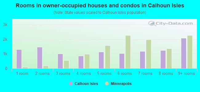
- Rooms in owner-occupied houses and condos in Calhoun Isles
- 1,3031 room
- 1,4672 rooms
- 1,0003 rooms
- 8564 rooms
- 1,1415 rooms
- 1,0246 rooms
- 1,1827 rooms
- 1,2378 rooms
- 2,0709+ rooms
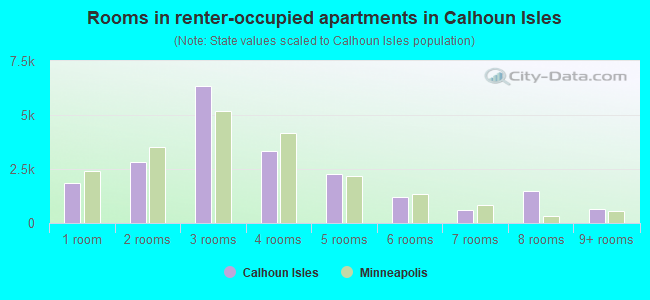
- Rooms in renter-occupied apartments in Calhoun Isles
- 1,8451 room
- 2,8112 rooms
- 6,3333 rooms
- 3,3214 rooms
- 2,2525 rooms
- 1,2216 rooms
- 5877 rooms
- 1,4608 rooms
- 6399+ rooms
Owner-occupied
Renter-occupied
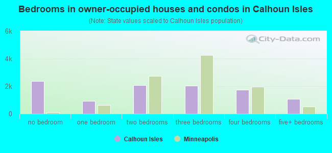
- Bedrooms in owner-occupied houses and condos in Calhoun Isles
- 2,373no bedroom
- 9141 bedroom
- 2,0822 bedrooms
- 2,0243 bedrooms
- 1,7574 bedrooms
- 1,0695+ bedrooms
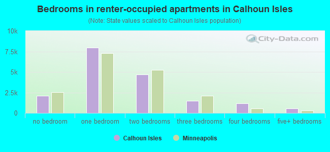
- Bedrooms in renter-occupied apartments in Calhoun Isles
- 2,123no bedroom
- 7,9331 bedroom
- 4,7172 bedrooms
- 1,5123 bedrooms
- 1,1444 bedrooms
- 5765+ bedrooms
Average number of cars or other vehicles available in houses/condos:
Average number of cars or other vehicles available in apartments:
| This neighborhood: | |
| Minneapolis: |
Average number of cars or other vehicles available in apartments:
| Here: | |
| city: |
Percentage of units with a mortgage:
| Calhoun Isles: | 69.9% |
| Minneapolis: | 71.8% |
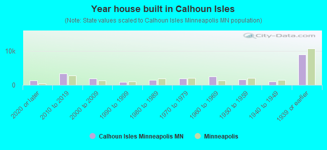
- Year house built in Calhoun Isles
- 1,2752020 or later
- 3,3382010 to 2019
- 1,9252000 to 2009
- 8551990 to 1999
- 1,4021980 to 1989
- 1,9351970 to 1979
- 2,4531960 to 1969
- 1,6641950 to 1959
- 1,0741940 to 1949
- 8,9551939 or earlier
City-data.com crime index for city in 2020 (higher means more crime):
| City: | 600.2 |
| U.S. average: | 219.5 |
Travel time to work (commute)
![Travel time to work (commute)]()
- 438Less than 5 minutes
- 1,0945 to 9 minutes
- 2,62910 to 14 minutes
- 3,31615 to 19 minutes
- 3,64120 to 24 minutes
- 2,00625 to 29 minutes
- 2,60430 to 34 minutes
- 67035 to 39 minutes
- 53740 to 44 minutes
- 99645 to 59 minutes
- 52960 to 89 minutes
- 19590 or more minutes

Means of transportation to work
![Means of transportation to work]()
- 56.0%13,504Drove a car alone
- 5.3%1,279Carpooled
- 10.6%2,552Bus
- 6.4%1,531Subway or elevated rail
- 5.2%1,245Light rail, streetcar or trolley
- 10.8%2,595Ferryboat
- 9.7%2,348Taxi
- 1.3%311Motorcycle
- 5.2%1,243Bicycle
- 6.7%1,606Walked
- 4.1%984Other means
- 23.7%5,700Worked at home

Time leaving home to go to work
![Time leaving home to go to work]()
- 33012:00 a.m. to 4:59 a.m.
- 3565:00 a.m. to 5:29 a.m.
- 3565:30 a.m. to 5:59 a.m.
- 6526:00 a.m. to 6:29 a.m.
- 1,3806:30 a.m. to 6:59 a.m.
- 2,4117:00 a.m. to 7:29 a.m.
- 3,0067:30 a.m. to 7:59 a.m.
- 2,9358:00 a.m. to 8:29 a.m.
- 1,7208:30 a.m. to 8:59 a.m.
- 1,5299:00 a.m. to 9:59 a.m.
- 1,07810:00 a.m. to 10:59 a.m.
- 39411:00 a.m. to 11:59 a.m.
- 1,46812:00 p.m. to 3:59 p.m.
- 1,1284:00 p.m. to 11:59 p.m.

Occupations of males:
- Percentage of males in management occupations (except farmers):
Here: 17.9% city: 12.1%
- Percentage of males in business and financial operations occupations:
Here: 13.2% city: 9.1%
- Percentage of males in computer and mathematical occupations:
Here: 9.5% city: 8.4%
- Percentage of males in architecture and engineering occupations:
Here: 6.3% city: 4.6%
- Percentage of males in life, physical, and social science occupations:
Here: 2.6% city: 2.0%
- Percentage of males in community and social services occupations:
Here: 2.2% city: 1.8%
- Percentage of males in legal occupations:
Here: 2.9% city: 2.0%
- Percentage of males in education, training, and library occupations:
Here: 4.0% city: 5.2%
- Percentage of males in arts, design, entertainment, sports, and media occupations:
Here: 3.8% city: 4.0%
- Percentage of males in healthcare practitioners and technical occupations:
Here: 4.5% city: 3.6%
- Percentage of males in service occupations:
Here: 8.0% city: 12.6%
- Percentage of males in sales and office occupations:
Here: 16.6% city: 15.3%
- Percentage of males in construction, extraction, and maintenance occupations:
Here: 1.8% city: 3.3%
- Percentage of males in production occupations:
Here: 2.0% city: 5.8%
- Percentage of males in transportation occupations:
Here: 2.0% city: 4.1%
- Percentage of males in material moving occupations:
Here: 1.5% city: 3.6%
Occupations of females:
- Percentage of females in management occupations (except farmers):
Here: 12.1% city: 11.4%
- Percentage of females in business and financial operations occupations:
Here: 16.8% city: 9.8%
- Percentage of females in computer and mathematical occupations:
Here: 3.5% city: 2.6%
- Percentage of females in life, physical, and social science occupations:
Here: 2.3% city: 2.3%
- Percentage of females in community and social services occupations:
Here: 6.0% city: 3.8%
- Percentage of females in legal occupations:
Here: 3.8% city: 2.3%
- Percentage of females in education, training, and library occupations:
Here: 8.7% city: 10.6%
- Percentage of females in arts, design, entertainment, sports, and media occupations:
Here: 8.3% city: 5.6%
- Percentage of females in healthcare practitioners and technical occupations:
Here: 7.0% city: 8.3%
- Percentage of females in service occupations:
Here: 10.2% city: 17.8%
- Percentage of females in sales and office occupations:
Here: 17.5% city: 18.7%
- Percentage of females in production occupations:
Here: 1.4% city: 2.7%
- Percentage of females in material moving occupations:
Here: 1.0% city: 1.5%
Percentage of people 16-64 in Armed Forces:
| Calhoun Isles: | 0.0% |
| Minneapolis: | 0.1% |
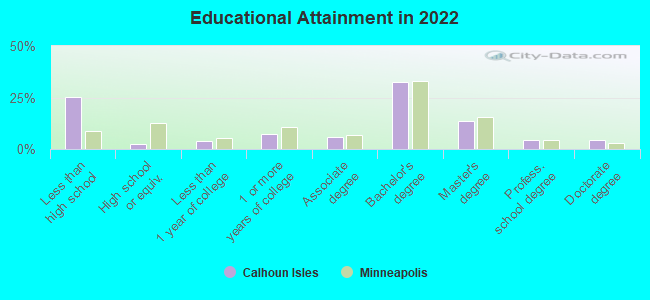
Education in this neighborhood (subdivision or community):
- Percentage of people 3 years and older in K-12 schools:
Calhoun Isles: 14.6% Minneapolis: 14.0%
- Percentage of people 3 years and older in undergraduate colleges:
Calhoun Isles: 5.7% Minneapolis: 8.6%
- Percentage of people 3 years and older in grad. or professional schools:
Calhoun Isles: 9.8% Minneapolis: 2.9%
- Percentage of students K-12 enrolled in private schools:
Calhoun Isles: 54.4% Minneapolis: 14.1%
Percentage of population below poverty level:
| Calhoun Isles: | 8.1% |
| Minneapolis: | 17.2% |
Percentage of married-couple families with both working:
| Calhoun Isles: | 126.3% |
| Minneapolis: | 73.9% |
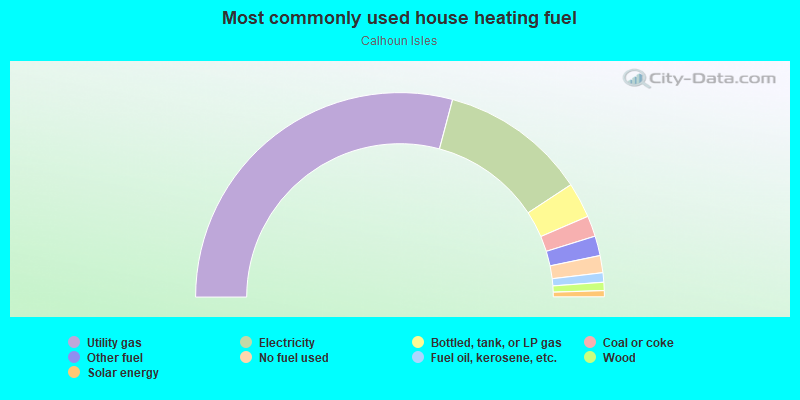
- 58.3%Utility gas
- 23.2%Electricity
- 5.6%Bottled, tank, or LP gas
- 3.3%Coal or coke
- 3.1%Other fuel
- 2.7%No fuel used
- 1.5%Fuel oil, kerosene, etc.
- 1.3%Wood
- 1.0%Solar energy
Limited-access highways (interstate or state) in this neighborhood:
US Hwy 12 (I- 394)
Length: 2.59 miles
Directions: E-W, SW-NE
Directions: E-W, SW-NE
US Hwy 52 (I- 94, US Hwy 12)
Length: 0.66 miles
Directions: N-S, SE-NW
Directions: N-S, SE-NW
Roads and streets:
W Lake St (Co Rd 5)
Length: 2.84 miles
Directions: E-W, SE-NW
Address range: 700 to 3806
Directions: E-W, SE-NW
Address range: 700 to 3806
Kenwood Pkwy
Length: 2.50 miles
Directions: E-W, N-S, SE-NW, SW-NE
Address range: 100 to 2299
Directions: E-W, N-S, SE-NW, SW-NE
Address range: 100 to 2299
Bryant Ave S
Length: 2.21 miles
Directions: E-W, N-S, SE-NW, SW-NE
Address range: 1600 to 3599
Directions: E-W, N-S, SE-NW, SW-NE
Address range: 1600 to 3599
Lyndale Ave S
Length: 2.21 miles
Direction: N-S
Address range: 1400 to 3599
Direction: N-S
Address range: 1400 to 3599
Dupont Ave S
Length: 2.14 miles
Directions: N-S, SW-NE
Address range: 1600 to 3599
Directions: N-S, SW-NE
Address range: 1600 to 3599
Irving Ave S
Length: 2.13 miles
Directions: N-S, SW-NE
Address range: 1700 to 3599
Directions: N-S, SW-NE
Address range: 1700 to 3599
Humboldt Ave S
Length: 2.12 miles
Directions: N-S, SE-NW, SW-NE
Address range: 1700 to 3599
Directions: N-S, SE-NW, SW-NE
Address range: 1700 to 3599
Hennepin Ave S
Length: 2.08 miles
Directions: N-S, SW-NE
Address range: 2000 to 3599
Directions: N-S, SW-NE
Address range: 2000 to 3599
Emerson Ave S
Length: 2.08 miles
Directions: N-S, SE-NW, SW-NE
Address range: 1500 to 3599
Directions: N-S, SE-NW, SW-NE
Address range: 1500 to 3599
Colfax Ave S
Length: 2.05 miles
Directions: N-S, SE-NW, SW-NE
Address range: 1700 to 3599
Directions: N-S, SE-NW, SW-NE
Address range: 1700 to 3599
W Lake of the Isles Pkwy
Length: 2.02 miles
Directions: E-W, N-S, SE-NW, SW-NE
Address range: 2000 to 2899
Directions: E-W, N-S, SE-NW, SW-NE
Address range: 2000 to 2899
W 28th St
Length: 2.01 miles
Directions: E-W, SW-NE
Address range: 700 to 3803
Directions: E-W, SW-NE
Address range: 700 to 3803
Fremont Ave S
Length: 1.97 miles
Directions: E-W, N-S, SW-NE
Address range: 1701 to 3599
Directions: E-W, N-S, SW-NE
Address range: 1701 to 3599
Aldrich Ave S
Length: 1.81 miles
Directions: N-S, SE-NW, SW-NE
Address range: 1900 to 3599
Directions: N-S, SE-NW, SW-NE
Address range: 1900 to 3599
Girard Ave S
Length: 1.76 miles
Directions: N-S, SE-NW, SW-NE
Address range: 1700 to 3599
Directions: N-S, SE-NW, SW-NE
Address range: 1700 to 3599
W Franklin Ave
Length: 1.73 miles
Directions: E-W, SE-NW, SW-NE
Address range: 700 to 3799
Directions: E-W, SE-NW, SW-NE
Address range: 700 to 3799
W 32nd St
Length: 1.69 miles
Direction: E-W
Address range: 700 to 3899
Direction: E-W
Address range: 700 to 3899
Cedar Lake Pkwy
Length: 1.64 miles
Directions: E-W, N-S, SE-NW, SW-NE
Address range: 1118 to 3699
Directions: E-W, N-S, SE-NW, SW-NE
Address range: 1118 to 3699
Douglas Ave
Length: 1.34 miles
Direction: E-W
Address range: 700 to 2299
Direction: E-W
Address range: 700 to 2299
W 31st St
Length: 1.31 miles
Directions: E-W, SW-NE
Address range: 700 to 3799
Directions: E-W, SW-NE
Address range: 700 to 3799
W 22nd St
Length: 1.30 miles
Directions: E-W, N-S, SE-NW
Address range: 700 to 3699
Directions: E-W, N-S, SE-NW
Address range: 700 to 3699
Thomas Ave S
Length: 1.25 miles
Directions: E-W, N-S, SE-NW, SW-NE
Address range: 1 to 2999
Directions: E-W, N-S, SE-NW, SW-NE
Address range: 1 to 2999
Lake of the Isles Pkwy E
Length: 1.13 miles
Directions: E-W, N-S, SE-NW, SW-NE
Address range: 2000 to 2899
Directions: E-W, N-S, SE-NW, SW-NE
Address range: 2000 to 2899
Sheridan Ave S
Length: 1.11 miles
Directions: E-W, N-S, SE-NW, SW-NE
Address range: 1 to 2599
Directions: E-W, N-S, SE-NW, SW-NE
Address range: 1 to 2599
Mount Curve Ave
Length: 1.10 miles
Directions: E-W, N-S, SE-NW, SW-NE
Address range: 800 to 2099
Directions: E-W, N-S, SE-NW, SW-NE
Address range: 800 to 2099
W 26th St
Length: 1.10 miles
Direction: E-W
Address range: 700 to 1799
Direction: E-W
Address range: 700 to 1799
W 24th St
Length: 1.09 miles
Direction: E-W
Address range: 700 to 2599
Direction: E-W
Address range: 700 to 2599
James Ave S
Length: 1.08 miles
Direction: N-S
Address range: 1700 to 3599
Direction: N-S
Address range: 1700 to 3599
Summit Ave
Length: 1.08 miles
Direction: E-W
Address range: 800 to 2199
Direction: E-W
Address range: 800 to 2199
W 25th St
Length: 1.07 miles
Directions: E-W, SE-NW
Address range: 700 to 1799
Directions: E-W, SE-NW
Address range: 700 to 1799
W 34th St
Length: 1.06 miles
Direction: E-W
Address range: 700 to 1799
Direction: E-W
Address range: 700 to 1799
W 33rd St
Length: 1.06 miles
Direction: E-W
Address range: 700 to 1699
Direction: E-W
Address range: 700 to 1699
Penn Ave S
Length: 1.05 miles
Directions: E-W, N-S, SE-NW, SW-NE
Address range: 1 to 2399
Directions: E-W, N-S, SE-NW, SW-NE
Address range: 1 to 2399
W 29th St
Length: 1.04 miles
Direction: E-W
Address range: 700 to 3599
Direction: E-W
Address range: 700 to 3599
Dean Blvd (Dean Pkwy)
Length: 1.02 miles
Directions: E-W, N-S, SE-NW, SW-NE
Address range: 2600 to 2999
Directions: E-W, N-S, SE-NW, SW-NE
Address range: 2600 to 2999
Cedar Lake Rd S
Length: 1.00 miles
Directions: E-W, SW-NE
Address range: 1 to 3799
Directions: E-W, SW-NE
Address range: 1 to 3799
W 35th St
Length: 0.96 miles
Direction: E-W
Address range: 700 to 1599
Direction: E-W
Address range: 700 to 1599
W 27th St
Length: 0.94 miles
Direction: E-W
Address range: 700 to 1699
Direction: E-W
Address range: 700 to 1699
Oliver Ave S
Length: 0.94 miles
Directions: N-S, SE-NW, SW-NE
Address range: 1 to 2599
Directions: N-S, SE-NW, SW-NE
Address range: 1 to 2599
Lagoon Ave
Length: 0.94 miles
Directions: E-W, SE-NW, SW-NE
Address range: 1100 to 1899
Directions: E-W, SE-NW, SW-NE
Address range: 1100 to 1899
W 21st St
Length: 0.93 miles
Directions: E-W, N-S, SE-NW
Address range: 1900 to 3599
Directions: E-W, N-S, SE-NW
Address range: 1900 to 3599
The Mall
Length: 0.93 miles
Direction: E-W
Address range: 1421 to 1799
Direction: E-W
Address range: 1421 to 1799
Lincoln Ave
Length: 0.91 miles
Direction: E-W
Address range: 800 to 1899
Direction: E-W
Address range: 800 to 1899
E Calhoun Pkwy
Length: 0.81 miles
Directions: N-S, SE-NW, SW-NE
Address range: 2900 to 3614
Directions: N-S, SE-NW, SW-NE
Address range: 2900 to 3614
Cedar Lake Ave
Length: 0.79 miles
Directions: E-W, SE-NW
Address range: 2800 to 3799
Directions: E-W, SE-NW
Address range: 2800 to 3799
Drew Ave S
Length: 0.76 miles
Directions: N-S, SE-NW, SW-NE
Address range: 1900 to 3199
Directions: N-S, SE-NW, SW-NE
Address range: 1900 to 3199
Newton Ave S
Length: 0.74 miles
Directions: E-W, N-S, SE-NW, SW-NE
Address range: 1 to 2699
Directions: E-W, N-S, SE-NW, SW-NE
Address range: 1 to 2699
Theodore Wirth Pkwy
Length: 0.70 miles
Directions: E-W, N-S, SE-NW, SW-NE
Directions: E-W, N-S, SE-NW, SW-NE
Morgan Ave S
Length: 0.67 miles
Directions: E-W, N-S, SE-NW, SW-NE
Address range: 200 to 1799
Directions: E-W, N-S, SE-NW, SW-NE
Address range: 200 to 1799
Knox Ave S
Length: 0.67 miles
Directions: N-S, SE-NW, SW-NE
Address range: 1700 to 3099
Directions: N-S, SE-NW, SW-NE
Address range: 1700 to 3099
W Calhoun Pkwy
Length: 0.65 miles
Directions: N-S, SW-NE
Address range: 2868 to 3218
Directions: N-S, SW-NE
Address range: 2868 to 3218
Chestnut Ave W
Length: 0.61 miles
Direction: E-W
Address range: 2298 to 2899
Direction: E-W
Address range: 2298 to 2899
Holmes Ave S
Length: 0.61 miles
Directions: N-S, SE-NW
Address range: 3000 to 3499
Directions: N-S, SE-NW
Address range: 3000 to 3499
Burnham Rd
Length: 0.58 miles
Directions: E-W, N-S, SW-NE
Address range: 2500 to 2699
Directions: E-W, N-S, SW-NE
Address range: 2500 to 2699
Russell Ave S
Length: 0.56 miles
Direction: N-S
Address range: 1 to 2499
Direction: N-S
Address range: 1 to 2499
Dunwoody Blvd
Length: 0.56 miles
Directions: E-W, SE-NW
Address range: 700 to 899
Directions: E-W, SE-NW
Address range: 700 to 899
Ewing Ave S
Length: 0.55 miles
Directions: E-W, N-S, SW-NE
Address range: 1900 to 3099
Directions: E-W, N-S, SW-NE
Address range: 1900 to 3099
Queen Ave S
Length: 0.53 miles
Directions: N-S, SE-NW
Address range: 1 to 2099
Directions: N-S, SE-NW
Address range: 1 to 2099
Excelsior Blvd
Length: 0.53 miles
Directions: E-W, N-S, SE-NW, SW-NE
Address range: 3000 to 3199
Directions: E-W, N-S, SE-NW, SW-NE
Address range: 3000 to 3199
Mount View Ave
Length: 0.50 miles
Directions: E-W, N-S, SW-NE
Address range: 2100 to 2699
Directions: E-W, N-S, SW-NE
Address range: 2100 to 2699
Groveland Ter
Length: 0.49 miles
Directions: E-W, SE-NW, SW-NE
Address range: 1 to 1649
Directions: E-W, SE-NW, SW-NE
Address range: 1 to 1649
Upton Ave S
Length: 0.47 miles
Directions: N-S, SW-NE
Address range: 1 to 699
Directions: N-S, SW-NE
Address range: 1 to 699
S Cedar Lake Rd
Length: 0.47 miles
Directions: E-W, SW-NE
Address range: 1000 to 1399
Directions: E-W, SW-NE
Address range: 1000 to 1399
W Hawthorne Ave
Length: 0.47 miles
Direction: E-W
Address range: 2200 to 2799
Direction: E-W
Address range: 2200 to 2799
Washburn Ave S
Length: 0.44 miles
Directions: E-W, N-S, SE-NW, SW-NE
Address range: 1 to 2599
Directions: E-W, N-S, SE-NW, SW-NE
Address range: 1 to 2599
Hennepin Ave
Length: 0.43 miles
Directions: N-S, SW-NE
Address range: 1723 to 1999
Directions: N-S, SW-NE
Address range: 1723 to 1999
W Laurel Ave
Length: 0.43 miles
Direction: E-W
Address range: 2200 to 2799
Direction: E-W
Address range: 2200 to 2799
Linden Ave W
Length: 0.43 miles
Directions: E-W, SW-NE
Address range: 700 to 899
Directions: E-W, SW-NE
Address range: 700 to 899
Cedar View Dr
Length: 0.41 miles
Direction: E-W
Address range: 1000 to 1199
Direction: E-W
Address range: 1000 to 1199
S Upton Ave
Length: 0.38 miles
Directions: N-S, SE-NW, SW-NE
Address range: 2000 to 2799
Directions: N-S, SE-NW, SW-NE
Address range: 2000 to 2799
Burnham Blvd
Length: 0.37 miles
Directions: E-W, N-S, SE-NW, SW-NE
Address range: 2700 to 2899
Directions: E-W, N-S, SE-NW, SW-NE
Address range: 2700 to 2899
Lyndale Ave N
Length: 0.37 miles
Direction: N-S
Address range: 1 to 160
Direction: N-S
Address range: 1 to 160
Xerxes Ave S
Length: 0.37 miles
Directions: E-W, N-S, SE-NW, SW-NE
Address range: 1000 to 2899
Directions: E-W, N-S, SE-NW, SW-NE
Address range: 1000 to 2899
Lakeview Ave S
Length: 0.37 miles
Directions: E-W, N-S, SW-NE
Address range: 1200 to 1499
Directions: E-W, N-S, SW-NE
Address range: 1200 to 1499
St Louis Ave
Length: 0.35 miles
Direction: SW-NE
Address range: 2824 to 3598
Direction: SW-NE
Address range: 2824 to 3598
Sunset Blvd
Length: 0.35 miles
Directions: E-W, SW-NE
Address range: 2600 to 2830
Directions: E-W, SW-NE
Address range: 2600 to 2830
Chowen Ave S
Length: 0.34 miles
Direction: N-S
Address range: 2700 to 2999
Direction: N-S
Address range: 2700 to 2999
Laurel Ave W
Length: 0.34 miles
Direction: E-W
Address range: 1816 to 2199
Direction: E-W
Address range: 1816 to 2199
Logan Ave S
Length: 0.33 miles
Direction: N-S
Address range: 1700 to 1999
Direction: N-S
Address range: 1700 to 1999
Kenilworth Pl
Length: 0.29 miles
Direction: E-W
Address range: 2600 to 2899
Direction: E-W
Address range: 2600 to 2899
Park Ln
Length: 0.28 miles
Directions: E-W, N-S, SE-NW, SW-NE
Address range: 1 to 99
Directions: E-W, N-S, SE-NW, SW-NE
Address range: 1 to 99
Lake Pl
Length: 0.26 miles
Direction: SW-NE
Address range: 2300 to 2599
Direction: SW-NE
Address range: 2300 to 2599
St Paul Ave
Length: 0.25 miles
Direction: E-W
Address range: 3300 to 3599
Direction: E-W
Address range: 3300 to 3599
Stadium Pkwy
Length: 0.25 miles
Directions: E-W, N-S, SW-NE
Directions: E-W, N-S, SW-NE
Vincent Ave S
Length: 0.23 miles
Directions: N-S, SE-NW
Address range: 1 to 1199
Directions: N-S, SE-NW
Address range: 1 to 1199
Benton Blvd
Length: 0.23 miles
Directions: E-W, SE-NW, SW-NE
Address range: 2800 to 2999
Directions: E-W, SE-NW, SW-NE
Address range: 2800 to 2999
Madeira Ave
Length: 0.23 miles
Directions: E-W, SE-NW, SW-NE
Address range: 1000 to 1099
Directions: E-W, SE-NW, SW-NE
Address range: 1000 to 1099
S Chowen Ave
Length: 0.21 miles
Directions: N-S, SW-NE
Address range: 3100 to 3199
Directions: N-S, SW-NE
Address range: 3100 to 3199
Hawthorne Ave W
Length: 0.21 miles
Direction: E-W
Address range: 2000 to 2199
Direction: E-W
Address range: 2000 to 2199
Antoinette Ave
Length: 0.18 miles
Directions: E-W, SW-NE
Address range: 1000 to 1099
Directions: E-W, SW-NE
Address range: 1000 to 1099
Vineland Pl
Length: 0.17 miles
Direction: E-W
Address range: 700 to 899
Direction: E-W
Address range: 700 to 899
Euclid Pl
Length: 0.17 miles
Direction: SW-NE
Address range: 2500 to 2699
Direction: SW-NE
Address range: 2500 to 2699
Summit Pl
Length: 0.16 miles
Directions: E-W, N-S, SW-NE
Address range: 545 to 787
Directions: E-W, N-S, SW-NE
Address range: 545 to 787
Ivy Ln
Length: 0.16 miles
Direction: E-W
Address range: 3200 to 3399
Direction: E-W
Address range: 3200 to 3399
W Calhoun Pkwy (Calhoun Blvd)
Length: 0.15 miles
Direction: N-S
Direction: N-S
W Calhoun Blvd
Length: 0.15 miles
Directions: N-S, SE-NW
Address range: 3100 to 3199
Directions: N-S, SE-NW
Address range: 3100 to 3199
Kenwood Isles Dr
Length: 0.15 miles
Directions: N-S, SW-NE
Address range: 2800 to 2899
Directions: N-S, SW-NE
Address range: 2800 to 2899
25th 1/2 St W
Length: 0.14 miles
Direction: E-W
Address range: 1300 to 1499
Direction: E-W
Address range: 1300 to 1499
Cedar Shore Dr
Length: 0.14 miles
Directions: N-S, SW-NE
Address range: 2400 to 2497
Directions: N-S, SW-NE
Address range: 2400 to 2497
Aldrich Ave N
Length: 0.14 miles
Direction: N-S
Address range: 7 to 99
Direction: N-S
Address range: 7 to 99
2nd Ave N
Length: 0.13 miles
Direction: E-W
Address range: 2700 to 2899
Direction: E-W
Address range: 2700 to 2899
Depot St
Length: 0.13 miles
Directions: SE-NW, SW-NE
Address range: 2600 to 2799
Directions: SE-NW, SW-NE
Address range: 2600 to 2799
Holmes Ave
Length: 0.12 miles
Direction: N-S
Address range: 3500 to 3599
Direction: N-S
Address range: 3500 to 3599
Vincent Ave N
Length: 0.12 miles
Direction: N-S
Address range: 200 to 270
Direction: N-S
Address range: 200 to 270
Washburn Ave N
Length: 0.12 miles
Direction: N-S
Address range: 200 to 262
Direction: N-S
Address range: 200 to 262
Zenith Ave S
Length: 0.12 miles
Direction: N-S
Address range: 3200 to 3528
Direction: N-S
Address range: 3200 to 3528
Waverly Pl
Length: 0.12 miles
Direction: SE-NW
Address range: 1500 to 1699
Direction: SE-NW
Address range: 1500 to 1699
Edlin Pl
Length: 0.11 miles
Direction: E-W
Address range: 1195 to 1299
Direction: E-W
Address range: 1195 to 1299
Brownie Rd
Length: 0.09 miles
Direction: SE-NW
Address range: 1200 to 1299
Direction: SE-NW
Address range: 1200 to 1299
Oliver Pl S
Length: 0.09 miles
Directions: E-W, SE-NW
Address range: 1900 to 1999
Directions: E-W, SE-NW
Address range: 1900 to 1999
W 36th St
Length: 0.09 miles
Direction: E-W
Address range: 700 to 799
Direction: E-W
Address range: 700 to 799
Ontario Ave W
Length: 0.09 miles
Direction: E-W
Address range: 700 to 799
Direction: E-W
Address range: 700 to 799
W 34th 1/2 St
Length: 0.09 miles
Direction: E-W
Address range: 3300 to 3399
Direction: E-W
Address range: 3300 to 3399
Coniaris Way
Length: 0.08 miles
Direction: E-W
Address range: 1600 to 1647
Direction: E-W
Address range: 1600 to 1647
Abbott Ave S
Length: 0.08 miles
Direction: SE-NW
Address range: 3100 to 3149
Direction: SE-NW
Address range: 3100 to 3149
List Pl
Length: 0.07 miles
Directions: E-W, SE-NW
Address range: 3400 to 3499
Directions: E-W, SE-NW
Address range: 3400 to 3499
Rose Ln
Length: 0.07 miles
Direction: E-W
Address range: 3200 to 3299
Direction: E-W
Address range: 3200 to 3299
Lakeshore Dr
Length: 0.07 miles
Directions: E-W, N-S, SE-NW
Address range: 3000 to 3072
Directions: E-W, N-S, SE-NW
Address range: 3000 to 3072
Market Plz
Length: 0.06 miles
Direction: N-S
Address range: 3000 to 3199
Direction: N-S
Address range: 3000 to 3199
Cedar Lake Pl
Length: 0.06 miles
Directions: E-W, SE-NW
Address range: 3800 to 3817
Directions: E-W, SE-NW
Address range: 3800 to 3817
N Cedar Lake Rd
Length: 0.06 miles
Direction: SW-NE
Direction: SW-NE
Chowen Pl
Length: 0.06 miles
Direction: E-W
Address range: 3500 to 3599
Direction: E-W
Address range: 3500 to 3599
Kenwood Triangle
Length: 0.05 miles
Direction: E-W
Direction: E-W
Northrup Ln
Length: 0.05 miles
Direction: N-S
Address range: 1600 to 1699
Direction: N-S
Address range: 1600 to 1699
Cedar View Cir
Length: 0.04 miles
Direction: N-S
Address range: 1114 to 1145
Direction: N-S
Address range: 1114 to 1145
Calhoun Pkwy W
Length: 0.04 miles
Direction: SE-NW
Address range: 3100 to 3152
Direction: SE-NW
Address range: 3100 to 3152
Thomas Ln
Length: 0.03 miles
Direction: N-S
Direction: N-S
Basswood Rd
Length: 0.03 miles
Direction: E-W
Direction: E-W
Co Rd 2 (Penn Ave N)
Length: 0.02 miles
Direction: N-S
Address range: 100 to 158
Direction: N-S
Address range: 100 to 158
Railroad features:
Burlington Northern Santa Fe Rlwy
Length: 4.89 miles
Directions: E-W, SW-NE
Directions: E-W, SW-NE
Twin Cities & Western RR
Length: 3.45 miles
Directions: E-W, N-S, SW-NE
Directions: E-W, N-S, SW-NE
Burlington Northern Santa Fe Rlwy (Union Pacific RR)
Length: 3.26 miles
Directions: E-W, SE-NW, SW-NE
Directions: E-W, SE-NW, SW-NE
Canadian Pacific Rlwy
Length: 0.68 miles
Directions: E-W, SE-NW
Directions: E-W, SE-NW
Other features:
Bassett Crk
Length: 0.86 miles
Directions: E-W, SE-NW
Directions: E-W, SE-NW