Downtown neighborhood in Providence, Rhode Island (RI), 02903, 02908 detailed profile
Settings
X

Business Search - 14 Million verified businesses
Area: 0.717 square miles
Population: 4,895
Population density:
| Downtown: | 6,828 people per square mile |
| Providence: | 10,266 people per square mile |

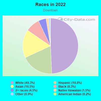
- 2,50049.3%White
- 95418.8%Hispanic or Latino
- 83516.5%Asian
- 4218.3%Black
- 2274.5%Two or more races
- 761.5%Native Hawaiian and Other
Pacific Islander - 450.9%Some other race
- 110.2%American Indian
Distribution of median household income
![Distribution of median household income]()
- 311Less than $10,000
- 1,428$10,000 to $19,999
- 160$20,000 to $29,999
- 113$30,000 to $39,999
- 320$40,000 to $49,999
- 184$50,000 to $59,999
- 72$60,000 to $74,999
- 212$75,000 to $99,999
- 230$100,000 to $124,999
- 121$125,000 to $149,999
- 198$150,000 to $199,999
- 542$200,000 or more

Distribution of owner-occupied house/condo value
![Distribution of owner-occupied house/condo value]()
- 167Less than $50,000
- 167$50,000 to $99,999
- 141$100,000 to $149,999
- 451$150,000 to $199,999
- 80$200,000 to $249,999
- 70$250,000 to $299,999
- 51$300,000 to $399,999
- 150$400,000 to $499,999
- 302$500,000 to $749,999
- 46$750,000 to $999,999
- 473$1,000,000 or more

Distribution of rent paid by renters
![Distribution of rent paid by renters]()
- 63Less than $100
- 682$100 to $199
- 1,455$200 to $299
- 168$300 to $399
- 79$400 to $499
- 378$500 to $599
- 542$600 to $699
- 131$700 to $799
- 152$800 to $899
- 71$900 to $999
- 198$1,000 to $1,249
- 67$1,250 to $1,499
- 490$1,500 to $1,999
- 1,037$2,000 or more

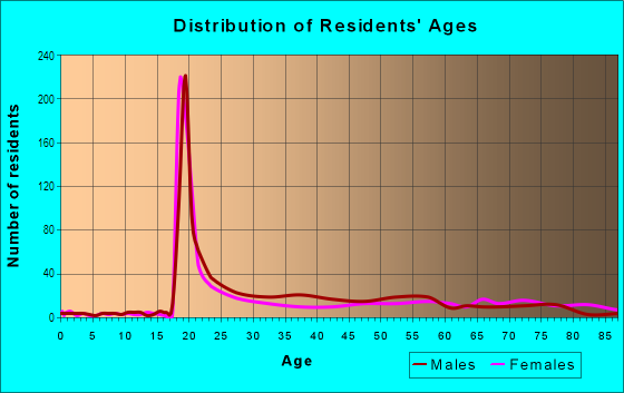
| Males: | 2,084 |
| Females: | 2,811 |
Males:
| This neighborhood: | 33.0 years |
| Whole city: | 32.9 years |
| This neighborhood: | 32.0 years |
| Whole city: | 32.4 years |
Average household size:
| Downtown: | 4.0 people |
| Providence: | 2.4 people |
Percentage of family households:
| Downtown: | 13.5% |
| Providence: | 37.9% |
| Here: | 13.5% |
| Providence: | 27.6% |
Percentage of married-couple families with children (among all households):
| Downtown: | 62.7% |
| Providence: | 17.7% |
Percentage of single-mother households (among all households):
| Downtown: | 35.8% |
| Providence: | 10.3% |
Percentage of never married males 15 years old and over:
Percentage of never married females 15 years old and over:
| Downtown: | 29.9% |
| Providence: | 26.8% |
Percentage of never married females 15 years old and over:
| Downtown: | 40.6% |
| city: | 28.2% |
Percentage of people that speak English not well or not at all:
| Downtown: | 7.5% |
| Providence: | 11.5% |
Percentage of people born in this state:
Percentage of people born in another U.S. state:
Percentage of native residents but born outside the U.S.:
Percentage of foreign born residents:
| Here: | 21.2% |
| Providence: | 30.5% |
Percentage of people born in another U.S. state:
| Downtown: | 45.4% |
| Providence: | 31.3% |
Percentage of native residents but born outside the U.S.:
| Here: | 4.5% |
| city: | 4.9% |
Percentage of foreign born residents:
| Here: | 28.9% |
| Providence: | 33.4% |
Owner-occupied
Renter-occupied

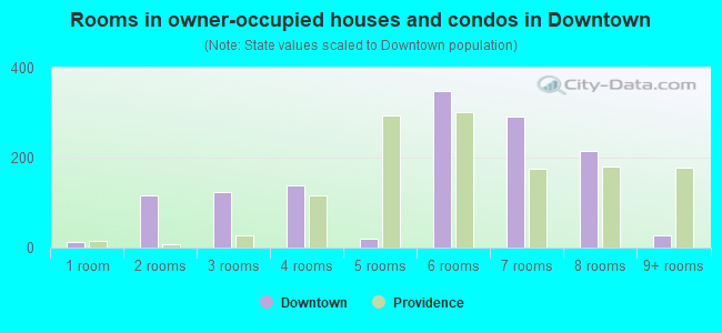
- Rooms in owner-occupied houses and condos in Downtown
- 121 room
- 1162 rooms
- 1243 rooms
- 1384 rooms
- 205 rooms
- 3486 rooms
- 2917 rooms
- 2168 rooms
- 279+ rooms
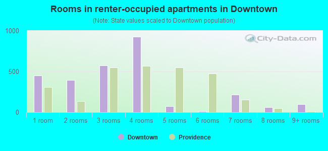
- Rooms in renter-occupied apartments in Downtown
- 4531 room
- 3952 rooms
- 5723 rooms
- 9284 rooms
- 715 rooms
- 156 rooms
- 2187 rooms
- 608 rooms
- 979+ rooms
Owner-occupied
Renter-occupied
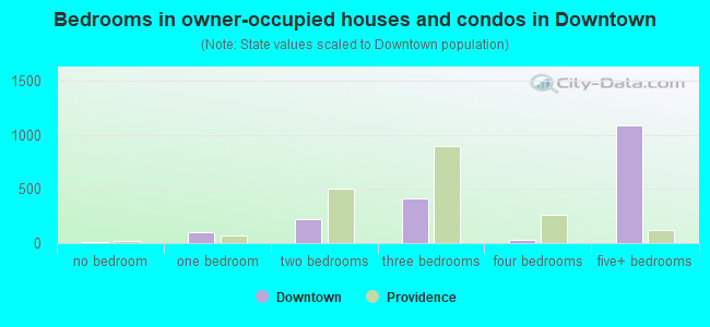
- Bedrooms in owner-occupied houses and condos in Downtown
- 12no bedroom
- 1041 bedroom
- 2182 bedrooms
- 4153 bedrooms
- 284 bedrooms
- 1,0905+ bedrooms
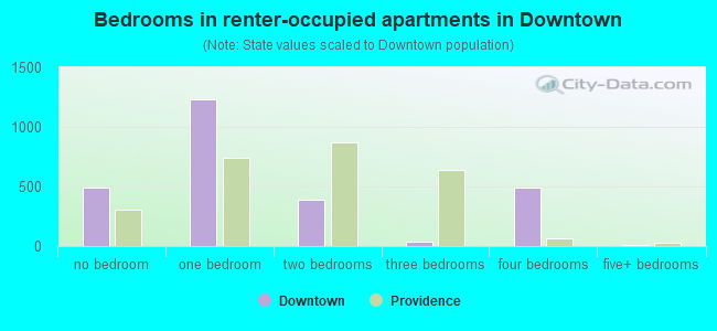
- Bedrooms in renter-occupied apartments in Downtown
- 489no bedroom
- 1,2331 bedroom
- 3912 bedrooms
- 333 bedrooms
- 4944 bedrooms
- 115+ bedrooms
Average number of cars or other vehicles available in houses/condos:
Average number of cars or other vehicles available in apartments:
| This neighborhood: | |
| Providence: |
Average number of cars or other vehicles available in apartments:
| Here: | 0.5 |
| city: | 1.0 |
Percentage of units with a mortgage:
| Downtown: | 71.7% |
| Providence: | 69.1% |
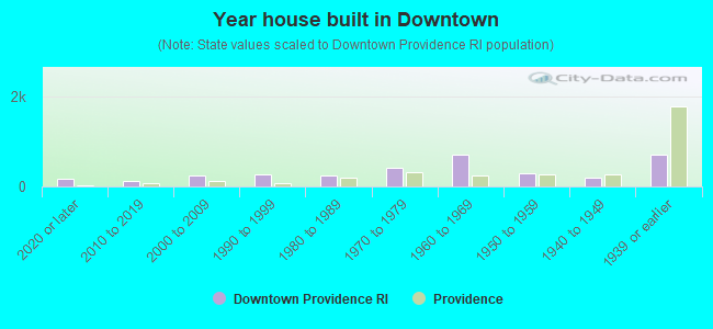
- Year house built in Downtown
- 1632020 or later
- 1252010 to 2019
- 2412000 to 2009
- 2621990 to 1999
- 2511980 to 1989
- 4131970 to 1979
- 7001960 to 1969
- 2801950 to 1959
- 2031940 to 1949
- 7081939 or earlier
City-data.com crime index for city in 2020 (higher means more crime):
| City: | 265.3 |
| U.S. average: | 219.5 |
Travel time to work (commute)
![Travel time to work (commute)]()
- 100Less than 5 minutes
- 3455 to 9 minutes
- 41310 to 14 minutes
- 47915 to 19 minutes
- 15520 to 24 minutes
- 5425 to 29 minutes
- 23130 to 34 minutes
- 3235 to 39 minutes
- 6440 to 44 minutes
- 7145 to 59 minutes
- 3860 to 89 minutes
- 7090 or more minutes

Means of transportation to work
![Means of transportation to work]()
- 45.0%1,049Drove a car alone
- 4.5%104Carpooled
- 8.5%198Bus
- 3.4%80Subway or elevated rail
- 1.2%27Long-distance train or commuter rail
- 5.8%135Taxi
- 15.4%358Bicycle
- 25.9%605Walked
- 3.0%70Other means
- 18.1%422Worked at home

Time leaving home to go to work
![Time leaving home to go to work]()
- 5812:00 a.m. to 4:59 a.m.
- 505:00 a.m. to 5:29 a.m.
- 175:30 a.m. to 5:59 a.m.
- 1226:00 a.m. to 6:29 a.m.
- 1176:30 a.m. to 6:59 a.m.
- 1417:00 a.m. to 7:29 a.m.
- 3377:30 a.m. to 7:59 a.m.
- 1578:00 a.m. to 8:29 a.m.
- 2788:30 a.m. to 8:59 a.m.
- 2649:00 a.m. to 9:59 a.m.
- 11510:00 a.m. to 10:59 a.m.
- 7511:00 a.m. to 11:59 a.m.
- 14312:00 p.m. to 3:59 p.m.
- 2224:00 p.m. to 11:59 p.m.

Occupations of males:
- Percentage of males in management occupations (except farmers):
Here: 16.3% city: 8.8%
- Percentage of males in business and financial operations occupations:
Here: 3.7% city: 3.9%
- Percentage of males in computer and mathematical occupations:
Here: 20.3% city: 4.7%
- Percentage of males in architecture and engineering occupations:
Here: 2.7% city: 2.5%
- Percentage of males in legal occupations:
Here: 1.5% city: 0.9%
- Percentage of males in education, training, and library occupations:
Here: 10.1% city: 7.3%
- Percentage of males in arts, design, entertainment, sports, and media occupations:
Here: 3.6% city: 3.0%
- Percentage of males in healthcare practitioners and technical occupations:
Here: 14.9% city: 4.3%
- Percentage of males in service occupations:
Here: 8.9% city: 15.1%
- Percentage of males in sales and office occupations:
Here: 13.0% city: 14.9%
- Percentage of males in construction, extraction, and maintenance occupations:
Here: 2.4% city: 6.4%
Occupations of females:
- Percentage of females in management occupations (except farmers):
Here: 6.3% city: 8.1%
- Percentage of females in business and financial operations occupations:
Here: 13.4% city: 4.1%
- Percentage of females in architecture and engineering occupations:
Here: 9.0% city: 1.2%
- Percentage of females in community and social services occupations:
Here: 3.0% city: 2.9%
- Percentage of females in legal occupations:
Here: 3.4% city: 1.4%
- Percentage of females in education, training, and library occupations:
Here: 10.5% city: 9.3%
- Percentage of females in arts, design, entertainment, sports, and media occupations:
Here: 8.5% city: 3.3%
- Percentage of females in healthcare practitioners and technical occupations:
Here: 13.9% city: 7.1%
- Percentage of females in service occupations:
Here: 17.4% city: 26.3%
- Percentage of females in sales and office occupations:
Here: 12.0% city: 21.8%
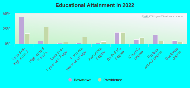
Education in this neighborhood (subdivision or community):
- Percentage of people 3 years and older in K-12 schools:
Downtown: 49.2% Providence: 17.2%
- Percentage of people 3 years and older in undergraduate colleges:
Downtown: 34.3% Providence: 11.1%
- Percentage of people 3 years and older in grad. or professional schools:
Downtown: 7.2% Providence: 3.3%
- Percentage of students K-12 enrolled in private schools:
Downtown: 105.8% Providence: 13.0%
Percentage of population below poverty level:
| Downtown: | 24.4% |
| Providence: | 21.0% |
Percentage of married-couple families with both working:
| Downtown: | 122.6% |
| Providence: | 66.2% |
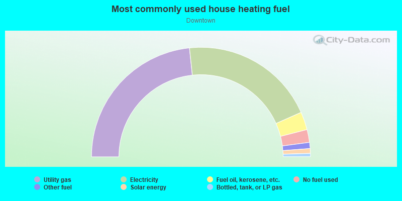
- 46.7%Utility gas
- 40.1%Electricity
- 5.3%Fuel oil, kerosene, etc.
- 3.8%No fuel used
- 1.8%Other fuel
- 1.4%Solar energy
- 1.0%Bottled, tank, or LP gas
Limited-access highways (interstate or state) in this neighborhood:
US Hwy 6 (I- 195)
Length: 1.01 miles
Directions: E-W, SW-NE
Directions: E-W, SW-NE
I- 95
Length: 0.43 miles
Directions: N-S, SE-NW
Directions: N-S, SE-NW
Highways in this neighborhood:
Memorial Blvd (US Hwy 44)
Length: 1.61 miles
Directions: E-W, N-S, SE-NW
Directions: E-W, N-S, SE-NW
US Hwy 6
Length: 0.58 miles
Directions: E-W, SE-NW, SW-NE
Directions: E-W, SE-NW, SW-NE
Fountain St (US Hwy 1)
Length: 0.51 miles
Directions: E-W, N-S, SE-NW, SW-NE
Address range: 214 to 239
Directions: E-W, N-S, SE-NW, SW-NE
Address range: 214 to 239
US Hwy 1 (Empire St)
Length: 0.33 miles
Directions: N-S, SE-NW, SW-NE
Address range: 1 to 130
Directions: N-S, SE-NW, SW-NE
Address range: 1 to 130
Canal St (US Hwy 44)
Length: 0.32 miles
Directions: N-S, SE-NW
Address range: 112 to 399
Directions: N-S, SE-NW
Address range: 112 to 399
US Hwy 44 (S Water St)
Length: 0.31 miles
Directions: E-W, N-S, SE-NW
Address range: 22 to 212
Directions: E-W, N-S, SE-NW
Address range: 22 to 212
Allens Ave (US Hwy 1 Alt)
Length: 0.29 miles
Directions: N-S, SE-NW
Address range: 2 to 18
Directions: N-S, SE-NW
Address range: 2 to 18
Gaspee St (US Hwy 1)
Length: 0.28 miles
Directions: E-W, N-S, SW-NE
Address range: 13 to 199
Directions: E-W, N-S, SW-NE
Address range: 13 to 199
S Main St (US Hwy 44)
Length: 0.27 miles
Directions: N-S, SE-NW
Address range: 1 to 226
Directions: N-S, SE-NW
Address range: 1 to 226
US Hwy 44 (N Main St)
Length: 0.24 miles
Directions: N-S, SE-NW
Address range: 1 to 129
Directions: N-S, SE-NW
Address range: 1 to 129
Sabin St (US Hwy 1)
Length: 0.19 miles
Direction: SW-NE
Direction: SW-NE
Smith St (US Hwy 44, US Hwy 1)
Length: 0.10 miles
Direction: E-W
Address range: 26 to 98
Direction: E-W
Address range: 26 to 98
Roads and streets:
Eddy St
Length: 1.10 miles
Directions: N-S, SE-NW
Address range: 14 to 614
Directions: N-S, SE-NW
Address range: 14 to 614
Westminster St
Length: 0.74 miles
Directions: E-W, N-S, SW-NE
Address range: 7 to 623
Directions: E-W, N-S, SW-NE
Address range: 7 to 623
Point St
Length: 0.69 miles
Directions: E-W, SW-NE
Address range: 71 to 196
Directions: E-W, SW-NE
Address range: 71 to 196
Pine St
Length: 0.69 miles
Directions: E-W, SW-NE
Address range: 4 to 299
Directions: E-W, SW-NE
Address range: 4 to 299
Richmond St
Length: 0.58 miles
Directions: E-W, SE-NW
Address range: 1 to 499
Directions: E-W, SE-NW
Address range: 1 to 499
Washington St
Length: 0.53 miles
Direction: SW-NE
Address range: 1 to 293
Direction: SW-NE
Address range: 1 to 293
Dorrance St
Length: 0.53 miles
Directions: E-W, N-S, SE-NW, SW-NE
Address range: 2 to 181
Directions: E-W, N-S, SE-NW, SW-NE
Address range: 2 to 181
Chestnut St
Length: 0.52 miles
Direction: SE-NW
Address range: 1 to 299
Direction: SE-NW
Address range: 1 to 299
Kennedy Plz
Length: 0.50 miles
Directions: E-W, SW-NE
Address range: 1 to 99
Directions: E-W, SW-NE
Address range: 1 to 99
South St
Length: 0.49 miles
Directions: E-W, SW-NE
Address range: 1 to 199
Directions: E-W, SW-NE
Address range: 1 to 199
Francis St
Length: 0.49 miles
Directions: E-W, N-S, SE-NW, SW-NE
Address range: 1 to 122
Directions: E-W, N-S, SE-NW, SW-NE
Address range: 1 to 122
Weybosset St
Length: 0.47 miles
Directions: E-W, N-S, SE-NW, SW-NE
Address range: 1 to 337
Directions: E-W, N-S, SE-NW, SW-NE
Address range: 1 to 337
Franklin St
Length: 0.45 miles
Directions: E-W, N-S, SE-NW
Address range: 1 to 92
Directions: E-W, N-S, SE-NW
Address range: 1 to 92
Clifford St
Length: 0.39 miles
Direction: SW-NE
Address range: 1 to 199
Direction: SW-NE
Address range: 1 to 199
Friendship St
Length: 0.38 miles
Direction: SW-NE
Address range: 3 to 284
Direction: SW-NE
Address range: 3 to 284
Exchange Ter
Length: 0.37 miles
Directions: E-W, SW-NE
Address range: 1 to 99
Directions: E-W, SW-NE
Address range: 1 to 99
Hospital St
Length: 0.36 miles
Direction: SE-NW
Address range: 1 to 136
Direction: SE-NW
Address range: 1 to 136
Broadway
Length: 0.36 miles
Directions: E-W, SW-NE
Directions: E-W, SW-NE
Greene St
Length: 0.33 miles
Direction: SE-NW
Address range: 1 to 99
Direction: SE-NW
Address range: 1 to 99
Mathewson St
Length: 0.31 miles
Directions: N-S, SE-NW, SW-NE
Address range: 58 to 203
Directions: N-S, SE-NW, SW-NE
Address range: 58 to 203
W Exchange St
Length: 0.31 miles
Direction: E-W
Address range: 57 to 163
Direction: E-W
Address range: 57 to 163
Elm St
Length: 0.29 miles
Directions: E-W, SW-NE
Address range: 1 to 118
Directions: E-W, SW-NE
Address range: 1 to 118
Dyer St
Length: 0.29 miles
Directions: N-S, SW-NE
Address range: 62 to 231
Directions: N-S, SW-NE
Address range: 62 to 231
Ship St
Length: 0.28 miles
Directions: E-W, SE-NW
Address range: 1 to 99
Directions: E-W, SE-NW
Address range: 1 to 99
Clemence St
Length: 0.27 miles
Direction: SE-NW
Address range: 1 to 107
Direction: SE-NW
Address range: 1 to 107
Snow St
Length: 0.27 miles
Direction: SE-NW
Address range: 1 to 145
Direction: SE-NW
Address range: 1 to 145
Union St
Length: 0.26 miles
Direction: SE-NW
Address range: 1 to 299
Direction: SE-NW
Address range: 1 to 299
Orange St
Length: 0.24 miles
Direction: SE-NW
Address range: 1 to 175
Direction: SE-NW
Address range: 1 to 175
Dyer (Dyer St)
Length: 0.23 miles
Directions: E-W, N-S, SE-NW, SW-NE
Address range: 103 to 121
Directions: E-W, N-S, SE-NW, SW-NE
Address range: 103 to 121
Henderson St
Length: 0.23 miles
Direction: E-W
Address range: 1 to 199
Direction: E-W
Address range: 1 to 199
Broad St
Length: 0.23 miles
Direction: SW-NE
Address range: 1 to 115
Direction: SW-NE
Address range: 1 to 115
Bassett St
Length: 0.22 miles
Directions: N-S, SW-NE
Address range: 1 to 99
Directions: N-S, SW-NE
Address range: 1 to 99
Exchange St
Length: 0.21 miles
Direction: SE-NW
Direction: SE-NW
Aborn St
Length: 0.21 miles
Direction: SE-NW
Address range: 1 to 299
Direction: SE-NW
Address range: 1 to 299
Globe St
Length: 0.21 miles
Direction: E-W
Address range: 1 to 160
Direction: E-W
Address range: 1 to 160
Park Row W
Length: 0.20 miles
Directions: E-W, SE-NW, SW-NE
Address range: 3 to 99
Directions: E-W, SE-NW, SW-NE
Address range: 3 to 99
Parsonage St
Length: 0.19 miles
Direction: SE-NW
Address range: 1 to 82
Direction: SE-NW
Address range: 1 to 82
Hoppin St
Length: 0.19 miles
Directions: N-S, SE-NW, SW-NE
Address range: 3 to 199
Directions: N-S, SE-NW, SW-NE
Address range: 3 to 199
Park St
Length: 0.18 miles
Direction: N-S
Address range: 1 to 63
Direction: N-S
Address range: 1 to 63
Crary St
Length: 0.18 miles
Directions: E-W, SE-NW
Address range: 1 to 107
Directions: E-W, SE-NW
Address range: 1 to 107
American Express Plz
Length: 0.17 miles
Directions: E-W, SW-NE
Address range: 1 to 99
Directions: E-W, SW-NE
Address range: 1 to 99
Peck St
Length: 0.16 miles
Directions: E-W, SE-NW
Address range: 1 to 75
Directions: E-W, SE-NW
Address range: 1 to 75
Canal Walk
Length: 0.16 miles
Directions: E-W, SE-NW
Address range: 1 to 111
Directions: E-W, SE-NW
Address range: 1 to 111
Claverick St
Length: 0.16 miles
Direction: SE-NW
Address range: 1 to 63
Direction: SE-NW
Address range: 1 to 63
Chapel St
Length: 0.14 miles
Direction: SW-NE
Address range: 1 to 63
Direction: SW-NE
Address range: 1 to 63
Elbow St
Length: 0.14 miles
Directions: N-S, SW-NE
Address range: 1 to 50
Directions: N-S, SW-NE
Address range: 1 to 50
Garnet St
Length: 0.14 miles
Direction: E-W
Address range: 1 to 47
Direction: E-W
Address range: 1 to 47
Page St
Length: 0.14 miles
Direction: E-W
Address range: 1 to 66
Direction: E-W
Address range: 1 to 66
Middle St
Length: 0.14 miles
Direction: SW-NE
Address range: 1 to 99
Direction: SW-NE
Address range: 1 to 99
Atwells Ave
Length: 0.13 miles
Directions: E-W, N-S, SE-NW
Address range: 1 to 80
Directions: E-W, N-S, SE-NW
Address range: 1 to 80
Manchester Pl
Length: 0.13 miles
Directions: E-W, N-S, SE-NW
Address range: 1 to 80
Directions: E-W, N-S, SE-NW
Address range: 1 to 80
Hayes St
Length: 0.13 miles
Directions: E-W, SW-NE
Address range: 1 to 99
Directions: E-W, SW-NE
Address range: 1 to 99
Read St
Length: 0.13 miles
Directions: E-W, SW-NE
Address range: 1 to 31
Directions: E-W, SW-NE
Address range: 1 to 31
Railroad St
Length: 0.12 miles
Directions: E-W, N-S, SE-NW, SW-NE
Directions: E-W, N-S, SE-NW, SW-NE
Winslow St (Winslow)
Length: 0.12 miles
Direction: SE-NW
Direction: SE-NW
Cookson Pl
Length: 0.11 miles
Direction: SE-NW
Address range: 1 to 86
Direction: SE-NW
Address range: 1 to 86
Jackson Walkway
Length: 0.11 miles
Directions: SE-NW, SW-NE
Address range: 1 to 81
Directions: SE-NW, SW-NE
Address range: 1 to 81
Fenner St
Length: 0.10 miles
Directions: N-S, SE-NW
Address range: 20 to 59
Directions: N-S, SE-NW
Address range: 20 to 59
Fulton St
Length: 0.10 miles
Direction: SW-NE
Address range: 1 to 43
Direction: SW-NE
Address range: 1 to 43
Foster St
Length: 0.10 miles
Direction: SE-NW
Address range: 1 to 21
Direction: SE-NW
Address range: 1 to 21
Imperial Pl
Length: 0.10 miles
Direction: SE-NW
Address range: 1 to 99
Direction: SE-NW
Address range: 1 to 99
Walnut St
Length: 0.10 miles
Direction: SE-NW
Address range: 1 to 31
Direction: SE-NW
Address range: 1 to 31
Stillman St
Length: 0.09 miles
Direction: SW-NE
Direction: SW-NE
Promenade (Promenade St)
Length: 0.09 miles
Direction: E-W
Address range: 1 to 150
Direction: E-W
Address range: 1 to 150
Custom House St
Length: 0.09 miles
Direction: E-W
Address range: 1 to 65
Direction: E-W
Address range: 1 to 65
Worchester St
Length: 0.08 miles
Direction: SW-NE
Address range: 8 to 69
Direction: SW-NE
Address range: 8 to 69
Moshassuck Ct
Length: 0.08 miles
Direction: SE-NW
Direction: SE-NW
Tallman (Tallman St)
Length: 0.08 miles
Directions: E-W, SW-NE
Directions: E-W, SW-NE
Park Row
Length: 0.07 miles
Direction: E-W
Address range: 1 to 99
Direction: E-W
Address range: 1 to 99
Post Office Ct
Length: 0.07 miles
Direction: E-W
Address range: 1 to 49
Direction: E-W
Address range: 1 to 49
Moulton Ln
Length: 0.07 miles
Direction: SE-NW
Address range: 1 to 25
Direction: SE-NW
Address range: 1 to 25
College St
Length: 0.07 miles
Directions: E-W, SW-NE
Directions: E-W, SW-NE
Crawford St
Length: 0.07 miles
Direction: E-W
Address range: 42 to 65
Direction: E-W
Address range: 42 to 65
Throop Aly
Length: 0.07 miles
Direction: E-W
Address range: 1 to 99
Direction: E-W
Address range: 1 to 99
Adrian Hill Way
Length: 0.07 miles
Directions: E-W, SE-NW
Address range: 48 to 299
Directions: E-W, SE-NW
Address range: 48 to 299
la Salle Sq
Length: 0.07 miles
Direction: E-W
Address range: 68 to 99
Direction: E-W
Address range: 68 to 99
Blair Ln
Length: 0.07 miles
Direction: E-W
Address range: 1 to 27
Direction: E-W
Address range: 1 to 27
Steeple St
Length: 0.06 miles
Direction: E-W
Address range: 1 to 18
Direction: E-W
Address range: 1 to 18
Arcade St
Length: 0.06 miles
Direction: SE-NW
Address range: 1 to 49
Direction: SE-NW
Address range: 1 to 49
Marengo St
Length: 0.06 miles
Direction: E-W
Direction: E-W
Washington Pl
Length: 0.06 miles
Directions: E-W, SW-NE
Address range: 1 to 31
Directions: E-W, SW-NE
Address range: 1 to 31
Power St
Length: 0.06 miles
Directions: E-W, SW-NE
Address range: 2 to 14
Directions: E-W, SW-NE
Address range: 2 to 14
Hay St
Length: 0.05 miles
Direction: SE-NW
Address range: 22 to 49
Direction: SE-NW
Address range: 22 to 49
Martha St
Length: 0.05 miles
Direction: SW-NE
Address range: 1 to 67
Direction: SW-NE
Address range: 1 to 67
Bullion St
Length: 0.05 miles
Direction: SW-NE
Address range: 1 to 26
Direction: SW-NE
Address range: 1 to 26
Delta St
Length: 0.05 miles
Direction: SE-NW
Address range: 1 to 23
Direction: SE-NW
Address range: 1 to 23
Lake St
Length: 0.05 miles
Direction: E-W
Direction: E-W
Wirt St
Length: 0.05 miles
Direction: N-S
Address range: 1 to 19
Direction: N-S
Address range: 1 to 19
Marengo St (Marengo)
Length: 0.05 miles
Direction: E-W
Direction: E-W
Planet St
Length: 0.05 miles
Direction: SW-NE
Address range: 1 to 10
Direction: SW-NE
Address range: 1 to 10
Amos St
Length: 0.05 miles
Direction: E-W
Address range: 1 to 49
Direction: E-W
Address range: 1 to 49
Cathedral Sq
Length: 0.05 miles
Directions: E-W, SE-NW
Address range: 1 to 99
Directions: E-W, SE-NW
Address range: 1 to 99
Packet St
Length: 0.05 miles
Direction: SW-NE
Address range: 1 to 26
Direction: SW-NE
Address range: 1 to 26
Clifford (Clifford St)
Length: 0.05 miles
Direction: SW-NE
Direction: SW-NE
Drowne St
Length: 0.04 miles
Direction: SW-NE
Address range: 1 to 49
Direction: SW-NE
Address range: 1 to 49
Pond St
Length: 0.04 miles
Direction: SW-NE
Address range: 1 to 55
Direction: SW-NE
Address range: 1 to 55
Francis (Francis St)
Length: 0.04 miles
Directions: E-W, SE-NW
Directions: E-W, SE-NW
Maiden Ln
Length: 0.03 miles
Direction: SW-NE
Address range: 1 to 49
Direction: SW-NE
Address range: 1 to 49
Jerry
Length: 0.03 miles
Directions: N-S, SW-NE
Address range: 1 to 49
Directions: N-S, SW-NE
Address range: 1 to 49
Kinsley Ave (Providence Pl)
Length: 0.03 miles
Directions: E-W, N-S, SW-NE
Address range: 1 to 73
Directions: E-W, N-S, SW-NE
Address range: 1 to 73
Turks Head Pl
Length: 0.03 miles
Direction: SE-NW
Address range: 1 to 101
Direction: SE-NW
Address range: 1 to 101
Claverick St (Claverick)
Length: 0.02 miles
Direction: SE-NW
Direction: SE-NW
Weybosset St (Weybosset)
Length: 0.02 miles
Directions: N-S, SW-NE
Address range: 190 to 201
Directions: N-S, SW-NE
Address range: 190 to 201
Promenade St
Length: 0.02 miles
Direction: E-W
Direction: E-W
Railroad features:
Amtrak
Length: 2.20 miles
Directions: E-W, N-S, SW-NE
Directions: E-W, N-S, SW-NE
New York New Haven and Hartford RR
Length: 0.52 miles
Directions: E-W, N-S, SW-NE
Directions: E-W, N-S, SW-NE