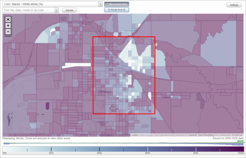
Freedom neighborhood in Alliance, Ohio (OH), 44601 detailed profile
Settings
X

Business Search - 14 Million verified businesses
Area: 2.281 square miles
Population: 8,189
Population density:
| Freedom: | 3,590 people per square mile |
| Alliance: | 2,509 people per square mile |

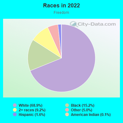
- 6,12468.9%White
- 1,34815.2%Black
- 8189.2%Two or more races
- 4405.0%Some other race
- 1421.6%Hispanic or Latino
- 100.1%American Indian
- 40.05%Asian
Distribution of median household income
![Distribution of median household income]()
- 333Less than $10,000
- 717$10,000 to $19,999
- 710$20,000 to $29,999
- 371$30,000 to $39,999
- 445$40,000 to $49,999
- 327$50,000 to $59,999
- 532$60,000 to $74,999
- 388$75,000 to $99,999
- 187$100,000 to $124,999
- 107$125,000 to $149,999
- 96$150,000 to $199,999
- 44$200,000 or more

Distribution of owner-occupied house/condo value
![Distribution of owner-occupied house/condo value]()
- 1,362Less than $50,000
- 1,325$50,000 to $99,999
- 319$100,000 to $149,999
- 115$150,000 to $199,999
- 113$200,000 to $249,999
- 25$250,000 to $299,999
- 2$300,000 to $399,999
- 5$400,000 to $499,999
- 159$500,000 to $749,999
- 38$750,000 to $999,999
- 19$1,000,000 or more

Distribution of rent paid by renters
![Distribution of rent paid by renters]()
- 40Less than $100
- 231$100 to $199
- 548$200 to $299
- 698$300 to $399
- 556$400 to $499
- 727$500 to $599
- 594$600 to $699
- 244$700 to $799
- 86$800 to $899
- 306$900 to $999
- 188$1,000 to $1,249
- 28$1,500 to $1,999

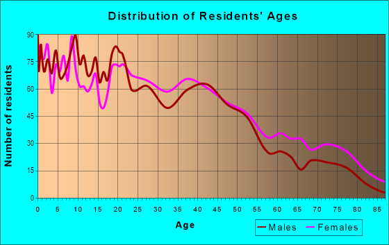
| Males: | 4,251 |
| Females: | 3,937 |
Males:
| This neighborhood: | 35.8 years |
| Whole city: | 33.6 years |
| This neighborhood: | 39.2 years |
| Whole city: | 40.1 years |
Average household size:
| Freedom: | 5.4 people |
| Alliance: | 2.4 people |
Percentage of family households:
| Freedom: | 47.1% |
| Alliance: | 41.1% |
| Here: | 26.1% |
| Alliance: | 33.5% |
Percentage of married-couple families with children (among all households):
| Freedom: | 17.5% |
| Alliance: | 19.4% |
Percentage of single-mother households (among all households):
| Freedom: | 20.3% |
| Alliance: | 15.4% |
Percentage of never married males 15 years old and over:
Percentage of never married females 15 years old and over:
| Freedom: | 26.2% |
| Alliance: | 23.0% |
Percentage of never married females 15 years old and over:
| Freedom: | 18.2% |
| city: | 17.9% |
Percentage of people that speak English not well or not at all:
| Freedom: | 0.0% |
| Alliance: | 0.0% |
Percentage of people born in this state:
Percentage of people born in another U.S. state:
Percentage of native residents but born outside the U.S.:
Percentage of foreign born residents:
| Here: | 86.9% |
| Alliance: | 87.6% |
Percentage of people born in another U.S. state:
| Freedom: | 12.2% |
| Alliance: | 11.0% |
Percentage of native residents but born outside the U.S.:
| Here: | 0.5% |
| city: | 0.5% |
Percentage of foreign born residents:
| Here: | 0.8% |
| Alliance: | 0.9% |
Owner-occupied
Renter-occupied

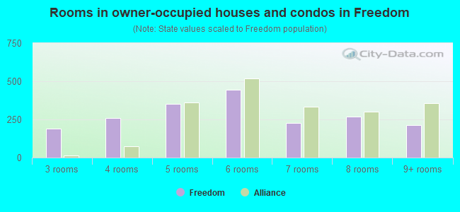
- Rooms in owner-occupied houses and condos in Freedom
- 01 room
- 02 rooms
- 1923 rooms
- 2574 rooms
- 3545 rooms
- 4466 rooms
- 2297 rooms
- 2678 rooms
- 2119+ rooms
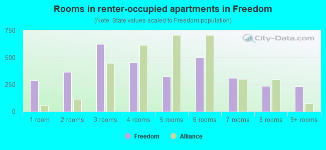
- Rooms in renter-occupied apartments in Freedom
- 2871 room
- 3662 rooms
- 6273 rooms
- 4524 rooms
- 3245 rooms
- 5006 rooms
- 3097 rooms
- 2348 rooms
- 2309+ rooms
Owner-occupied
Renter-occupied
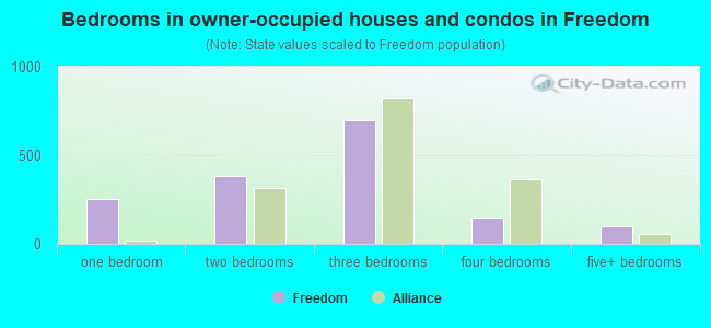
- Bedrooms in owner-occupied houses and condos in Freedom
- 0no bedroom
- 2561 bedroom
- 3812 bedrooms
- 6993 bedrooms
- 1474 bedrooms
- 985+ bedrooms
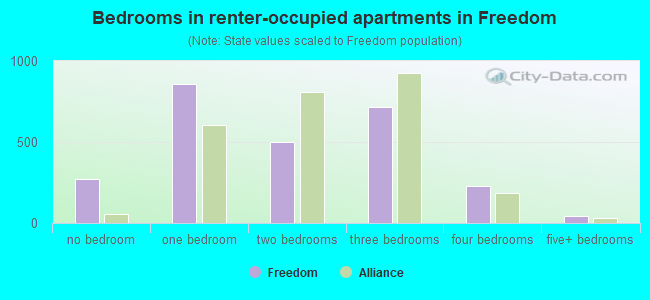
- Bedrooms in renter-occupied apartments in Freedom
- 270no bedroom
- 8591 bedroom
- 5022 bedrooms
- 7143 bedrooms
- 2304 bedrooms
- 435+ bedrooms
Average number of cars or other vehicles available in houses/condos:
Average number of cars or other vehicles available in apartments:
| This neighborhood: | 1.8 |
| Alliance: | 1.9 |
Average number of cars or other vehicles available in apartments:
| Here: | 1.2 |
| city: | 1.3 |
Percentage of units with a mortgage:
| Freedom: | 55.4% |
| Alliance: | 54.7% |
Average estimated value of detached houses in 2022 (61.4% of all units):
| Freedom: | $59,020 |
| Ohio: | $254,366 |
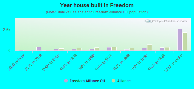
- Year house built in Freedom
- 722020 or later
- 4312010 to 2019
- 1812000 to 2009
- 2001990 to 1999
- 2261980 to 1989
- 3751970 to 1979
- 1321960 to 1969
- 3351950 to 1959
- 3691940 to 1949
- 2,5831939 or earlier
City-data.com crime index for city in 2020 (higher means more crime):
| City: | 192.2 |
| U.S. average: | 219.5 |
Travel time to work (commute)
![Travel time to work (commute)]()
- 179Less than 5 minutes
- 6235 to 9 minutes
- 28010 to 14 minutes
- 24715 to 19 minutes
- 25620 to 24 minutes
- 19625 to 29 minutes
- 32130 to 34 minutes
- 10535 to 39 minutes
- 6540 to 44 minutes
- 28245 to 59 minutes
- 5660 to 89 minutes
- 9390 or more minutes

Means of transportation to work
![Means of transportation to work]()
- 68.2%2,486Drove a car alone
- 17.9%653Carpooled
- 6.3%228Bus
- 2.0%72Taxi
- 2.8%101Bicycle
- 9.2%334Walked
- 11.2%409Other means
- 6.1%224Worked at home

Time leaving home to go to work
![Time leaving home to go to work]()
- 22012:00 a.m. to 4:59 a.m.
- 1245:00 a.m. to 5:29 a.m.
- 2045:30 a.m. to 5:59 a.m.
- 1826:00 a.m. to 6:29 a.m.
- 2366:30 a.m. to 6:59 a.m.
- 2327:00 a.m. to 7:29 a.m.
- 2197:30 a.m. to 7:59 a.m.
- 1808:00 a.m. to 8:29 a.m.
- 1198:30 a.m. to 8:59 a.m.
- 849:00 a.m. to 9:59 a.m.
- 6110:00 a.m. to 10:59 a.m.
- 1511:00 a.m. to 11:59 a.m.
- 50212:00 p.m. to 3:59 p.m.
- 2324:00 p.m. to 11:59 p.m.

Occupations of males:
- Percentage of males in management occupations (except farmers):
Here: 5.9% city: 6.7%
- Percentage of males in business and financial operations occupations:
Here: 1.6% city: 1.3%
- Percentage of males in computer and mathematical occupations:
Here: 1.2% city: 2.2%
- Percentage of males in community and social services occupations:
Here: 3.2% city: 1.7%
- Percentage of males in healthcare practitioners and technical occupations:
Here: 1.6% city: 2.4%
- Percentage of males in service occupations:
Here: 16.6% city: 14.3%
- Percentage of males in sales and office occupations:
Here: 9.0% city: 13.1%
- Percentage of males in construction, extraction, and maintenance occupations:
Here: 6.5% city: 6.8%
- Percentage of males in production occupations:
Here: 21.4% city: 21.1%
- Percentage of males in transportation occupations:
Here: 5.7% city: 3.2%
- Percentage of males in material moving occupations:
Here: 17.7% city: 13.3%
Occupations of females:
- Percentage of females in management occupations (except farmers):
Here: 7.8% city: 7.3%
- Percentage of females in business and financial operations occupations:
Here: 3.1% city: 3.4%
- Percentage of females in community and social services occupations:
Here: 5.4% city: 3.1%
- Percentage of females in legal occupations:
Here: 1.2% city: 1.1%
- Percentage of females in education, training, and library occupations:
Here: 6.1% city: 8.4%
- Percentage of females in healthcare practitioners and technical occupations:
Here: 10.8% city: 16.4%
- Percentage of females in service occupations:
Here: 31.2% city: 27.4%
- Percentage of females in sales and office occupations:
Here: 22.3% city: 23.4%
- Percentage of females in production occupations:
Here: 9.6% city: 5.4%
- Percentage of females in transportation occupations:
Here: 1.5% city: 1.2%
Percentage of people 16-64 in Armed Forces:
| Freedom: | 0.3% |
| Alliance: | 0.1% |
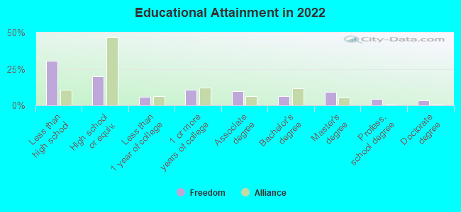
Education in this neighborhood (subdivision or community):
- Percentage of people 3 years and older in K-12 schools:
Freedom: 27.6% Alliance: 15.3%
- Percentage of people 3 years and older in undergraduate colleges:
Freedom: 9.0% Alliance: 8.8%
- Percentage of people 3 years and older in grad. or professional schools:
Freedom: 7.4% Alliance: 1.2%
- Percentage of students K-12 enrolled in private schools:
Freedom: 33.8% Alliance: 10.4%
Percentage of population below poverty level:
| Freedom: | 32.9% |
| Alliance: | 23.1% |
Median year owner moved in (as recorded in 2022):
Median year renter moved in (as recorded in 2022):
| Freedom: | 2001 |
| Alliance: | 2004 |
Median year renter moved in (as recorded in 2022):
| Freedom: | 2017 |
| Alliance: | 2017 |
Percentage of married-couple families with both working:
| Freedom: | 101.6% |
| Alliance: | 77.8% |
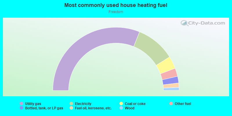
- 62.2%Utility gas
- 20.0%Electricity
- 6.4%Coal or coke
- 4.2%Other fuel
- 3.4%Bottled, tank, or LP gas
- 2.2%Fuel oil, kerosene, etc.
- 1.6%Wood
Roads and streets:
S Mahoning Ave
Length: 0.80 miles
Direction: N-S
Address range: 48 to 1259
Direction: N-S
Address range: 48 to 1259
N Mahoning Ave
Length: 0.40 miles
Direction: N-S
Address range: 20 to 820
Direction: N-S
Address range: 20 to 820
Stanley Ave
Length: 0.28 miles
Directions: N-S, SE-NW
Address range: 13412 to 13726
Directions: N-S, SE-NW
Address range: 13412 to 13726
Thompson St
Length: 0.18 miles
Direction: N-S
Address range: 13700 to 13999
Direction: N-S
Address range: 13700 to 13999
Railroad St
Length: 0.11 miles
Direction: E-W
Direction: E-W
Jersey St
Length: 0.09 miles
Direction: E-W
Direction: E-W
Alliance Sebring Rd
Length: 0.09 miles
Direction: E-W
Address range: 22828 to 22899
Direction: E-W
Address range: 22828 to 22899
Front St
Length: 0.09 miles
Direction: E-W
Address range: 15900 to 15953
Direction: E-W
Address range: 15900 to 15953
Noble St
Length: 0.09 miles
Directions: E-W, SE-NW
Directions: E-W, SE-NW
Auld St
Length: 0.07 miles
Direction: E-W
Direction: E-W
Co Rd 255 (W Norman Ave)
Length: 0.05 miles
Direction: E-W
Address range: 1500 to 1599
Direction: E-W
Address range: 1500 to 1599
W Alden Ave (Twp Hwy 291)
Length: 0.04 miles
Direction: E-W
Address range: 1500 to 1599
Direction: E-W
Address range: 1500 to 1599
Co Rd 268 (Lake Park Blvd)
Length: 0.04 miles
Direction: E-W
Address range: 22918 to 22999
Direction: E-W
Address range: 22918 to 22999
Railroad features:
Conrail RR
Length: 0.26 miles
Directions: E-W, SE-NW
Directions: E-W, SE-NW
Highways in this neighborhood:
S Union Ave (State Hwy 183)
Length: 0.91 miles
Direction: N-S
Address range: 1 to 1398
Direction: N-S
Address range: 1 to 1398
N Union Ave (State Hwy 183)
Length: 0.60 miles
Direction: N-S
Address range: 1 to 899
Direction: N-S
Address range: 1 to 899
State Hwy 183 (Diehl Ct)
Length: 0.11 miles
Direction: SE-NW
Address range: 780 to 899
Direction: SE-NW
Address range: 780 to 899
Roads and streets:
163 (Haines Ave)
Length: 1.43 miles
Direction: N-S
Address range: 1 to 1299
Direction: N-S
Address range: 1 to 1299
E Summit St
Length: 1.32 miles
Direction: E-W
Address range: 1 to 1499
Direction: E-W
Address range: 1 to 1499
E Broadway St (39)
Length: 1.32 miles
Direction: E-W
Address range: 1 to 1499
Direction: E-W
Address range: 1 to 1499
South St (178)
Length: 1.19 miles
Direction: E-W
Address range: 100 to 1499
Direction: E-W
Address range: 100 to 1499
E Columbia St (43)
Length: 1.16 miles
Directions: E-W, N-S, SW-NE
Address range: 1 to 799
Directions: E-W, N-S, SW-NE
Address range: 1 to 799
E Grant St (45)
Length: 1.06 miles
Direction: E-W
Address range: 1 to 1199
Direction: E-W
Address range: 1 to 1199
E Patterson St
Length: 1.01 miles
Direction: E-W
Address range: 200 to 1499
Direction: E-W
Address range: 200 to 1499
S Liberty Ave (164)
Length: 0.90 miles
Direction: N-S
Address range: 1 to 1331
Direction: N-S
Address range: 1 to 1331
S Arch Ave (162)
Length: 0.89 miles
Direction: N-S
Address range: 1 to 1349
Direction: N-S
Address range: 1 to 1349
E Cambridge St (40)
Length: 0.88 miles
Direction: E-W
Address range: 1 to 1499
Direction: E-W
Address range: 1 to 1499
52 (E Oxford St)
Length: 0.87 miles
Direction: E-W
Address range: 1 to 1499
Direction: E-W
Address range: 1 to 1499
S Seneca Ave (170)
Length: 0.85 miles
Direction: N-S
Address range: 1 to 1299
Direction: N-S
Address range: 1 to 1299
S Linden Ave (166)
Length: 0.85 miles
Direction: N-S
Address range: 1 to 1299
Direction: N-S
Address range: 1 to 1299
118 (Milner St)
Length: 0.84 miles
Direction: E-W
Address range: 1 to 899
Direction: E-W
Address range: 1 to 899
S Mahoning Ave
Length: 0.80 miles
Direction: N-S
Address range: 48 to 1259
Direction: N-S
Address range: 48 to 1259
172 (S Webb Ave)
Length: 0.79 miles
Directions: N-S, SE-NW
Address range: 1 to 1099
Directions: N-S, SE-NW
Address range: 1 to 1099
133 (Noble St)
Length: 0.75 miles
Direction: E-W
Address range: 600 to 1499
Direction: E-W
Address range: 600 to 1499
E High St (47)
Length: 0.74 miles
Direction: E-W
Address range: 1 to 1499
Direction: E-W
Address range: 1 to 1499
49 (E Main St)
Length: 0.71 miles
Direction: E-W
Address range: 1 to 899
Direction: E-W
Address range: 1 to 899
148 (Prospect St)
Length: 0.70 miles
Directions: E-W, SE-NW
Address range: 1 to 599
Directions: E-W, SE-NW
Address range: 1 to 599
78 (Garwood St)
Length: 0.67 miles
Directions: E-W, SW-NE
Address range: 400 to 1199
Directions: E-W, SW-NE
Address range: 400 to 1199
50 (E Market St)
Length: 0.66 miles
Direction: E-W
Address range: 1 to 699
Direction: E-W
Address range: 1 to 699
146 (Pike St)
Length: 0.66 miles
Direction: E-W
Address range: 700 to 1499
Direction: E-W
Address range: 700 to 1499
Auld St (9)
Length: 0.66 miles
Direction: E-W
Address range: 700 to 1499
Direction: E-W
Address range: 700 to 1499
Reed St (150)
Length: 0.66 miles
Direction: E-W
Address range: 700 to 1489
Direction: E-W
Address range: 700 to 1489
127 (N Park Ave)
Length: 0.65 miles
Direction: N-S
Address range: 1 to 899
Direction: N-S
Address range: 1 to 899
195 (W Grant St)
Length: 0.61 miles
Direction: E-W
Address range: 1 to 299
Direction: E-W
Address range: 1 to 299
Garfield Ave (76)
Length: 0.60 miles
Directions: N-S, SE-NW
Address range: 200 to 999
Directions: N-S, SE-NW
Address range: 200 to 999
145 (Perry Ct)
Length: 0.60 miles
Directions: E-W, SE-NW
Address range: 1 to 322
Directions: E-W, SE-NW
Address range: 1 to 322
Front St (74)
Length: 0.58 miles
Direction: E-W
Address range: 800 to 1499
Direction: E-W
Address range: 800 to 1499
48 (E Keystone St)
Length: 0.57 miles
Direction: E-W
Address range: 1 to 699
Direction: E-W
Address range: 1 to 699
122 (N Freedom Ave)
Length: 0.55 miles
Directions: N-S, SE-NW
Address range: 1 to 721
Directions: N-S, SE-NW
Address range: 1 to 721
N Webb Ave (131)
Length: 0.51 miles
Direction: N-S
Address range: 200 to 921
Direction: N-S
Address range: 200 to 921
120 (Morgan Ave)
Length: 0.49 miles
Directions: N-S, SE-NW
Address range: 601 to 1199
Directions: N-S, SE-NW
Address range: 601 to 1199
11th St (62)
Length: 0.42 miles
Direction: E-W
Address range: 1 to 499
Direction: E-W
Address range: 1 to 499
161 (E Wayne St)
Length: 0.42 miles
Directions: E-W, SE-NW
Address range: 200 to 419
Directions: E-W, SE-NW
Address range: 200 to 419
Willow Ave (219)
Length: 0.41 miles
Direction: N-S
Address range: 300 to 1299
Direction: N-S
Address range: 300 to 1299
N Mahoning Ave
Length: 0.40 miles
Direction: N-S
Address range: 20 to 820
Direction: N-S
Address range: 20 to 820
Jersey St (99)
Length: 0.40 miles
Direction: E-W
Address range: 1000 to 1499
Direction: E-W
Address range: 1000 to 1499
Walnut Ave
Length: 0.38 miles
Directions: N-S, SW-NE
Address range: 500 to 967
Directions: N-S, SW-NE
Address range: 500 to 967
123 (N Liberty Ave)
Length: 0.35 miles
Directions: N-S, SW-NE
Address range: 200 to 699
Directions: N-S, SW-NE
Address range: 200 to 699
Oak Ave (134)
Length: 0.34 miles
Direction: N-S
Address range: 1 to 499
Direction: N-S
Address range: 1 to 499
Glamorgan St
Length: 0.33 miles
Direction: E-W
Address range: 44 to 371
Direction: E-W
Address range: 44 to 371
206 (W Vine St)
Length: 0.33 miles
Direction: E-W
Address range: 1 to 299
Direction: E-W
Address range: 1 to 299
W Washington St (207)
Length: 0.33 miles
Direction: E-W
Address range: 1 to 299
Direction: E-W
Address range: 1 to 299
175 (Selby St)
Length: 0.33 miles
Direction: E-W
Address range: 1 to 299
Direction: E-W
Address range: 1 to 299
208 (W Wayne St)
Length: 0.33 miles
Direction: E-W
Address range: 1 to 299
Direction: E-W
Address range: 1 to 299
194 (W Ely St, Harrisburg Rd)
Length: 0.33 miles
Direction: E-W
Address range: 1 to 299
Direction: E-W
Address range: 1 to 299
Hester Ave (92)
Length: 0.32 miles
Direction: SE-NW
Address range: 100 to 557
Direction: SE-NW
Address range: 100 to 557
Rosenberry St (159)
Length: 0.31 miles
Direction: E-W
Address range: 1 to 251
Direction: E-W
Address range: 1 to 251
W Perry St
Length: 0.31 miles
Direction: E-W
Address range: 86 to 299
Direction: E-W
Address range: 86 to 299
S Park Ave (168)
Length: 0.30 miles
Direction: N-S
Address range: 1 to 448
Direction: N-S
Address range: 1 to 448
S Mechanic Ave
Length: 0.30 miles
Direction: N-S
Address range: 300 to 799
Direction: N-S
Address range: 300 to 799
73 (Franklin Ave)
Length: 0.29 miles
Direction: N-S
Address range: 100 to 499
Direction: N-S
Address range: 100 to 499
W Summit St (204)
Length: 0.28 miles
Direction: E-W
Address range: 1 to 299
Direction: E-W
Address range: 1 to 299
191 (W Cambridge St)
Length: 0.28 miles
Direction: E-W
Address range: 23 to 199
Direction: E-W
Address range: 23 to 199
190 (W Broadway St)
Length: 0.28 miles
Direction: E-W
Address range: 1 to 199
Direction: E-W
Address range: 1 to 199
W Oxford St (202)
Length: 0.28 miles
Direction: E-W
Address range: 1 to 199
Direction: E-W
Address range: 1 to 199
W Main St (198)
Length: 0.28 miles
Direction: E-W
Address range: 1 to 199
Direction: E-W
Address range: 1 to 199
71 (Forest Ave)
Length: 0.26 miles
Directions: N-S, SW-NE
Address range: 700 to 1299
Directions: N-S, SW-NE
Address range: 700 to 1299
Woodland Ave (221)
Length: 0.26 miles
Direction: N-S
Address range: 600 to 1199
Direction: N-S
Address range: 600 to 1199
Wade Ave (209)
Length: 0.25 miles
Direction: N-S
Address range: 600 to 1199
Direction: N-S
Address range: 600 to 1199
Keplinger Rd (102)
Length: 0.24 miles
Directions: N-S, SW-NE
Address range: 507 to 799
Directions: N-S, SW-NE
Address range: 507 to 799
Scranton Ave (173)
Length: 0.24 miles
Direction: N-S
Address range: 500 to 799
Direction: N-S
Address range: 500 to 799
E Vine St (57)
Length: 0.23 miles
Direction: E-W
Address range: 1 to 199
Direction: E-W
Address range: 1 to 199
59 (E Wayne St)
Length: 0.22 miles
Direction: E-W
Address range: 1 to 199
Direction: E-W
Address range: 1 to 199
Green Ave
Length: 0.21 miles
Direction: N-S
Address range: 300 to 499
Direction: N-S
Address range: 300 to 499
Mc Nally Ct (113)
Length: 0.21 miles
Direction: E-W
Address range: 400 to 599
Direction: E-W
Address range: 400 to 599
406 (River St NE)
Length: 0.20 miles
Direction: E-W
Address range: 16249 to 16354
Direction: E-W
Address range: 16249 to 16354
Morgan Ave
Length: 0.20 miles
Directions: N-S, SE-NW
Address range: 300 to 688
Directions: N-S, SE-NW
Address range: 300 to 688
Martin Luther King Jr Viaduct
Length: 0.19 miles
Directions: N-S, SW-NE
Directions: N-S, SW-NE
E 12th St (184)
Length: 0.19 miles
Direction: E-W
Address range: 100 to 263
Direction: E-W
Address range: 100 to 263
196 (W High St)
Length: 0.18 miles
Direction: E-W
Address range: 47 to 199
Direction: E-W
Address range: 47 to 199
68 (5th St)
Length: 0.18 miles
Direction: SW-NE
Address range: 500 to 899
Direction: SW-NE
Address range: 500 to 899
93 (Highland Ave)
Length: 0.18 miles
Direction: N-S
Address range: 1027 to 1348
Direction: N-S
Address range: 1027 to 1348
E Harrison St (46)
Length: 0.17 miles
Directions: E-W, SW-NE
Address range: 1 to 199
Directions: E-W, SW-NE
Address range: 1 to 199
Williams Pl (218)
Length: 0.17 miles
Direction: E-W
Address range: 100 to 251
Direction: E-W
Address range: 100 to 251
63 (Elm Ave)
Length: 0.15 miles
Direction: N-S
Address range: 1 to 199
Direction: N-S
Address range: 1 to 199
44 (E Gaskill St)
Length: 0.15 miles
Directions: E-W, SW-NE
Address range: 200 to 352
Directions: E-W, SW-NE
Address range: 200 to 352
121 (N Arch Ave)
Length: 0.14 miles
Directions: N-S, SW-NE
Address range: 1 to 299
Directions: N-S, SW-NE
Address range: 1 to 299
104 (Leslee Ln)
Length: 0.14 miles
Direction: E-W
Direction: E-W
75 (Fulton St)
Length: 0.14 miles
Direction: E-W
Address range: 700 to 899
Direction: E-W
Address range: 700 to 899
13 (N Webb Ave)
Length: 0.13 miles
Direction: N-S
Address range: 884 to 1060
Direction: N-S
Address range: 884 to 1060
E High St
Length: 0.13 miles
Direction: E-W
Address range: 800 to 1399
Direction: E-W
Address range: 800 to 1399
W Market St (199)
Length: 0.12 miles
Direction: E-W
Address range: 100 to 199
Direction: E-W
Address range: 100 to 199
Meadow Ave (114)
Length: 0.12 miles
Direction: N-S
Address range: 1100 to 1299
Direction: N-S
Address range: 1100 to 1299
Clay Ave (31)
Length: 0.12 miles
Direction: N-S
Address range: 1100 to 1299
Direction: N-S
Address range: 1100 to 1299
193 (W Columbia St)
Length: 0.12 miles
Directions: E-W, SW-NE
Address range: 100 to 199
Directions: E-W, SW-NE
Address range: 100 to 199
Highland Ct
Length: 0.12 miles
Direction: N-S
Address range: 1200 to 1299
Direction: N-S
Address range: 1200 to 1299
210 (Walker Ave)
Length: 0.12 miles
Direction: N-S
Address range: 300 to 499
Direction: N-S
Address range: 300 to 499
S Park Ave
Length: 0.12 miles
Direction: N-S
Direction: N-S
Vaughn Ave NE
Length: 0.11 miles
Direction: N-S
Address range: 743 to 11102
Direction: N-S
Address range: 743 to 11102
Linden Freedom Ct
Length: 0.11 miles
Direction: E-W
Address range: 400 to 499
Direction: E-W
Address range: 400 to 499
Garrison Ave
Length: 0.11 miles
Directions: N-S, SE-NW, SW-NE
Address range: 600 to 799
Directions: N-S, SE-NW, SW-NE
Address range: 600 to 799
Geiger Ave (79)
Length: 0.11 miles
Directions: N-S, SW-NE
Address range: 1 to 212
Directions: N-S, SW-NE
Address range: 1 to 212
Avalon Ave (10)
Length: 0.11 miles
Direction: N-S
Address range: 1100 to 1261
Direction: N-S
Address range: 1100 to 1261
Miley St
Length: 0.11 miles
Direction: N-S
Address range: 1 to 199
Direction: N-S
Address range: 1 to 199
58 (E Washington St)
Length: 0.11 miles
Direction: E-W
Address range: 1 to 99
Direction: E-W
Address range: 1 to 99
E Wayne St
Length: 0.11 miles
Directions: N-S, SE-NW
Directions: N-S, SE-NW
Bond St
Length: 0.10 miles
Directions: N-S, SE-NW
Address range: 209 to 241
Directions: N-S, SE-NW
Address range: 209 to 241
N Webb Ave
Length: 0.10 miles
Directions: E-W, N-S, SW-NE
Address range: 1 to 199
Directions: E-W, N-S, SW-NE
Address range: 1 to 199
Wood Ave (220)
Length: 0.09 miles
Direction: N-S
Address range: 1 to 199
Direction: N-S
Address range: 1 to 199
S Webb Ave
Length: 0.08 miles
Direction: N-S
Address range: 1100 to 1199
Direction: N-S
Address range: 1100 to 1199
Willow Ave
Length: 0.08 miles
Direction: N-S
Address range: 700 to 799
Direction: N-S
Address range: 700 to 799
N Walnut Ave
Length: 0.08 miles
Direction: SW-NE
Address range: 968 to 1033
Direction: SW-NE
Address range: 968 to 1033
Ramsey Ct (149)
Length: 0.07 miles
Direction: E-W
Address range: 100 to 174
Direction: E-W
Address range: 100 to 174
182 (3rd St)
Length: 0.07 miles
Direction: SW-NE
Address range: 500 to 599
Direction: SW-NE
Address range: 500 to 599
1st St (69)
Length: 0.07 miles
Direction: SW-NE
Address range: 500 to 599
Direction: SW-NE
Address range: 500 to 599
174 (2nd St)
Length: 0.07 miles
Direction: SW-NE
Address range: 500 to 599
Direction: SW-NE
Address range: 500 to 599
72 (4th St)
Length: 0.07 miles
Direction: SW-NE
Address range: 500 to 599
Direction: SW-NE
Address range: 500 to 599
34 (Crawford Ave, Crawford Ct)
Length: 0.07 miles
Direction: SE-NW
Address range: 400 to 499
Direction: SE-NW
Address range: 400 to 499
Vaughn Ave (187)
Length: 0.07 miles
Direction: N-S
Address range: 700 to 899
Direction: N-S
Address range: 700 to 899
Highland Ct (94)
Length: 0.07 miles
Direction: N-S
Address range: 1300 to 1369
Direction: N-S
Address range: 1300 to 1369
Mc Nally Ct
Length: 0.07 miles
Direction: E-W
Address range: 600 to 699
Direction: E-W
Address range: 600 to 699
Bellview Ln
Length: 0.07 miles
Direction: E-W
Address range: 622 to 630
Direction: E-W
Address range: 622 to 630
E Gaskill St
Length: 0.07 miles
Direction: E-W
Address range: 333 to 399
Direction: E-W
Address range: 333 to 399
E Cambridge St
Length: 0.06 miles
Direction: E-W
Address range: 1300 to 1399
Direction: E-W
Address range: 1300 to 1399
Auburn Pl (8)
Length: 0.06 miles
Direction: E-W
Address range: 1 to 99
Direction: E-W
Address range: 1 to 99
Summit Ct (180)
Length: 0.06 miles
Direction: N-S
Address range: 600 to 699
Direction: N-S
Address range: 600 to 699
125 (N Linden Ave)
Length: 0.06 miles
Direction: N-S
Address range: 1 to 99
Direction: N-S
Address range: 1 to 99
E Oxford St
Length: 0.06 miles
Direction: E-W
Address range: 1300 to 1399
Direction: E-W
Address range: 1300 to 1399
Mechanic Ave
Length: 0.06 miles
Direction: N-S
Address range: 100 to 299
Direction: N-S
Address range: 100 to 299
186 (Union Ct)
Length: 0.06 miles
Direction: E-W
Address range: 1 to 28
Direction: E-W
Address range: 1 to 28
1 (Ann St)
Length: 0.05 miles
Direction: E-W
Address range: 700 to 799
Direction: E-W
Address range: 700 to 799
W Main
Length: 0.04 miles
Direction: N-S
Direction: N-S
36 (Dalzell Ct)
Length: 0.04 miles
Directions: N-S, SW-NE
Address range: 600 to 699
Directions: N-S, SW-NE
Address range: 600 to 699
Franklin Ave
Length: 0.04 miles
Direction: SE-NW
Address range: 500 to 510
Direction: SE-NW
Address range: 500 to 510
W Patterson St (144)
Length: 0.04 miles
Direction: E-W
Address range: 255 to 273
Direction: E-W
Address range: 255 to 273
Ash St (5)
Length: 0.03 miles
Directions: E-W, SW-NE
Address range: 700 to 799
Directions: E-W, SW-NE
Address range: 700 to 799
E Main St
Length: 0.03 miles
Direction: SW-NE
Direction: SW-NE
N Park Ave
Length: 0.03 miles
Direction: N-S
Direction: N-S
Railroad features:
Conrail RR
Length: 5.44 miles
Directions: E-W, N-S, SE-NW, SW-NE
Directions: E-W, N-S, SE-NW, SW-NE
Penn Central RR
Length: 0.26 miles
Directions: E-W, SE-NW
Directions: E-W, SE-NW
Other features:
Mahoning Riv
Length: 0.82 miles
Directions: E-W, N-S, SE-NW, SW-NE
Directions: E-W, N-S, SE-NW, SW-NE