Livingston neighborhood in Union, New Jersey (NJ), 07083 detailed profile
Settings
X

Business Search - 14 Million verified businesses
Area: 1.729 square miles
Population: 12,003
Population density:
| Livingston: | 6,944 people per square mile |
| Union: | 5,968 people per square mile |

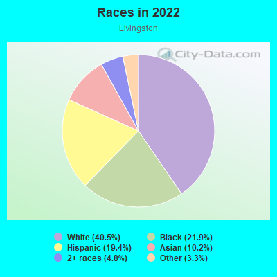
- 5,03340.5%White
- 2,71721.9%Black
- 2,41019.4%Hispanic or Latino
- 1,26410.2%Asian
- 6024.8%Two or more races
- 4083.3%Some other race
Median household income in 2022:
| Livingston: | $128,052 |
| New Jersey: | $96,346 |
Distribution of median household income
![Distribution of median household income]()
- 231Less than $10,000
- 383$10,000 to $19,999
- 242$20,000 to $29,999
- 466$30,000 to $39,999
- 211$40,000 to $49,999
- 222$50,000 to $59,999
- 275$60,000 to $74,999
- 450$75,000 to $99,999
- 526$100,000 to $124,999
- 456$125,000 to $149,999
- 634$150,000 to $199,999
- 1,135$200,000 or more

Distribution of owner-occupied house/condo value
![Distribution of owner-occupied house/condo value]()
- 309Less than $50,000
- 380$50,000 to $99,999
- 300$100,000 to $149,999
- 847$150,000 to $199,999
- 267$200,000 to $249,999
- 346$250,000 to $299,999
- 981$300,000 to $399,999
- 1,275$400,000 to $499,999
- 728$500,000 to $749,999
- 163$750,000 to $999,999
- 326$1,000,000 or more

Distribution of rent paid by renters
![Distribution of rent paid by renters]()
- 325$500 to $599
- 65$600 to $699
- 66$700 to $799
- 65$800 to $899
- 73$900 to $999
- 340$1,000 to $1,249
- 128$1,250 to $1,499
- 76$1,500 to $1,999
- 353$2,000 or more

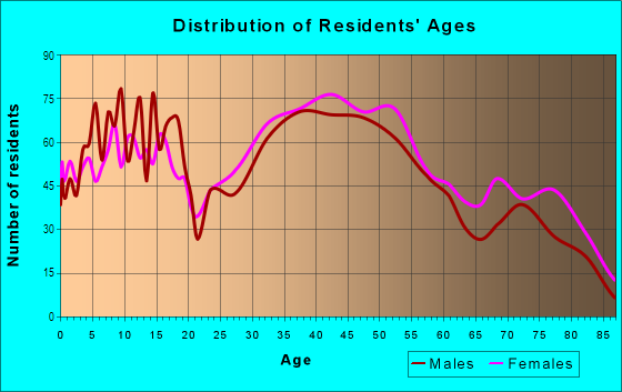
| Males: | 6,104 |
| Females: | 5,899 |
| Males: | 39.5 years |
| Females: | 42.4 years |
Average household size:
| Livingston: | 3.0 people |
| New Jersey: | 2.6 people |
Percentage of family households:
| Livingston: | 50.2% |
| New Jersey: | 47.0% |
| Here: | 56.5% |
| New Jersey: | 49.9% |
Percentage of married-couple families with children (among all households):
| Livingston: | 26.6% |
| New Jersey: | 51.5% |
Percentage of single-mother households (among all households):
| Livingston: | 4.0% |
| New Jersey: | 7.6% |
Percentage of never married males 15 years old and over:
Percentage of never married females 15 years old and over:
| Livingston: | 20.5% |
| New Jersey: | 18.2% |
Percentage of never married females 15 years old and over:
| Livingston: | 14.5% |
| New Jersey: | 16.6% |
Percentage of people that speak English not well or not at all:
| Livingston: | 3.7% |
| New Jersey: | 6.5% |
Percentage of people born in this state:
Percentage of people born in another U.S. state:
Percentage of native residents but born outside the U.S.:
Percentage of foreign born residents:
| Here: | 48.7% |
| New Jersey: | 50.7% |
Percentage of people born in another U.S. state:
| Livingston: | 15.7% |
| New Jersey: | 23.4% |
Percentage of native residents but born outside the U.S.:
| Here: | 3.9% |
| New Jersey: | 2.4% |
Percentage of foreign born residents:
| Here: | 31.7% |
| New Jersey: | 23.5% |
Owner-occupied
Renter-occupied

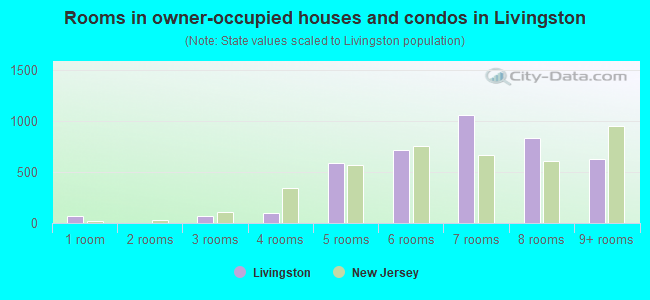
- Rooms in owner-occupied houses and condos in Livingston
- 641 room
- 02 rooms
- 643 rooms
- 1024 rooms
- 5915 rooms
- 7116 rooms
- 1,0587 rooms
- 8358 rooms
- 6309+ rooms
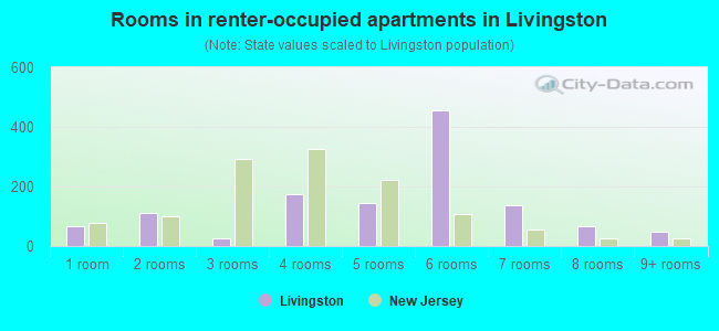
- Rooms in renter-occupied apartments in Livingston
- 671 room
- 1122 rooms
- 253 rooms
- 1734 rooms
- 1445 rooms
- 4556 rooms
- 1387 rooms
- 688 rooms
- 489+ rooms
Owner-occupied
Renter-occupied
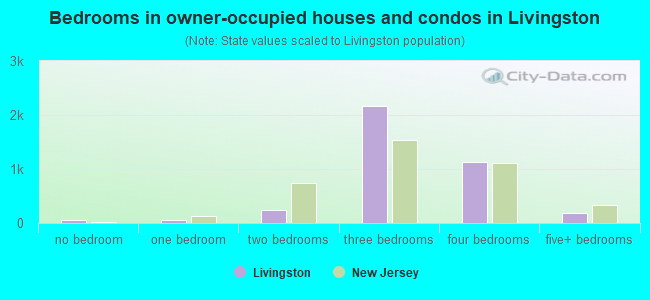
- Bedrooms in owner-occupied houses and condos in Livingston
- 64no bedroom
- 641 bedroom
- 2382 bedrooms
- 2,1753 bedrooms
- 1,1284 bedrooms
- 1925+ bedrooms
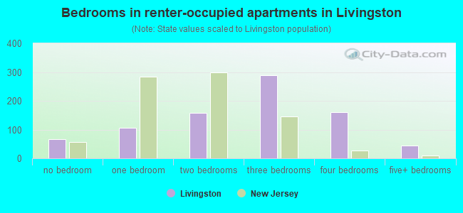
- Bedrooms in renter-occupied apartments in Livingston
- 67no bedroom
- 1051 bedroom
- 1592 bedrooms
- 2883 bedrooms
- 1604 bedrooms
- 455+ bedrooms
Average number of cars or other vehicles available in houses/condos:
Average number of cars or other vehicles available in apartments:
| This neighborhood: | 2.0 |
| New Jersey: | 2.0 |
Average number of cars or other vehicles available in apartments:
| Here: | |
| New Jersey: |
Percentage of units with a mortgage:
| Livingston: | 64.7% |
| New Jersey: | 63.3% |
Average estimated value of detached houses in 2022 (86.6% of all units):
| Livingston: | $418,554 |
| New Jersey: | $537,591 |
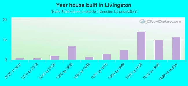
- Year house built in Livingston
- 752020 or later
- 772010 to 2019
- 2082000 to 2009
- 6891990 to 1999
- 1241980 to 1989
- 2841970 to 1979
- 4701960 to 1969
- 1,4131950 to 1959
- 1,0001940 to 1949
- 1,1481939 or earlier
City-data.com crime index for place in 2020 (higher means more crime):
| City: | 80.9 |
| U.S. average: | 219.5 |
Travel time to work (commute)
![Travel time to work (commute)]()
- 65Less than 5 minutes
- 2805 to 9 minutes
- 69410 to 14 minutes
- 65315 to 19 minutes
- 69120 to 24 minutes
- 41225 to 29 minutes
- 80930 to 34 minutes
- 3535 to 39 minutes
- 22340 to 44 minutes
- 56845 to 59 minutes
- 42360 to 89 minutes
- 15190 or more minutes

Means of transportation to work
![Means of transportation to work]()
- 70.1%4,386Drove a car alone
- 5.3%331Carpooled
- 3.6%224Bus
- 5.7%358Subway or elevated rail
- 5.3%329Long-distance train or commuter rail
- 0.9%55Light rail, streetcar or trolley
- 6.8%423Taxi
- 2.5%159Bicycle
- 2.2%137Walked
- 1.3%81Other means
- 14.0%875Worked at home

Time leaving home to go to work
![Time leaving home to go to work]()
- 29412:00 a.m. to 4:59 a.m.
- 2245:00 a.m. to 5:29 a.m.
- 1535:30 a.m. to 5:59 a.m.
- 2146:00 a.m. to 6:29 a.m.
- 1956:30 a.m. to 6:59 a.m.
- 9207:00 a.m. to 7:29 a.m.
- 6917:30 a.m. to 7:59 a.m.
- 9238:00 a.m. to 8:29 a.m.
- 3838:30 a.m. to 8:59 a.m.
- 2269:00 a.m. to 9:59 a.m.
- 3710:00 a.m. to 10:59 a.m.
- 9011:00 a.m. to 11:59 a.m.
- 34312:00 p.m. to 3:59 p.m.
- 3584:00 p.m. to 11:59 p.m.

Occupations of males:
- Percentage of males in management occupations (except farmers):
Here: 19.2% New Jersey: 13.9%
- Percentage of males in business and financial operations occupations:
Here: 6.1% New Jersey: 6.9%
- Percentage of males in computer and mathematical occupations:
Here: 9.2% New Jersey: 6.5%
- Percentage of males in architecture and engineering occupations:
Here: 4.2% New Jersey: 3.1%
- Percentage of males in community and social services occupations:
Here: 2.3% New Jersey: 1.1%
- Percentage of males in education, training, and library occupations:
Here: 3.3% New Jersey: 3.6%
- Percentage of males in arts, design, entertainment, sports, and media occupations:
Here: 1.8% New Jersey: 2.0%
- Percentage of males in healthcare practitioners and technical occupations:
Here: 4.0% New Jersey: 3.2%
- Percentage of males in service occupations:
Here: 8.0% New Jersey: 12.9%
- Percentage of males in sales and office occupations:
Here: 11.2% New Jersey: 15.3%
- Percentage of males in construction, extraction, and maintenance occupations:
Here: 6.2% New Jersey: 8.1%
- Percentage of males in production occupations:
Here: 1.8% New Jersey: 4.8%
- Percentage of males in transportation occupations:
Here: 9.1% New Jersey: 6.5%
- Percentage of males in material moving occupations:
Here: 8.2% New Jersey: 4.7%
Occupations of females:
- Percentage of females in management occupations (except farmers):
Here: 13.7% New Jersey: 10.4%
- Percentage of females in business and financial operations occupations:
Here: 10.6% New Jersey: 7.3%
- Percentage of females in computer and mathematical occupations:
Here: 4.6% New Jersey: 2.4%
- Percentage of females in architecture and engineering occupations:
Here: 1.2% New Jersey: 0.6%
- Percentage of females in life, physical, and social science occupations:
Here: 1.5% New Jersey: 1.4%
- Percentage of females in community and social services occupations:
Here: 1.4% New Jersey: 2.6%
- Percentage of females in legal occupations:
Here: 1.2% New Jersey: 1.6%
- Percentage of females in education, training, and library occupations:
Here: 8.8% New Jersey: 11.4%
- Percentage of females in arts, design, entertainment, sports, and media occupations:
Here: 3.0% New Jersey: 2.2%
- Percentage of females in healthcare practitioners and technical occupations:
Here: 8.6% New Jersey: 9.6%
- Percentage of females in service occupations:
Here: 12.4% New Jersey: 17.2%
- Percentage of females in sales and office occupations:
Here: 27.2% New Jersey: 26.7%
- Percentage of females in transportation occupations:
Here: 1.7% New Jersey: 1.2%
- Percentage of females in material moving occupations:
Here: 3.1% New Jersey: 2.4%
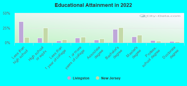
Education in this neighborhood (subdivision or community):
- Percentage of people 3 years and older in K-12 schools:
Livingston: 21.4% New Jersey: 16.6%
- Percentage of people 3 years and older in undergraduate colleges:
Livingston: 9.0% New Jersey: 4.9%
- Percentage of people 3 years and older in grad. or professional schools:
Livingston: 2.4% New Jersey: 1.6%
- Percentage of students K-12 enrolled in private schools:
Livingston: 66.1% New Jersey: 12.7%
Percentage of population below poverty level:
| Livingston: | 3.9% |
| New Jersey: | 9.7% |
Median year owner moved in (as recorded in 2022):
| Livingston: | 2005 |
| New Jersey: | 2008 |
Percentage of married-couple families with both working:
| Livingston: | 98.9% |
| New Jersey: | 72.0% |

- 66.3%Utility gas
- 8.0%Electricity
- 6.2%Fuel oil, kerosene, etc.
- 5.6%Solar energy
- 5.3%Bottled, tank, or LP gas
- 4.6%Other fuel
- 4.0%No fuel used
Highways in this neighborhood:
Morris Ave (State Rte 82)
Length: 1.85 miles
Directions: E-W, SE-NW
Address range: 1100 to 1876
Directions: E-W, SE-NW
Address range: 1100 to 1876
US Hwy 22
Length: 1.44 miles
Directions: E-W, SW-NE
Address range: 289 to 899
Directions: E-W, SW-NE
Address range: 289 to 899
Garden State Pkwy
Length: 0.92 miles
Direction: SW-NE
Direction: SW-NE
Roads and streets:
Salem Rd (State Rte 509)
Length: 1.76 miles
Directions: E-W, SW-NE
Address range: 374 to 1199
Directions: E-W, SW-NE
Address range: 374 to 1199
Lehigh Ave
Length: 1.63 miles
Direction: SW-NE
Address range: 424 to 999
Direction: SW-NE
Address range: 424 to 999
Vauxhall Rd
Length: 1.26 miles
Directions: E-W, N-S, SE-NW
Address range: 1001 to 1779
Directions: E-W, N-S, SE-NW
Address range: 1001 to 1779
Winchester Ave
Length: 0.81 miles
Directions: E-W, N-S, SE-NW, SW-NE
Address range: 472 to 742
Directions: E-W, N-S, SE-NW, SW-NE
Address range: 472 to 742
Colonial Arms Rd
Length: 0.67 miles
Directions: N-S, SE-NW, SW-NE
Address range: 600 to 859
Directions: N-S, SE-NW, SW-NE
Address range: 600 to 859
Colonial Ave
Length: 0.62 miles
Directions: E-W, SW-NE
Address range: 608 to 986
Directions: E-W, SW-NE
Address range: 608 to 986
Sayre Rd
Length: 0.55 miles
Directions: E-W, N-S, SE-NW, SW-NE
Address range: 1000 to 1199
Directions: E-W, N-S, SE-NW, SW-NE
Address range: 1000 to 1199
Brookside Dr
Length: 0.53 miles
Directions: E-W, SW-NE
Address range: 1360 to 1541
Directions: E-W, SW-NE
Address range: 1360 to 1541
Lorraine Ave
Length: 0.49 miles
Direction: SW-NE
Address range: 878 to 1099
Direction: SW-NE
Address range: 878 to 1099
Potter Ave
Length: 0.49 miles
Directions: N-S, SW-NE
Address range: 913 to 1105
Directions: N-S, SW-NE
Address range: 913 to 1105
Huguenot Ave
Length: 0.45 miles
Direction: SE-NW
Address range: 264 to 421
Direction: SE-NW
Address range: 264 to 421
Huntington Rd
Length: 0.44 miles
Direction: SW-NE
Address range: 293 to 465
Direction: SW-NE
Address range: 293 to 465
Townley Ave
Length: 0.44 miles
Directions: E-W, SW-NE
Address range: 797 to 1098
Directions: E-W, SW-NE
Address range: 797 to 1098
Forest Dr
Length: 0.43 miles
Direction: SW-NE
Address range: 269 to 433
Direction: SW-NE
Address range: 269 to 433
Minute Arms Rd
Length: 0.43 miles
Directions: SE-NW, SW-NE
Address range: 246 to 406
Directions: SE-NW, SW-NE
Address range: 246 to 406
Galloping Hill Rd
Length: 0.40 miles
Directions: E-W, SE-NW
Address range: 801 to 995
Directions: E-W, SE-NW
Address range: 801 to 995
Erhardt St
Length: 0.39 miles
Direction: SW-NE
Address range: 1129 to 1299
Direction: SW-NE
Address range: 1129 to 1299
Midland Blvd
Length: 0.39 miles
Direction: SW-NE
Address range: 700 to 999
Direction: SW-NE
Address range: 700 to 999
Cranbrook Dr (Cranbrook Rd)
Length: 0.36 miles
Directions: E-W, N-S, SE-NW, SW-NE
Address range: 1000 to 1135
Directions: E-W, N-S, SE-NW, SW-NE
Address range: 1000 to 1135
Reeves Ter
Length: 0.35 miles
Directions: E-W, N-S, SE-NW, SW-NE
Address range: 1044 to 1199
Directions: E-W, N-S, SE-NW, SW-NE
Address range: 1044 to 1199
Wayne Ter
Length: 0.34 miles
Direction: SE-NW
Address range: 293 to 440
Direction: SE-NW
Address range: 293 to 440
Sherwood Rd
Length: 0.34 miles
Direction: SE-NW
Address range: 298 to 419
Direction: SE-NW
Address range: 298 to 419
Biscayne Blvd
Length: 0.33 miles
Directions: E-W, N-S, SE-NW, SW-NE
Address range: 1200 to 1357
Directions: E-W, N-S, SE-NW, SW-NE
Address range: 1200 to 1357
Broadwell Ave
Length: 0.32 miles
Direction: SE-NW
Address range: 300 to 418
Direction: SE-NW
Address range: 300 to 418
Carteret Ave
Length: 0.32 miles
Direction: SW-NE
Address range: 860 to 999
Direction: SW-NE
Address range: 860 to 999
Putnam Rd
Length: 0.32 miles
Direction: SE-NW
Address range: 300 to 429
Direction: SE-NW
Address range: 300 to 429
Beverly Rd
Length: 0.31 miles
Direction: SE-NW
Address range: 1217 to 1399
Direction: SE-NW
Address range: 1217 to 1399
Martin Rd
Length: 0.31 miles
Direction: SW-NE
Address range: 300 to 419
Direction: SW-NE
Address range: 300 to 419
Suburban Rd
Length: 0.31 miles
Direction: SW-NE
Address range: 700 to 999
Direction: SW-NE
Address range: 700 to 999
Brookfall Ave
Length: 0.29 miles
Directions: E-W, N-S, SW-NE
Address range: 1300 to 1399
Directions: E-W, N-S, SW-NE
Address range: 1300 to 1399
Foxwood Rd
Length: 0.29 miles
Directions: N-S, SW-NE
Address range: 297 to 413
Directions: N-S, SW-NE
Address range: 297 to 413
Marcella Dr
Length: 0.28 miles
Directions: E-W, N-S, SE-NW, SW-NE
Address range: 1244 to 1348
Directions: E-W, N-S, SE-NW, SW-NE
Address range: 1244 to 1348
Scotland Rd
Length: 0.28 miles
Directions: E-W, N-S, SE-NW, SW-NE
Address range: 500 to 599
Directions: E-W, N-S, SE-NW, SW-NE
Address range: 500 to 599
Churchill Dr
Length: 0.28 miles
Directions: E-W, N-S, SE-NW, SW-NE
Address range: 1900 to 2011
Directions: E-W, N-S, SE-NW, SW-NE
Address range: 1900 to 2011
Greenwood Rd S
Length: 0.28 miles
Direction: SW-NE
Address range: 614 to 799
Direction: SW-NE
Address range: 614 to 799
Greenwich Ln (Greenwich Ave)
Length: 0.27 miles
Directions: E-W, SE-NW, SW-NE
Address range: 800 to 900
Directions: E-W, SE-NW, SW-NE
Address range: 800 to 900
Duquesne Ter
Length: 0.26 miles
Directions: E-W, SW-NE
Address range: 581 to 699
Directions: E-W, SW-NE
Address range: 581 to 699
Twin Oaks Rd
Length: 0.26 miles
Direction: SE-NW
Address range: 427 to 599
Direction: SE-NW
Address range: 427 to 599
Sterling Rd
Length: 0.25 miles
Direction: SW-NE
Address range: 1000 to 1099
Direction: SW-NE
Address range: 1000 to 1099
Plymouth Rd
Length: 0.25 miles
Direction: SE-NW
Address range: 291 to 399
Direction: SE-NW
Address range: 291 to 399
Euclid Ave
Length: 0.25 miles
Direction: SE-NW
Address range: 2 to 969
Direction: SE-NW
Address range: 2 to 969
Wildwood Ter
Length: 0.24 miles
Direction: E-W
Address range: 1200 to 1299
Direction: E-W
Address range: 1200 to 1299
Nottingham Way
Length: 0.24 miles
Directions: N-S, SE-NW, SW-NE
Address range: 300 to 399
Directions: N-S, SE-NW, SW-NE
Address range: 300 to 399
Yorktown Rd
Length: 0.24 miles
Direction: SW-NE
Address range: 500 to 599
Direction: SW-NE
Address range: 500 to 599
Nixon Rd
Length: 0.22 miles
Direction: SW-NE
Address range: 753 to 838
Direction: SW-NE
Address range: 753 to 838
Fulton St S
Length: 0.21 miles
Direction: SE-NW
Direction: SE-NW
Arnet Ave
Length: 0.21 miles
Direction: SW-NE
Address range: 900 to 999
Direction: SW-NE
Address range: 900 to 999
Clark Pl
Length: 0.20 miles
Direction: SE-NW
Address range: 102 to 511
Direction: SE-NW
Address range: 102 to 511
Fairfield Way
Length: 0.19 miles
Directions: E-W, SW-NE
Address range: 634 to 701
Directions: E-W, SW-NE
Address range: 634 to 701
Bertram Ter
Length: 0.18 miles
Direction: SW-NE
Address range: 1000 to 1074
Direction: SW-NE
Address range: 1000 to 1074
Princeton Rd
Length: 0.18 miles
Directions: E-W, SE-NW
Address range: 316 to 399
Directions: E-W, SE-NW
Address range: 316 to 399
Carpenter Pl
Length: 0.18 miles
Direction: SE-NW
Address range: 17 to 511
Direction: SE-NW
Address range: 17 to 511
Maple St
Length: 0.17 miles
Direction: SW-NE
Address range: 148 to 898
Direction: SW-NE
Address range: 148 to 898
Balsam Way S
Length: 0.17 miles
Direction: SW-NE
Address range: 700 to 753
Direction: SW-NE
Address range: 700 to 753
Stockton Rd
Length: 0.16 miles
Direction: SE-NW
Address range: 300 to 362
Direction: SE-NW
Address range: 300 to 362
Patton Rd
Length: 0.16 miles
Direction: SW-NE
Address range: 1934 to 2011
Direction: SW-NE
Address range: 1934 to 2011
Barton Rd
Length: 0.16 miles
Directions: E-W, SE-NW
Address range: 1536 to 1599
Directions: E-W, SE-NW
Address range: 1536 to 1599
Lexington Rd
Length: 0.16 miles
Direction: SW-NE
Address range: 646 to 699
Direction: SW-NE
Address range: 646 to 699
Roger Ave
Length: 0.16 miles
Directions: E-W, SW-NE
Address range: 1200 to 1255
Directions: E-W, SW-NE
Address range: 1200 to 1255
Highland Ave
Length: 0.15 miles
Direction: SW-NE
Address range: 1200 to 1271
Direction: SW-NE
Address range: 1200 to 1271
Bennington Dr
Length: 0.15 miles
Direction: SW-NE
Address range: 592 to 645
Direction: SW-NE
Address range: 592 to 645
Gray Ave
Length: 0.15 miles
Direction: E-W
Address range: 1200 to 1245
Direction: E-W
Address range: 1200 to 1245
Brookside Ave
Length: 0.15 miles
Direction: E-W
Address range: 1200 to 1244
Direction: E-W
Address range: 1200 to 1244
Cornell Pl
Length: 0.14 miles
Directions: N-S, SE-NW, SW-NE
Address range: 1363 to 1457
Directions: N-S, SE-NW, SW-NE
Address range: 1363 to 1457
Lum Ave
Length: 0.14 miles
Direction: SE-NW
Address range: 352 to 427
Direction: SE-NW
Address range: 352 to 427
Field Rd
Length: 0.14 miles
Directions: N-S, SW-NE
Address range: 1000 to 1061
Directions: N-S, SW-NE
Address range: 1000 to 1061
Gustav Ave
Length: 0.14 miles
Direction: N-S
Address range: 1370 to 1435
Direction: N-S
Address range: 1370 to 1435
Prescott Rd
Length: 0.14 miles
Direction: SE-NW
Address range: 392 to 444
Direction: SE-NW
Address range: 392 to 444
Reindel Pl
Length: 0.14 miles
Directions: E-W, SE-NW, SW-NE
Address range: 300 to 399
Directions: E-W, SE-NW, SW-NE
Address range: 300 to 399
Union County Pkwy
Length: 0.14 miles
Directions: E-W, SE-NW
Address range: 1488 to 1522
Directions: E-W, SE-NW
Address range: 1488 to 1522
Schuyler Way
Length: 0.14 miles
Direction: SW-NE
Address range: 529 to 599
Direction: SW-NE
Address range: 529 to 599
Faitoute Ave
Length: 0.14 miles
Directions: E-W, SW-NE
Address range: 1200 to 1255
Directions: E-W, SW-NE
Address range: 1200 to 1255
Azalea Rd
Length: 0.13 miles
Directions: N-S, SW-NE
Address range: 1000 to 1099
Directions: N-S, SW-NE
Address range: 1000 to 1099
Norton Rd
Length: 0.13 miles
Direction: SW-NE
Address range: 1000 to 1051
Direction: SW-NE
Address range: 1000 to 1051
Meade Ter
Length: 0.13 miles
Directions: N-S, SE-NW
Address range: 315 to 373
Directions: N-S, SE-NW
Address range: 315 to 373
Harmony Rd
Length: 0.13 miles
Direction: SW-NE
Address range: 1150 to 1199
Direction: SW-NE
Address range: 1150 to 1199
Dean Ter
Length: 0.12 miles
Direction: E-W
Address range: 1 to 43
Direction: E-W
Address range: 1 to 43
Skyview Rd
Length: 0.12 miles
Directions: E-W, N-S, SE-NW, SW-NE
Address range: 1 to 54
Directions: E-W, N-S, SE-NW, SW-NE
Address range: 1 to 54
Magnolia Pl
Length: 0.12 miles
Direction: N-S
Address range: 1200 to 1260
Direction: N-S
Address range: 1200 to 1260
Higa Ter
Length: 0.12 miles
Direction: SE-NW
Address range: 1 to 1208
Direction: SE-NW
Address range: 1 to 1208
Summit Pl
Length: 0.11 miles
Direction: SE-NW
Address range: 1394 to 1427
Direction: SE-NW
Address range: 1394 to 1427
Halsey Ave
Length: 0.11 miles
Direction: SE-NW
Address range: 290 to 399
Direction: SE-NW
Address range: 290 to 399
Jensen Ln
Length: 0.10 miles
Direction: SE-NW
Address range: 1 to 43
Direction: SE-NW
Address range: 1 to 43
Cranbury Rd
Length: 0.10 miles
Direction: SE-NW
Address range: 1117 to 1151
Direction: SE-NW
Address range: 1117 to 1151
Balsam Way
Length: 0.10 miles
Direction: SW-NE
Address range: 760 to 999
Direction: SW-NE
Address range: 760 to 999
Lancaster Rd
Length: 0.10 miles
Directions: SE-NW, SW-NE
Address range: 1 to 42
Directions: SE-NW, SW-NE
Address range: 1 to 42
Connecticut Rd
Length: 0.09 miles
Direction: SE-NW
Address range: 200 to 248
Direction: SE-NW
Address range: 200 to 248
Thelma Dr
Length: 0.09 miles
Directions: E-W, SW-NE
Address range: 1400 to 1447
Directions: E-W, SW-NE
Address range: 1400 to 1447
Oak Pl
Length: 0.09 miles
Directions: N-S, SW-NE
Address range: 1200 to 1246
Directions: N-S, SW-NE
Address range: 1200 to 1246
Greenwood Rd
Length: 0.09 miles
Direction: SW-NE
Address range: 969 to 999
Direction: SW-NE
Address range: 969 to 999
Trent Pl
Length: 0.09 miles
Directions: E-W, SE-NW
Address range: 1033 to 1061
Directions: E-W, SE-NW
Address range: 1033 to 1061
Kingswood Rd
Length: 0.09 miles
Directions: N-S, SW-NE
Address range: 1000 to 1044
Directions: N-S, SW-NE
Address range: 1000 to 1044
Chelsea Ter
Length: 0.09 miles
Direction: E-W
Address range: 840 to 881
Direction: E-W
Address range: 840 to 881
Prospect St
Length: 0.09 miles
Direction: SW-NE
Address range: 864 to 899
Direction: SW-NE
Address range: 864 to 899
Dewight Ter
Length: 0.09 miles
Directions: SE-NW, SW-NE
Address range: 614 to 657
Directions: SE-NW, SW-NE
Address range: 614 to 657
Alden Ter
Length: 0.08 miles
Direction: SE-NW
Address range: 1300 to 1334
Direction: SE-NW
Address range: 1300 to 1334
Cambridge Dr
Length: 0.08 miles
Directions: N-S, SE-NW
Address range: 327 to 366
Directions: N-S, SE-NW
Address range: 327 to 366
Robert St
Length: 0.08 miles
Direction: SW-NE
Address range: 1200 to 1280
Direction: SW-NE
Address range: 1200 to 1280
Darby Ln
Length: 0.08 miles
Direction: SE-NW
Address range: 1120 to 1152
Direction: SE-NW
Address range: 1120 to 1152
Randolph Pl
Length: 0.08 miles
Direction: SE-NW
Address range: 861 to 906
Direction: SE-NW
Address range: 861 to 906
Clifton Ter
Length: 0.07 miles
Direction: N-S
Address range: 1200 to 1239
Direction: N-S
Address range: 1200 to 1239
Richmond Pl
Length: 0.07 miles
Direction: SE-NW
Address range: 1117 to 1137
Direction: SE-NW
Address range: 1117 to 1137
Whitewood Rd
Length: 0.07 miles
Directions: N-S, SE-NW
Address range: 270 to 307
Directions: N-S, SE-NW
Address range: 270 to 307
Reimar Ct
Length: 0.07 miles
Directions: N-S, SW-NE
Directions: N-S, SW-NE
Terry Ln
Length: 0.06 miles
Direction: SW-NE
Direction: SW-NE
Trinity Pl
Length: 0.06 miles
Direction: SE-NW
Direction: SE-NW
Martin Pl
Length: 0.06 miles
Directions: E-W, SE-NW
Directions: E-W, SE-NW
Livingston Ave S
Length: 0.06 miles
Direction: SE-NW
Direction: SE-NW
N Sunset Pl
Length: 0.06 miles
Direction: SE-NW
Address range: 1601 to 1619
Direction: SE-NW
Address range: 1601 to 1619
Pitcher Ter
Length: 0.06 miles
Direction: SE-NW
Address range: 361 to 399
Direction: SE-NW
Address range: 361 to 399
Hampton St
Length: 0.06 miles
Direction: SE-NW
Direction: SE-NW
Normandy Ter
Length: 0.06 miles
Direction: SE-NW
Direction: SE-NW
Dover Ln
Length: 0.06 miles
Direction: SE-NW
Direction: SE-NW
Susan Pl
Length: 0.05 miles
Direction: E-W
Address range: 1062 to 1099
Direction: E-W
Address range: 1062 to 1099
Beth Ln
Length: 0.05 miles
Direction: SW-NE
Direction: SW-NE
Glouster Rd
Length: 0.05 miles
Direction: N-S
Address range: 874 to 907
Direction: N-S
Address range: 874 to 907
Scott Ct
Length: 0.05 miles
Direction: SE-NW
Address range: 400 to 419
Direction: SE-NW
Address range: 400 to 419
Oakland Ave
Length: 0.04 miles
Direction: SE-NW
Direction: SE-NW
Elberson Ct
Length: 0.04 miles
Direction: N-S
Address range: 1 to 31
Direction: N-S
Address range: 1 to 31
Robin Ln
Length: 0.03 miles
Direction: SE-NW
Address range: 1085 to 1099
Direction: SE-NW
Address range: 1085 to 1099
Short Dr
Length: 0.03 miles
Direction: N-S
Address range: 1 to 10
Direction: N-S
Address range: 1 to 10
Joanna Way
Length: 0.03 miles
Direction: SE-NW
Address range: 1484 to 1499
Direction: SE-NW
Address range: 1484 to 1499
Louis Pl
Length: 0.02 miles
Direction: E-W
Address range: 131 to 161
Direction: E-W
Address range: 131 to 161
Railroad features:
Conrail RR
Length: 1.65 miles
Direction: SW-NE
Direction: SW-NE
Other features:
Elizabeth River W Br
Length: 1.81 miles
Directions: E-W, N-S, SE-NW, SW-NE
Directions: E-W, N-S, SE-NW, SW-NE
Elizabeth Riv
Length: 0.81 miles
Directions: E-W, N-S, SE-NW, SW-NE
Directions: E-W, N-S, SE-NW, SW-NE