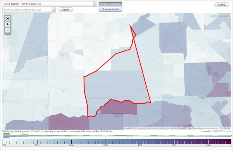
Minnetex neighborhood in Houston, Texas (TX), 77048 detailed profile
Settings
X

Business Search - 14 Million verified businesses
Area: 8.511 square miles
Population: 16,761
Population density:
| Minnetex: | 1,969 people per square mile |
| Houston: | 3,977 people per square mile |

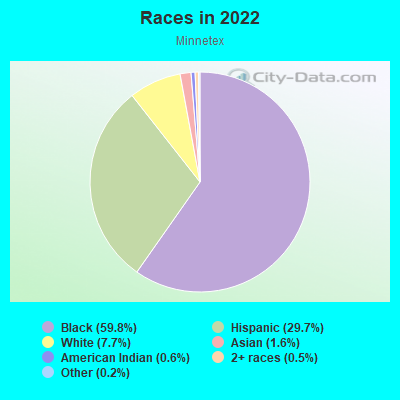
- 10,87459.8%Black
- 5,40229.7%Hispanic or Latino
- 1,3997.7%White
- 2901.6%Asian
- 1030.6%American Indian
- 890.5%Two or more races
- 360.2%Some other race
Distribution of median household income
![Distribution of median household income]()
- 916Less than $10,000
- 1,160$10,000 to $19,999
- 306$20,000 to $29,999
- 581$30,000 to $39,999
- 476$40,000 to $49,999
- 147$50,000 to $59,999
- 872$60,000 to $74,999
- 293$75,000 to $99,999
- 625$100,000 to $124,999
- 525$125,000 to $149,999
- 205$150,000 to $199,999
- 1,153$200,000 or more

Distribution of owner-occupied house/condo value
![Distribution of owner-occupied house/condo value]()
- 742Less than $50,000
- 705$50,000 to $99,999
- 790$100,000 to $149,999
- 810$150,000 to $199,999
- 68$200,000 to $249,999
- 344$250,000 to $299,999
- 123$300,000 to $399,999
- 271$400,000 to $499,999
- 296$500,000 to $749,999
- 158$1,000,000 or more

Distribution of rent paid by renters
![Distribution of rent paid by renters]()
- 193$100 to $199
- 487$200 to $299
- 102$400 to $499
- 120$500 to $599
- 420$600 to $699
- 557$700 to $799
- 652$800 to $899
- 352$900 to $999
- 612$1,000 to $1,249
- 206$1,250 to $1,499
- 37$1,500 to $1,999

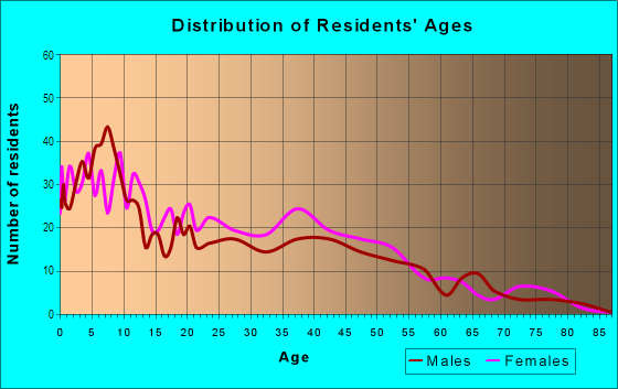
| Males: | 7,298 |
| Females: | 9,463 |
Males:
| This neighborhood: | 33.0 years |
| Whole city: | 34.4 years |
| This neighborhood: | 35.6 years |
| Whole city: | 34.7 years |
Average household size:
| Minnetex: | 8.8 people |
| Houston: | 2.4 people |
Percentage of family households:
| Minnetex: | 65.0% |
| Houston: | 43.0% |
| Here: | 40.2% |
| Houston: | 34.7% |
Percentage of married-couple families with children (among all households):
| Minnetex: | 10.7% |
| Houston: | 23.3% |
Percentage of single-mother households (among all households):
| Minnetex: | 20.4% |
| Houston: | 13.9% |
Percentage of never married males 15 years old and over:
Percentage of never married females 15 years old and over:
| Minnetex: | 12.9% |
| Houston: | 22.9% |
Percentage of never married females 15 years old and over:
| Minnetex: | 25.2% |
| city: | 21.2% |
Percentage of people that speak English not well or not at all:
| Minnetex: | 7.9% |
| Houston: | 15.9% |
Percentage of people born in this state:
Percentage of people born in another U.S. state:
Percentage of native residents but born outside the U.S.:
Percentage of foreign born residents:
| Here: | 78.5% |
| Houston: | 51.1% |
Percentage of people born in another U.S. state:
| Minnetex: | 9.8% |
| Houston: | 17.7% |
Percentage of native residents but born outside the U.S.:
| Here: | 0.5% |
| city: | 1.8% |
Percentage of foreign born residents:
| Here: | 11.3% |
| Houston: | 29.4% |
Owner-occupied
Renter-occupied

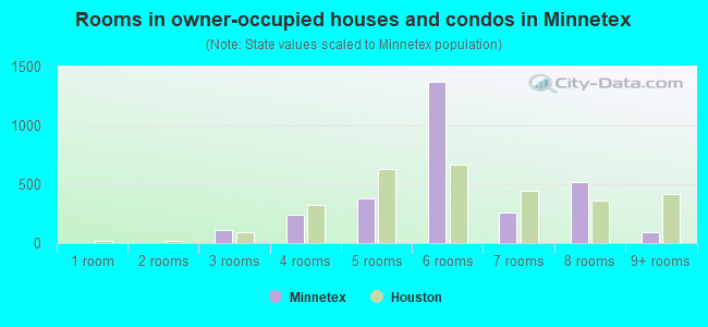
- Rooms in owner-occupied houses and condos in Minnetex
- 31 room
- 02 rooms
- 1153 rooms
- 2434 rooms
- 3805 rooms
- 1,3686 rooms
- 2597 rooms
- 5228 rooms
- 889+ rooms
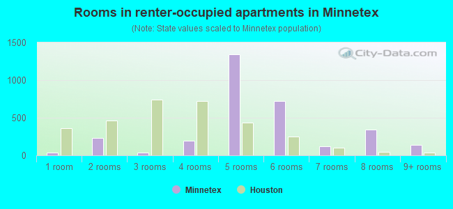
- Rooms in renter-occupied apartments in Minnetex
- 351 room
- 2332 rooms
- 373 rooms
- 1934 rooms
- 1,3395 rooms
- 7256 rooms
- 1167 rooms
- 3388 rooms
- 1429+ rooms
Owner-occupied
Renter-occupied
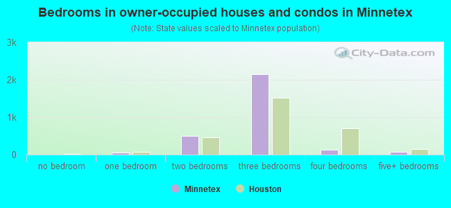
- Bedrooms in owner-occupied houses and condos in Minnetex
- 3no bedroom
- 581 bedroom
- 4922 bedrooms
- 2,1533 bedrooms
- 1334 bedrooms
- 725+ bedrooms
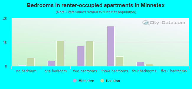
- Bedrooms in renter-occupied apartments in Minnetex
- 35no bedroom
- 2281 bedroom
- 8362 bedrooms
- 1,6723 bedrooms
- 1914 bedrooms
- 05+ bedrooms
Average number of cars or other vehicles available in houses/condos:
Average number of cars or other vehicles available in apartments:
| This neighborhood: | 1.9 |
| Houston: | 2.0 |
Average number of cars or other vehicles available in apartments:
| Here: | 1.3 |
| city: | 1.3 |
Percentage of units with a mortgage:
| Minnetex: | 74.9% |
| Houston: | 50.8% |
Average estimated value of detached houses in 2022 (64.9% of all units):
| Minnetex: | $209,254 |
| Houston: | $368,067 |
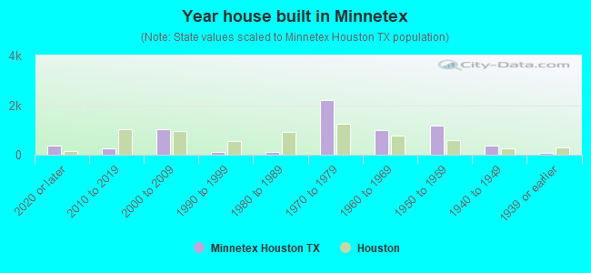
- Year house built in Minnetex
- 3682020 or later
- 2542010 to 2019
- 1,0332000 to 2009
- 1221990 to 1999
- 1211980 to 1989
- 2,2041970 to 1979
- 9781960 to 1969
- 1,1861950 to 1959
- 3701940 to 1949
- 851939 or earlier
City-data.com crime index for city in 2020 (higher means more crime):
| City: | 560.9 |
| U.S. average: | 219.5 |
Travel time to work (commute)
![Travel time to work (commute)]()
- 126Less than 5 minutes
- 495 to 9 minutes
- 13310 to 14 minutes
- 11715 to 19 minutes
- 42620 to 24 minutes
- 27425 to 29 minutes
- 69930 to 34 minutes
- 17035 to 39 minutes
- 12540 to 44 minutes
- 39645 to 59 minutes
- 13660 to 89 minutes
- 15390 or more minutes

Means of transportation to work
![Means of transportation to work]()
- 87.2%4,396Drove a car alone
- 2.3%118Carpooled
- 5.9%297Bus
- 0.7%35Subway or elevated rail
- 0.3%14Motorcycle
- 2.7%136Walked
- 0.6%29Other means
- 4.9%249Worked at home

Time leaving home to go to work
![Time leaving home to go to work]()
- 22512:00 a.m. to 4:59 a.m.
- 1475:00 a.m. to 5:29 a.m.
- 1855:30 a.m. to 5:59 a.m.
- 2906:00 a.m. to 6:29 a.m.
- 3336:30 a.m. to 6:59 a.m.
- 6297:00 a.m. to 7:29 a.m.
- 1637:30 a.m. to 7:59 a.m.
- 2218:00 a.m. to 8:29 a.m.
- 1028:30 a.m. to 8:59 a.m.
- 969:00 a.m. to 9:59 a.m.
- 7310:00 a.m. to 10:59 a.m.
- 1711:00 a.m. to 11:59 a.m.
- 14912:00 p.m. to 3:59 p.m.
- 1574:00 p.m. to 11:59 p.m.

Occupations of males:
- Percentage of males in management occupations (except farmers):
Here: 4.9% city: 10.6%
- Percentage of males in business and financial operations occupations:
Here: 2.8% city: 5.4%
- Percentage of males in service occupations:
Here: 21.0% city: 12.9%
- Percentage of males in sales and office occupations:
Here: 14.4% city: 13.5%
- Percentage of males in construction, extraction, and maintenance occupations:
Here: 14.5% city: 15.7%
- Percentage of males in production occupations:
Here: 10.6% city: 6.0%
- Percentage of males in transportation occupations:
Here: 3.1% city: 6.1%
- Percentage of males in material moving occupations:
Here: 3.6% city: 5.4%
Occupations of females:
- Percentage of females in management occupations (except farmers):
Here: 11.0% city: 8.6%
- Percentage of females in business and financial operations occupations:
Here: 8.0% city: 6.8%
- Percentage of females in education, training, and library occupations:
Here: 23.4% city: 8.5%
- Percentage of females in service occupations:
Here: 40.7% city: 23.8%
- Percentage of females in sales and office occupations:
Here: 16.0% city: 26.6%
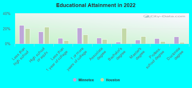
Education in this neighborhood (subdivision or community):
- Percentage of people 3 years and older in K-12 schools:
Minnetex: 27.1% Houston: 16.6%
- Percentage of people 3 years and older in undergraduate colleges:
Minnetex: 3.5% Houston: 4.6%
- Percentage of people 3 years and older in grad. or professional schools:
Minnetex: 0.2% Houston: 1.6%
- Percentage of students K-12 enrolled in private schools:
Minnetex: 18.2% Houston: 9.0%
Percentage of population below poverty level:
| Minnetex: | 32.9% |
| Houston: | 20.7% |
Median year owner moved in (as recorded in 2022):
Median year renter moved in (as recorded in 2022):
| Minnetex: | 2003 |
| Houston: | 2010 |
Median year renter moved in (as recorded in 2022):
| Minnetex: | 2013 |
| Houston: | 2020 |
Percentage of married-couple families with both working:
| Minnetex: | 133.3% |
| Houston: | 54.9% |
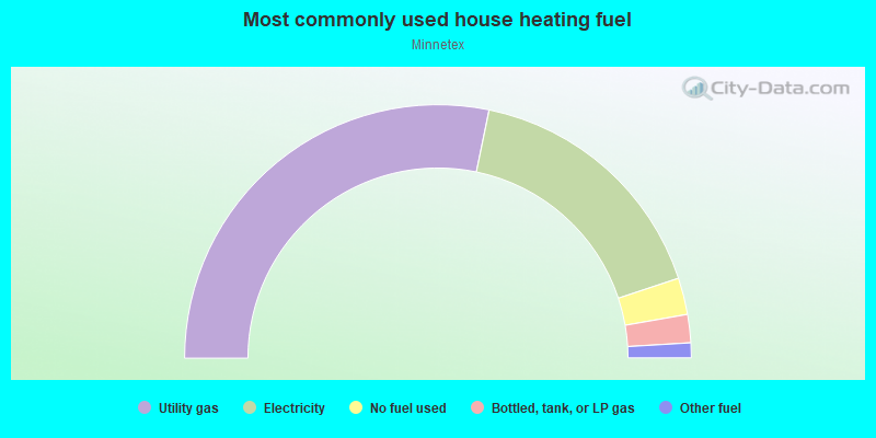
- 56.5%Utility gas
- 33.3%Electricity
- 4.7%No fuel used
- 3.6%Bottled, tank, or LP gas
- 1.9%Other fuel
Other features:
Clear Crk
Length: 1.78 miles
Directions: E-W, N-S, SE-NW, SW-NE
Directions: E-W, N-S, SE-NW, SW-NE
Highways in this neighborhood:
Beltway 8 (Sam Houston Pkwy, State Loop 8)
Length: 7.60 miles
Direction: E-W
Direction: E-W
Roads and streets:
Mykawa Rd
Length: 3.97 miles
Direction: N-S
Address range: 7001 to 12291
Direction: N-S
Address range: 7001 to 12291
Schurmier Rd
Length: 3.50 miles
Direction: E-W
Address range: 4200 to 6999
Direction: E-W
Address range: 4200 to 6999
Allison Rd
Length: 3.11 miles
Direction: E-W
Address range: 4400 to 6399
Direction: E-W
Address range: 4400 to 6399
Fuqua St
Length: 2.03 miles
Direction: E-W
Address range: 4800 to 6499
Direction: E-W
Address range: 4800 to 6499
Almeda-Genoa Rd
Length: 1.83 miles
Direction: E-W
Address range: 5243 to 6618
Direction: E-W
Address range: 5243 to 6618
S Wayside Dr
Length: 1.58 miles
Direction: N-S
Address range: 13000 to 14499
Direction: N-S
Address range: 13000 to 14499
Martindale Rd
Length: 1.54 miles
Direction: N-S
Address range: 10000 to 12999
Direction: N-S
Address range: 10000 to 12999
Cottingham St
Length: 1.37 miles
Directions: N-S, SW-NE
Address range: 13100 to 14899
Directions: N-S, SW-NE
Address range: 13100 to 14899
Foxton Rd
Length: 1.26 miles
Directions: N-S, SW-NE
Address range: 12200 to 13599
Directions: N-S, SW-NE
Address range: 12200 to 13599
Mary Kay Ln
Length: 1.23 miles
Directions: E-W, N-S
Address range: 13900 to 14999
Directions: E-W, N-S
Address range: 13900 to 14999
Willardville Rd
Length: 1.23 miles
Direction: E-W
Address range: 5600 to 6899
Direction: E-W
Address range: 5600 to 6899
Selinsky Rd
Length: 1.21 miles
Direction: E-W
Address range: 5898 to 6799
Direction: E-W
Address range: 5898 to 6799
Carson Rd
Length: 1.14 miles
Direction: E-W
Address range: 6100 to 6899
Direction: E-W
Address range: 6100 to 6899
S Acres Dr
Length: 1.07 miles
Direction: E-W
Address range: 5881 to 6699
Direction: E-W
Address range: 5881 to 6699
Madden Ln
Length: 1.05 miles
Direction: E-W
Address range: 6100 to 6799
Direction: E-W
Address range: 6100 to 6799
Old Chocolate Bayou Rd
Length: 1.00 miles
Direction: N-S
Address range: 13900 to 14605
Direction: N-S
Address range: 13900 to 14605
Carter
Length: 0.96 miles
Direction: E-W
Direction: E-W
Dagg Rd
Length: 0.76 miles
Directions: E-W, N-S, SE-NW, SW-NE
Address range: 4200 to 4799
Directions: E-W, N-S, SE-NW, SW-NE
Address range: 4200 to 4799
Airport Blvd
Length: 0.73 miles
Directions: E-W, SW-NE
Address range: 6100 to 6699
Directions: E-W, SW-NE
Address range: 6100 to 6699
Scarlet Dr
Length: 0.66 miles
Direction: E-W
Address range: 6100 to 6699
Direction: E-W
Address range: 6100 to 6699
Max Rd
Length: 0.63 miles
Direction: N-S
Direction: N-S
Kier Rd
Length: 0.61 miles
Direction: N-S
Direction: N-S
Glengarry Rd
Length: 0.61 miles
Direction: E-W
Address range: 4500 to 4999
Direction: E-W
Address range: 4500 to 4999
Lincolnshire Rd
Length: 0.61 miles
Direction: E-W
Address range: 4500 to 4999
Direction: E-W
Address range: 4500 to 4999
Grosbeak Dr
Length: 0.59 miles
Direction: E-W
Address range: 6100 to 6599
Direction: E-W
Address range: 6100 to 6599
Osprey Dr
Length: 0.59 miles
Direction: E-W
Address range: 6000 to 6599
Direction: E-W
Address range: 6000 to 6599
Trescon Dr
Length: 0.56 miles
Direction: E-W
Address range: 5900 to 6299
Direction: E-W
Address range: 5900 to 6299
Sesame
Length: 0.50 miles
Directions: E-W, N-S, SE-NW, SW-NE
Directions: E-W, N-S, SE-NW, SW-NE
Journey Rd
Length: 0.49 miles
Direction: N-S
Direction: N-S
Border
Length: 0.49 miles
Direction: N-S
Direction: N-S
Station Dr
Length: 0.48 miles
Directions: N-S, SE-NW
Address range: 7000 to 7599
Directions: N-S, SE-NW
Address range: 7000 to 7599
Cullen Blvd (Co Rd 865)
Length: 0.43 miles
Direction: N-S
Address range: 14330 to 15299
Direction: N-S
Address range: 14330 to 15299
Cottingham Rd
Length: 0.43 miles
Direction: N-S
Direction: N-S
Wenlock Dr
Length: 0.42 miles
Directions: E-W, N-S, SE-NW
Address range: 6000 to 6399
Directions: E-W, N-S, SE-NW
Address range: 6000 to 6399
Perth St
Length: 0.32 miles
Directions: E-W, N-S, SE-NW
Address range: 6100 to 6299
Directions: E-W, N-S, SE-NW
Address range: 6100 to 6299
Blue Heron Ln
Length: 0.31 miles
Direction: N-S
Address range: 10400 to 10799
Direction: N-S
Address range: 10400 to 10799
Chickadee Ln
Length: 0.31 miles
Direction: N-S
Address range: 10400 to 10799
Direction: N-S
Address range: 10400 to 10799
Gallinule Ln
Length: 0.31 miles
Direction: N-S
Address range: 10400 to 10799
Direction: N-S
Address range: 10400 to 10799
Linnet Ln
Length: 0.31 miles
Direction: N-S
Address range: 10400 to 10799
Direction: N-S
Address range: 10400 to 10799
Kilnar
Length: 0.30 miles
Directions: E-W, N-S, SE-NW, SW-NE
Address range: 4336 to 4599
Directions: E-W, N-S, SE-NW, SW-NE
Address range: 4336 to 4599
Lea St
Length: 0.27 miles
Direction: N-S
Address range: 13000 to 13299
Direction: N-S
Address range: 13000 to 13299
Hertford St
Length: 0.26 miles
Direction: E-W
Address range: 6000 to 6199
Direction: E-W
Address range: 6000 to 6199
Burk
Length: 0.25 miles
Directions: E-W, N-S, SW-NE
Address range: 10900 to 10999
Directions: E-W, N-S, SW-NE
Address range: 10900 to 10999
Mc Doyle Rd
Length: 0.23 miles
Direction: N-S
Address range: 13300 to 13599
Direction: N-S
Address range: 13300 to 13599
Stoneham Ave (Stonham St)
Length: 0.20 miles
Direction: E-W
Address range: 5901 to 5999
Direction: E-W
Address range: 5901 to 5999
Hendricksen
Length: 0.20 miles
Direction: N-S
Address range: 13100 to 13299
Direction: N-S
Address range: 13100 to 13299
Border St
Length: 0.19 miles
Direction: N-S
Address range: 13900 to 13969
Direction: N-S
Address range: 13900 to 13969
Megginson St
Length: 0.18 miles
Directions: N-S, SW-NE
Address range: 13400 to 13599
Directions: N-S, SW-NE
Address range: 13400 to 13599
Swansea St
Length: 0.18 miles
Direction: E-W
Address range: 6200 to 6299
Direction: E-W
Address range: 6200 to 6299
Sesame St
Length: 0.17 miles
Direction: N-S
Address range: 10900 to 11199
Direction: N-S
Address range: 10900 to 11199
Dunwick St
Length: 0.15 miles
Directions: E-W, SW-NE
Address range: 6000 to 6099
Directions: E-W, SW-NE
Address range: 6000 to 6099
Pembroke St
Length: 0.13 miles
Direction: N-S
Address range: 13164 to 13299
Direction: N-S
Address range: 13164 to 13299
Beela Rd
Length: 0.12 miles
Direction: E-W
Address range: 6900 to 6999
Direction: E-W
Address range: 6900 to 6999
Jamie Ln
Length: 0.12 miles
Direction: E-W
Address range: 4300 to 4399
Direction: E-W
Address range: 4300 to 4399
Thelma Ann Ln
Length: 0.11 miles
Direction: N-S
Address range: 12800 to 12899
Direction: N-S
Address range: 12800 to 12899
Bluejay St
Length: 0.10 miles
Direction: E-W
Address range: 6600 to 6699
Direction: E-W
Address range: 6600 to 6699
Edway
Length: 0.10 miles
Direction: E-W
Address range: 4300 to 4399
Direction: E-W
Address range: 4300 to 4399
Keenan
Length: 0.07 miles
Direction: N-S
Direction: N-S
Santa Rosa
Length: 0.06 miles
Direction: N-S
Direction: N-S
Thistle
Length: 0.05 miles
Direction: E-W
Direction: E-W
Dillon St
Length: 0.03 miles
Direction: E-W
Direction: E-W
Garner Rd
Length: 0.02 miles
Direction: SW-NE
Address range: 7400 to 7409
Direction: SW-NE
Address range: 7400 to 7409
Railroad features:
at and Sf Rlwy
Length: 4.43 miles
Directions: N-S, SE-NW
Directions: N-S, SE-NW
Other features:
Clear Crk
Length: 1.78 miles
Directions: E-W, N-S, SE-NW, SW-NE
Directions: E-W, N-S, SE-NW, SW-NE
Sims Byu
Length: 0.02 miles
Direction: E-W
Direction: E-W