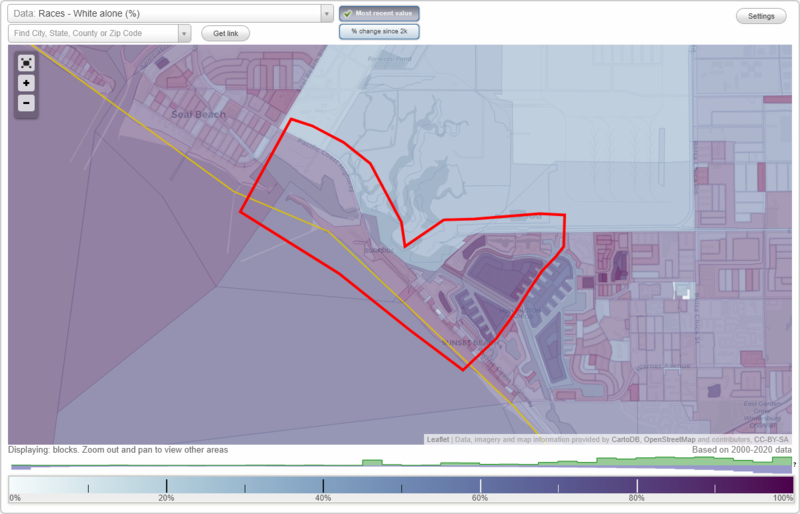
Surfside neighborhood in Seal Beach, California (CA), 90742, 90743, 90740, 92649 detailed profile
Settings
X

Business Search - 14 Million verified businesses
Area: 1.871 square miles
Population: 3,336
Population density:
| Surfside: | 1,783 people per square mile |
| Seal Beach: | 2,177 people per square mile |

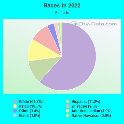
- 2,29761.7%White
- 41611.2%Hispanic or Latino
- 39110.5%Asian
- 3529.5%Two or more races
- 1283.4%Some other race
- 691.9%American Indian
- 381.0%Black
- 330.9%Native Hawaiian and Other
Pacific Islander
Distribution of median household income
![Distribution of median household income]()
- 99Less than $10,000
- 176$10,000 to $19,999
- 56$20,000 to $29,999
- 122$30,000 to $39,999
- 77$40,000 to $49,999
- 27$50,000 to $59,999
- 87$60,000 to $74,999
- 332$75,000 to $99,999
- 220$100,000 to $124,999
- 141$125,000 to $149,999
- 202$150,000 to $199,999
- 603$200,000 or more

Distribution of owner-occupied house/condo value
![Distribution of owner-occupied house/condo value]()
- 225Less than $50,000
- 80$50,000 to $99,999
- 186$100,000 to $149,999
- 44$150,000 to $199,999
- 93$200,000 to $249,999
- 322$250,000 to $299,999
- 274$300,000 to $399,999
- 472$400,000 to $499,999
- 191$500,000 to $749,999
- 374$750,000 to $999,999
- 1,320$1,000,000 or more

Distribution of rent paid by renters
![Distribution of rent paid by renters]()
- 8$600 to $699
- 45$700 to $799
- 7$800 to $899
- 12$1,000 to $1,249
- 44$1,250 to $1,499
- 61$1,500 to $1,999
- 378$2,000 or more

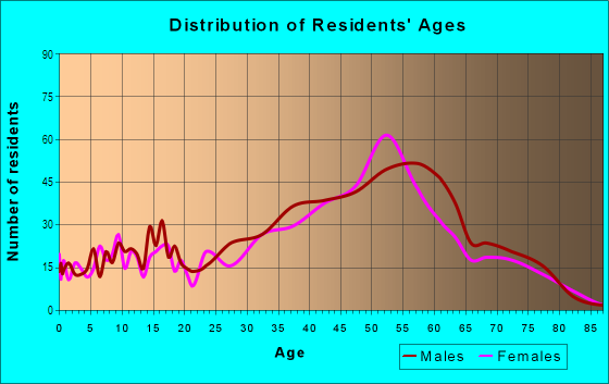
| Males: | 1,661 |
| Females: | 1,675 |
Males:
| This neighborhood: | 58.2 years |
| Whole city: | 56.9 years |
| This neighborhood: | 57.5 years |
| Whole city: | 64.2 years |
Average household size:
| Surfside: | 2.0 people |
| Seal Beach: | 1.9 people |
Percentage of family households:
| Surfside: | 30.8% |
| Seal Beach: | 22.0% |
| Here: | 56.4% |
| Seal Beach: | 38.7% |
Percentage of married-couple families with children (among all households):
| Surfside: | 41.8% |
| Seal Beach: | 43.4% |
Percentage of single-mother households (among all households):
| Surfside: | 11.5% |
| Seal Beach: | 6.6% |
Percentage of never married males 15 years old and over:
Percentage of never married females 15 years old and over:
| Surfside: | 9.2% |
| Seal Beach: | 10.6% |
Percentage of never married females 15 years old and over:
| Surfside: | 8.5% |
| city: | 11.4% |
Percentage of people that speak English not well or not at all:
| Surfside: | 2.4% |
| Seal Beach: | 3.9% |
Percentage of people born in this state:
Percentage of people born in another U.S. state:
Percentage of native residents but born outside the U.S.:
Percentage of foreign born residents:
| Here: | 60.5% |
| Seal Beach: | 51.3% |
Percentage of people born in another U.S. state:
| Surfside: | 24.5% |
| Seal Beach: | 30.7% |
Percentage of native residents but born outside the U.S.:
| Here: | 1.6% |
| city: | 0.7% |
Percentage of foreign born residents:
| Here: | 14.0% |
| Seal Beach: | 17.3% |
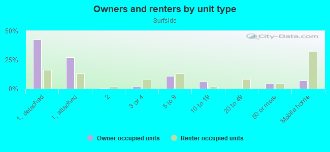
Owner-occupied
Renter-occupied

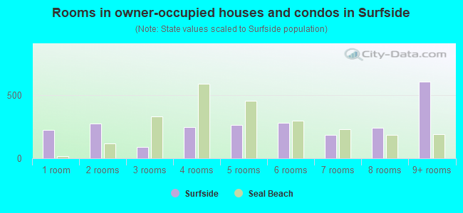
- Rooms in owner-occupied houses and condos in Surfside
- 2251 room
- 2782 rooms
- 903 rooms
- 2494 rooms
- 2655 rooms
- 2826 rooms
- 1877 rooms
- 2438 rooms
- 6109+ rooms
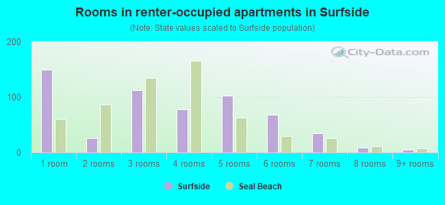
- Rooms in renter-occupied apartments in Surfside
- 1491 room
- 262 rooms
- 1123 rooms
- 784 rooms
- 1035 rooms
- 686 rooms
- 347 rooms
- 98 rooms
- 59+ rooms
Owner-occupied
Renter-occupied
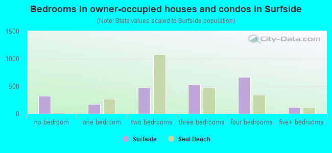
- Bedrooms in owner-occupied houses and condos in Surfside
- 322no bedroom
- 1771 bedroom
- 4732 bedrooms
- 5373 bedrooms
- 6654 bedrooms
- 1195+ bedrooms
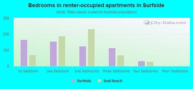
- Bedrooms in renter-occupied apartments in Surfside
- 167no bedroom
- 1551 bedroom
- 1262 bedrooms
- 1143 bedrooms
- 344 bedrooms
- 05+ bedrooms
Average number of cars or other vehicles available in houses/condos:
Average number of cars or other vehicles available in apartments:
| This neighborhood: | |
| Seal Beach: |
Average number of cars or other vehicles available in apartments:
| Here: | 1.5 |
| city: | 1.4 |
Percentage of units with a mortgage:
| Surfside: | 66.7% |
| Seal Beach: | 32.5% |
Average estimated value of detached houses in 2022 (54.5% of all units):
| Surfside: | $2,582,205 |
| Seal Beach: | $1,349,164 |
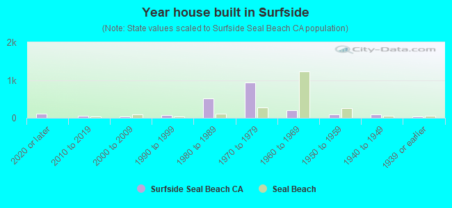
- Year house built in Surfside
- 1032020 or later
- 472010 to 2019
- 342000 to 2009
- 681990 to 1999
- 5161980 to 1989
- 9361970 to 1979
- 2111960 to 1969
- 951950 to 1959
- 991940 to 1949
- 431939 or earlier
City-data.com crime index for city in 2020 (higher means more crime):
| City: | 148.8 |
| U.S. average: | 219.5 |
Travel time to work (commute)
![Travel time to work (commute)]()
- 29Less than 5 minutes
- 1135 to 9 minutes
- 11010 to 14 minutes
- 14915 to 19 minutes
- 19620 to 24 minutes
- 9825 to 29 minutes
- 27330 to 34 minutes
- 11035 to 39 minutes
- 11540 to 44 minutes
- 30345 to 59 minutes
- 13060 to 89 minutes
- 4090 or more minutes

Means of transportation to work
![Means of transportation to work]()
- 73.6%1,130Drove a car alone
- 10.9%167Carpooled
- 0.3%4Bus
- 0.1%1Motorcycle
- 8.0%123Bicycle
- 0.4%6Walked
- 1.4%21Other means
- 16.8%258Worked at home

Time leaving home to go to work
![Time leaving home to go to work]()
- 3212:00 a.m. to 4:59 a.m.
- 805:00 a.m. to 5:29 a.m.
- 1315:30 a.m. to 5:59 a.m.
- 1056:00 a.m. to 6:29 a.m.
- 1686:30 a.m. to 6:59 a.m.
- 3067:00 a.m. to 7:29 a.m.
- 1377:30 a.m. to 7:59 a.m.
- 2068:00 a.m. to 8:29 a.m.
- 1478:30 a.m. to 8:59 a.m.
- 1529:00 a.m. to 9:59 a.m.
- 4610:00 a.m. to 10:59 a.m.
- 3211:00 a.m. to 11:59 a.m.
- 11312:00 p.m. to 3:59 p.m.
- 514:00 p.m. to 11:59 p.m.

Occupations of males:
- Percentage of males in management occupations (except farmers):
Here: 26.9% city: 18.9%
- Percentage of males in business and financial operations occupations:
Here: 5.2% city: 8.6%
- Percentage of males in computer and mathematical occupations:
Here: 3.1% city: 3.0%
- Percentage of males in architecture and engineering occupations:
Here: 7.6% city: 6.1%
- Percentage of males in life, physical, and social science occupations:
Here: 1.5% city: 1.7%
- Percentage of males in legal occupations:
Here: 1.5% city: 4.5%
- Percentage of males in education, training, and library occupations:
Here: 7.2% city: 4.8%
- Percentage of males in arts, design, entertainment, sports, and media occupations:
Here: 6.4% city: 2.9%
- Percentage of males in healthcare practitioners and technical occupations:
Here: 4.1% city: 7.4%
- Percentage of males in service occupations:
Here: 10.4% city: 7.6%
- Percentage of males in sales and office occupations:
Here: 16.4% city: 17.8%
- Percentage of males in construction, extraction, and maintenance occupations:
Here: 3.9% city: 5.4%
- Percentage of males in production occupations:
Here: 1.1% city: 2.1%
- Percentage of males in material moving occupations:
Here: 3.6% city: 0.5%
Occupations of females:
- Percentage of females in management occupations (except farmers):
Here: 14.9% city: 13.2%
- Percentage of females in business and financial operations occupations:
Here: 6.2% city: 9.2%
- Percentage of females in community and social services occupations:
Here: 6.2% city: 3.7%
- Percentage of females in education, training, and library occupations:
Here: 9.4% city: 16.6%
- Percentage of females in arts, design, entertainment, sports, and media occupations:
Here: 3.4% city: 1.4%
- Percentage of females in healthcare practitioners and technical occupations:
Here: 8.0% city: 9.3%
- Percentage of females in service occupations:
Here: 7.5% city: 12.9%
- Percentage of females in sales and office occupations:
Here: 29.5% city: 25.5%
- Percentage of females in farming, fishing, and forestry occupations:
Here: 1.8% city: 0.0%
- Percentage of females in production occupations:
Here: 8.9% city: 0.0%
- Percentage of females in transportation occupations:
Here: 1.6% city: 0.9%
- Percentage of females in material moving occupations:
Here: 1.3% city: 0.6%
Percentage of people 16-64 in Armed Forces:
| Surfside: | 0.5% |
| Seal Beach: | 1.6% |
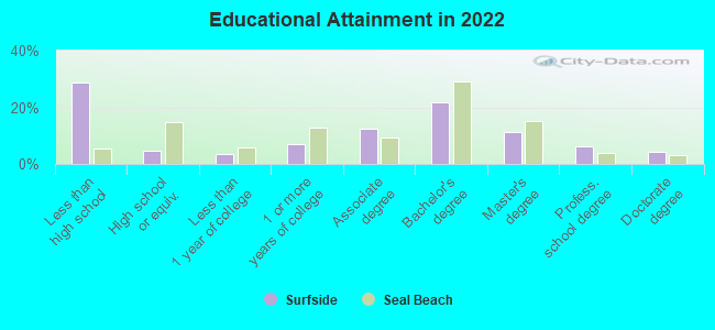
Education in this neighborhood (subdivision or community):
- Percentage of people 3 years and older in K-12 schools:
Surfside: 11.6% Seal Beach: 10.7%
- Percentage of people 3 years and older in undergraduate colleges:
Surfside: 3.5% Seal Beach: 2.9%
- Percentage of people 3 years and older in grad. or professional schools:
Surfside: 5.1% Seal Beach: 1.4%
- Percentage of students K-12 enrolled in private schools:
Surfside: 261.8% Seal Beach: 9.3%
Percentage of population below poverty level:
| Surfside: | 6.0% |
| Seal Beach: | 6.2% |
Percentage of married-couple families with both working:
| Surfside: | 73.7% |
| Seal Beach: | 77.4% |
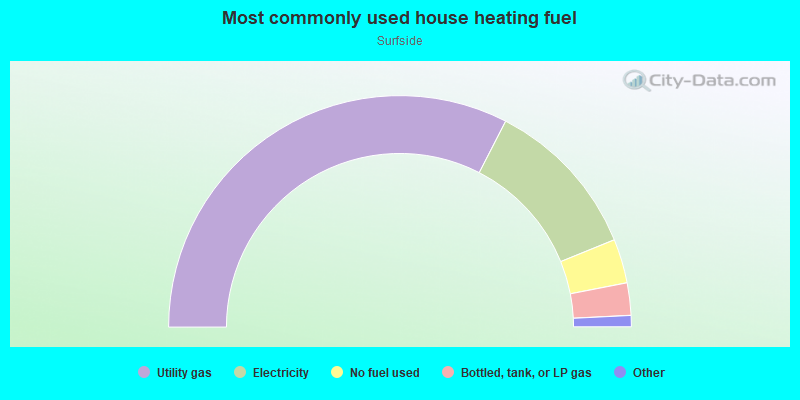
- 65.1%Utility gas
- 22.6%Electricity
- 6.2%No fuel used
- 4.5%Bottled, tank, or LP gas
- 0.8%Wood
- 0.8%Solar energy
Highways in this neighborhood:
State Hwy 1 (Pacific Coast Hwy)
Length: 2.52 miles
Directions: E-W, N-S, SE-NW, SW-NE
Address range: 1826 to 16912
Directions: E-W, N-S, SE-NW, SW-NE
Address range: 1826 to 16912
Roads and streets:
Pacific Ave
Length: 1.11 miles
Directions: E-W, SE-NW
Address range: 1999 to 16882
Directions: E-W, SE-NW
Address range: 1999 to 16882
Edinger Ave
Length: 0.71 miles
Direction: E-W
Direction: E-W
Surfside Ave
Length: 0.67 miles
Directions: E-W, N-S, SE-NW, SW-NE
Directions: E-W, N-S, SE-NW, SW-NE
Ocean Ave
Length: 0.50 miles
Direction: SE-NW
Address range: 1601 to 16875
Direction: SE-NW
Address range: 1601 to 16875
Channel Ln
Length: 0.41 miles
Directions: E-W, N-S, SE-NW, SW-NE
Address range: 16500 to 16899
Directions: E-W, N-S, SE-NW, SW-NE
Address range: 16500 to 16899
Venture Dr
Length: 0.41 miles
Directions: E-W, SE-NW
Address range: 3200 to 3799
Directions: E-W, SE-NW
Address range: 3200 to 3799
Park Circle Dr
Length: 0.40 miles
Directions: E-W, N-S
Directions: E-W, N-S
Aquarius Dr
Length: 0.39 miles
Directions: E-W, SE-NW, SW-NE
Address range: 3400 to 3759
Directions: E-W, SE-NW, SW-NE
Address range: 3400 to 3759
Signal Rd
Length: 0.36 miles
Directions: E-W, N-S, SW-NE
Directions: E-W, N-S, SW-NE
Sundancer Ln
Length: 0.32 miles
Directions: N-S, SW-NE
Address range: 16200 to 16499
Directions: N-S, SW-NE
Address range: 16200 to 16499
Sagamore Dr
Length: 0.31 miles
Directions: E-W, SE-NW, SW-NE
Address range: 3400 to 3699
Directions: E-W, SE-NW, SW-NE
Address range: 3400 to 3699
Windspun Dr
Length: 0.29 miles
Directions: E-W, SE-NW, SW-NE
Address range: 3400 to 3659
Directions: E-W, SE-NW, SW-NE
Address range: 3400 to 3659
Trinidad Ln
Length: 0.28 miles
Directions: N-S, SE-NW, SW-NE
Address range: 16000 to 16399
Directions: N-S, SE-NW, SW-NE
Address range: 16000 to 16399
Sparkler Dr
Length: 0.27 miles
Directions: E-W, N-S, SW-NE
Address range: 3200 to 3499
Directions: E-W, N-S, SW-NE
Address range: 3200 to 3499
Mariner Dr
Length: 0.26 miles
Direction: SE-NW
Address range: 15926 to 19599
Direction: SE-NW
Address range: 15926 to 19599
Bayview Dr
Length: 0.26 miles
Direction: SE-NW
Address range: 16599 to 16899
Direction: SE-NW
Address range: 16599 to 16899
Bravata Dr
Length: 0.26 miles
Direction: E-W
Address range: 3400 to 3699
Direction: E-W
Address range: 3400 to 3699
Grimaud Ln
Length: 0.25 miles
Directions: N-S, SE-NW, SW-NE
Address range: 16350 to 16599
Directions: N-S, SE-NW, SW-NE
Address range: 16350 to 16599
Somerset Ln
Length: 0.24 miles
Directions: E-W, SE-NW, SW-NE
Address range: 16476 to 16699
Directions: E-W, SE-NW, SW-NE
Address range: 16476 to 16699
Admiralty Dr
Length: 0.24 miles
Direction: SW-NE
Address range: 3100 to 3399
Direction: SW-NE
Address range: 3100 to 3399
Montego Dr
Length: 0.24 miles
Directions: E-W, N-S, SW-NE
Address range: 3600 to 4051
Directions: E-W, N-S, SW-NE
Address range: 3600 to 4051
Gilbert Dr
Length: 0.23 miles
Direction: SW-NE
Address range: 3200 to 3599
Direction: SW-NE
Address range: 3200 to 3599
Peale Ln
Length: 0.23 miles
Directions: N-S, SE-NW, SW-NE
Address range: 16475 to 16799
Directions: N-S, SE-NW, SW-NE
Address range: 16475 to 16799
Countess Dr
Length: 0.22 miles
Directions: N-S, SW-NE
Address range: 3200 to 16299
Directions: N-S, SW-NE
Address range: 3200 to 16299
Seascape Dr
Length: 0.21 miles
Directions: E-W, SE-NW
Address range: 3600 to 3899
Directions: E-W, SE-NW
Address range: 3600 to 3899
Portofino Cir
Length: 0.21 miles
Directions: E-W, N-S, SE-NW, SW-NE
Address range: 3100 to 3299
Directions: E-W, N-S, SE-NW, SW-NE
Address range: 3100 to 3299
Bordeaux Ln
Length: 0.20 miles
Directions: E-W, N-S, SE-NW, SW-NE
Address range: 16448 to 16649
Directions: E-W, N-S, SE-NW, SW-NE
Address range: 16448 to 16649
Intrepid Ln
Length: 0.19 miles
Directions: E-W, SE-NW, SW-NE
Address range: 16600 to 16799
Directions: E-W, SE-NW, SW-NE
Address range: 16600 to 16799
Tortola Cir
Length: 0.19 miles
Directions: E-W, N-S
Address range: 16050 to 16299
Directions: E-W, N-S
Address range: 16050 to 16299
Bimini Ln
Length: 0.19 miles
Directions: E-W, N-S, SE-NW
Address range: 16000 to 16249
Directions: E-W, N-S, SE-NW
Address range: 16000 to 16249
Moritz Dr
Length: 0.17 miles
Directions: E-W, N-S, SE-NW, SW-NE
Address range: 3179 to 3307
Directions: E-W, N-S, SE-NW, SW-NE
Address range: 3179 to 3307
Tempe Dr
Length: 0.17 miles
Directions: E-W, SW-NE
Address range: 3244 to 3399
Directions: E-W, SW-NE
Address range: 3244 to 3399
Anderson St
Length: 0.15 miles
Direction: SW-NE
Address range: 1 to 16499
Direction: SW-NE
Address range: 1 to 16499
Tropez Ln
Length: 0.15 miles
Directions: N-S, SE-NW, SW-NE
Address range: 16400 to 17650
Directions: N-S, SE-NW, SW-NE
Address range: 16400 to 17650
Broadway
Length: 0.14 miles
Directions: N-S, SE-NW, SW-NE
Address range: 16676 to 16774
Directions: N-S, SE-NW, SW-NE
Address range: 16676 to 16774
Lazare Ln
Length: 0.12 miles
Directions: E-W, N-S, SE-NW, SW-NE
Address range: 16400 to 16499
Directions: E-W, N-S, SE-NW, SW-NE
Address range: 16400 to 16499
Running Tide Cir
Length: 0.12 miles
Direction: SE-NW
Address range: 3500 to 3649
Direction: SE-NW
Address range: 3500 to 3649
Piedmont Cir
Length: 0.12 miles
Directions: E-W, SE-NW, SW-NE
Address range: 16200 to 16299
Directions: E-W, SE-NW, SW-NE
Address range: 16200 to 16299
Wellington Cir
Length: 0.11 miles
Directions: E-W, SE-NW, SW-NE
Address range: 16500 to 16699
Directions: E-W, SE-NW, SW-NE
Address range: 16500 to 16699
Francois Dr
Length: 0.11 miles
Directions: E-W, SE-NW
Address range: 3170 to 3299
Directions: E-W, SE-NW
Address range: 3170 to 3299
Typhoon Ln
Length: 0.11 miles
Directions: N-S, SE-NW, SW-NE
Address range: 16100 to 16399
Directions: N-S, SE-NW, SW-NE
Address range: 16100 to 16399
Spartan Cir
Length: 0.11 miles
Directions: N-S, SW-NE
Address range: 16248 to 16399
Directions: N-S, SW-NE
Address range: 16248 to 16399
Walrus Ln
Length: 0.11 miles
Direction: SW-NE
Address range: 16200 to 16399
Direction: SW-NE
Address range: 16200 to 16399
Rebel Cir
Length: 0.10 miles
Direction: SE-NW
Address range: 3500 to 3759
Direction: SE-NW
Address range: 3500 to 3759
Surprise Ln
Length: 0.09 miles
Directions: E-W, N-S, SE-NW, SW-NE
Address range: 16000 to 16099
Directions: E-W, N-S, SE-NW, SW-NE
Address range: 16000 to 16099
Martin Ln
Length: 0.09 miles
Directions: E-W, N-S, SW-NE
Address range: 16300 to 16450
Directions: E-W, N-S, SW-NE
Address range: 16300 to 16450
Saint Croix Cir
Length: 0.09 miles
Directions: E-W, N-S
Address range: 16050 to 16199
Directions: E-W, N-S
Address range: 16050 to 16199
Bonaire Cir
Length: 0.09 miles
Directions: E-W, N-S
Address range: 16000 to 16149
Directions: E-W, N-S
Address range: 16000 to 16149
Grenoble Ln
Length: 0.09 miles
Directions: E-W, SE-NW, SW-NE
Address range: 16327 to 16357
Directions: E-W, SE-NW, SW-NE
Address range: 16327 to 16357
16th St
Length: 0.09 miles
Directions: N-S, SW-NE
Address range: 16713 to 16899
Directions: N-S, SW-NE
Address range: 16713 to 16899
Pirate Cir
Length: 0.09 miles
Direction: SE-NW
Address range: 3600 to 3759
Direction: SE-NW
Address range: 3600 to 3759
Anderson
Length: 0.08 miles
Directions: E-W, SE-NW, SW-NE
Directions: E-W, SE-NW, SW-NE
Bounty Cir
Length: 0.08 miles
Directions: N-S, SE-NW, SW-NE
Address range: 3279 to 3356
Directions: N-S, SE-NW, SW-NE
Address range: 3279 to 3356
Wildfire Cir
Length: 0.08 miles
Direction: N-S
Address range: 16248 to 16399
Direction: N-S
Address range: 16248 to 16399
25th St
Length: 0.07 miles
Direction: SW-NE
Address range: 16401 to 16599
Direction: SW-NE
Address range: 16401 to 16599
Rascal Ln
Length: 0.07 miles
Directions: N-S, SW-NE
Address range: 16200 to 16399
Directions: N-S, SW-NE
Address range: 16200 to 16399
24th St
Length: 0.07 miles
Direction: SW-NE
Address range: 16400 to 16599
Direction: SW-NE
Address range: 16400 to 16599
Devon Cir
Length: 0.07 miles
Direction: SW-NE
Address range: 3200 to 3399
Direction: SW-NE
Address range: 3200 to 3399
23rd St
Length: 0.07 miles
Direction: SW-NE
Address range: 16400 to 16699
Direction: SW-NE
Address range: 16400 to 16699
Melville Cir
Length: 0.07 miles
Direction: SE-NW
Address range: 16500 to 16699
Direction: SE-NW
Address range: 16500 to 16699
26th St
Length: 0.07 miles
Direction: SW-NE
Address range: 16300 to 16499
Direction: SW-NE
Address range: 16300 to 16499
Bandit Cir
Length: 0.07 miles
Direction: E-W
Address range: 3300 to 3399
Direction: E-W
Address range: 3300 to 3399
Tiburon Pl
Length: 0.06 miles
Directions: N-S, SE-NW
Address range: 16500 to 16699
Directions: N-S, SE-NW
Address range: 16500 to 16699
Alert Ln
Length: 0.06 miles
Directions: E-W, N-S, SE-NW, SW-NE
Address range: 16150 to 16199
Directions: E-W, N-S, SE-NW, SW-NE
Address range: 16150 to 16199
Malden Cir
Length: 0.06 miles
Direction: SE-NW
Address range: 16430 to 16477
Direction: SE-NW
Address range: 16430 to 16477
Aruba Cir
Length: 0.06 miles
Direction: E-W
Address range: 3845 to 3999
Direction: E-W
Address range: 3845 to 3999
15th St
Length: 0.06 miles
Direction: SW-NE
Address range: 16700 to 16899
Direction: SW-NE
Address range: 16700 to 16899
11th St
Length: 0.06 miles
Direction: SW-NE
Address range: 16800 to 17099
Direction: SW-NE
Address range: 16800 to 17099
12th St
Length: 0.06 miles
Direction: SW-NE
Address range: 16800 to 16999
Direction: SW-NE
Address range: 16800 to 16999
Mariana Cir
Length: 0.06 miles
Direction: SE-NW
Address range: 16500 to 16578
Direction: SE-NW
Address range: 16500 to 16578
Contender Ln
Length: 0.06 miles
Directions: N-S, SE-NW
Address range: 16034 to 16099
Directions: N-S, SE-NW
Address range: 16034 to 16099
22nd St
Length: 0.06 miles
Direction: SW-NE
Address range: 16400 to 16699
Direction: SW-NE
Address range: 16400 to 16699
14th St
Length: 0.06 miles
Direction: SW-NE
Address range: 16700 to 16999
Direction: SW-NE
Address range: 16700 to 16999
Phillips St
Length: 0.05 miles
Direction: SW-NE
Address range: 100 to 199
Direction: SW-NE
Address range: 100 to 199
Kitts Hwy
Length: 0.05 miles
Direction: SW-NE
Direction: SW-NE
17th St
Length: 0.05 miles
Direction: SW-NE
Address range: 16700 to 16899
Direction: SW-NE
Address range: 16700 to 16899
Easter Cir
Length: 0.05 miles
Direction: SW-NE
Address range: 3247 to 3324
Direction: SW-NE
Address range: 3247 to 3324
Dominica Cir
Length: 0.05 miles
Directions: E-W, N-S
Address range: 16000 to 16099
Directions: E-W, N-S
Address range: 16000 to 16099
Vim Ln
Length: 0.05 miles
Direction: N-S
Direction: N-S
Falkland Cir
Length: 0.04 miles
Direction: SW-NE
Address range: 3200 to 3399
Direction: SW-NE
Address range: 3200 to 3399
Escapade Cir
Length: 0.04 miles
Direction: SE-NW
Address range: 3600 to 3799
Direction: SE-NW
Address range: 3600 to 3799
21st St
Length: 0.04 miles
Direction: SW-NE
Address range: 16500 to 16699
Direction: SW-NE
Address range: 16500 to 16699
18th St
Length: 0.04 miles
Direction: SW-NE
Address range: 16600 to 16799
Direction: SW-NE
Address range: 16600 to 16799
Remora Dr
Length: 0.04 miles
Directions: N-S, SE-NW
Address range: 3150 to 3219
Directions: N-S, SE-NW
Address range: 3150 to 3219
Nimble Cir
Length: 0.04 miles
Direction: SE-NW
Address range: 3700 to 3799
Direction: SE-NW
Address range: 3700 to 3799
19th St
Length: 0.04 miles
Direction: SW-NE
Address range: 16600 to 16799
Direction: SW-NE
Address range: 16600 to 16799
20th St
Length: 0.04 miles
Direction: SW-NE
Address range: 16500 to 16699
Direction: SW-NE
Address range: 16500 to 16699
Ragtime Cir
Length: 0.04 miles
Direction: SE-NW
Address range: 3700 to 3899
Direction: SE-NW
Address range: 3700 to 3899
Quickstep Cir
Length: 0.04 miles
Directions: E-W, SW-NE
Address range: 3400 to 3451
Directions: E-W, SW-NE
Address range: 3400 to 3451
Content Cir
Length: 0.04 miles
Directions: N-S, SE-NW
Address range: 16248 to 16349
Directions: N-S, SE-NW
Address range: 16248 to 16349
Germain Cir
Length: 0.04 miles
Direction: N-S
Address range: 16435 to 16498
Direction: N-S
Address range: 16435 to 16498
Pacific Cir
Length: 0.04 miles
Directions: E-W, SE-NW
Address range: 16200 to 16299
Directions: E-W, SE-NW
Address range: 16200 to 16299
Twinkle Cir
Length: 0.04 miles
Directions: E-W, N-S, SE-NW
Address range: 16100 to 16151
Directions: E-W, N-S, SE-NW
Address range: 16100 to 16151
Sea Way
Length: 0.03 miles
Direction: SW-NE
Address range: 100 to 199
Direction: SW-NE
Address range: 100 to 199
Fame Cir
Length: 0.03 miles
Direction: N-S
Address range: 16000 to 16199
Direction: N-S
Address range: 16000 to 16199
Anne Cir
Length: 0.02 miles
Direction: SE-NW
Address range: 3100 to 3299
Direction: SE-NW
Address range: 3100 to 3299
Case Rd
Length: 0.02 miles
Direction: SW-NE
Direction: SW-NE
Railroad features:
Union Pacific RR
Length: 0.18 miles
Direction: SW-NE
Direction: SW-NE
Other features:
Sunset Way E
Length: 0.85 miles
Directions: E-W, N-S, SE-NW, SW-NE
Directions: E-W, N-S, SE-NW, SW-NE