The Tent City (Tent City) neighborhood in San Diego, California (CA), 92118, 92135, 91932 detailed profile
Settings
X


Business Search - 14 Million verified businesses
Area: 22.495 square miles
Population: 87,380
Population density:
| The Tent City (Tent City): | 3,885 people per square mile |
| San Diego: | 4,258 people per square mile |

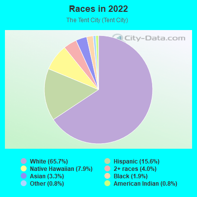
- 63,95365.7%White
- 15,18115.6%Hispanic or Latino
- 7,7087.9%Native Hawaiian and Other
Pacific Islander - 3,9314.0%Two or more races
- 3,2103.3%Asian
- 1,8211.9%Black
- 7500.8%American Indian
- 7780.8%Some other race
Median household income in 2022:
| The Tent City (Tent City): | $117,402 |
| San Diego: | $100,010 |
Distribution of median household income
![Distribution of median household income]()
- 1,402Less than $10,000
- 2,083$10,000 to $19,999
- 7,699$20,000 to $29,999
- 1,971$30,000 to $39,999
- 2,003$40,000 to $49,999
- 1,946$50,000 to $59,999
- 2,071$60,000 to $74,999
- 3,556$75,000 to $99,999
- 5,214$100,000 to $124,999
- 2,963$125,000 to $149,999
- 4,885$150,000 to $199,999
- 8,950$200,000 or more

Distribution of owner-occupied house/condo value
![Distribution of owner-occupied house/condo value]()
- 2,866Less than $50,000
- 772$50,000 to $99,999
- 1,544$100,000 to $149,999
- 1,697$150,000 to $199,999
- 1,047$200,000 to $249,999
- 59$300,000 to $399,999
- 918$400,000 to $499,999
- 4,682$500,000 to $749,999
- 3,069$750,000 to $999,999
- 14,680$1,000,000 or more

Distribution of rent paid by renters
![Distribution of rent paid by renters]()
- 1,400$300 to $399
- 1,317$500 to $599
- 3,463$700 to $799
- 3,223$800 to $899
- 5,541$900 to $999
- 2,571$1,000 to $1,249
- 4,871$1,250 to $1,499
- 6,725$1,500 to $1,999
- 25,416$2,000 or more

Median rent in 2022:
| The Tent City (Tent City): | $2,765 |
| San Diego: | $1,971 |
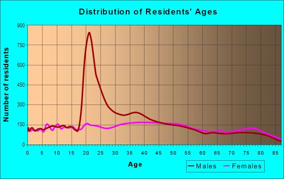
| Males: | 44,319 |
| Females: | 43,061 |
Males:
| This neighborhood: | 43.6 years |
| Whole city: | 35.4 years |
| This neighborhood: | 46.1 years |
| Whole city: | 37.2 years |
Average household size:
| The Tent City (Tent City): | 5.4 people |
| San Diego: | 2.5 people |
Percentage of family households:
| The Tent City (Tent City): | 43.2% |
| San Diego: | 41.7% |
| Here: | 54.2% |
| San Diego: | 43.2% |
Percentage of married-couple families with children (among all households):
| The Tent City (Tent City): | 33.6% |
| San Diego: | 27.8% |
Percentage of single-mother households (among all households):
| The Tent City (Tent City): | 15.5% |
| San Diego: | 7.9% |
Percentage of never married males 15 years old and over:
Percentage of never married females 15 years old and over:
| The Tent City (Tent City): | 14.1% |
| San Diego: | 23.4% |
Percentage of never married females 15 years old and over:
| The Tent City (Tent City): | 10.8% |
| city: | 18.8% |
Percentage of people that speak English not well or not at all:
| The Tent City (Tent City): | 1.0% |
| San Diego: | 5.9% |
Percentage of people born in this state:
Percentage of people born in another U.S. state:
Percentage of native residents but born outside the U.S.:
Percentage of foreign born residents:
| Here: | 39.2% |
| San Diego: | 48.1% |
Percentage of people born in another U.S. state:
| The Tent City (Tent City): | 48.9% |
| San Diego: | 24.9% |
Percentage of native residents but born outside the U.S.:
| Here: | 2.3% |
| city: | 2.4% |
Percentage of foreign born residents:
| Here: | 9.7% |
| San Diego: | 24.6% |
Owner-occupied
Renter-occupied

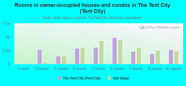
- Rooms in owner-occupied houses and condos in The Tent City <
> - 01 room
- 2,6402 rooms
- 1,4743 rooms
- 2,9034 rooms
- 3,0805 rooms
- 4,9166 rooms
- 2,3577 rooms
- 1,9378 rooms
- 2,6719+ rooms
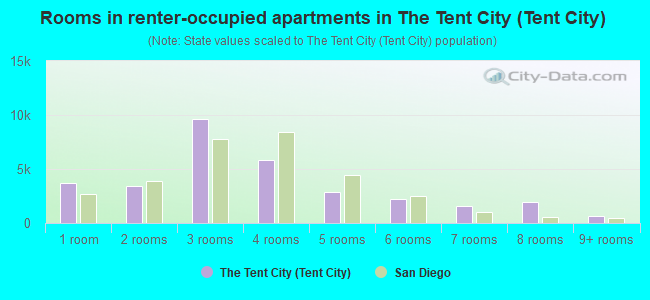
- Rooms in renter-occupied apartments in The Tent City <
> - 3,7181 room
- 3,4242 rooms
- 9,6663 rooms
- 5,8284 rooms
- 2,8695 rooms
- 2,2036 rooms
- 1,5357 rooms
- 1,9538 rooms
- 6109+ rooms
Owner-occupied
Renter-occupied
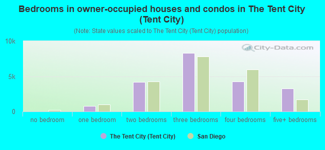
- Bedrooms in owner-occupied houses and condos in The Tent City <
> - 0no bedroom
- 7911 bedroom
- 4,2142 bedrooms
- 8,3173 bedrooms
- 4,2824 bedrooms
- 3,2465+ bedrooms
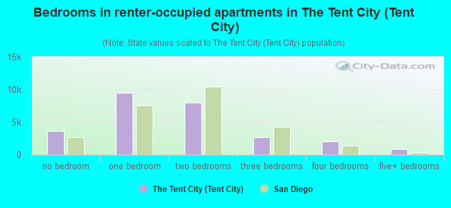
- Bedrooms in renter-occupied apartments in The Tent City <
> - 3,567no bedroom
- 9,4981 bedroom
- 7,9632 bedrooms
- 2,6833 bedrooms
- 2,0584 bedrooms
- 8115+ bedrooms
Average number of cars or other vehicles available in houses/condos:
Average number of cars or other vehicles available in apartments:
| This neighborhood: | 2.0 |
| San Diego: | 2.1 |
Average number of cars or other vehicles available in apartments:
| Here: | 1.7 |
| city: | 1.6 |
Percentage of units with a mortgage:
| The Tent City (Tent City): | 59.9% |
| San Diego: | 69.2% |
Average estimated value of detached houses in 2022 (55.2% of all units):
| The Tent City (Tent City): | $2,490,908 |
| San Diego: | $1,227,596 |
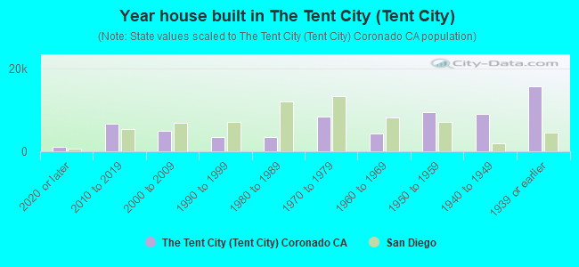
- Year house built in The Tent City <
> - 1,1032020 or later
- 6,7402010 to 2019
- 4,9452000 to 2009
- 3,4591990 to 1999
- 3,5161980 to 1989
- 8,4731970 to 1979
- 4,3941960 to 1969
- 9,5191950 to 1959
- 9,0281940 to 1949
- 15,5941939 or earlier
City-data.com crime index for city in 2020 (higher means more crime):
| City: | 197.8 |
| U.S. average: | 219.5 |
Travel time to work (commute)
![Travel time to work (commute)]()
- 315Less than 5 minutes
- 2,7105 to 9 minutes
- 2,62810 to 14 minutes
- 3,00015 to 19 minutes
- 3,36420 to 24 minutes
- 96725 to 29 minutes
- 2,26630 to 34 minutes
- 40335 to 39 minutes
- 54040 to 44 minutes
- 2,95645 to 59 minutes
- 48360 to 89 minutes
- 41790 or more minutes

Means of transportation to work
![Means of transportation to work]()
- 61.0%24,023Drove a car alone
- 8.5%3,363Carpooled
- 6.3%2,479Bus
- 3.1%1,224Long-distance train or commuter rail
- 3.5%1,397Light rail, streetcar or trolley
- 3.9%1,543Ferryboat
- 2.2%874Taxi
- 1.2%464Motorcycle
- 10.9%4,298Bicycle
- 11.2%4,405Walked
- 2.1%823Other means
- 21.0%8,277Worked at home

Time leaving home to go to work
![Time leaving home to go to work]()
- 87512:00 a.m. to 4:59 a.m.
- 2,2215:00 a.m. to 5:29 a.m.
- 1,8565:30 a.m. to 5:59 a.m.
- 2,2716:00 a.m. to 6:29 a.m.
- 1,6366:30 a.m. to 6:59 a.m.
- 1,9897:00 a.m. to 7:29 a.m.
- 2,0067:30 a.m. to 7:59 a.m.
- 1,4698:00 a.m. to 8:29 a.m.
- 7378:30 a.m. to 8:59 a.m.
- 2,3979:00 a.m. to 9:59 a.m.
- 86210:00 a.m. to 10:59 a.m.
- 10211:00 a.m. to 11:59 a.m.
- 1,16112:00 p.m. to 3:59 p.m.
- 6354:00 p.m. to 11:59 p.m.

Occupations of males:
- Percentage of males in management occupations (except farmers):
Here: 21.9% city: 12.7%
- Percentage of males in business and financial operations occupations:
Here: 7.9% city: 6.6%
- Percentage of males in computer and mathematical occupations:
Here: 5.5% city: 8.8%
- Percentage of males in architecture and engineering occupations:
Here: 6.4% city: 6.5%
- Percentage of males in life, physical, and social science occupations:
Here: 1.7% city: 2.6%
- Percentage of males in community and social services occupations:
Here: 1.0% city: 1.0%
- Percentage of males in legal occupations:
Here: 3.6% city: 1.7%
- Percentage of males in education, training, and library occupations:
Here: 3.6% city: 3.8%
- Percentage of males in arts, design, entertainment, sports, and media occupations:
Here: 2.1% city: 2.9%
- Percentage of males in healthcare practitioners and technical occupations:
Here: 7.8% city: 3.8%
- Percentage of males in service occupations:
Here: 9.3% city: 14.6%
- Percentage of males in sales and office occupations:
Here: 13.1% city: 13.9%
- Percentage of males in construction, extraction, and maintenance occupations:
Here: 2.7% city: 5.9%
- Percentage of males in production occupations:
Here: 2.6% city: 4.6%
- Percentage of males in transportation occupations:
Here: 5.7% city: 3.9%
- Percentage of males in material moving occupations:
Here: 3.6% city: 3.3%
Occupations of females:
- Percentage of females in management occupations (except farmers):
Here: 15.2% city: 10.2%
- Percentage of females in business and financial operations occupations:
Here: 7.6% city: 9.0%
- Percentage of females in computer and mathematical occupations:
Here: 1.6% city: 3.3%
- Percentage of females in architecture and engineering occupations:
Here: 1.6% city: 1.7%
- Percentage of females in community and social services occupations:
Here: 1.4% city: 2.5%
- Percentage of females in legal occupations:
Here: 2.4% city: 1.8%
- Percentage of females in education, training, and library occupations:
Here: 12.6% city: 8.2%
- Percentage of females in arts, design, entertainment, sports, and media occupations:
Here: 4.9% city: 2.9%
- Percentage of females in healthcare practitioners and technical occupations:
Here: 7.9% city: 9.7%
- Percentage of females in service occupations:
Here: 13.4% city: 19.9%
- Percentage of females in sales and office occupations:
Here: 28.9% city: 22.0%
Percentage of people 16-64 in Armed Forces:
| The Tent City (Tent City): | 30.1% |
| San Diego: | 4.0% |
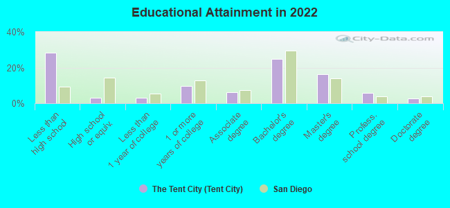
Education in this neighborhood (subdivision or community):
- Percentage of people 3 years and older in K-12 schools:
The Tent City (Tent City): 26.2% San Diego: 13.8%
- Percentage of people 3 years and older in undergraduate colleges:
The Tent City (Tent City): 5.6% San Diego: 8.5%
- Percentage of people 3 years and older in grad. or professional schools:
The Tent City (Tent City): 4.6% San Diego: 2.3%
- Percentage of students K-12 enrolled in private schools:
The Tent City (Tent City): 76.7% San Diego: 13.6%
Percentage of population below poverty level:
| The Tent City (Tent City): | 5.2% |
| San Diego: | 11.3% |
Median year renter moved in (as recorded in 2022):
| The Tent City (Tent City): | 2017 |
| San Diego: | 2020 |
Percentage of married-couple families with both working:
| The Tent City (Tent City): | 73.9% |
| San Diego: | 66.0% |
- 60.0%Utility gas
- 30.2%Electricity
- 4.0%No fuel used
- 2.4%Solar energy
- 1.3%Bottled, tank, or LP gas
- 1.3%Fuel oil, kerosene, etc.
- 0.9%Wood
Limited-access highways (interstate or state) in this neighborhood:
State Hwy 75
Length: 0.47 miles
Direction: SE-NW
Direction: SE-NW
Highways in this neighborhood:
State Hwy 75 (Silver Strand Blvd)
Length: 8.49 miles
Directions: E-W, N-S, SE-NW
Address range: 500 to 5714
Directions: E-W, N-S, SE-NW
Address range: 500 to 5714
Orange Ave (State Hwy 75)
Length: 1.57 miles
Directions: N-S, SE-NW, SW-NE
Address range: 100 to 1699
Directions: N-S, SE-NW, SW-NE
Address range: 100 to 1699
State Hwy 75 (Hwy 75, Silver Strand Blvd)
Length: 0.17 miles
Direction: SE-NW
Address range: 600 to 615
Direction: SE-NW
Address range: 600 to 615
Roads and streets:
Moffett Rd
Length: 4.15 miles
Directions: E-W, N-S, SE-NW, SW-NE
Directions: E-W, N-S, SE-NW, SW-NE
2nd St
Length: 2.82 miles
Directions: E-W, N-S, SE-NW, SW-NE
Address range: 300 to 2099
Directions: E-W, N-S, SE-NW, SW-NE
Address range: 300 to 2099
Rogers Rd
Length: 2.67 miles
Directions: E-W, N-S, SE-NW, SW-NE
Directions: E-W, N-S, SE-NW, SW-NE
4th St
Length: 2.18 miles
Directions: E-W, N-S, SE-NW
Address range: 300 to 1592
Directions: E-W, N-S, SE-NW
Address range: 300 to 1592
3rd St
Length: 2.17 miles
Directions: E-W, N-S, SE-NW
Address range: 300 to 1599
Directions: E-W, N-S, SE-NW
Address range: 300 to 1599
1st St
Length: 1.98 miles
Directions: E-W, SE-NW
Address range: 300 to 1599
Directions: E-W, SE-NW
Address range: 300 to 1599
Palm Ave
Length: 1.85 miles
Directions: E-W, N-S, SE-NW, SW-NE
Address range: 22 to 675
Directions: E-W, N-S, SE-NW, SW-NE
Address range: 22 to 675
Glorietta Blvd
Length: 1.66 miles
Directions: E-W, N-S, SE-NW, SW-NE
Address range: 300 to 1709
Directions: E-W, N-S, SE-NW, SW-NE
Address range: 300 to 1709
Hooper Blvd
Length: 1.59 miles
Directions: N-S, SE-NW, SW-NE
Directions: N-S, SE-NW, SW-NE
Mc Cain Blvd
Length: 1.49 miles
Directions: E-W, SE-NW
Directions: E-W, SE-NW
Alameda Blvd
Length: 1.48 miles
Directions: N-S, SE-NW, SW-NE
Address range: 84 to 1299
Directions: N-S, SE-NW, SW-NE
Address range: 84 to 1299
6th St
Length: 1.45 miles
Directions: E-W, SE-NW
Address range: 100 to 1699
Directions: E-W, SE-NW
Address range: 100 to 1699
Quentin Roosevelt Blvd
Length: 1.41 miles
Directions: N-S, SW-NE
Directions: N-S, SW-NE
Strand Way
Length: 1.37 miles
Directions: N-S, SE-NW, SW-NE
Address range: 1631 to 1849
Directions: N-S, SE-NW, SW-NE
Address range: 1631 to 1849
5th St
Length: 1.31 miles
Directions: E-W, N-S, SE-NW
Address range: 300 to 1599
Directions: E-W, N-S, SE-NW
Address range: 300 to 1599
Coronado Cays Blvd
Length: 1.27 miles
Directions: E-W, N-S, SE-NW, SW-NE
Address range: 4806 to 5001
Directions: E-W, N-S, SE-NW, SW-NE
Address range: 4806 to 5001
8th St
Length: 1.22 miles
Directions: E-W, N-S, SE-NW
Address range: 100 to 1499
Directions: E-W, N-S, SE-NW
Address range: 100 to 1499
B Ave
Length: 1.20 miles
Directions: E-W, SW-NE
Address range: 100 to 1099
Directions: E-W, SW-NE
Address range: 100 to 1099
10th St
Length: 1.18 miles
Directions: E-W, N-S, SE-NW
Address range: 200 to 1599
Directions: E-W, N-S, SE-NW
Address range: 200 to 1599
G Ave
Length: 1.17 miles
Directions: E-W, N-S, SW-NE
Address range: 100 to 1199
Directions: E-W, N-S, SW-NE
Address range: 100 to 1199
F Ave
Length: 1.15 miles
Directions: N-S, SE-NW, SW-NE
Address range: 100 to 1199
Directions: N-S, SE-NW, SW-NE
Address range: 100 to 1199
E Ave
Length: 1.15 miles
Directions: N-S, SE-NW, SW-NE
Address range: 100 to 1099
Directions: N-S, SE-NW, SW-NE
Address range: 100 to 1099
Saufley St
Length: 1.14 miles
Directions: E-W, N-S, SE-NW, SW-NE
Directions: E-W, N-S, SE-NW, SW-NE
Pomona Ave
Length: 1.11 miles
Directions: N-S, SE-NW, SW-NE
Address range: 300 to 1699
Directions: N-S, SE-NW, SW-NE
Address range: 300 to 1699
C Ave
Length: 1.10 miles
Direction: SW-NE
Address range: 100 to 1099
Direction: SW-NE
Address range: 100 to 1099
J Ave
Length: 1.08 miles
Direction: SW-NE
Address range: 100 to 1099
Direction: SW-NE
Address range: 100 to 1099
7th St
Length: 1.07 miles
Directions: E-W, N-S, SE-NW
Address range: 300 to 1499
Directions: E-W, N-S, SE-NW
Address range: 300 to 1499
I Ave
Length: 1.05 miles
Direction: SW-NE
Address range: 84 to 999
Direction: SW-NE
Address range: 84 to 999
A Ave
Length: 1.04 miles
Direction: SW-NE
Address range: 100 to 1099
Direction: SW-NE
Address range: 100 to 1099
D Ave
Length: 1.03 miles
Direction: SW-NE
Address range: 100 to 999
Direction: SW-NE
Address range: 100 to 999
H Ave
Length: 1.03 miles
Direction: SW-NE
Address range: 100 to 999
Direction: SW-NE
Address range: 100 to 999
Ocean Blvd
Length: 1.00 miles
Directions: E-W, SE-NW
Address range: 200 to 1099
Directions: E-W, SE-NW
Address range: 200 to 1099
9th St
Length: 0.98 miles
Directions: E-W, SE-NW
Address range: 300 to 1499
Directions: E-W, SE-NW
Address range: 300 to 1499
Leyte Rd
Length: 0.97 miles
Directions: E-W, N-S, SE-NW, SW-NE
Address range: 1000 to 15001
Directions: E-W, N-S, SE-NW, SW-NE
Address range: 1000 to 15001
Wright Ave
Length: 0.93 miles
Directions: E-W, N-S, SE-NW, SW-NE
Directions: E-W, N-S, SE-NW, SW-NE
Wright Rd
Length: 0.79 miles
Direction: SW-NE
Direction: SW-NE
S O St
Length: 0.75 miles
Directions: N-S, SE-NW, SW-NE
Directions: N-S, SE-NW, SW-NE
Roe Rd
Length: 0.70 miles
Directions: E-W, SW-NE
Directions: E-W, SW-NE
Calla Ave
Length: 0.69 miles
Direction: E-W
Address range: 100 to 599
Direction: E-W
Address range: 100 to 599
Olive Ave
Length: 0.68 miles
Direction: E-W
Address range: 701 to 1099
Direction: E-W
Address range: 701 to 1099
Adella Ave
Length: 0.66 miles
Directions: E-W, N-S, SE-NW, SW-NE
Address range: 700 to 1199
Directions: E-W, N-S, SE-NW, SW-NE
Address range: 700 to 1199
Citrus Ave
Length: 0.66 miles
Direction: E-W
Address range: 100 to 599
Direction: E-W
Address range: 100 to 599
Coronado Ave
Length: 0.65 miles
Directions: E-W, N-S, SE-NW, SW-NE
Address range: 600 to 1199
Directions: E-W, N-S, SE-NW, SW-NE
Address range: 600 to 1199
Country Club Ln
Length: 0.61 miles
Directions: N-S, SW-NE
Address range: 400 to 999
Directions: N-S, SW-NE
Address range: 400 to 999
Read Rd
Length: 0.57 miles
Directions: E-W, N-S, SW-NE
Directions: E-W, N-S, SW-NE
Murray St
Length: 0.56 miles
Direction: E-W
Direction: E-W
Margarita Ave
Length: 0.55 miles
Directions: N-S, SE-NW, SW-NE
Address range: 500 to 949
Directions: N-S, SE-NW, SW-NE
Address range: 500 to 949
Cabrillo Ave
Length: 0.52 miles
Directions: N-S, SW-NE
Address range: 600 to 999
Directions: N-S, SW-NE
Address range: 600 to 999
Tow Way
Length: 0.51 miles
Directions: E-W, SE-NW
Directions: E-W, SE-NW
Attu Rd
Length: 0.50 miles
Direction: SW-NE
Direction: SW-NE
Bougainville
Length: 0.48 miles
Direction: SW-NE
Direction: SW-NE
Coronado Bay Rd
Length: 0.48 miles
Directions: E-W, SW-NE
Address range: 4000 to 5099
Directions: E-W, SW-NE
Address range: 4000 to 5099
Tarawa Rd
Length: 0.47 miles
Direction: SW-NE
Direction: SW-NE
Palau Rd
Length: 0.47 miles
Directions: E-W, N-S, SE-NW, SW-NE
Address range: 1100 to 1199
Directions: E-W, N-S, SE-NW, SW-NE
Address range: 1100 to 1199
Sherman Rd
Length: 0.46 miles
Directions: E-W, SE-NW
Directions: E-W, SE-NW
Carnation Ave
Length: 0.45 miles
Directions: E-W, N-S, SW-NE
Address range: 100 to 499
Directions: E-W, N-S, SW-NE
Address range: 100 to 499
Adella Ln
Length: 0.45 miles
Direction: SW-NE
Address range: 416 to 799
Direction: SW-NE
Address range: 416 to 799
Balboa Ave
Length: 0.44 miles
Directions: N-S, SW-NE
Address range: 600 to 999
Directions: N-S, SW-NE
Address range: 600 to 999
Utgoff Ave
Length: 0.43 miles
Directions: N-S, SW-NE
Directions: N-S, SW-NE
Vought St
Length: 0.43 miles
Direction: SW-NE
Direction: SW-NE
Grand Caribe Cswy
Length: 0.42 miles
Directions: E-W, SW-NE
Address range: 100 to 599
Directions: E-W, SW-NE
Address range: 100 to 599
Rendova Cir
Length: 0.41 miles
Directions: E-W, N-S, SE-NW, SW-NE
Address range: 100 to 199
Directions: E-W, N-S, SE-NW, SW-NE
Address range: 100 to 199
Blue Anchor Cay Rd
Length: 0.41 miles
Directions: E-W, N-S, SE-NW, SW-NE
Address range: 1 to 97
Directions: E-W, N-S, SE-NW, SW-NE
Address range: 1 to 97
Mardi Gras Rd
Length: 0.40 miles
Directions: N-S, SE-NW, SW-NE
Address range: 1 to 149
Directions: N-S, SE-NW, SW-NE
Address range: 1 to 149
Curtis St
Length: 0.40 miles
Direction: SW-NE
Direction: SW-NE
Green Turtle Rd
Length: 0.38 miles
Directions: E-W, N-S, SW-NE
Address range: 1 to 99
Directions: E-W, N-S, SW-NE
Address range: 1 to 99
Johnson St
Length: 0.38 miles
Directions: E-W, N-S, SE-NW
Directions: E-W, N-S, SE-NW
Ave del Mundo
Length: 0.38 miles
Directions: E-W, SE-NW
Address range: 1700 to 1836
Directions: E-W, SE-NW
Address range: 1700 to 1836
Guadalcanal Rd
Length: 0.38 miles
Direction: SW-NE
Direction: SW-NE
Rowcliff Blvd
Length: 0.37 miles
Directions: E-W, N-S, SE-NW
Directions: E-W, N-S, SE-NW
Bonito Ave
Length: 0.37 miles
Direction: E-W
Address range: 300 to 599
Direction: E-W
Address range: 300 to 599
Isabella Ave
Length: 0.37 miles
Directions: E-W, SW-NE
Address range: 1000 to 1199
Directions: E-W, SW-NE
Address range: 1000 to 1199
Stone St
Length: 0.36 miles
Direction: E-W
Direction: E-W
Guadalupe Ave
Length: 0.35 miles
Directions: E-W, N-S, SE-NW
Address range: 648 to 949
Directions: E-W, N-S, SE-NW
Address range: 648 to 949
Rendova Rd
Length: 0.34 miles
Directions: SE-NW, SW-NE
Directions: SE-NW, SW-NE
Port of Spain Rd
Length: 0.33 miles
Directions: E-W, N-S, SE-NW, SW-NE
Address range: 1 to 99
Directions: E-W, N-S, SE-NW, SW-NE
Address range: 1 to 99
Half Moon Bend
Length: 0.33 miles
Directions: E-W, N-S, SE-NW, SW-NE
Address range: 1 to 99
Directions: E-W, N-S, SE-NW, SW-NE
Address range: 1 to 99
Mullinex Dr
Length: 0.32 miles
Directions: E-W, N-S, SE-NW, SW-NE
Directions: E-W, N-S, SE-NW, SW-NE
Cecil Rd
Length: 0.32 miles
Directions: E-W, N-S, SE-NW
Directions: E-W, N-S, SE-NW
San Luis Rey Ave
Length: 0.32 miles
Directions: E-W, N-S, SW-NE
Address range: 800 to 1799
Directions: E-W, N-S, SW-NE
Address range: 800 to 1799
Mc Cain West Blvd
Length: 0.31 miles
Direction: E-W
Direction: E-W
Tunapuna Ln
Length: 0.30 miles
Directions: E-W, N-S
Address range: 2 to 199
Directions: E-W, N-S
Address range: 2 to 199
Antigua Ct
Length: 0.30 miles
Directions: E-W, N-S, SE-NW, SW-NE
Address range: 1 to 114
Directions: E-W, N-S, SE-NW, SW-NE
Address range: 1 to 114
E B Rd
Length: 0.29 miles
Directions: SE-NW, SW-NE
Directions: SE-NW, SW-NE
Saipan Rd
Length: 0.29 miles
Directions: E-W, N-S, SE-NW, SW-NE
Address range: 1300 to 1399
Directions: E-W, N-S, SE-NW, SW-NE
Address range: 1300 to 1399
Exchange Ave
Length: 0.29 miles
Directions: E-W, SW-NE
Directions: E-W, SW-NE
S R Ave
Length: 0.29 miles
Directions: N-S, SW-NE
Directions: N-S, SW-NE
Delaport Way
Length: 0.29 miles
Directions: E-W, N-S, SW-NE
Address range: 1 to 99
Directions: E-W, N-S, SW-NE
Address range: 1 to 99
Murphy Rd
Length: 0.29 miles
Directions: E-W, N-S, SE-NW, SW-NE
Directions: E-W, N-S, SE-NW, SW-NE
Inchon Rd
Length: 0.28 miles
Directions: E-W, N-S, SE-NW, SW-NE
Directions: E-W, N-S, SE-NW, SW-NE
Spinnaker Way
Length: 0.28 miles
Directions: E-W, N-S, SE-NW, SW-NE
Address range: 1 to 99
Directions: E-W, N-S, SE-NW, SW-NE
Address range: 1 to 99
Catspaw Cape
Length: 0.27 miles
Directions: E-W, N-S, SE-NW
Address range: 10 to 71
Directions: E-W, N-S, SE-NW
Address range: 10 to 71
Miguel Ave
Length: 0.26 miles
Directions: E-W, SE-NW
Address range: 1600 to 1750
Directions: E-W, SE-NW
Address range: 1600 to 1750
Colorado St
Length: 0.25 miles
Directions: N-S, SE-NW, SW-NE
Directions: N-S, SE-NW, SW-NE
Bahama Bend
Length: 0.25 miles
Directions: E-W, N-S, SE-NW, SW-NE
Address range: 1 to 49
Directions: E-W, N-S, SE-NW, SW-NE
Address range: 1 to 49
Trinidad Bend
Length: 0.25 miles
Directions: E-W, N-S, SE-NW, SW-NE
Address range: 28 to 118
Directions: E-W, N-S, SE-NW, SW-NE
Address range: 28 to 118
Loma Ave
Length: 0.25 miles
Direction: E-W
Address range: 1000 to 1199
Direction: E-W
Address range: 1000 to 1199
Admiralty Cross
Length: 0.24 miles
Directions: E-W, N-S, SW-NE
Address range: 2 to 64
Directions: E-W, N-S, SW-NE
Address range: 2 to 64
Hanger Rd
Length: 0.24 miles
Directions: N-S, SW-NE
Directions: N-S, SW-NE
Marine Way
Length: 0.24 miles
Directions: E-W, SE-NW, SW-NE
Address range: 1200 to 1599
Directions: E-W, SE-NW, SW-NE
Address range: 1200 to 1599
F West Rd
Length: 0.24 miles
Direction: SE-NW
Direction: SE-NW
Wake Rd
Length: 0.23 miles
Directions: E-W, N-S, SE-NW, SW-NE
Address range: 1 to 1499
Directions: E-W, N-S, SE-NW, SW-NE
Address range: 1 to 1499
Pine St
Length: 0.23 miles
Directions: E-W, N-S, SE-NW, SW-NE
Address range: 1000 to 1199
Directions: E-W, N-S, SE-NW, SW-NE
Address range: 1000 to 1199
Kwajalein Rd
Length: 0.23 miles
Directions: SE-NW, SW-NE
Directions: SE-NW, SW-NE
The Point
Length: 0.23 miles
Direction: E-W
Address range: 1 to 65
Direction: E-W
Address range: 1 to 65
Kurtz Ct
Length: 0.23 miles
Directions: E-W, N-S, SW-NE
Directions: E-W, N-S, SW-NE
Ynez Pl
Length: 0.23 miles
Directions: E-W, N-S, SE-NW
Address range: 1300 to 1599
Directions: E-W, N-S, SE-NW
Address range: 1300 to 1599
Silver Strand
Length: 0.23 miles
Directions: N-S, SW-NE
Address range: 600 to 680
Directions: N-S, SW-NE
Address range: 600 to 680
Tolita Ave
Length: 0.22 miles
Directions: E-W, SE-NW
Address range: 700 to 899
Directions: E-W, SE-NW
Address range: 700 to 899
Visalia Row
Length: 0.22 miles
Direction: E-W
Address range: 1700 to 2099
Direction: E-W
Address range: 1700 to 2099
Flora Ave
Length: 0.22 miles
Direction: SE-NW
Address range: 1000 to 1199
Direction: SE-NW
Address range: 1000 to 1199
Gowan St
Length: 0.22 miles
Directions: N-S, SE-NW, SW-NE
Directions: N-S, SE-NW, SW-NE
Monterey Ave
Length: 0.22 miles
Directions: E-W, N-S, SW-NE
Address range: 1700 to 1949
Directions: E-W, N-S, SW-NE
Address range: 1700 to 1949
Bridgetown Bend
Length: 0.22 miles
Directions: E-W, N-S, SE-NW
Address range: 56 to 98
Directions: E-W, N-S, SE-NW
Address range: 56 to 98
Sandpiper Strand
Length: 0.21 miles
Directions: E-W, N-S, SE-NW, SW-NE
Address range: 1 to 55
Directions: E-W, N-S, SE-NW, SW-NE
Address range: 1 to 55
J E Rd (E J Rd)
Length: 0.21 miles
Direction: E-W
Direction: E-W
Olive Ln
Length: 0.20 miles
Directions: E-W, SE-NW
Address range: 1000 to 1199
Directions: E-W, SE-NW
Address range: 1000 to 1199
Okinawa Rd
Length: 0.20 miles
Directions: E-W, SW-NE
Address range: 1 to 1299
Directions: E-W, SW-NE
Address range: 1 to 1299
Eniwetok Rd
Length: 0.20 miles
Direction: SE-NW
Direction: SE-NW
Port Royale Rd (Royale Rd)
Length: 0.20 miles
Directions: N-S, SE-NW
Address range: 1 to 99
Directions: N-S, SE-NW
Address range: 1 to 99
Marina Ave
Length: 0.19 miles
Direction: E-W
Address range: 500 to 599
Direction: E-W
Address range: 500 to 599
Tulagi Rd
Length: 0.19 miles
Direction: SW-NE
Direction: SW-NE
Aruba Bend
Length: 0.18 miles
Directions: N-S, SW-NE
Address range: 30 to 99
Directions: N-S, SW-NE
Address range: 30 to 99
Escondido Ln
Length: 0.17 miles
Directions: SE-NW, SW-NE
Address range: 300 to 1549
Directions: SE-NW, SW-NE
Address range: 300 to 1549
Redman St
Length: 0.17 miles
Directions: E-W, N-S, SW-NE
Directions: E-W, N-S, SW-NE
Buccaneer Way
Length: 0.17 miles
Direction: SW-NE
Address range: 1 to 99
Direction: SW-NE
Address range: 1 to 99
S N Ave (S O St)
Length: 0.17 miles
Direction: SW-NE
Direction: SW-NE
S M Ave
Length: 0.17 miles
Direction: SW-NE
Direction: SW-NE
Cherry Ave
Length: 0.17 miles
Directions: E-W, N-S, SE-NW, SW-NE
Address range: 400 to 499
Directions: E-W, N-S, SE-NW, SW-NE
Address range: 400 to 499
Carob Way
Length: 0.16 miles
Direction: E-W
Address range: 100 to 199
Direction: E-W
Address range: 100 to 199
Vella la Vella Rd
Length: 0.16 miles
Direction: SE-NW
Direction: SE-NW
Bougainville Rd
Length: 0.16 miles
Direction: SW-NE
Direction: SW-NE
Ave del Sol
Length: 0.16 miles
Direction: SW-NE
Address range: 1700 to 1799
Direction: SW-NE
Address range: 1700 to 1799
Star Park Cir
Length: 0.16 miles
Directions: E-W, N-S, SE-NW, SW-NE
Address range: 1000 to 1198
Directions: E-W, N-S, SE-NW, SW-NE
Address range: 1000 to 1198
Rainbow Dr
Length: 0.16 miles
Directions: N-S, SW-NE
Address range: 500 to 699
Directions: N-S, SW-NE
Address range: 500 to 699
Glorietta Rd
Length: 0.16 miles
Directions: E-W, N-S, SE-NW, SW-NE
Directions: E-W, N-S, SE-NW, SW-NE
Rh Dana Pl
Length: 0.16 miles
Direction: E-W
Direction: E-W
Duffer Ln
Length: 0.15 miles
Direction: E-W
Direction: E-W
Attu Ave
Length: 0.15 miles
Directions: N-S, SE-NW, SW-NE
Address range: 1500 to 1599
Directions: N-S, SE-NW, SW-NE
Address range: 1500 to 1599
Farmers Ln
Length: 0.15 miles
Direction: E-W
Direction: E-W
Jamaica Village Rd
Length: 0.15 miles
Directions: E-W, N-S
Address range: 1 to 17
Directions: E-W, N-S
Address range: 1 to 17
N Caribe Cay Blvd
Length: 0.15 miles
Directions: N-S, SE-NW
Address range: 1 to 99
Directions: N-S, SE-NW
Address range: 1 to 99
Rio Rd
Length: 0.15 miles
Direction: SE-NW
Direction: SE-NW
Cypress Ave
Length: 0.14 miles
Directions: E-W, N-S, SW-NE
Address range: 400 to 499
Directions: E-W, N-S, SW-NE
Address range: 400 to 499
Saint Christophers Ln
Length: 0.14 miles
Direction: SE-NW
Address range: 1 to 99
Direction: SE-NW
Address range: 1 to 99
Glorietta Pl
Length: 0.14 miles
Directions: E-W, SE-NW, SW-NE
Address range: 316 to 399
Directions: E-W, SE-NW, SW-NE
Address range: 316 to 399
Encino Row
Length: 0.14 miles
Directions: N-S, SE-NW, SW-NE
Address range: 1000 to 1099
Directions: N-S, SE-NW, SW-NE
Address range: 1000 to 1099
Acacia Way
Length: 0.14 miles
Direction: E-W
Address range: 100 to 199
Direction: E-W
Address range: 100 to 199
Admiralty Rd
Length: 0.14 miles
Direction: SW-NE
Direction: SW-NE
Churchill Pl
Length: 0.14 miles
Directions: E-W, N-S, SW-NE
Directions: E-W, N-S, SW-NE
Ave Lunar
Length: 0.14 miles
Directions: SE-NW, SW-NE
Directions: SE-NW, SW-NE
Pendleton Rd
Length: 0.14 miles
Direction: SE-NW
Address range: 1500 to 1599
Direction: SE-NW
Address range: 1500 to 1599
Ocean Dr
Length: 0.14 miles
Directions: E-W, N-S, SE-NW, SW-NE
Address range: 101 to 299
Directions: E-W, N-S, SE-NW, SW-NE
Address range: 101 to 299
Alder St
Length: 0.13 miles
Directions: E-W, N-S, SE-NW, SW-NE
Address range: 100 to 199
Directions: E-W, N-S, SE-NW, SW-NE
Address range: 100 to 199
Corvina St
Length: 0.13 miles
Directions: N-S, SW-NE
Address range: 600 to 699
Directions: N-S, SW-NE
Address range: 600 to 699
Bay Cir
Length: 0.13 miles
Directions: E-W, N-S, SE-NW, SW-NE
Address range: 28 to 922
Directions: E-W, N-S, SE-NW, SW-NE
Address range: 28 to 922
Alabama St
Length: 0.13 miles
Direction: N-S
Address range: 600 to 699
Direction: N-S
Address range: 600 to 699
Park Pl
Length: 0.13 miles
Direction: SW-NE
Address range: 1000 to 1099
Direction: SW-NE
Address range: 1000 to 1099
Cajon Pl
Length: 0.13 miles
Directions: E-W, SE-NW
Address range: 1600 to 1651
Directions: E-W, SE-NW
Address range: 1600 to 1651
Kingston Ct W
Length: 0.12 miles
Directions: N-S, SE-NW
Address range: 1 to 199
Directions: N-S, SE-NW
Address range: 1 to 199
Montego Ct
Length: 0.12 miles
Direction: E-W
Address range: 1 to 99
Direction: E-W
Address range: 1 to 99
Ocean Ln
Length: 0.12 miles
Direction: N-S
Address range: 600 to 699
Direction: N-S
Address range: 600 to 699
Prospect Pl
Length: 0.11 miles
Direction: SW-NE
Address range: 200 to 299
Direction: SW-NE
Address range: 200 to 299
el Chico Ln
Length: 0.11 miles
Direction: SW-NE
Address range: 200 to 299
Direction: SW-NE
Address range: 200 to 299
Seacoast Dr
Length: 0.11 miles
Direction: N-S
Address range: 600 to 699
Direction: N-S
Address range: 600 to 699
Soledad Pl
Length: 0.11 miles
Direction: SW-NE
Address range: 200 to 299
Direction: SW-NE
Address range: 200 to 299
A Avenue Ln
Length: 0.11 miles
Direction: SW-NE
Address range: 200 to 299
Direction: SW-NE
Address range: 200 to 299
Kingston Ct E
Length: 0.11 miles
Directions: N-S, SE-NW
Address range: 1 to 99
Directions: N-S, SE-NW
Address range: 1 to 99
Maxfield Blvd
Length: 0.10 miles
Direction: N-S
Direction: N-S
Carson St
Length: 0.10 miles
Direction: N-S
Direction: N-S
Da Nang Dr
Length: 0.10 miles
Directions: E-W, SE-NW
Address range: 1500 to 1599
Directions: E-W, SE-NW
Address range: 1500 to 1599
Encino Ln
Length: 0.10 miles
Directions: E-W, SE-NW
Address range: 800 to 899
Directions: E-W, SE-NW
Address range: 800 to 899
Loma Ln
Length: 0.10 miles
Direction: SW-NE
Address range: 1100 to 1199
Direction: SW-NE
Address range: 1100 to 1199
Munda Rd
Length: 0.10 miles
Direction: SE-NW
Direction: SE-NW
Maria Pl
Length: 0.10 miles
Directions: E-W, SE-NW
Address range: 1500 to 1599
Directions: E-W, SE-NW
Address range: 1500 to 1599
Ave de Las Arenas
Length: 0.10 miles
Direction: SW-NE
Direction: SW-NE
N 4th St
Length: 0.10 miles
Direction: N-S
Direction: N-S
E F Rd
Length: 0.09 miles
Direction: SE-NW
Direction: SE-NW
Jacinto Pl
Length: 0.09 miles
Directions: E-W, N-S, SW-NE
Address range: 700 to 760
Directions: E-W, N-S, SW-NE
Address range: 700 to 760
S Cays Ct
Length: 0.09 miles
Directions: E-W, N-S
Address range: 1 to 99
Directions: E-W, N-S
Address range: 1 to 99
I E Rd (E I Rd)
Length: 0.09 miles
Direction: SE-NW
Direction: SE-NW
E G Rd (G E Rd)
Length: 0.09 miles
Direction: SE-NW
Direction: SE-NW
H E Rd
Length: 0.09 miles
Direction: SE-NW
Direction: SE-NW
Ginger Tree Ln
Length: 0.08 miles
Direction: E-W
Address range: 1 to 22
Direction: E-W
Address range: 1 to 22
Sixpence Way
Length: 0.08 miles
Direction: E-W
Address range: 1 to 25
Direction: E-W
Address range: 1 to 25
Kingston Ct S
Length: 0.07 miles
Direction: SW-NE
Address range: 1 to 104
Direction: SW-NE
Address range: 1 to 104
Saint Kitt's Way
Length: 0.06 miles
Direction: SW-NE
Address range: 1 to 12
Direction: SW-NE
Address range: 1 to 12
Tobago Way
Length: 0.06 miles
Directions: E-W, SW-NE
Address range: 1 to 99
Directions: E-W, SW-NE
Address range: 1 to 99
Inchon Ct
Length: 0.05 miles
Directions: E-W, SE-NW
Address range: 1500 to 1599
Directions: E-W, SE-NW
Address range: 1500 to 1599
Park View Pl
Length: 0.05 miles
Direction: E-W
Direction: E-W
Palau Cir
Length: 0.05 miles
Direction: SW-NE
Address range: 1200 to 1299
Direction: SW-NE
Address range: 1200 to 1299
Makin Rd
Length: 0.05 miles
Direction: SE-NW
Direction: SE-NW
Vista Pl
Length: 0.05 miles
Direction: N-S
Address range: 900 to 999
Direction: N-S
Address range: 900 to 999
Ocean Ct
Length: 0.04 miles
Directions: E-W, SW-NE
Address range: 1 to 49
Directions: E-W, SW-NE
Address range: 1 to 49
Glorietta Plz
Length: 0.04 miles
Direction: SW-NE
Direction: SW-NE
Mardi Gras Ct
Length: 0.04 miles
Direction: E-W
Address range: 1 to 69
Direction: E-W
Address range: 1 to 69
Halfpenny Ln
Length: 0.03 miles
Direction: SE-NW
Direction: SE-NW
Delaport Ln
Length: 0.03 miles
Direction: E-W
Address range: 1 to 99
Direction: E-W
Address range: 1 to 99
Delaport Pl
Length: 0.03 miles
Direction: E-W
Address range: 43 to 59
Direction: E-W
Address range: 43 to 59
Delaport Ct
Length: 0.03 miles
Direction: E-W
Address range: 1 to 29
Direction: E-W
Address range: 1 to 29
The Inlet
Length: 0.03 miles
Directions: E-W, SE-NW
Address range: 1 to 13
Directions: E-W, SE-NW
Address range: 1 to 13
Pine Ct
Length: 0.03 miles
Direction: E-W
Address range: 1 to 99
Direction: E-W
Address range: 1 to 99
Railroad features:
San Diego and Arizona Eastern Rlwy
Length: 2.08 miles
Directions: N-S, SE-NW
Directions: N-S, SE-NW