Waterfront (North End) neighborhood in Boston, Massachusetts (MA), 02109, 02110, 02113 detailed profile
Settings
X

Business Search - 14 Million verified businesses
Area: 0.272 square miles
Population: 9,645
Population density:
| Waterfront (North End): | 35,505 people per square mile |
| Boston: | 13,418 people per square mile |

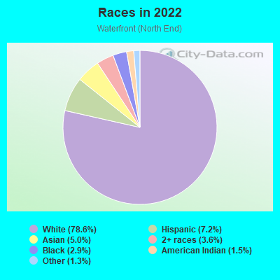
- 8,25978.6%White
- 7557.2%Hispanic or Latino
- 5235.0%Asian
- 3823.6%Two or more races
- 3022.9%Black
- 1541.5%American Indian
- 1341.3%Some other race
Median household income in 2022:
| Waterfront (North End): | $116,842 |
| Boston: | $86,331 |
Distribution of median household income
![Distribution of median household income]()
- 314Less than $10,000
- 484$10,000 to $19,999
- 356$20,000 to $29,999
- 227$30,000 to $39,999
- 528$40,000 to $49,999
- 453$50,000 to $59,999
- 632$60,000 to $74,999
- 814$75,000 to $99,999
- 905$100,000 to $124,999
- 756$125,000 to $149,999
- 510$150,000 to $199,999
- 1,021$200,000 or more

Distribution of owner-occupied house/condo value
![Distribution of owner-occupied house/condo value]()
- 264Less than $50,000
- 231$50,000 to $99,999
- 443$150,000 to $199,999
- 174$200,000 to $249,999
- 78$300,000 to $399,999
- 185$400,000 to $499,999
- 443$500,000 to $749,999
- 318$750,000 to $999,999
- 644$1,000,000 or more

Distribution of rent paid by renters
![Distribution of rent paid by renters]()
- 509$200 to $299
- 430$300 to $399
- 308$400 to $499
- 115$700 to $799
- 357$800 to $899
- 71$900 to $999
- 338$1,000 to $1,249
- 357$1,250 to $1,499
- 1,824$1,500 to $1,999
- 2,917$2,000 or more

Median rent in 2022:
| Waterfront (North End): | $2,378 |
| Boston: | $1,814 |
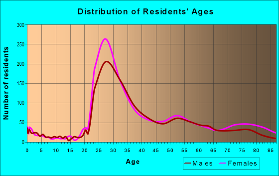
| Males: | 4,593 |
| Females: | 5,051 |
Males:
| This neighborhood: | 32.3 years |
| Whole city: | 32.7 years |
| This neighborhood: | 31.7 years |
| Whole city: | 34.1 years |
Average household size:
| Waterfront (North End): | 1.7 people |
| Boston: | 2.1 people |
Percentage of family households:
| Waterfront (North End): | 14.2% |
| Boston: | 34.5% |
| Here: | 16.5% |
| Boston: | 26.9% |
Percentage of married-couple families with children (among all households):
| Waterfront (North End): | 63.0% |
| Boston: | 24.9% |
Percentage of single-mother households (among all households):
| Waterfront (North End): | 9.9% |
| Boston: | 15.7% |
Percentage of never married males 15 years old and over:
Percentage of never married females 15 years old and over:
| Waterfront (North End): | 33.8% |
| Boston: | 26.8% |
Percentage of never married females 15 years old and over:
| Waterfront (North End): | 36.4% |
| city: | 28.3% |
Percentage of people that speak English not well or not at all:
| Waterfront (North End): | 0.9% |
| Boston: | 8.0% |
Percentage of people born in this state:
Percentage of people born in another U.S. state:
Percentage of native residents but born outside the U.S.:
Percentage of foreign born residents:
| Here: | 47.6% |
| Boston: | 42.4% |
Percentage of people born in another U.S. state:
| Waterfront (North End): | 40.1% |
| Boston: | 26.6% |
Percentage of native residents but born outside the U.S.:
| Here: | 1.2% |
| city: | 3.3% |
Percentage of foreign born residents:
| Here: | 11.0% |
| Boston: | 27.6% |
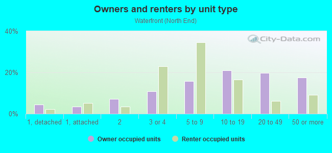
Owner-occupied
Renter-occupied

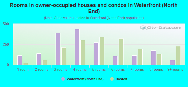
- Rooms in owner-occupied houses and condos in Waterfront <
> - 1151 room
- 1392 rooms
- 3903 rooms
- 4374 rooms
- 2735 rooms
- 1066 rooms
- 1157 rooms
- 1758 rooms
- 589+ rooms
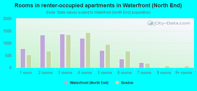
- Rooms in renter-occupied apartments in Waterfront <
> - 7781 room
- 1,3352 rooms
- 1,3673 rooms
- 1,2024 rooms
- 7035 rooms
- 3616 rooms
- 2087 rooms
- 108 rooms
- 09+ rooms
Owner-occupied
Renter-occupied
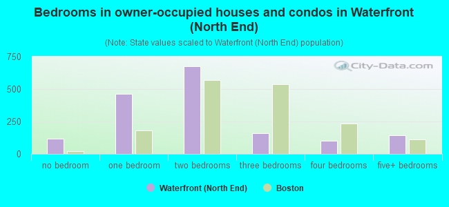
- Bedrooms in owner-occupied houses and condos in Waterfront <
> - 115no bedroom
- 4641 bedroom
- 6782 bedrooms
- 1573 bedrooms
- 1024 bedrooms
- 1425+ bedrooms
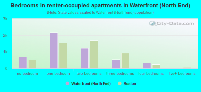
- Bedrooms in renter-occupied apartments in Waterfront <
> - 687no bedroom
- 2,1721 bedroom
- 1,2202 bedrooms
- 5443 bedrooms
- 3384 bedrooms
- 05+ bedrooms
Average number of cars or other vehicles available in houses/condos:
Average number of cars or other vehicles available in apartments:
| This neighborhood: | 1.1 |
| Boston: | 1.4 |
Average number of cars or other vehicles available in apartments:
| Here: | 0.3 |
| city: | 0.7 |
Percentage of units with a mortgage:
| Waterfront (North End): | 65.2% |
| Boston: | 69.7% |
Average estimated '22 value of housing units in 5-or-more-unit structures (14.4% of all units):
| Waterfront (North End): | $382,290 |
| Massachusetts: | $555,768 |
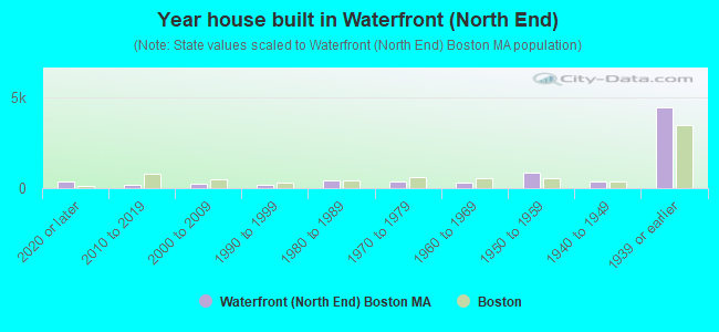
- Year house built in Waterfront <
> - 3492020 or later
- 1912010 to 2019
- 2552000 to 2009
- 1621990 to 1999
- 4301980 to 1989
- 3661970 to 1979
- 3291960 to 1969
- 8371950 to 1959
- 3671940 to 1949
- 4,4371939 or earlier
City-data.com crime index for city in 2020 (higher means more crime):
| City: | 258.2 |
| U.S. average: | 219.5 |
Travel time to work (commute)
![Travel time to work (commute)]()
- 391Less than 5 minutes
- 3565 to 9 minutes
- 1,61710 to 14 minutes
- 1,31315 to 19 minutes
- 98420 to 24 minutes
- 87225 to 29 minutes
- 1,22930 to 34 minutes
- 21635 to 39 minutes
- 52440 to 44 minutes
- 49445 to 59 minutes
- 34360 to 89 minutes
- 7290 or more minutes

Means of transportation to work
![Means of transportation to work]()
- 16.0%1,200Drove a car alone
- 1.0%78Carpooled
- 1.2%89Bus
- 19.0%1,426Subway or elevated rail
- 3.4%258Long-distance train or commuter rail
- 2.1%154Light rail, streetcar or trolley
- 22.6%1,694Ferryboat
- 3.5%261Taxi
- 3.2%238Bicycle
- 34.9%2,619Walked
- 1.2%87Other means
- 23.5%1,766Worked at home

Time leaving home to go to work
![Time leaving home to go to work]()
- 8512:00 a.m. to 4:59 a.m.
- 1645:00 a.m. to 5:29 a.m.
- 2995:30 a.m. to 5:59 a.m.
- 4546:00 a.m. to 6:29 a.m.
- 4526:30 a.m. to 6:59 a.m.
- 9057:00 a.m. to 7:29 a.m.
- 8727:30 a.m. to 7:59 a.m.
- 1,8478:00 a.m. to 8:29 a.m.
- 1,5078:30 a.m. to 8:59 a.m.
- 1,1589:00 a.m. to 9:59 a.m.
- 24910:00 a.m. to 10:59 a.m.
- 9711:00 a.m. to 11:59 a.m.
- 33712:00 p.m. to 3:59 p.m.
- 1314:00 p.m. to 11:59 p.m.

Occupations of males:
- Percentage of males in management occupations (except farmers):
Here: 13.9% city: 12.7%
- Percentage of males in business and financial operations occupations:
Here: 22.9% city: 9.1%
- Percentage of males in computer and mathematical occupations:
Here: 5.6% city: 7.4%
- Percentage of males in architecture and engineering occupations:
Here: 2.8% city: 3.1%
- Percentage of males in life, physical, and social science occupations:
Here: 3.5% city: 3.9%
- Percentage of males in community and social services occupations:
Here: 3.2% city: 1.4%
- Percentage of males in legal occupations:
Here: 7.5% city: 2.5%
- Percentage of males in education, training, and library occupations:
Here: 3.5% city: 5.7%
- Percentage of males in arts, design, entertainment, sports, and media occupations:
Here: 1.3% city: 2.7%
- Percentage of males in healthcare practitioners and technical occupations:
Here: 2.4% city: 4.4%
- Percentage of males in service occupations:
Here: 13.0% city: 16.0%
- Percentage of males in sales and office occupations:
Here: 17.7% city: 15.2%
Occupations of females:
- Percentage of females in management occupations (except farmers):
Here: 14.1% city: 12.2%
- Percentage of females in business and financial operations occupations:
Here: 18.0% city: 9.5%
- Percentage of females in computer and mathematical occupations:
Here: 10.1% city: 3.2%
- Percentage of females in architecture and engineering occupations:
Here: 3.6% city: 1.0%
- Percentage of females in life, physical, and social science occupations:
Here: 6.5% city: 3.3%
- Percentage of females in legal occupations:
Here: 2.1% city: 2.3%
- Percentage of females in education, training, and library occupations:
Here: 5.1% city: 9.4%
- Percentage of females in arts, design, entertainment, sports, and media occupations:
Here: 5.1% city: 3.4%
- Percentage of females in healthcare practitioners and technical occupations:
Here: 5.3% city: 10.2%
- Percentage of females in service occupations:
Here: 3.9% city: 18.6%
- Percentage of females in sales and office occupations:
Here: 21.0% city: 20.2%
- Percentage of females in transportation occupations:
Here: 1.4% city: 0.8%
- Percentage of females in material moving occupations:
Here: 2.2% city: 1.0%
Percentage of people 16-64 in Armed Forces:
| Waterfront (North End): | 0.3% |
| Boston: | 0.1% |
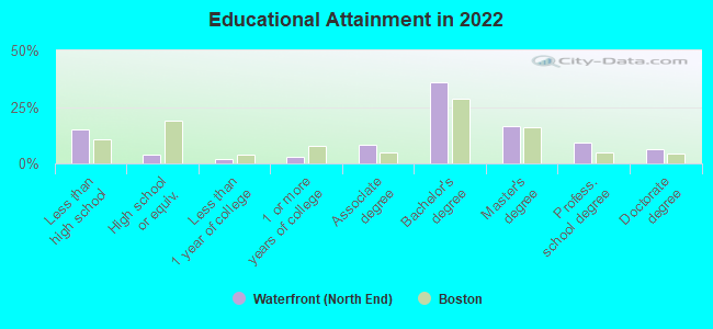
Education in this neighborhood (subdivision or community):
- Percentage of people 3 years and older in K-12 schools:
Waterfront (North End): 20.8% Boston: 11.0%
- Percentage of people 3 years and older in undergraduate colleges:
Waterfront (North End): 5.6% Boston: 11.0%
- Percentage of people 3 years and older in grad. or professional schools:
Waterfront (North End): 7.9% Boston: 4.3%
- Percentage of students K-12 enrolled in private schools:
Waterfront (North End): 0.0% Boston: 13.8%
Percentage of population below poverty level:
| Waterfront (North End): | 12.7% |
| Boston: | 17.1% |
Median year owner moved in (as recorded in 2022):
Median year renter moved in (as recorded in 2022):
| Waterfront (North End): | 2013 |
| Boston: | 2011 |
Median year renter moved in (as recorded in 2022):
| Waterfront (North End): | 2019 |
| Boston: | 2020 |
Percentage of married-couple families with both working:
| Waterfront (North End): | 195.3% |
| Boston: | 78.2% |
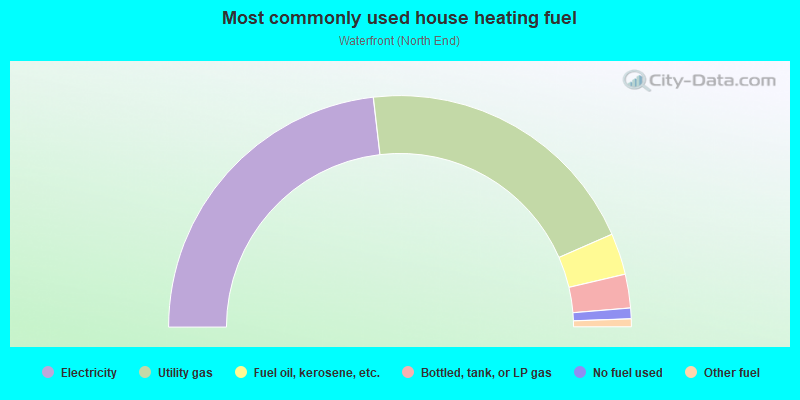
- 46.3%Electricity
- 40.5%Utility gas
- 5.8%Fuel oil, kerosene, etc.
- 4.7%Bottled, tank, or LP gas
- 1.5%No fuel used
- 1.1%Other fuel
Limited-access highways (interstate or state) in this neighborhood:
US Hwy 1 (I- 93, John F Fitzgerald Expy, State Hwy 3)
Length: 1.10 miles
Directions: N-S, SE-NW
Directions: N-S, SE-NW
Highways in this neighborhood:
State Hwy 1 Alt (William F McClellan Hwy)
Length: 0.68 miles
Direction: SW-NE
Direction: SW-NE
Roads and streets:
Commercial St
Length: 0.96 miles
Directions: E-W, N-S, SE-NW, SW-NE
Address range: 26 to 699
Directions: E-W, N-S, SE-NW, SW-NE
Address range: 26 to 699
Atlantic Ave
Length: 0.81 miles
Directions: N-S, SE-NW, SW-NE
Address range: 1 to 404
Directions: N-S, SE-NW, SW-NE
Address range: 1 to 404
North St
Length: 0.47 miles
Directions: E-W, N-S, SW-NE
Address range: 100 to 399
Directions: E-W, N-S, SW-NE
Address range: 100 to 399
Hanover St
Length: 0.40 miles
Directions: E-W, N-S, SW-NE
Address range: 185 to 499
Directions: E-W, N-S, SW-NE
Address range: 185 to 499
Prince St
Length: 0.39 miles
Direction: SE-NW
Address range: 1 to 183
Direction: SE-NW
Address range: 1 to 183
Cross St
Length: 0.34 miles
Directions: E-W, N-S, SE-NW, SW-NE
Address range: 28 to 80
Directions: E-W, N-S, SE-NW, SW-NE
Address range: 28 to 80
Charter St
Length: 0.34 miles
Directions: E-W, SE-NW, SW-NE
Address range: 1 to 199
Directions: E-W, SE-NW, SW-NE
Address range: 1 to 199
Salem St
Length: 0.32 miles
Directions: N-S, SW-NE
Address range: 48 to 299
Directions: N-S, SW-NE
Address range: 48 to 299
Endicott St
Length: 0.27 miles
Directions: N-S, SE-NW
Address range: 50 to 299
Directions: N-S, SE-NW
Address range: 50 to 299
Richmond St
Length: 0.23 miles
Direction: SE-NW
Address range: 38 to 199
Direction: SE-NW
Address range: 38 to 199
Commercial Wharf
Length: 0.23 miles
Directions: E-W, SE-NW, SW-NE
Address range: 1 to 99
Directions: E-W, SE-NW, SW-NE
Address range: 1 to 99
Hull St
Length: 0.21 miles
Directions: E-W, SE-NW, SW-NE
Address range: 1 to 99
Directions: E-W, SE-NW, SW-NE
Address range: 1 to 99
Surface Artery
Length: 0.20 miles
Directions: E-W, SE-NW
Directions: E-W, SE-NW
Long Wharf
Length: 0.20 miles
Direction: E-W
Address range: 1 to 199
Direction: E-W
Address range: 1 to 199
N Margin St
Length: 0.20 miles
Directions: E-W, N-S, SE-NW
Address range: 1 to 113
Directions: E-W, N-S, SE-NW
Address range: 1 to 113
Cooper St
Length: 0.19 miles
Direction: E-W
Address range: 1 to 89
Direction: E-W
Address range: 1 to 89
Battery St
Length: 0.18 miles
Direction: E-W
Address range: 1 to 99
Direction: E-W
Address range: 1 to 99
Fulton St
Length: 0.18 miles
Direction: SW-NE
Address range: 34 to 199
Direction: SW-NE
Address range: 34 to 199
Fleet St
Length: 0.17 miles
Direction: E-W
Address range: 1 to 99
Direction: E-W
Address range: 1 to 99
N Commercial Wharf
Length: 0.15 miles
Directions: E-W, SE-NW
Address range: 22 to 99
Directions: E-W, SE-NW
Address range: 22 to 99
Tileston St
Length: 0.14 miles
Direction: SE-NW
Address range: 1 to 99
Direction: SE-NW
Address range: 1 to 99
Snow Hill St
Length: 0.14 miles
Direction: N-S
Address range: 1 to 99
Direction: N-S
Address range: 1 to 99
N Bennet St
Length: 0.14 miles
Directions: E-W, SE-NW
Address range: 2 to 99
Directions: E-W, SE-NW
Address range: 2 to 99
Clark St
Length: 0.14 miles
Direction: E-W
Address range: 1 to 99
Direction: E-W
Address range: 1 to 99
Stillman St
Length: 0.13 miles
Directions: E-W, SE-NW
Address range: 1 to 99
Directions: E-W, SE-NW
Address range: 1 to 99
E India Row
Length: 0.13 miles
Directions: E-W, N-S
Address range: 67 to 99
Directions: E-W, N-S
Address range: 67 to 99
Union Wharf
Length: 0.13 miles
Direction: E-W
Address range: 1 to 698
Direction: E-W
Address range: 1 to 698
Battery Wharf
Length: 0.12 miles
Direction: E-W
Direction: E-W
Sheafe St
Length: 0.11 miles
Direction: E-W
Address range: 1 to 99
Direction: E-W
Address range: 1 to 99
Thacher St
Length: 0.11 miles
Directions: E-W, SW-NE
Address range: 1 to 32
Directions: E-W, SW-NE
Address range: 1 to 32
Moon St
Length: 0.11 miles
Direction: SW-NE
Address range: 1 to 99
Direction: SW-NE
Address range: 1 to 99
Salutation St
Length: 0.11 miles
Direction: E-W
Address range: 1 to 98
Direction: E-W
Address range: 1 to 98
Eastern Ave
Length: 0.10 miles
Direction: E-W
Address range: 1 to 99
Direction: E-W
Address range: 1 to 99
Lewis St
Length: 0.10 miles
Directions: N-S, SE-NW
Address range: 1 to 99
Directions: N-S, SE-NW
Address range: 1 to 99
Lombard Pl
Length: 0.10 miles
Directions: E-W, SE-NW, SW-NE
Address range: 1 to 99
Directions: E-W, SE-NW, SW-NE
Address range: 1 to 99
Hanover Ave
Length: 0.09 miles
Direction: E-W
Address range: 1 to 98
Direction: E-W
Address range: 1 to 98
Morton St
Length: 0.09 miles
Directions: E-W, N-S, SE-NW
Directions: E-W, N-S, SE-NW
State St
Length: 0.09 miles
Directions: E-W, SW-NE
Address range: 200 to 298
Directions: E-W, SW-NE
Address range: 200 to 298
Harris St
Length: 0.09 miles
Direction: E-W
Address range: 1 to 99
Direction: E-W
Address range: 1 to 99
Central Wharf
Length: 0.08 miles
Direction: E-W
Address range: 1 to 99
Direction: E-W
Address range: 1 to 99
Unity St
Length: 0.08 miles
Direction: SW-NE
Address range: 1 to 99
Direction: SW-NE
Address range: 1 to 99
Bartlett Pl
Length: 0.08 miles
Directions: E-W, N-S
Address range: 1 to 22
Directions: E-W, N-S
Address range: 1 to 22
N415
Length: 0.08 miles
Direction: SE-NW
Direction: SE-NW
North Sq
Length: 0.08 miles
Directions: N-S, SE-NW, SW-NE
Address range: 4 to 99
Directions: N-S, SE-NW, SW-NE
Address range: 4 to 99
Jerusalem Pl
Length: 0.08 miles
Directions: E-W, SW-NE
Directions: E-W, SW-NE
Rowes Wharf
Length: 0.07 miles
Direction: E-W
Address range: 1 to 99
Direction: E-W
Address range: 1 to 99
Parmenter St
Length: 0.07 miles
Directions: E-W, SE-NW
Address range: 1 to 99
Directions: E-W, SE-NW
Address range: 1 to 99
India Wharf
Length: 0.07 miles
Direction: E-W
Address range: 51 to 99
Direction: E-W
Address range: 51 to 99
Wiget St
Length: 0.07 miles
Direction: E-W
Address range: 1 to 99
Direction: E-W
Address range: 1 to 99
Milk St
Length: 0.07 miles
Direction: E-W
Address range: 210 to 299
Direction: E-W
Address range: 210 to 299
Cleveland Pl
Length: 0.06 miles
Direction: E-W
Address range: 1 to 99
Direction: E-W
Address range: 1 to 99
Greenough Ln
Length: 0.06 miles
Direction: SW-NE
Address range: 1 to 99
Direction: SW-NE
Address range: 1 to 99
N Hudson St
Length: 0.06 miles
Directions: N-S, SW-NE
Address range: 1 to 99
Directions: N-S, SW-NE
Address range: 1 to 99
Stillman Pl
Length: 0.06 miles
Direction: N-S
Address range: 3 to 99
Direction: N-S
Address range: 3 to 99
Hanover St Exd
Length: 0.06 miles
Directions: N-S, SW-NE
Address range: 476 to 498
Directions: N-S, SW-NE
Address range: 476 to 498
Lynn St
Length: 0.06 miles
Direction: N-S
Address range: 1 to 99
Direction: N-S
Address range: 1 to 99
Margaret St
Length: 0.06 miles
Direction: SW-NE
Address range: 1 to 99
Direction: SW-NE
Address range: 1 to 99
Commercial Wharf N (N Commercial Wharf)
Length: 0.06 miles
Direction: SE-NW
Address range: 1 to 21
Direction: SE-NW
Address range: 1 to 21
Powers Ct
Length: 0.06 miles
Directions: E-W, N-S
Address range: 1 to 99
Directions: E-W, N-S
Address range: 1 to 99
Noyes Pl
Length: 0.05 miles
Direction: E-W
Address range: 1 to 99
Direction: E-W
Address range: 1 to 99
Henchman St
Length: 0.05 miles
Direction: SW-NE
Address range: 1 to 99
Direction: SW-NE
Address range: 1 to 99
Garden Ct St (Garden Ct)
Length: 0.05 miles
Direction: SW-NE
Address range: 1 to 99
Direction: SW-NE
Address range: 1 to 99
Richmond Pl
Length: 0.05 miles
Direction: SW-NE
Address range: 1 to 99
Direction: SW-NE
Address range: 1 to 99
Foster St
Length: 0.05 miles
Direction: SW-NE
Address range: 1 to 99
Direction: SW-NE
Address range: 1 to 99
Charlestown Brg (N Washington St)
Length: 0.05 miles
Directions: N-S, SE-NW
Directions: N-S, SE-NW
Sumner Tunl
Length: 0.05 miles
Directions: E-W, SW-NE
Directions: E-W, SW-NE
Baldwin Pl
Length: 0.04 miles
Direction: E-W
Address range: 1 to 99
Direction: E-W
Address range: 1 to 99
N Bennett Ct
Length: 0.04 miles
Directions: SE-NW, SW-NE
Address range: 2 to 10
Directions: SE-NW, SW-NE
Address range: 2 to 10
Bakers Aly
Length: 0.04 miles
Directions: E-W, SE-NW
Address range: 1 to 99
Directions: E-W, SE-NW
Address range: 1 to 99
Phipps Pl
Length: 0.04 miles
Directions: E-W, SW-NE
Directions: E-W, SW-NE
Causeway St
Length: 0.04 miles
Direction: SW-NE
Address range: 281 to 299
Direction: SW-NE
Address range: 281 to 299
Foster Wharf
Length: 0.04 miles
Direction: E-W
Direction: E-W
N Hanover Ct
Length: 0.04 miles
Direction: SE-NW
Address range: 1 to 99
Direction: SE-NW
Address range: 1 to 99
Jackson Ave
Length: 0.04 miles
Direction: SW-NE
Address range: 1 to 99
Direction: SW-NE
Address range: 1 to 99
Callahan Tunl
Length: 0.04 miles
Directions: N-S, SW-NE
Directions: N-S, SW-NE
Central St
Length: 0.04 miles
Direction: E-W
Address range: 151 to 199
Direction: E-W
Address range: 151 to 199
Hanover Pl
Length: 0.04 miles
Direction: SE-NW
Direction: SE-NW
Lafayette Ave
Length: 0.04 miles
Direction: SW-NE
Address range: 1 to 99
Direction: SW-NE
Address range: 1 to 99
Lewis Wharf
Length: 0.04 miles
Direction: E-W
Address range: 1 to 699
Direction: E-W
Address range: 1 to 699
Murphy Ct
Length: 0.04 miles
Direction: E-W
Address range: 1 to 99
Direction: E-W
Address range: 1 to 99
Sun Court St
Length: 0.04 miles
Direction: SE-NW
Address range: 1 to 99
Direction: SE-NW
Address range: 1 to 99
Anthony Pl
Length: 0.03 miles
Directions: E-W, SW-NE
Address range: 1 to 99
Directions: E-W, SW-NE
Address range: 1 to 99
Langdon Pl
Length: 0.03 miles
Direction: N-S
Direction: N-S
Salem Ct
Length: 0.03 miles
Direction: E-W
Address range: 1 to 99
Direction: E-W
Address range: 1 to 99
Lathrop Pl
Length: 0.03 miles
Directions: E-W, SE-NW
Address range: 1 to 99
Directions: E-W, SE-NW
Address range: 1 to 99
Wesley Pl
Length: 0.03 miles
Direction: SE-NW
Address range: 1 to 99
Direction: SE-NW
Address range: 1 to 99
Snelling Pl
Length: 0.03 miles
Direction: SW-NE
Address range: 1 to 99
Direction: SW-NE
Address range: 1 to 99
Copps Hill Ter
Length: 0.03 miles
Direction: N-S
Address range: 1 to 99
Direction: N-S
Address range: 1 to 99
Walsh Pl
Length: 0.03 miles
Direction: SW-NE
Address range: 1 to 99
Direction: SW-NE
Address range: 1 to 99
Unity Ct
Length: 0.03 miles
Direction: SE-NW
Address range: 1 to 99
Direction: SE-NW
Address range: 1 to 99
Thacher Ct
Length: 0.03 miles
Direction: N-S
Direction: N-S
Endicott Ct
Length: 0.03 miles
Direction: E-W
Address range: 1 to 99
Direction: E-W
Address range: 1 to 99
Wharf St
Length: 0.03 miles
Direction: E-W
Direction: E-W
Michelangelo St
Length: 0.03 miles
Direction: SW-NE
Address range: 1 to 99
Direction: SW-NE
Address range: 1 to 99
Arch Way
Length: 0.03 miles
Direction: SW-NE
Direction: SW-NE
Wiggin St
Length: 0.03 miles
Direction: SW-NE
Address range: 1 to 99
Direction: SW-NE
Address range: 1 to 99
Lincoln Wharf
Length: 0.02 miles
Direction: E-W
Address range: 1 to 99
Direction: E-W
Address range: 1 to 99
Fulton Pl
Length: 0.02 miles
Direction: SE-NW
Address range: 1 to 99
Direction: SE-NW
Address range: 1 to 99
Quincy Ct
Length: 0.02 miles
Direction: SE-NW
Address range: 1 to 99
Direction: SE-NW
Address range: 1 to 99
India St
Length: 0.02 miles
Direction: E-W
Direction: E-W
Pond Street Pl
Length: 0.02 miles
Direction: E-W
Address range: 1 to 6
Direction: E-W
Address range: 1 to 6
Board Aly
Length: 0.02 miles
Direction: SE-NW
Address range: 1 to 99
Direction: SE-NW
Address range: 1 to 99
Whitlers Aly
Length: 0.02 miles
Direction: E-W
Direction: E-W
Douglas Ct
Length: 0.02 miles
Direction: E-W
Address range: 1 to 99
Direction: E-W
Address range: 1 to 99
Revere Pl
Length: 0.02 miles
Direction: SW-NE
Address range: 1 to 99
Direction: SW-NE
Address range: 1 to 99
Holden Ct
Length: 0.02 miles
Direction: SW-NE
Address range: 1 to 99
Direction: SW-NE
Address range: 1 to 99
N382
Length: 0.00 miles
Direction: SW-NE
Direction: SW-NE