Bridge Statistics for City of The Dalles, Oregon (OR)
Condition, Traffic, Stress, Structural Evaluation, Project Costs
- National Bridge Inventory (NBI) Statistics
- 28Number of bridges
- 443ft / 135mTotal length
- $6,507,000Total costs
- 439,447Total average daily traffic
- 86,933Total average daily truck traffic
- National Bridge Inventory (NBI) Registered Bridges for City of The Dalles
- No street view available for this location
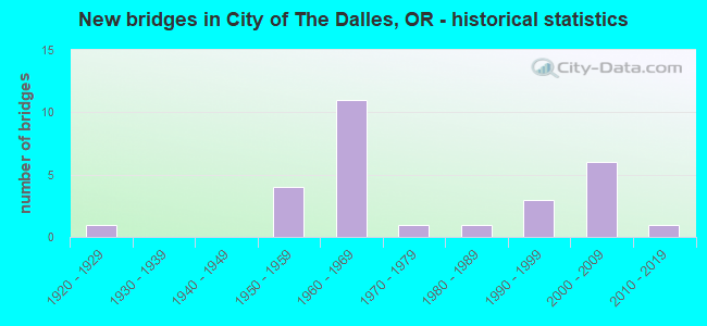
- New bridges - historical statistics
- 11920-1929
- 41950-1959
- 111960-1969
- 11970-1979
- 11980-1989
- 31990-1999
- 62000-2009
- 12010-2019


- Bridge Condition - Deck
- 61.1%Good
- 38.9%Satisfactory

- Bridge Condition - Superstructure
- 16.7%Very good
- 44.4%Good
- 27.8%Satisfactory
- 11.1%Fair

- Bridge Condition - Substructure
- 33.3%Very good
- 33.3%Good
- 27.8%Satisfactory
- 5.6%Fair

- Bridge Condition - Channel
- 16.7%Very good
- 50.0%Good
- 33.3%Satisfactory
Find on map >> Show street view
Structure Number: 463 365 00103, Location: CITY OF THE DALLES (Lat: 45.603711, Lng: -121.200619), Route carried "on" structure: City street , Year Built: 1987, Status: Open, Structure Length: 3.02m (9.91ft), Average Daily Traffic: 2,138 (year 2020), Truck Traffic: 10%, Average Future Daily Traffic: 2,448 (year 2025), Design Load: HS 25 or greater, Features Intersected: MILL CREEK, Facility Carried by Structure: W 9TH STREET
Minimum Vertical Clearance: 30+ m (98+ ft), Kilometerpoint: 1.658, Lanes on structure: 2, Owner: City or Municipal Highway Agency, Approaching Roadway Width: 13.4m (44.0ft), Material/Design: Prestressed concrete, Design/Construction: Stringer/Multi-beam, Number Of Spans In Main Unit: 1, Length of Maximum Span: 29.9m (98.1ft), Curb or Sidewalk Widths: Left: 1.5m (4.9ft), Right: 1.5m (4.9ft), Curb-To-Curb Width: 13.4m (44.0ft), Out-to-Out Width: 17.5m (57.4ft)
Condition: Deck: Good, Superstructure: Good, Substructure: Very good, Channel: Satisfactory, Operating Rating: 64.4 metric tons, Method Used To Determine Operating Rating: Allowable Stress (AS), Inventory Rating: 39.0 metric tons, Method Used To Determine Inventory Rating: Allowable Stress (AS), Structural Evaluation: Better than present minimum criteria, Deck Geometry: Better than present minimum criteria, Waterway Adequacy: Equal to present desirable criteria, Approach Roadway Alignment: Equal to present desirable criteria, Designated Inspection Frequency: Every 24 months, Inspection Date: August 2020, Deck Structure Type: Concrete Cast-file-Place, Wearing Surface/Protective System: Wearing Surface: Epoxy Overlay, Deck Protection: Epoxy Coated Reinforcing
Find on map >> Show street view
Structure Number: 464 000000059, Location: CITY OF THE DALLES (Lat: 45.603131, Lng: -121.193550), Route carried "on" structure: City street , Year Built: 1920, Year Reconstructed: 2001, Status: Posted for load, Structure Length: 3.87m (12.70ft), Average Daily Traffic: 15,627 (year 2020), Truck Traffic: 10%, Average Future Daily Traffic: 22,842 (year 2025), Design Load: H 15, Features Intersected: MILL CREEK, Facility Carried by Structure: W 6TH STREET
Minimum Vertical Clearance: 30+ m (98+ ft), Kilometerpoint: 0.950, Lanes on structure: 2, Owner: City or Municipal Highway Agency, Approaching Roadway Width: 7.3m (24.0ft), Material/Design: Concrete continuous, Design/Construction: Tee Beam, Number Of Spans In Main Unit: 4, Length of Maximum Span: 12.2m (40.0ft), Curb or Sidewalk Widths: Left: 1.2m (3.9ft), Right: 1.2m (3.9ft), Curb-To-Curb Width: 6.2m (20.3ft), Out-to-Out Width: 9.5m (31.2ft)
Condition: Deck: Satisfactory, Superstructure: Good, Substructure: Fair, Channel: Satisfactory, Operating Rating: 10.4 metric tons, Method Used To Determine Operating Rating: Load and Resistance Factor Rating (LRFR) rating reported by rating factor(RF) method using HL-93 loadings, Inventory Rating: 8.1 metric tons, Method Used To Determine Inventory Rating: Load and Resistance Factor Rating (LRFR) rating reported by rating factor(RF) method using HL-93 loadings, Structural Evaluation: High priority of corrective action, Deck Geometry: High priority of replacement, Waterway Adequacy: Equal to present desirable criteria, Approach Roadway Alignment: Equal to present desirable criteria, Bridge Posting: Required (Relationship of Operating Rating to Maximum Legal Load: > 39.9% below), Length Of Structure Improvement: 3.90m (12.80ft), Designated Inspection Frequency: Every 12 months, Inspection Date: August 2021, Bridge Improvement Cost: $407,000, Roadway Improvement Cost: $41,000, Total Project Cost: $651,000, Deck Structure Type: Concrete Cast-file-Place, Wearing Surface/Protective System: Wearing Surface: Bituminous
Find on map >> Show street view
Structure Number: 6635 004 00077, Location: 008 MI S ORE WASH BOARDER (Lat: 45.601150, Lng: -121.138919), Route carried "on" structure: US 197, Year Built: 1954, Status: Open, Structure Length: 16.86m (55.31ft), Average Daily Traffic: 5,699 (year 2020), Truck Traffic: 17%, Average Future Daily Traffic: 8,600 (year 2040), Design Load: HS 20, Features Intersected: UPRR & FRONTAGE RD
Minimum Vertical Clearance: 30+ m (98+ ft), Kilometerpoint: 1.223, Lanes on structure: 2, Lanes under structure: 2, Base Highway Network: Yes, Owner: State Highway Agency, Approaching Roadway Width: 9.1m (29.9ft), Material/Design: Steel continuous, Design/Construction: Girder and Floorbeam System, Number Of Spans In Main Unit: 1, Number Of Approach Spans: 7, Length of Maximum Span: 30.5m (100.1ft), Curb or Sidewalk Widths: Left: 1.2m (3.9ft), Right: 0.0m, Curb-To-Curb Width: 7.3m (24.0ft), Out-to-Out Width: 9.7m (31.8ft)
Condition: Deck: Satisfactory, Superstructure: Satisfactory, Substructure: Good, Operating Rating: 48.0 metric tons, Method Used To Determine Operating Rating: Load and Resistance Factor Rating (LRFR) rating reported by rating factor(RF) method using HL-93 loadings, Inventory Rating: 36.9 metric tons, Method Used To Determine Inventory Rating: Load and Resistance Factor Rating (LRFR) rating reported by rating factor(RF) method using HL-93 loadings, Structural Evaluation: Equal to present minimum criteria, Deck Geometry: High priority of replacement, Underclear: High priority of corrective action, Approach Roadway Alignment: Equal to present minimum criteria, Length Of Structure Improvement: 16.90m (55.45ft), Designated Inspection Frequency: Every 24 months, Critical Feature Inspection Frequency: Every 24 months, Inspection Date: August 2020, Critical Feature Inspection Date: October 2021, Bridge Improvement Cost: $1,771,000, Roadway Improvement Cost: $177,000, Total Project Cost: $2,833,000, Deck Structure Type: Concrete Cast-file-Place, Wearing Surface/Protective System: Wearing Surface: Bituminous
Find on map >> Show street view
Structure Number: 8276 002 08262, Location: IN THE DALLES (Lat: 45.623081, Lng: -121.213000), Route carried "on" structure: Interstate 84, Year Built: 1957, Status: Open, Structure Length: 4.39m (14.40ft), Average Daily Traffic: 21,174 (year 2020), Truck Traffic: 28%, Average Future Daily Traffic: 35,800 (year 2040), Design Load: HS 20, Features Intersected: HOSTELLER WAY
Minimum Vertical Clearance: 30+ m (98+ ft), Kilometerpoint: 132.964, Lanes on structure: 4, Lanes under structure: 2, Base Highway Network: Yes, Owner: State Highway Agency, Approaching Roadway Width: 25.6m (84.0ft), Skew: 2 degrees, Material/Design: Concrete continuous, Design/Construction: Stringer/Multi-beam, Number Of Spans In Main Unit: 3, Length of Maximum Span: 17.1m (56.1ft), Curb-To-Curb Width: 25.7m (84.3ft), Out-to-Out Width: 27.1m (88.9ft)
Condition: Deck: Satisfactory, Superstructure: Satisfactory, Substructure: Satisfactory, Operating Rating: 14.6 metric tons, Method Used To Determine Operating Rating: Load and Resistance Factor Rating (LRFR) rating reported by rating factor(RF) method using HL-93 loadings, Inventory Rating: 11.0 metric tons, Method Used To Determine Inventory Rating: Load and Resistance Factor Rating (LRFR) rating reported by rating factor(RF) method using HL-93 loadings, Structural Evaluation: High priority of corrective action, Deck Geometry: Superior to present desirable criteria, Underclear: High priority of corrective action, Approach Roadway Alignment: Equal to present desirable criteria, Length Of Structure Improvement: 4.40m (14.44ft), Designated Inspection Frequency: Every 24 months, Inspection Date: June 2021, Bridge Improvement Cost: $461,000, Roadway Improvement Cost: $46,000, Total Project Cost: $738,000, Deck Structure Type: Concrete Cast-file-Place, Wearing Surface/Protective System: Wearing Surface: Bituminous, Membrane: Preformed Fabric
Find on map >> Show street view
Structure Number: 8526 004 00064, Location: 006 MI S ORE WASH BORDER (Lat: 45.602811, Lng: -121.138500), Route carried "on" structure: US 197, Year Built: 1964, Status: Open, Structure Length: 6.43m (21.10ft), Average Daily Traffic: 5,699 (year 2020), Truck Traffic: 17%, Average Future Daily Traffic: 8,600 (year 2040), Design Load: HS 20, Features Intersected: HWY 002
Minimum Vertical Clearance: 30+ m (98+ ft), Kilometerpoint: 1.030, Lanes on structure: 2, Lanes under structure: 4, Base Highway Network: Yes, Owner: State Highway Agency, Approaching Roadway Width: 10.4m (34.1ft), Skew: 2 degrees, Material/Design: Concrete continuous, Design/Construction: Box Beam or Girders - Multiple, Number Of Spans In Main Unit: 3, Length of Maximum Span: 28.3m (92.8ft), Curb-To-Curb Width: 9.1m (29.9ft), Out-to-Out Width: 10.6m (34.8ft)
Condition: Deck: Good, Superstructure: Satisfactory, Substructure: Good, Operating Rating: 24.6 metric tons, Method Used To Determine Operating Rating: Load and Resistance Factor Rating (LRFR) rating reported by rating factor(RF) method using HL-93 loadings, Inventory Rating: 19.1 metric tons, Method Used To Determine Inventory Rating: Load and Resistance Factor Rating (LRFR) rating reported by rating factor(RF) method using HL-93 loadings, Structural Evaluation: Meets minimum limits, Deck Geometry: Meets minimum limits, Underclear: High priority of corrective action, Approach Roadway Alignment: Equal to present minimum criteria, Length Of Structure Improvement: 6.40m (21.00ft), Designated Inspection Frequency: Every 24 months, Inspection Date: August 2020, Bridge Improvement Cost: $764,000, Roadway Improvement Cost: $76,000, Total Project Cost: $1,223,000, Deck Structure Type: Concrete Cast-file-Place, Wearing Surface/Protective System: Wearing Surface: Bituminous
Find on map >> Show street view
Structure Number: 8603 002 08428, Location: IN THE DALLES (Lat: 45.606589, Lng: -121.191919), Route carried "on" structure: Interstate 84, Year Built: 1964, Status: Open, Structure Length: 8.63m (28.31ft), Average Daily Traffic: 11,521 (year 2020), Truck Traffic: 28%, Average Future Daily Traffic: 18,200 (year 2040), Design Load: HS 20, Features Intersected: UPRR
Minimum Vertical Clearance: 30+ m (98+ ft), Kilometerpoint: 135.636, Lanes on structure: 2, Base Highway Network: Yes, Owner: State Highway Agency, Approaching Roadway Width: 11.6m (38.1ft), Material/Design: Steel, Design/Construction: Stringer/Multi-beam, Number Of Spans In Main Unit: 1, Number Of Approach Spans: 5, Length of Maximum Span: 34.7m (113.8ft), Curb-To-Curb Width: 9.8m (32.2ft), Out-to-Out Width: 10.5m (34.4ft)
Condition: Deck: Satisfactory, Superstructure: Satisfactory, Substructure: Satisfactory, Operating Rating: 37.3 metric tons, Method Used To Determine Operating Rating: Load and Resistance Factor Rating (LRFR) rating reported by rating factor(RF) method using HL-93 loadings, Inventory Rating: 28.8 metric tons, Method Used To Determine Inventory Rating: Load and Resistance Factor Rating (LRFR) rating reported by rating factor(RF) method using HL-93 loadings, Structural Evaluation: Equal to present minimum criteria, Deck Geometry: Meets minimum limits, Underclear: Somewhat better than minimum adequacy, Approach Roadway Alignment: Equal to present desirable criteria, Designated Inspection Frequency: Every 24 months, Inspection Date: June 2021, Deck Structure Type: Concrete Cast-file-Place, Wearing Surface/Protective System: Wearing Surface: Latex Concrete
Find on map >> Show street view
Structure Number: 8603W002 08428, Location: IN THE DALLES (Lat: 45.606750, Lng: -121.192028), Route carried "on" structure: Interstate 84, Year Built: 1964, Status: Open, Structure Length: 9.42m (30.91ft), Average Daily Traffic: 11,521 (year 2020), Truck Traffic: 28%, Average Future Daily Traffic: 18,200 (year 2040), Design Load: HS 20, Features Intersected: UPRR
Minimum Vertical Clearance: 30+ m (98+ ft), Kilometerpoint: 135.636, Lanes on structure: 2, Base Highway Network: Yes, Owner: State Highway Agency, Approaching Roadway Width: 11.6m (38.1ft), Material/Design: Steel, Design/Construction: Stringer/Multi-beam, Number Of Spans In Main Unit: 1, Number Of Approach Spans: 5, Length of Maximum Span: 38.4m (126.0ft), Curb-To-Curb Width: 9.3m (30.5ft), Out-to-Out Width: 10.0m (32.8ft)
Condition: Deck: Satisfactory, Superstructure: Satisfactory, Substructure: Satisfactory, Operating Rating: 34.0 metric tons, Method Used To Determine Operating Rating: Load and Resistance Factor Rating (LRFR) rating reported by rating factor(RF) method using HL-93 loadings, Inventory Rating: 26.2 metric tons, Method Used To Determine Inventory Rating: Load and Resistance Factor Rating (LRFR) rating reported by rating factor(RF) method using HL-93 loadings, Structural Evaluation: Equal to present minimum criteria, Deck Geometry: Meets minimum limits, Underclear: Equal to present minimum criteria, Approach Roadway Alignment: Equal to present desirable criteria, Designated Inspection Frequency: Every 24 months, Inspection Date: June 2021, Deck Structure Type: Concrete Cast-file-Place, Wearing Surface/Protective System: Wearing Surface: Latex Concrete
Find on map >> Show street view
Structure Number: 8775 002 08415, Location: IN THE DALLES (Lat: 45.606961, Lng: -121.194631), Route carried "on" structure: Interstate 84, Year Built: 1964, Status: Open, Structure Length: 13.84m (45.41ft), Average Daily Traffic: 23,043 (year 2020), Truck Traffic: 28%, Average Future Daily Traffic: 36,400 (year 2040), Design Load: HS 20, Features Intersected: HWY 292 O-XING
Minimum Vertical Clearance: 30+ m (98+ ft), Kilometerpoint: 135.426, Lanes on structure: 4, Lanes under structure: 2, Base Highway Network: Yes, Owner: State Highway Agency, Approaching Roadway Width: 11.6m (38.1ft), Skew: 30 degrees, Material/Design: Steel continuous, Design/Construction: Stringer/Multi-beam, Number Of Spans In Main Unit: 2, Number Of Approach Spans: 5, Length of Maximum Span: 38.7m (127.0ft), Curb-To-Curb Width: 19.0m (62.3ft), Out-to-Out Width: 20.5m (67.3ft)
Condition: Deck: Satisfactory, Superstructure: Fair, Substructure: Satisfactory, Operating Rating: 18.1 metric tons, Method Used To Determine Operating Rating: Load and Resistance Factor Rating (LRFR) rating reported by rating factor(RF) method using HL-93 loadings, Inventory Rating: 13.9 metric tons, Method Used To Determine Inventory Rating: Load and Resistance Factor Rating (LRFR) rating reported by rating factor(RF) method using HL-93 loadings, Structural Evaluation: High priority of corrective action, Deck Geometry: Meets minimum limits, Underclear: Somewhat better than minimum adequacy, Approach Roadway Alignment: Equal to present desirable criteria, Designated Inspection Frequency: Every 24 months, Critical Feature Inspection Frequency: Every 24 months, Inspection Date: March 2021, Critical Feature Inspection Date: March 2021, Deck Structure Type: Concrete Cast-file-Place, Wearing Surface/Protective System: Wearing Surface: Latex Concrete
Find on map >> Show street view
Structure Number: 8776 002 08745, Location: 017 MI E THE DALLES (Lat: 45.605531, Lng: -121.130331), Route carried "on" structure: Interstate 84, Year Built: 1964, Status: Open, Structure Length: 19.51m (64.01ft), Average Daily Traffic: 18,268 (year 2020), Truck Traffic: 37%, Average Future Daily Traffic: 27,200 (year 2040), Design Load: HS 20, Features Intersected: UPRR
Minimum Vertical Clearance: 30+ m (98+ ft), Kilometerpoint: 140.737, Lanes on structure: 4, Base Highway Network: Yes, Owner: State Highway Agency, Approaching Roadway Width: 11.6m (38.1ft), Skew: 30 degrees, Material/Design: Steel continuous, Design/Construction: Stringer/Multi-beam, Number Of Spans In Main Unit: 2, Number Of Approach Spans: 10, Length of Maximum Span: 39.6m (129.9ft), Curb-To-Curb Width: 18.9m (62.0ft), Out-to-Out Width: 20.4m (66.9ft)
Condition: Deck: Satisfactory, Superstructure: Fair, Substructure: Satisfactory, Operating Rating: 15.6 metric tons, Method Used To Determine Operating Rating: Load and Resistance Factor Rating (LRFR) rating reported by rating factor(RF) method using HL-93 loadings, Inventory Rating: 12.0 metric tons, Method Used To Determine Inventory Rating: Load and Resistance Factor Rating (LRFR) rating reported by rating factor(RF) method using HL-93 loadings, Structural Evaluation: High priority of corrective action, Deck Geometry: Meets minimum limits, Underclear: Somewhat better than minimum adequacy, Approach Roadway Alignment: Equal to present desirable criteria, Designated Inspection Frequency: Every 24 months, Critical Feature Inspection Frequency: Every 24 months, Inspection Date: November 2021, Critical Feature Inspection Date: November 2021, Deck Structure Type: Concrete Cast-file-Place, Wearing Surface/Protective System: Wearing Surface: Latex Concrete
Find on map >> Show street view
Structure Number: 8804 002C08562, Location: IN THE DALLES (Lat: 45.597769, Lng: -121.169411), Route carried "on" structure: ServiceState highway 84, Year Built: 1964, Status: Open, Structure Length: 18.62m (61.09ft), Average Daily Traffic: 5,968 (year 2020), Truck Traffic: 6%, Average Future Daily Traffic: 6,200 (year 2030), Design Load: HS 20, Features Intersected: UPRR & HWY 292 FR, Facility Carried by Structure: BREWERY GRADE
Minimum Vertical Clearance: 30+ m (98+ ft), Kilometerpoint: 137.824, Lanes on structure: 2, Lanes under structure: 3, Owner: State Highway Agency, Approaching Roadway Width: 9.8m (32.2ft), Material/Design: Steel, Design/Construction: Stringer/Multi-beam, Number Of Spans In Main Unit: 1, Number Of Approach Spans: 9, Length of Maximum Span: 29.6m (97.1ft), Curb-To-Curb Width: 9.1m (29.9ft), Out-to-Out Width: 10.7m (35.1ft)
Condition: Deck: Good, Superstructure: Good, Substructure: Good, Operating Rating: 24.9 metric tons, Method Used To Determine Operating Rating: Load and Resistance Factor Rating (LRFR) rating reported by rating factor(RF) method using HL-93 loadings, Inventory Rating: 19.1 metric tons, Method Used To Determine Inventory Rating: Load and Resistance Factor Rating (LRFR) rating reported by rating factor(RF) method using HL-93 loadings, Structural Evaluation: Meets minimum limits, Deck Geometry: Meets minimum limits, Underclear: Meets minimum limits, Approach Roadway Alignment: Equal to present minimum criteria, Designated Inspection Frequency: Every 24 months, Inspection Date: August 2020, Deck Structure Type: Concrete Cast-file-Place, Wearing Surface/Protective System: Wearing Surface: Epoxy Overlay
Find on map >> Show street view
Structure Number: 8805 002C08551, Location: IN THE DALLES (Lat: 45.599669, Lng: -121.169061), Route carried "on" structure: Ramp Interstate 84, Year Built: 1964, Status: Open, Structure Length: 5.55m (18.21ft), Average Daily Traffic: 5,968 (year 2020), Truck Traffic: 6%, Average Future Daily Traffic: 4,917 (year 2030), Design Load: HS 20, Features Intersected: I-84 (HWY 002), Facility Carried by Structure: BREWERY GRADE
Minimum Vertical Clearance: 30+ m (98+ ft), Kilometerpoint: 137.615, Lanes on structure: 2, Lanes under structure: 4, Owner: State Highway Agency, Approaching Roadway Width: 10.4m (34.1ft), Material/Design: Prestressed concrete, Design/Construction: Stringer/Multi-beam, Number Of Spans In Main Unit: 3, Length of Maximum Span: 25.0m (82.0ft), Curb-To-Curb Width: 9.1m (29.9ft), Out-to-Out Width: 10.7m (35.1ft)
Condition: Deck: Good, Superstructure: Good, Substructure: Good, Operating Rating: 22.0 metric tons, Method Used To Determine Operating Rating: Load and Resistance Factor Rating (LRFR) rating reported by rating factor(RF) method using HL-93 loadings, Inventory Rating: 16.8 metric tons, Method Used To Determine Inventory Rating: Load and Resistance Factor Rating (LRFR) rating reported by rating factor(RF) method using HL-93 loadings, Structural Evaluation: Meets minimum limits, Deck Geometry: Meets minimum limits, Underclear: High priority of corrective action, Approach Roadway Alignment: Equal to present desirable criteria, Length Of Structure Improvement: 5.50m (18.04ft), Designated Inspection Frequency: Every 24 months, Inspection Date: August 2020, Bridge Improvement Cost: $664,000, Roadway Improvement Cost: $66,000, Total Project Cost: $1,062,000, Deck Structure Type: Concrete Cast-file-Place, Wearing Surface/Protective System: Wearing Surface: Bituminous
Find on map >> Show street view
Structure Number: 16010 000 0032, Location: CITY OF THE DALLES (Lat: 45.602689, Lng: -121.200439), Route carried "on" structure: City street , Year Built: 1975, Status: Open, Structure Length: 3.41m (11.19ft), Average Daily Traffic: 8,665 (year 2020), Truck Traffic: 10%, Average Future Daily Traffic: 9,415 (year 2025), Design Load: HS 20, Features Intersected: MILL CREEK, Facility Carried by Structure: W 10TH STREET
Minimum Vertical Clearance: 30+ m (98+ ft), Kilometerpoint: 0.000, Lanes on structure: 2, Owner: City or Municipal Highway Agency, Approaching Roadway Width: 13.4m (44.0ft), Skew: 4 degrees, Material/Design: Prestressed concrete, Design/Construction: Stringer/Multi-beam, Number Of Spans In Main Unit: 1, Length of Maximum Span: 33.5m (109.9ft), Curb or Sidewalk Widths: Left: 1.5m (4.9ft), Right: 1.5m (4.9ft), Curb-To-Curb Width: 13.4m (44.0ft), Out-to-Out Width: 17.2m (56.4ft)
Condition: Deck: Good, Superstructure: Good, Substructure: Good, Channel: Good, Operating Rating: 68.9 metric tons, Method Used To Determine Operating Rating: Allowable Stress (AS), Inventory Rating: 40.8 metric tons, Method Used To Determine Inventory Rating: Allowable Stress (AS), Structural Evaluation: Better than present minimum criteria, Deck Geometry: Equal to present minimum criteria, Waterway Adequacy: Equal to present desirable criteria, Approach Roadway Alignment: Equal to present desirable criteria, Designated Inspection Frequency: Every 24 months, Inspection Date: August 2020, Deck Structure Type: Concrete Cast-file-Place, Wearing Surface/Protective System: Wearing Surface: Epoxy Overlay
Find on map >> Show street view
Structure Number: 18153 002 08213, Location: WEST THE DALLES (Lat: 45.630625, Lng: -121.213486), Route carried "on" structure: Ramp US 84, Year Built: 1997, Status: Open, Structure Length: 5.55m (18.21ft), Average Daily Traffic: 1,980 (year 2020), Truck Traffic: 28%, Average Future Daily Traffic: 1,600 (year 2030), Design Load: HS 25 or greater, Features Intersected: I-84 (HWY 002), Facility Carried by Structure: RIVER RD
Minimum Vertical Clearance: 30+ m (98+ ft), Kilometerpoint: 132.079, Lanes on structure: 3, Lanes under structure: 4, Owner: State Highway Agency, Approaching Roadway Width: 23.2m (76.1ft), Skew: 5 degrees, Material/Design: Prestressed concrete, Design/Construction: Box Beam or Girders - Multiple, Number Of Spans In Main Unit: 1, Length of Maximum Span: 55.5m (182.1ft), Curb or Sidewalk Widths: Left: 2.1m (6.9ft), Right: 2.1m (6.9ft), Curb-To-Curb Width: 23.0m (75.5ft), Out-to-Out Width: 25.5m (83.7ft)
Condition: Deck: Good, Superstructure: Good, Substructure: Good, Operating Rating: 32.7 metric tons, Method Used To Determine Operating Rating: Load and Resistance Factor Rating (LRFR) rating reported by rating factor(RF) method using HL-93 loadings, Inventory Rating: 25.3 metric tons, Method Used To Determine Inventory Rating: Load and Resistance Factor Rating (LRFR) rating reported by rating factor(RF) method using HL-93 loadings, Structural Evaluation: Equal to present minimum criteria, Deck Geometry: Superior to present desirable criteria, Underclear: Superior to present desirable criteria, Approach Roadway Alignment: Equal to present desirable criteria, Designated Inspection Frequency: Every 24 months, Inspection Date: September 2020, Deck Structure Type: Concrete Cast-file-Place, Wearing Surface/Protective System: Wearing Surface: Monolithic Concrete, Deck Protection: Epoxy Coated Reinforcing
Find on map >> Show street view
Structure Number: 18154 002 08208, Location: WEST DALLES @ CHEN INTER (Lat: 45.630750, Lng: -121.212681), Route carried "on" structure: Ramp US 84, Year Built: 1998, Status: Open, Structure Length: 3.22m (10.56ft), Average Daily Traffic: 1,980 (year 2020), Truck Traffic: 28%, Average Future Daily Traffic: 1,600 (year 2030), Design Load: HS 25 or greater, Features Intersected: UPRR, Facility Carried by Structure: RIVER RD
Minimum Vertical Clearance: 30+ m (98+ ft), Kilometerpoint: 132.159, Lanes on structure: 2, Owner: State Highway Agency, Approaching Roadway Width: 21.0m (68.9ft), Skew: 3 degrees, Material/Design: Concrete, Design/Construction: Box Beam or Girders - Multiple, Number Of Spans In Main Unit: 1, Length of Maximum Span: 31.4m (103.0ft), Curb or Sidewalk Widths: Left: 2.1m (6.9ft), Right: 2.1m (6.9ft), Curb-To-Curb Width: 21.0m (68.9ft), Out-to-Out Width: 25.3m (83.0ft)
Condition: Deck: Good, Superstructure: Good, Substructure: Very good, Operating Rating: 47.3 metric tons, Method Used To Determine Operating Rating: Load and Resistance Factor Rating (LRFR) rating reported by rating factor(RF) method using HL-93 loadings, Inventory Rating: 36.3 metric tons, Method Used To Determine Inventory Rating: Load and Resistance Factor Rating (LRFR) rating reported by rating factor(RF) method using HL-93 loadings, Structural Evaluation: Better than present minimum criteria, Deck Geometry: Superior to present desirable criteria, Underclear: Equal to present desirable criteria, Approach Roadway Alignment: Equal to present desirable criteria, Designated Inspection Frequency: Every 24 months, Inspection Date: September 2020, Deck Structure Type: Concrete Cast-file-Place, Wearing Surface/Protective System: Deck Protection: Epoxy Coated Reinforcing
Find on map >> Show street view
Structure Number: 19152 292 0202, Location: 011 MI E THE DALLES (Lat: 45.598950, Lng: -121.140261), Route carried "on" structure: State highway 30, Year Built: 2003, Status: Open, Structure Length: 0.63m (2.07ft), Average Daily Traffic: 5,416 (year 2020), Truck Traffic: 15%, Average Future Daily Traffic: 7,500 (year 2040), Design Load: HL 93, Features Intersected: THREE MILE CREEK, Facility Carried by Structure: HWY 292
Minimum Vertical Clearance: 30+ m (98+ ft), Kilometerpoint: 32.509, Lanes on structure: 3, Owner: State Highway Agency, Approaching Roadway Width: 19.2m (63.0ft), Skew: 4 degrees, Material/Design: Steel, Design/Construction: Culvert, Number Of Spans In Main Unit: 1, Length of Maximum Span: 6.3m (20.7ft)
Condition: Channel: Good, Culverts: Very good, Operating Rating: 89.7 metric tons, Method Used To Determine Operating Rating: Load and Resistance Factor Rating (LRFR) rating reported by rating factor(RF) method using HL-93 loadings, Inventory Rating: 69.0 metric tons, Method Used To Determine Inventory Rating: Load and Resistance Factor Rating (LRFR) rating reported by rating factor(RF) method using HL-93 loadings, Structural Evaluation: Equal to present desirable criteria, Waterway Adequacy: Equal to present minimum criteria, Approach Roadway Alignment: Equal to present desirable criteria, Designated Inspection Frequency: Every 24 months, Inspection Date: August 2020
Find on map >> Show street view
Structure Number: 19156 002 08478, Location: IN THE DALLES (Lat: 45.603889, Lng: -121.182769), Route carried "on" structure: Interstate 84, Year Built: 2003, Status: Open, Structure Length: 2.26m (7.41ft), Average Daily Traffic: 23,043 (year 2020), Truck Traffic: 28%, Average Future Daily Traffic: 36,400 (year 2040), Design Load: HL 93, Features Intersected: UNION STREET
Minimum Vertical Clearance: 30+ m (98+ ft), Kilometerpoint: 136.440, Lanes on structure: 4, Lanes under structure: 2, Base Highway Network: Yes, Owner: State Highway Agency, Approaching Roadway Width: 11.9m (39.0ft), Skew: 30 degrees, Material/Design: Prestressed concrete continuous, Design/Construction: Frame, Number Of Spans In Main Unit: 1, Length of Maximum Span: 21.4m (70.2ft), Curb-To-Curb Width: 23.5m (77.1ft), Out-to-Out Width: 28.0m (91.9ft)
Condition: Deck: Good, Superstructure: Very good, Substructure: Very good, Operating Rating: 27.9 metric tons, Method Used To Determine Operating Rating: Load and Resistance Factor Rating (LRFR) rating reported by rating factor(RF) method using HL-93 loadings, Inventory Rating: 21.7 metric tons, Method Used To Determine Inventory Rating: Load and Resistance Factor Rating (LRFR) rating reported by rating factor(RF) method using HL-93 loadings, Structural Evaluation: Somewhat better than minimum adequacy, Deck Geometry: Superior to present desirable criteria, Underclear: High priority of corrective action, Approach Roadway Alignment: Equal to present desirable criteria, Designated Inspection Frequency: Every 24 months, Inspection Date: June 2021, Deck Structure Type: Concrete Cast-file-Place, Wearing Surface/Protective System: Wearing Surface: Epoxy Overlay, Deck Protection: Epoxy Coated Reinforcing
Find on map >> Show street view
Structure Number: 19745 002 08368, Location: IN THE DALLES (Lat: 45.609661, Lng: -121.203061), Route carried "on" structure: Interstate 84, Year Built: 2005, Status: Open, Structure Length: 5.18m (16.99ft), Average Daily Traffic: 21,821 (year 2020), Truck Traffic: 28%, Average Future Daily Traffic: 35,200 (year 2040), Design Load: HL 93, Features Intersected: US 30 (HWY 292)
Minimum Vertical Clearance: 30+ m (98+ ft), Kilometerpoint: 134.654, Lanes on structure: 5, Lanes under structure: 2, Base Highway Network: Yes, Owner: State Highway Agency, Approaching Roadway Width: 29.7m (97.4ft), Skew: 31 degrees, Material/Design: Prestressed concrete, Design/Construction: Slab, Number Of Spans In Main Unit: 3, Length of Maximum Span: 20.0m (65.6ft), Curb-To-Curb Width: 29.7m (97.4ft), Out-to-Out Width: 30.6m (100.4ft)
Condition: Deck: Good, Superstructure: Very good, Substructure: Very good, Operating Rating: 52.2 metric tons, Method Used To Determine Operating Rating: Load and Resistance Factor Rating (LRFR) rating reported by rating factor(RF) method using HL-93 loadings, Inventory Rating: 40.2 metric tons, Method Used To Determine Inventory Rating: Load and Resistance Factor Rating (LRFR) rating reported by rating factor(RF) method using HL-93 loadings, Structural Evaluation: Equal to present desirable criteria, Deck Geometry: Superior to present desirable criteria, Underclear: High priority of corrective action, Approach Roadway Alignment: Equal to present desirable criteria, Designated Inspection Frequency: Every 24 months, Inspection Date: June 2021, Deck Structure Type: Concrete Cast-file-Place, Wearing Surface/Protective System: Wearing Surface: Monolithic Concrete, Deck Protection: Epoxy Coated Reinforcing
Find on map >> Show street view
Structure Number: 19983 000 001, Location: 0.5 MI. S ON MILL CRK RD. (Lat: 45.544050, Lng: -121.311769), Route carried "on" structure: County highway , Year Built: 2003, Status: Posted for load-capacity, Structure Length: 1.68m (5.51ft), Average Daily Traffic: 11 (year 2020), Truck Traffic: 4%, Average Future Daily Traffic: 11 (year 2025), Design Load: HS 25 or greater, Features Intersected: S FORK MILL CR, Facility Carried by Structure: RESERVOIR RD
Minimum Vertical Clearance: 30+ m (98+ ft), Kilometerpoint: 1.609, Lanes on structure: 1, Owner: City or Municipal Highway Agency, Approaching Roadway Width: 4.6m (15.1ft), Material/Design: Prestressed concrete, Design/Construction: Slab, Number Of Spans In Main Unit: 1, Length of Maximum Span: 15.9m (52.2ft), Curb-To-Curb Width: 4.5m (14.8ft), Out-to-Out Width: 6.1m (20.0ft)
Condition: Deck: Good, Superstructure: Good, Substructure: Very good, Channel: Good, Operating Rating: 78.0 metric tons, Method Used To Determine Operating Rating: Load Factor (LF), Inventory Rating: 47.2 metric tons, Method Used To Determine Inventory Rating: Load Factor (LF), Structural Evaluation: Better than present minimum criteria, Deck Geometry: Equal to present minimum criteria, Waterway Adequacy: Equal to present desirable criteria, Approach Roadway Alignment: Equal to present minimum criteria, Designated Inspection Frequency: Every 24 months, Inspection Date: August 2020, Deck Structure Type: Concrete Precast Panels, Wearing Surface/Protective System: Wearing Surface: Monolithic Concrete
Find on map >> Show street view
Structure Number: 22248 002 08683, Location: IN THE DALLES (Lat: 45.602200, Lng: -121.142000), Route carried "on" structure: Interstate 84, Year Built: 2016, Status: Open, Structure Length: 2.44m (8.01ft), Average Daily Traffic: 18,268 (year 2020), Truck Traffic: 37%, Average Future Daily Traffic: 27,200 (year 2040), Design Load: HL 93, Features Intersected: THREE MILE CREEK
Minimum Vertical Clearance: 30+ m (98+ ft), Kilometerpoint: 139.739, Lanes on structure: 6, Base Highway Network: Yes, Owner: State Highway Agency, Approaching Roadway Width: 23.2m (76.1ft), Skew: 30 degrees, Material/Design: Prestressed concrete, Design/Construction: Tee Beam, Number Of Spans In Main Unit: 1, Length of Maximum Span: 24.4m (80.1ft), Curb-To-Curb Width: 41.1m (134.8ft), Out-to-Out Width: 42.9m (140.7ft)
Condition: Deck: Good, Superstructure: Very good, Substructure: Very good, Channel: Very good, Operating Rating: 36.6 metric tons, Method Used To Determine Operating Rating: Load and Resistance Factor Rating (LRFR) rating reported by rating factor(RF) method using HL-93 loadings, Inventory Rating: 28.2 metric tons, Method Used To Determine Inventory Rating: Load and Resistance Factor Rating (LRFR) rating reported by rating factor(RF) method using HL-93 loadings, Structural Evaluation: Better than present minimum criteria, Deck Geometry: Superior to present desirable criteria, Waterway Adequacy: Equal to present desirable criteria, Approach Roadway Alignment: Equal to present desirable criteria, Designated Inspection Frequency: Every 24 months, Inspection Date: August 2020, Deck Structure Type: Concrete Cast-file-Place, Wearing Surface/Protective System: Wearing Surface: Epoxy Overlay
Find on map >> Show street view
Structure Number: 6635 004 00077, Location: 008 MI S ORE WASH BOARDER (Lat: 45.601150, Lng: -121.138919), Route carried "under" structure: City street , Year Built: 1954, Structure Length: 0. m, Average Daily Traffic: 4,300 (year 2010), Truck Traffic: 7%, Features Intersected: UPRR & FRONTAGE RD, Facility Carried by Structure: US 197 (HWY 004)
Minimum Vertical Clearance: 5.49m (18.01ft), Kilometerpoint: 0.000, Lanes on structure: 2, Lanes under structure: 2, Material/Design: Steel continuous, Design/Construction: Girder and Floorbeam System, Length of Maximum Span: 30.5m (100.1ft)
Find on map >> Show street view
Structure Number: 8276 002 08262, Location: IN THE DALLES (Lat: 45.623081, Lng: -121.213000), Route carried "under" structure: ServiceUS 84, Year Built: 1957, Structure Length: 0. m, Average Daily Traffic: 21,174 (year 2020), Truck Traffic: 28%, Features Intersected: HOSTELLER WAY
Minimum Vertical Clearance: 30+ m (98+ ft), Kilometerpoint: 132.964, Lanes on structure: 4, Lanes under structure: 2, Material/Design: Concrete continuous, Design/Construction: Stringer/Multi-beam, Length of Maximum Span: 17.1m (56.1ft)
Find on map >> Show street view
Structure Number: 8526 004 00064, Location: 006 MI S ORE WASH BORDER (Lat: 45.602811, Lng: -121.138500), Route carried "under" structure: Interstate 84, Year Built: 1964, Structure Length: 0. m, Average Daily Traffic: 18,268 (year 2020), Truck Traffic: 37%, Features Intersected: HWY 002, Facility Carried by Structure: US 197 (HWY 004)
Minimum Vertical Clearance: 5.36m (17.59ft), Kilometerpoint: 140.029, Lanes on structure: 2, Lanes under structure: 4, Material/Design: Concrete continuous, Design/Construction: Box Beam or Girders - Multiple, Length of Maximum Span: 28.3m (92.8ft)
Find on map >> Show street view
Structure Number: 8775 002 08415, Location: IN THE DALLES (Lat: 45.606961, Lng: -121.194631), Route carried "under" structure: State highway 30, Year Built: 1964, Structure Length: 0. m, Average Daily Traffic: 5,416 (year 2020), Truck Traffic: 15%, Features Intersected: HWY 292 O-XING, Facility Carried by Structure: I-84 (HWY 002)
Minimum Vertical Clearance: 30+ m (98+ ft), Kilometerpoint: 135.426, Lanes on structure: 4, Lanes under structure: 2, Material/Design: Steel continuous, Design/Construction: Stringer/Multi-beam, Length of Maximum Span: 38.7m (127.0ft)
Find on map >> Show street view
Structure Number: 8804 002C08562, Location: IN THE DALLES (Lat: 45.597769, Lng: -121.169411), Route carried "under" structure: State highway 292, Year Built: 1964, Structure Length: 0. m, Average Daily Traffic: 5,416 (year 2020), Truck Traffic: 15%, Features Intersected: UPRR & HWY 292 FR, Facility Carried by Structure: BREWERY GRADE
Minimum Vertical Clearance: 30+ m (98+ ft), Kilometerpoint: 137.824, Lanes on structure: 2, Lanes under structure: 3, Material/Design: Steel, Design/Construction: Stringer/Multi-beam, Length of Maximum Span: 29.6m (97.1ft)
Find on map >> Show street view
Structure Number: 8805 002C08551, Location: IN THE DALLES (Lat: 45.599669, Lng: -121.169061), Route carried "under" structure: ServiceInterstate 84, Year Built: 1964, Structure Length: 0. m, Average Daily Traffic: 23,072 (year 2020), Truck Traffic: 36%, Features Intersected: I-84 (HWY 002), Facility Carried by Structure: BREWERY GRADE
Minimum Vertical Clearance: 5.31m (17.42ft), Kilometerpoint: 137.615, Lanes on structure: 2, Lanes under structure: 4, Material/Design: Prestressed concrete, Design/Construction: Stringer/Multi-beam, Length of Maximum Span: 25.0m (82.0ft)
Find on map >> Show street view
Structure Number: 18153 002 08213, Location: WEST THE DALLES (Lat: 45.630625, Lng: -121.213486), Route carried "under" structure: Interstate 84, Year Built: 1997, Structure Length: 0. m, Average Daily Traffic: 128,275 (year 2020), Truck Traffic: 5%, Features Intersected: I-84 (HWY 002), Facility Carried by Structure: RIVER RD
Minimum Vertical Clearance: 6.45m (21.16ft), Kilometerpoint: 0.000, Lanes on structure: 3, Lanes under structure: 4, Material/Design: Prestressed concrete, Design/Construction: Box Beam or Girders - Multiple, Length of Maximum Span: 55.5m (182.1ft)
Find on map >> Show street view
Structure Number: 19156 002 08478, Location: IN THE DALLES (Lat: 45.603889, Lng: -121.182769), Route carried "under" structure: Interstate , Year Built: 2003, Structure Length: 0. m, Average Daily Traffic: 20,300 (year 2010), Truck Traffic: 23%, Features Intersected: UNION STREET, Facility Carried by Structure: I-84 (HWY 002)
Minimum Vertical Clearance: 5.12m (16.80ft), Kilometerpoint: 0.000, Lanes on structure: 4, Lanes under structure: 2, Material/Design: Prestressed concrete continuous, Design/Construction: Frame, Length of Maximum Span: 21.4m (70.2ft)
Find on map >> Show street view
Structure Number: 19745 002 08368, Location: IN THE DALLES (Lat: 45.609661, Lng: -121.203061), Route carried "under" structure: State highway 30, Year Built: 2005, Structure Length: 0. m, Average Daily Traffic: 5,416 (year 2020), Truck Traffic: 15%, Features Intersected: US 30 (HWY 292), Facility Carried by Structure: I-84 (HWY 002)
Minimum Vertical Clearance: 5.46m (17.91ft), Kilometerpoint: 134.654, Lanes on structure: 5, Lanes under structure: 2, Material/Design: Prestressed concrete, Design/Construction: Slab, Length of Maximum Span: 20.0m (65.6ft)