Bridge Statistics for Elk River, Minnesota (MN)
Condition, Traffic, Stress, Structural Evaluation, Project Costs
- National Bridge Inventory (NBI) Statistics
- 12Number of bridges
- 141ft / 43.3mTotal length
- 269,936Total average daily traffic
- 14,699Total average daily truck traffic
- National Bridge Inventory (NBI) Registered Bridges for Elk River
- No street view available for this location
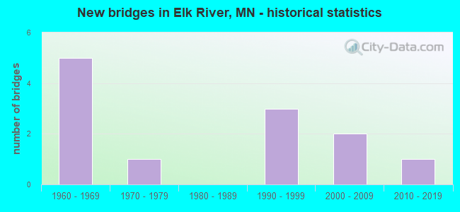
- New bridges - historical statistics
- 51960-1969
- 11970-1979
- 31990-1999
- 22000-2009
- 12010-2019


- Bridge Condition - Deck
- 14.3%Excellent
- 14.3%Very good
- 42.9%Good
- 28.6%Satisfactory

- Bridge Condition - Superstructure
- 14.3%Excellent
- 14.3%Very good
- 42.9%Good
- 28.6%Satisfactory

- Bridge Condition - Substructure
- 14.3%Excellent
- 14.3%Very good
- 42.9%Good
- 28.6%Satisfactory

- Bridge Condition - Channel
- 66.7%Excellent
- 33.3%Satisfactory
Find on map >> Show street view
Structure Number: 71001, Location: AT JCT TH 10 (Lat: 45.291519, Lng: -93.555344), Route carried "on" structure: US 169, Year Built: 1967, Status: Open, Structure Length: 5.28m (17.32ft), Average Daily Traffic: 23,750 (year 2016), Truck Traffic: 7%, Average Future Daily Traffic: 23,750 (year 2039), Design Load: HS 20, Features Intersected: US 10
Minimum Vertical Clearance: 30+ m (98+ ft), Kilometerpoint: 0.000, Lanes on structure: 3, Lanes under structure: 4, Base Highway Network: Yes, Owner: State Highway Agency, Approaching Roadway Width: 11.3m (37.1ft), Skew: 1 degrees, Material/Design: Prestressed concrete, Design/Construction: Stringer/Multi-beam, Number Of Spans In Main Unit: 4, Length of Maximum Span: 15.3m (50.2ft), Curb-To-Curb Width: 11.9m (39.0ft), Out-to-Out Width: 13.6m (44.6ft)
Condition: Deck: Good, Superstructure: Satisfactory, Substructure: Satisfactory, Operating Rating: 60.0 metric tons, Method Used To Determine Operating Rating: Load Factor (LF), Inventory Rating: 36.1 metric tons, Method Used To Determine Inventory Rating: Load Factor (LF), Structural Evaluation: Equal to present minimum criteria, Deck Geometry: High priority of corrective action, Underclear: Somewhat better than minimum adequacy, Approach Roadway Alignment: Equal to present desirable criteria, Length Of Structure Improvement: 1.77m (5.81ft), Designated Inspection Frequency: Every 24 months, Inspection Date: September 2021, Bridge Improvement Cost: $999,999,000, Deck Structure Type: Concrete Cast-file-Place, Wearing Surface/Protective System: Wearing Surface: Low Slump Concrete
Find on map >> Show street view
Structure Number: 71002, Location: AT JCT TH 10 (Lat: 45.291336, Lng: -93.555092), Route carried "on" structure: US 169, Year Built: 1961, Status: Open, Structure Length: 5.41m (17.75ft), Average Daily Traffic: 24,329 (year 2019), Truck Traffic: 6%, Average Future Daily Traffic: 23,750 (year 2039), Design Load: HS 20, Features Intersected: US 10
Minimum Vertical Clearance: 30+ m (98+ ft), Kilometerpoint: 0.000, Lanes on structure: 3, Lanes under structure: 4, Base Highway Network: Yes, Owner: State Highway Agency, Approaching Roadway Width: 14.0m (45.9ft), Skew: 1 degrees, Material/Design: Prestressed concrete, Design/Construction: Stringer/Multi-beam, Number Of Spans In Main Unit: 4, Length of Maximum Span: 15.0m (49.2ft), Curb-To-Curb Width: 15.0m (49.2ft), Out-to-Out Width: 16.0m (52.5ft)
Condition: Deck: Satisfactory, Superstructure: Satisfactory, Substructure: Satisfactory, Operating Rating: 55.1 metric tons, Method Used To Determine Operating Rating: Load Factor (LF), Inventory Rating: 43.1 metric tons, Method Used To Determine Inventory Rating: Load Factor (LF), Structural Evaluation: Equal to present minimum criteria, Deck Geometry: Equal to present minimum criteria, Underclear: Somewhat better than minimum adequacy, Approach Roadway Alignment: Equal to present desirable criteria, Designated Inspection Frequency: Every 24 months, Inspection Date: September 2021, Deck Structure Type: Concrete Cast-file-Place, Wearing Surface/Protective System: Wearing Surface: Low Slump Concrete
Find on map >> Show street view
Structure Number: 71005, Location: 2.7 MI W OF JCT TH 169 (Lat: 45.310078, Lng: -93.597047), Route carried "on" structure: US 10, Year Built: 2017, Status: Open, Structure Length: 5.72m (18.77ft), Average Daily Traffic: 27,658 (year 2019), Truck Traffic: 4%, Average Future Daily Traffic: 27,000 (year 2039), Design Load: HL 93, Features Intersected: ELK RIVER
Minimum Vertical Clearance: 30+ m (98+ ft), Kilometerpoint: 0.000, Lanes on structure: 4, Base Highway Network: Yes, Owner: State Highway Agency, Approaching Roadway Width: 28.6m (93.8ft), Material/Design: Prestressed concrete, Design/Construction: Stringer/Multi-beam, Number Of Spans In Main Unit: 2, Length of Maximum Span: 28.3m (92.8ft), Curb or Sidewalk Widths: Left: 0.0m, Right: 3.0m (9.8ft), Curb-To-Curb Width: 22.8m (74.8ft), Out-to-Out Width: 28.6m (93.8ft)
Condition: Deck: Excellent, Superstructure: Excellent, Substructure: Excellent, Channel: Excellent, Operating Rating: 43.4 metric tons, Method Used To Determine Operating Rating: Load and Resistance Factor Rating (LRFR) rating reported by rating factor(RF) method using HL-93 loadings, Inventory Rating: 33.4 metric tons, Method Used To Determine Inventory Rating: Load and Resistance Factor Rating (LRFR) rating reported by rating factor(RF) method using HL-93 loadings, Structural Evaluation: Superior to present desirable criteria, Deck Geometry: Superior to present desirable criteria, Waterway Adequacy: Superior to present desirable criteria, Approach Roadway Alignment: Equal to present desirable criteria, Designated Inspection Frequency: Every 24 months, Inspection Date: August 2020, Deck Structure Type: Concrete Cast-file-Place, Wearing Surface/Protective System: Wearing Surface: Low Slump Concrete, Deck Protection: Epoxy Coated Reinforcing
Find on map >> Show street view
Structure Number: 71013, Location: 3.6 MI N OF E JCT TH 10 (Lat: 45.342708, Lng: -93.559564), Route carried "on" structure: County highway 33, Year Built: 2003, Status: Open, Structure Length: 7.11m (23.33ft), Average Daily Traffic: 4,100 (year 2018), Average Future Daily Traffic: 3,400 (year 2039), Design Load: HS 25 or greater, Features Intersected: TH 169
Minimum Vertical Clearance: 30+ m (98+ ft), Kilometerpoint: 0.000, Lanes on structure: 2, Lanes under structure: 6, Owner: State Highway Agency, Approaching Roadway Width: 20.7m (67.9ft), Skew: 21 degrees, Material/Design: Prestressed concrete, Design/Construction: Stringer/Multi-beam, Number Of Spans In Main Unit: 2, Length of Maximum Span: 34.7m (113.8ft), Curb or Sidewalk Widths: Left: 0.0m, Right: 3.0m (9.8ft), Curb-To-Curb Width: 20.7m (67.9ft), Out-to-Out Width: 26.9m (88.3ft)
Condition: Deck: Good, Superstructure: Good, Substructure: Good, Operating Rating: 80.4 metric tons, Method Used To Determine Operating Rating: Load Factor (LF), Inventory Rating: 44.5 metric tons, Method Used To Determine Inventory Rating: Load Factor (LF), Structural Evaluation: Better than present minimum criteria, Deck Geometry: Superior to present desirable criteria, Underclear: Better than present minimum criteria, Approach Roadway Alignment: Equal to present desirable criteria, Designated Inspection Frequency: Every 24 months, Inspection Date: August 2021, Deck Structure Type: Concrete Cast-file-Place, Wearing Surface/Protective System: Wearing Surface: Low Slump Concrete, Deck Protection: Epoxy Coated Reinforcing
Find on map >> Show street view
Structure Number: 71509, Location: 3.1 MI S OF JCT CSAH 4 (Lat: 45.399392, Lng: -93.685211), Route carried "on" structure: County highway 15, Year Built: 1972, Status: Posted for load, Structure Length: 4.21m (13.81ft), Average Daily Traffic: 3,400 (year 2014), Average Future Daily Traffic: 3,400 (year 2034), Design Load: HS 20, Features Intersected: ST FRANCIS RIVER
Minimum Vertical Clearance: 30+ m (98+ ft), Kilometerpoint: 0.000, Lanes on structure: 2, Base Highway Network: Yes, Owner: County Highway Agency, Approaching Roadway Width: 11.0m (36.1ft), Material/Design: Wood or Timber, Design/Construction: Stringer/Multi-beam, Number Of Spans In Main Unit: 3, Length of Maximum Span: 14.0m (45.9ft), Curb-To-Curb Width: 11.0m (36.1ft), Out-to-Out Width: 11.6m (38.1ft)
Condition: Deck: Satisfactory, Superstructure: Good, Substructure: Good, Channel: Excellent, Operating Rating: 42.3 metric tons, Method Used To Determine Operating Rating: Allowable Stress (AS), Inventory Rating: 27.3 metric tons, Method Used To Determine Inventory Rating: Allowable Stress (AS), Structural Evaluation: Equal to present minimum criteria, Deck Geometry: Somewhat better than minimum adequacy, Waterway Adequacy: Equal to present desirable criteria, Approach Roadway Alignment: Better than present minimum criteria, Designated Inspection Frequency: Every 24 months, Inspection Date: October 2020, Deck Structure Type: Wood or Timber, Wearing Surface/Protective System: Wearing Surface: Bituminous
Find on map >> Show street view
Structure Number: 71517, Location: 0.4 MI E OF JCT MISS RD (Lat: 45.303936, Lng: -93.585853), Route carried "on" structure: City street 113, Year Built: 1992, Status: Open, Structure Length: 7.33m (24.05ft), Average Daily Traffic: 5,200 (year 2014), Average Future Daily Traffic: 5,200 (year 2039), Design Load: HS 25 or greater, Features Intersected: ELK RIVER
Minimum Vertical Clearance: 30+ m (98+ ft), Kilometerpoint: 0.000, Lanes on structure: 2, Owner: City or Municipal Highway Agency, Approaching Roadway Width: 13.4m (44.0ft), Material/Design: Prestressed concrete, Design/Construction: Stringer/Multi-beam, Number Of Spans In Main Unit: 2, Length of Maximum Span: 36.0m (118.1ft), Curb or Sidewalk Widths: Left: 1.5m (4.9ft), Right: 0.0m, Curb-To-Curb Width: 13.4m (44.0ft), Out-to-Out Width: 15.8m (51.8ft)
Condition: Deck: Good, Superstructure: Good, Substructure: Good, Channel: Satisfactory, Operating Rating: 56.1 metric tons, Method Used To Determine Operating Rating: Load Factor (LF), Inventory Rating: 43.4 metric tons, Method Used To Determine Inventory Rating: Load Factor (LF), Structural Evaluation: Better than present minimum criteria, Deck Geometry: Equal to present minimum criteria, Waterway Adequacy: Superior to present desirable criteria, Approach Roadway Alignment: Equal to present desirable criteria, Designated Inspection Frequency: Every 24 months, Inspection Date: September 2020, Deck Structure Type: Concrete Cast-file-Place, Wearing Surface/Protective System: Wearing Surface: Low Slump Concrete, Deck Protection: Epoxy Coated Reinforcing
Find on map >> Show street view
Structure Number: 71522, Location: 0.6 MI N OF W JCT TH 10 (Lat: 45.314194, Lng: -93.559472), Route carried "on" structure: , Year Built: 1999, Status: Open, Structure Length: 8.20m (26.90ft), Features Intersected: US 169, Facility Carried by Structure: PEDESTRIAN
Lanes under structure: 4, Owner: City or Municipal Highway Agency, Skew: 1 degrees, Material/Design: Prestressed concrete, Design/Construction: Stringer/Multi-beam, Number Of Spans In Main Unit: 2, Length of Maximum Span: 40.0m (131.2ft), Out-to-Out Width: 4.1m (13.5ft)
Condition: Deck: Very good, Superstructure: Very good, Substructure: Very good, Bridge Posting: Required (Relationship of Operating Rating to Maximum Legal Load: > 39.9% below), Designated Inspection Frequency: Every 24 months, Inspection Date: October 2021, Deck Structure Type: Concrete Cast-file-Place, Wearing Surface/Protective System: Deck Protection: Epoxy Coated Reinforcing
Find on map >> Show street view
Structure Number: 71001, Location: AT JCT TH 10 (Lat: 45.291519, Lng: -93.555344), Route carried "under" structure: US 10, Year Built: 1967, Structure Length: 0. m, Average Daily Traffic: 33,608 (year 2019), Truck Traffic: 4%, Features Intersected: US 10, Facility Carried by Structure: US 169
Minimum Vertical Clearance: 5.03m (16.50ft), Kilometerpoint: 0.000, Lanes on structure: 3, Lanes under structure: 4, Material/Design: Prestressed concrete, Design/Construction: Stringer/Multi-beam, Length of Maximum Span: 15.3m (50.2ft)
Find on map >> Show street view
Structure Number: 71002, Location: AT JCT TH 10 (Lat: 45.291336, Lng: -93.555092), Route carried "under" structure: US 10, Year Built: 1961, Structure Length: 0. m, Average Daily Traffic: 33,608 (year 2019), Truck Traffic: 4%, Features Intersected: US 10, Facility Carried by Structure: US 169
Minimum Vertical Clearance: 5.03m (16.50ft), Kilometerpoint: 0.000, Lanes on structure: 3, Lanes under structure: 4, Material/Design: Prestressed concrete, Design/Construction: Stringer/Multi-beam, Length of Maximum Span: 15.0m (49.2ft)
Find on map >> Show street view
Structure Number: 71013, Location: 3.6 MI N OF E JCT TH 10 (Lat: 45.342708, Lng: -93.559564), Route carried "under" structure: US 169, Year Built: 2003, Structure Length: 0. m, Average Daily Traffic: 27,213 (year 2019), Truck Traffic: 8%, Features Intersected: TH 169, Facility Carried by Structure: CSAH 33
Minimum Vertical Clearance: 5.09m (16.70ft), Kilometerpoint: 0.000, Lanes on structure: 2, Lanes under structure: 6, Material/Design: Prestressed concrete, Design/Construction: Stringer/Multi-beam, Length of Maximum Span: 34.7m (113.8ft)
Find on map >> Show street view
Structure Number: 71522, Location: 0.6 MI N OF W JCT TH 10 (Lat: 45.314194, Lng: -93.559472), Route carried "under" structure: US 169, Year Built: 1999, Structure Length: 0. m, Average Daily Traffic: 38,413 (year 2019), Truck Traffic: 7%, Features Intersected: US 169, Facility Carried by Structure: PEDESTRIAN
Minimum Vertical Clearance: 5.24m (17.19ft), Kilometerpoint: 0.000, Lanes on structure: 4, Lanes under structure: 4, Material/Design: Prestressed concrete, Design/Construction: Stringer/Multi-beam, Length of Maximum Span: 40.0m (131.2ft)
Find on map >> Show street view
Structure Number: 948, Location: 0.1 MI N OF N JCT TH 10 (Lat: 45.293861, Lng: -93.553803), Route carried "under" structure: US 169, Year Built: 1961, Structure Length: 0. m, Average Daily Traffic: 48,657 (year 2019), Truck Traffic: 6%, Features Intersected: US 169, Facility Carried by Structure: RAILROAD
Minimum Vertical Clearance: 4.85m (15.91ft), Kilometerpoint: 0.000, Lanes on structure: 4, Lanes under structure: 4, Material/Design: Steel, Design/Construction: Girder and Floorbeam System, Length of Maximum Span: 18.8m (61.7ft)